EP0935227A2 - Map information providing method and terminal device used therein - Google Patents
Map information providing method and terminal device used therein Download PDFInfo
- Publication number
- EP0935227A2 EP0935227A2 EP99101652A EP99101652A EP0935227A2 EP 0935227 A2 EP0935227 A2 EP 0935227A2 EP 99101652 A EP99101652 A EP 99101652A EP 99101652 A EP99101652 A EP 99101652A EP 0935227 A2 EP0935227 A2 EP 0935227A2
- Authority
- EP
- European Patent Office
- Prior art keywords
- information
- map information
- terminal device
- map
- area
- Prior art date
- Legal status (The legal status is an assumption and is not a legal conclusion. Google has not performed a legal analysis and makes no representation as to the accuracy of the status listed.)
- Granted
Links
Images

Classifications
-
- G—PHYSICS
- G01—MEASURING; TESTING
- G01C—MEASURING DISTANCES, LEVELS OR BEARINGS; SURVEYING; NAVIGATION; GYROSCOPIC INSTRUMENTS; PHOTOGRAMMETRY OR VIDEOGRAMMETRY
- G01C21/00—Navigation; Navigational instruments not provided for in groups G01C1/00 - G01C19/00
- G01C21/38—Electronic maps specially adapted for navigation; Updating thereof
- G01C21/3885—Transmission of map data to client devices; Reception of map data by client devices
- G01C21/3896—Transmission of map data from central databases
-
- G—PHYSICS
- G01—MEASURING; TESTING
- G01C—MEASURING DISTANCES, LEVELS OR BEARINGS; SURVEYING; NAVIGATION; GYROSCOPIC INSTRUMENTS; PHOTOGRAMMETRY OR VIDEOGRAMMETRY
- G01C21/00—Navigation; Navigational instruments not provided for in groups G01C1/00 - G01C19/00
- G01C21/38—Electronic maps specially adapted for navigation; Updating thereof
- G01C21/3863—Structures of map data
- G01C21/387—Organisation of map data, e.g. version management or database structures
- G01C21/3881—Tile-based structures
-
- G—PHYSICS
- G08—SIGNALLING
- G08G—TRAFFIC CONTROL SYSTEMS
- G08G1/00—Traffic control systems for road vehicles
- G08G1/09—Arrangements for giving variable traffic instructions
- G08G1/0962—Arrangements for giving variable traffic instructions having an indicator mounted inside the vehicle, e.g. giving voice messages
- G08G1/0968—Systems involving transmission of navigation instructions to the vehicle
- G08G1/0969—Systems involving transmission of navigation instructions to the vehicle having a display in the form of a map
Definitions
- the present invention relates to map information providing methods and a terminal device used in the methods, and more particularly to a map information providing method in which a base station provides a plurality of kinds of map information through a broadcast channel to a terminal device which can move freely in the service area and to the terminal device used in the method.
- Japanese Patent Laying-Open No. 8-22246 discloses a map information providing system in which a base station and terminal devices are communicably connected so that the terminal devices can receive and display map information transmitted from the base station. More specifically, the base station transmits predetermined map information to terminal devices. The terminal devices receive and display the map information so that the users can utilize the map information.
- the users do not always utilize all map information transmitted from the base station, so they will want to store only necessary map information in storage devices.
- conventional map information providing systems do not allow the terminal devices to select required information out of the map. information transmitted. Therefore they must store the map information including unnecessary information in the storage devices. This requires that the terminal devices be equipped with storage devices having larger capacity than required.
- map information is frequently updated because of constructions of new roads and buildings, for example.
- the conventional terminal devices are incapable of managing versions of the map information, and they repeatedly receive map information of the same version and store the information in storage devices, which also leads to an increase in capacity of the storage devices.
- an object of the present invention is to provide a map information providing method in which a terminal device can select required information from among map information transmitted from a base station and the terminal device used in this method.
- the object of the present invention is achieved by the following characteristic aspects having the peculiar effects below.
- a first aspect of the present invention is directed to a method in which a base station provides a plurality of kinds of map information through a broadcast channel to a terminal device mobile in a service area.
- the base station comprises an adding step of adding index information about areas and scales of individual pieces of map information respectively to the individual pieces of map information, and a transmitting step of transmitting the map information accompanied by the index information by using the channel
- the terminal device comprises a receiving step of receiving the map information transmitted on the channel, a map specifying step of specifying an area and a scale of a required piece of map information on the basis of an external input, and a first storage step of storing the map information corresponding to the specified area and scale among the map information received.
- the base station transmits a plurality of kinds of map information together with the index information.
- the terminal device selects required information out of the map information received by utilizing the index information. Accordingly the terminal device does not store unnecessary map information. This allows the terminal device to use a storage device with smaller capacity than conventional ones.
- the base station further adds version information of the map information as the index information in the adding step
- the terminal device further comprises a second storage step of storing the newest map information among the received map information on the basis of the version information.
- the terminal device can store only the newest map information transmitted from the base station. This allows the terminal device,to use a storage device with smaller capacity than conventional ones.
- the base station further transmits traffic information and/or area information about the service area in the transmitting step
- the terminal device further comprises an information specifying step of specifying required traffic information and/or area information on the basis of an external input.
- the terminal device further receives the traffic information and/or the area information transmitted on the channel in the receiving step, and stores the specified traffic information and/or area information among the received traffic information and/or area information in the first storage step.
- the terminal device can be used more conveniently because it can utilize traffic information and area information, too.
- a plurality of base stations are provided in the service area, and the service area is covered by cells respectively defining areas in which the base stations can transmit the map information, and the map information in the vicinity of a boundary between adjacent cells is transmitted from the individual base stations forming the cells.
- the terminal device can smoothly acquire the map information even when moving over a plurality of cells, since the map information in the vicinity of boundaries between cells is transmitted from a plurality of base stations.
- the plurality of base stations periodically transmit the map information accompanied by the index information by using the different channels and also transmit identification signals so that the terminal device can identify the channels respectively assigned to the base stations, and the terminal device further comprises a search/identify step of automatically searching and identifying the channels respectively assigned to the base stations on the basis of the identification signals transmitted from the individual base stations.
- the terminal device can search and identify channels of the base stations respectively on the basis of the identification signals, so that it can smoothly acquire the map information even when moving beyond a plurality of cells.
- the base station transmits newest road network data corresponding to the areas and scales of the map information in the transmitting step, thereby allowing the terminal device to execute a route search in accordance with an arbitrary distance.
- the terminal device when it has a route search function, it can perform the route search by using the newest road network data for each area and scale specified by the map specifying portion, and it can thus appropriately perform the route search in accordance with an arbitrary distance.
- a seventh aspect of the present invention is directed to a terminal device constructed to be mobile in a service area and utilizing predetermined map information among a plurality of kinds of map information transmitted on a broadcast channel from a base station.
- the base station transmits the plurality of kinds of map information and index information about areas and scales of individual pieces of the map information by using the channel
- the terminal device comprises a map specifying portion for specifying an area and a scale of required map information on the basis of an external input, a receiving portion for receiving the map information transmitted on the channel, a discriminating portion for discriminating (to discriminate means to pick out the information a user specified from among pieces of transmitted information) the map information corresponding to the area and scale specified by the map specifying portion among the map information received at the receiving portion, and a storage portion for storing the map information discriminated by the discriminating portion.
- the terminal device receives a plurality of kinds of map information provided with index information and selects/rejects the received map information on the basis of the index information. Accordingly the terminal device does not store unwanted map information. Then the terminal device can use a storage device with smaller capacity than conventional ones.
- the terminal device further comprises a display portion for displaying the map information discriminated by the discriminating portion or the map information stored in the storage portion.
- the display portion displays the map information and the terminal device can therefore be used more conveniently.
- the terminal device further comprises a current position obtaining portion for obtaining its own current position, and the discriminating portion discriminates map information including the current position obtained by the current position obtaining portion among the map information received at the receiving portion.
- the terminal device stores map information including the current position that the current position obtaining portion obtained. That is to say, the terminal device selects/rejects received map information on the basis of the current position obtained by the current position obtaining portion. This allows the terminal device to use a storage device with smaller capacity than conventional ones.
- the terminal device further comprises a display portion for displaying the map information discriminated by the discriminating portion or the map information stored in the storage portion and the current position obtained by the current position obtaining portion.
- the terminal device can be conveniently used since the display portion displays the current position.
- the terminal device further comprises a destination specifying portion for specifying a destination on the basis of an external input, and a route searching portion for searching for a route to the destination specified by the destination specifying portion by referring to the map information previously stored in the storage portion, and the discriminating portion further discriminates the map information including the route found by the route searching portion.
- the terminal device stores only the map information including the route found by the route searching portion and represented on the currently required scale among the plurality of kinds of map information transmitted from the base station. Accordingly the terminal device can use a storage device with smaller capacity than conventional ones.
- the terminal device further comprises a display portion for displaying the map information discriminated by the discriminating portion and including the route found by the route searching portion.
- the display portion displays map information including the route found by the route searching portion and therefor the terminal device can be used more conveniently.
- the terminal device further comprises a current position obtaining portion for obtaining its own current position, and the route searching portion searches for a route to the destination from the current position obtained by the current position obtaining portion and the discriminating portion discriminates the map information including the route from the current position to the destination found by the route searching portion.
- the terminal device stores map information including the route from the current position to a destination among a plurality of kinds of map information transmitted from the base station. Accordingly the terminal device can use a storage device with smaller capacity than conventional ones.
- the terminal device further comprises a display portion for displaying the map information discriminated by the discriminating portion and including the route found by the route searching portion.
- the display portion displays map information including the route found by the route searching portion, and the terminal device can therefore be used more conveniently.
- the base station transmits traffic information and/or area information about the service area and the terminal device further comprises an information specifying portion for specifying required traffic information and/or area information on the basis of an external input.
- the receiving portion receives the traffic information and/or area information transmitted on the channel and the discriminating portion discriminates the traffic information and/or area information specified by the information specifying portion among the traffic information and/or area information received at the receiving portion.
- the terminal device can be used more conveniently since it can utilize the traffic information and area information.
- the terminal device further comprises a display portion for displaying the traffic information and/or area information discriminated by the discriminating portion alone or together with the map information discriminated by the discriminating portion.
- the display portion at least displays the traffic information and/or area information, and therefore the user can easily utilize the traffic information and/or area information and the terminal device can thus be used more conveniently.
- the traffic information and/or area information includes a telephone number
- the terminal device further comprises a telephone line connecting portion for making a call to the telephone number included in the traffic information and/or area information displayed on the display portion.
- the telephone line connecting portion gives a call to the telephone number included in the traffic information and/or area information. Then the user can easily utilize the traffic information and/or area information and the terminal device can thus be used more conveniently.
- an information storage portion containing detailed information related to the traffic information and/or area information is connected to the telephone line, and the telephone line connecting portion obtains the detailed information related to the traffic information and/or area information stored in the information storage portion through the telephone line.
- the telephone line connecting portion obtains detailed information related to the traffic information and/or area information stored in the information storage portion through the telephone line.
- the user can easily utilize the traffic information and/or area information and the terminal device can be used more conveniently.
- the traffic information and/or area information includes URL (Uniform Resource Locator), and a WWW (World Wide Web) server containing detailed information related to the traffic information and/or area information is connected to the telephone line through Internet.
- the telephone line connecting portion connects to the WWW server through the telephone line and the Internet to obtain the detailed information related to the traffic information and/or area information specified by the URL.
- the telephone line connecting portion can obtain the detailed information related to the traffic information and/or area information stored in the WWW server through the telephone line and Internet. Then the user can use the terminal device more conveniently by easily utilizing the traffic information and/or area information.
- the base station also periodically transmits, by using the channel, version information about the map information to be transmitted and the discriminating portion discriminates the newest map information among the map information received at the receiving portion on the basis of the version information.
- the terminal device stores only the newest map information transmitted from the base station. Then the terminal device can use a storage device with smaller capacity than conventional ones.
- the map information includes road network data
- the discriminating portion discriminates the newest road network data on the basis of the version information.
- the terminal device can utilize the newest road network data and it can thus be used further conveniently.
- the terminal device further comprises a destination specifying portion for specifying a destination on the basis of an external input, and a route searching portion for searching for a route to the destination specified by the destination specifying portion by referring to the road network data previously stored in the storage portion.
- the route searching portion searches for the route to the destination on the basis of the newest road network data.
- the route searching portion searches for the route to a destination on the basis of the newest road network data so as to correctly guide the user to the destination, and the terminal device can thus be used further conveniently.
- the map information includes link cost
- the discriminating portion further discriminates the newest link cost on the basis of the version information.
- the terminal device can utilize the newest link cost and it can be used still more conveniently.
- the terminal device further comprises a destination specifying portion for specifying a destination on the basis of an external input, and a route searching portion for searching for a route to the destination specified by the destination specifying portion by referring to the link cost previously stored in the storage portion.
- the route searching portion searches for the route to the destination on the basis of the newest link cost.
- the route searching portion searches for the route to a destination on the basis of the newest link cost so that it can correctly guide the user to the destination, and the terminal device can thus be used more conveniently.
- a plurality of base stations are provided and the service area in which the map information can be provided is covered by a plurality of cells respectively defining areas in which the base stations can transmit the map information.
- the base stations transmit the map information and the index information by using different channels and also transmit identification signals for identification of the channels, and the terminal device further comprises a channel identifying portion for automatically searching and identifying the channels used by the base stations on the basis of the identification signals received.
- the terminal device can obtain the map information by using channels automatically searched and identified by the channel identifying portion, and it can thus smoothly receive the map information even while moving over a plurality of cells.
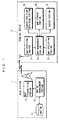
- Fig.1 is a diagram showing the structure of a system to which a map information providing method of an embodiment of the present invention is applied.
- this system includes a base station 1 and a terminal device 2.
- the base station 1 provides map information in broadcast form to the terminal device 2 which is mobile in the service area.
- the base station 1 has a map database (hereinafter referred to as a map DB) 11, a map DB management portion 12, and a map transmitting portion 13.
- the map DB11 is a database for map information, which is managed by the map DB management portion 12 .
- the map information is composed of part of or a combination of map data, road network data, additional information, etc.
- the map data are used for display in the terminal device 2.
- the road network data are used to detect the current position of the terminal device 2 (typically, a vehicle) or used for route search in the route searching portion 72 described later. Since these data are used in conventional car navigation systems, they are not specifically described herein.
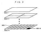
- Fig.2 is a diagram showing an example of structure of the map information stored in the map DB 11.
- Stored in the map DB 11 are multiple pieces of map information which represent a predetermined area on N levels of scales 1 to N. Specifically, a predetermined area is divided into four rectangular areas on the scale 2, and is divided into M rectangular areas 1 to M on the scale N, and then the divided areas are stored. The individual rectangular areas are provided with area numbers, which allow the terminal device 2 to identify the areas shown by the map information. In this embodiment, one rectangular area represents the smallest area at the scale N, which shows the corresponding area in greater detail than those at other scales. In this embodiment, a predetermined area is divided into rectangular areas merely by way of example, and a predetermined area can be divided into arbitrary shape.
- the map DB 11 thus contains multiple kinds of map information.
- the map DB management portion 12 manages the storage locations of individual pieces of map information in the map DB 11.
- the map DB management portion 12 reads and outputs the map information to the map transmitting portion 13 according to a program previously stored therein (not shown).
- the map transmitting portion 13 transmits the map information provided from the map DB management portion 12 through an antenna. The map information is thus provided in broadcast form to the individual terminal devices 2 moving freely in the service area.
- This embodiment uses frequency division multiplex technique or time division multiplex technique to transmit the plurality of kinds of map information.
- the map transmitting portion 13 uses carriers having different frequencies as a plurality of broadcast channels. Different reduction scales and areas are previously assigned to the individual channels.
- the map transmitting portion 13 periodically transmits the map information by using the plurality of broadcast channels.
- the terminal device 2 can thus obtain map information, which is required by its user, through a particular broadcast channel.
- the frequency division multiplex technique cannot be applied to the map transmitting portion 13, the time division multiplex technique is applied to it.
- a plurality of time slots is used as the plurality of broadcast channels. The time slots are those obtained by dividing a carrier having a predetermined frequency in predetermined time intervals.
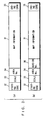
- a plurality of kinds of map information is transmitted in this embodiment. Therefore, index information composed of a starting code 32, a scale 33, an area number 34, and an ending code 35, is added to the each map information 31, as shown in Fig. 3(a), so that the terminal device 2 can discriminate required map information.
- the starting code 32 and the ending code 35 allow correct separation of the scale 33, area number 34, and map information 31.
- the terminal device 2 analyzes the scale 33 and the area number 34 to determine whether the map information 31 having them is the information of scale and area specified by the user.
- a version number 36 may be added to the map information 31.
- the version number 36 is typically based on the time when the map information 31 was created.
- the terminal device 2 executes version management as described later on the basis of the version numbers 36.
- the terminal device 2 has a map receiving portion 21, a map specifying portion 22, a map management portion (which corresponds to the discriminating portion in claims) 23, a current position obtaining portion 24, an output portion (which corresponds to the display portion in claims) 25, and a map storage portion 26.
- the map receiving portion 21 receives the map information 31 and its index information transmitted from the base station 1 through an antenna.
- the map specifying portion 22 includes input equipment such as a remote controller, keyboard, etc. The user of this terminal device 2 operates the input equipment to enter scale and area of the currently required map information 31.
- the map specifying portion 22 specifies the scale and area of the currently required map information 31 according to the input by the user.
- the map management portion 23 discriminates the map information 31 of the scale and area specified by the map specifying portion 22 and its index information from among the pieces of map information 31 and their index information received at the map receiving portion 21. Then the map management portion 23 stores the discriminated information in the map storage portion 26.
- the current position obtaining portion 24 obtains the current position of the terminal device 2.
- the output portion 25 includes a display, a speaker, etc. for displaying the map information 31 required by the user, or for providing the information by speech guide.
- the map information 31 which was demanded by the user in the past and the corresponding index information are stored in the map storage portion 26.
- the base station 1 adds necessary index information (the starting code 32, scale 33, area number 34, and ending code 35 (see Fig.3(a)) to the individual pieces of map information 31 (step S41 in Fig.4).
- the base station 1 transmits the map information 31 and index information by using the above-described channels (step S42)
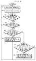
- the map receiving portion 21 of the terminal device 2 receives the map information 31 and the index information transmitted from the broadcast channels at the antenna (step S51 in Fig.5) and temporarily holds the information.
- the current position obtaining portion 24 obtains the current position of the mobile terminal device 2.
- the map management portion 23 receives the current position of the terminal device 2 from the current position obtaining portion 24 (step S52).
- the map management portion 23 checks whether the map information 31 temporarily held in the map receiving portion 21 includes map information 31 containing the current position of the terminal device 2 (step S53).
- the step S53 is now described more specifically.
- the current position obtaining portion 24 is typically composed of a GPS (Global Positioning System) receiver.
- the current position of the terminal device 2 obtained by the GPS receiver is typically represented in latitude and longitude.
- the map management portion 23 previously contains a table describing the correspondence between the area numbers and the latitudes and longitudes of the areas represented by the area numbers.
- the map management portion 23 refers to this table to find the area number corresponding to the current position of the terminal device 2.
- the map management portion 23 then compares the area number found and the area number 34 added to the map information 31 temporarily held in the map receiving portion 21 to discriminate the map information 31 containing the current position of the terminal device 2.
- the base station 1 may allow information about latitudes and longitudes of the areas to be included in the corresponding area numbers 34 added to the map information 31.
- step S51 When the map receiving portion 21 does not hold the map information 31 containing the current position of the terminal device 2, the map management portion 23 returns to step S51 to execute the process of receiving the periodically transmitted map information again.
- the map receiving portion 21 holds the map information 31 containing the current position of the terminal device 2, the map management portion 23 proceeds to step S54.
- the user of the terminal device 2 has already entered the scale and area of required map information by using the above-described input equipment, and the map specifying portion 22 has indicated the input scale and area to the map management portion 23.
- the map management portion 23 analyzes the scale 33 and area number 34 of the map information 31 currently held in the map receiving portion 21 to see whether it holds the map information 31 of the scale and area the user requires (step S54).
- the map management portion 23 returns to step S51 to re-execute the process of receiving the periodically transmitted map information.
- the map management portion 23 takes out that map information 31 and its index information.
- the user is not necessarily required to enter the scale and area of the map information 31.
- the scale and area of the map information 31 may be previously set in the terminal device 2 so that the map management portion 23 can take out the map information 31 corresponding to the previously set scale and area.
- the map storage portion 26 contains map information 31 that the terminal device 2 obtained in the past from the base station 1 and the index information thereof.
- the map management portion 23 analyzes the scales 33 and the area numbers 34 of the map information 31 already stored in the map storage portion 26 to see whether it contains the map information 31 of the scale and area the user wants (step S55).
- the map management portion 23 takes out the corresponding map information 31 and outputs it from the output portion 25 by displaying it on the monitor, for example. Then the user can utilize the required map information 31.
- the terminal device 2 returns to step S51 to re-execute the process of receiving the map information 31.
- the map management portion 23 stores the map information 31 and its index information taken out from the map receiving portion 21 immediately after step S52 (step S56) and outputs it from the output portion 25.
- the map storage portion 26 selects and stores map information 31 that the user requires from among a plurality of kinds of map information received. Then a storage device having smaller capacity than conventional ones can be used in the map storage portion 26.
- the terminal device 2 executes the operation as shown in the flowchart in Fig.6.
- Fig.6 the steps corresponding to those already described referring to Fig.5 are shown by the same step numbers and not described again.
- step S61 the map management portion 23 compares the version numbers 36 added to the information held in the map receiving portion 21 and the information already stored in the map storage portion 26 to see whether the map information 31 in the map receiving portion 21 is of a newer version than the map information 31 in the map storage portion 26 (step S61) -
- step S62 the map management portion 23 takes out the newer version map information 31 and its index information from the map receiving portion 21 and stores them in the map storage portion 26 (step S62).
- the map information 31 of older version and its index information are deleted after this step S62, so as to efficiently utilize the capacity of the map storage portion 26.
- the map storage portion 26 stores map information 31 of newer versions only. Accordingly, a storage device with a smaller storage capacity than conventional ones can be used in the map storage portion 26.
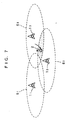
- Fig.7 is a diagram used to explain a system adopting the cell system and containing a plurality of base stations 1.
- the system in Fig.7 includes three base stations 1 1 to 1 3 .
- the base stations 1 1 to 1 3 have their respective cover areas (hereinafter referred to as cells) 6 1 to 6 3 .
- the sizes of the cells 6 1 to 6 3 are defined on the basis of the area in which radio waves (map information) transmitted from the base stations 1 1 to 1 3 can reach.
- the base stations 1 1 to 1 3 transmit the map information 31 in which the areas corresponding to their respective cells 6 1 to 6 3 are divided into predetermined regions on the individual scale steps.
- the terminal device 2 gets map information 31 the user requires while freely moving in the service area composed of the three cells 6 1 to 6 3 .
- map information 31 showing the regions near boundaries between cells 6 are transmitted from a plurality of base stations 1 provided in the corresponding cells 6.
- the map information 31 about the dotted portion is transmitted from the base stations 1 2 and 1 3 .
- the terminal device 2 can smoothly acquire the map information 31 about the parts in the vicinities of the boundaries.
- the base stations 1 also periodically transmit identification signals showing contents of the map information 31 sent in their respective broadcast channels so that the terminal device 2 can identify the respective broadcast channels of the base stations 1.
- the identification signal is transmitted by using free part in the broadcast channel (i.e., the part in which the map information 31 and the index information are not transmitted).
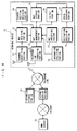
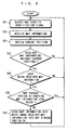
- the terminal device 2 contains a channel identifying portion 71 preceding the map receiving portion 21.
- the channel identifying portion 71 searches the identification signals transmitted in a cell 6 to identify a required broadcast channel (i.e., a channel in which the user-required map information 31 is transmitted) (step S91).
- step S91 the processing in and after step S51 described referring to Fig.5 are executed.
- the map terminal 2 automatically searches the broadcast channels to continuously get the map information 31 without requiring operation by the user, which allows smoother acquisition of the map information 31 near boundaries even when the terminal device 2 is moving over a plurality of cells 6.
- the terminal device 2 may contain a route searching portion 72 for obtaining a rough route to a destination by using rough map information 31 previously stored in the map storage portion 26 and a destination specifying portion 73 having input equipment similar to the map specifying portion 22 and used by the user to set the destination.
- the route searching portion 72 is widely used for the route search function in car navigation systems, which is configured with algorithm based on the Dijkstra method.
- the route searching portion 72 searches for an approximate route from a predetermined position (e.g. the current position obtained by the above-described current position obtaining portion 24) to the destination set by the destination specifying portion 73.
- the map management portion 23 discriminates the map information 31 which is represented on the scale specified by the user and required to display the route found by the route searching portion 72 in the screen of the output portion 25 from among the map information 31 temporarily held in the map receiving portion 21. Then the output portion 25 and the map storage portion 26 display and store the map information 31 discriminated by the map management portion 23.
- the map information 31 may include road network data and/or link cost.
- the road network data is the data representing connections among roads
- the road link cost is data about times or distances for moving between links or nodes (intersections).
- the terminal device 2 can know whether the road network data and/or link cost added to the map information 31 has been updated by referring to the version information 36 (see Fig. 3(b)) included in the index information of the map information 31 required to display the route to the destination, and it can also automatically receive and store the updated map information 31.
- the route searching portion can also automatically re-execute the route search on the basis of updated road network data and/or link cost. In this way, the newest road network data and/or link cost can be used in the route search for each area and scale specified, which allows the terminal device 2 to appropriately perform the route search in accordance with arbitrary distances.
- the base station 1 may add area information typically representing restaurants and sight-seeing spots in the service area and/or traffic information in step S41 of Fig.4 and transmit not only the map information 31 but also the additional area information and/or traffic information through the broadcast channel in step S42.
- the base station 1 similarly to the map information 31, transmits area information and/or traffic information containing information, ID, or keyword showing the contents of the area information and/or traffic information in the index information.
- the terminal device 2 further contains an information specifying portion 74 having input equipment similar to the map specifying portion 22. Then, similarly to the operation with the map information 31, it can selectively receive only area information and/or traffic information that are specified by the information specifying portion 74 on the basis of the information etc.
- the map receiving portion 21 receives the traffic information and/or area information (step S51) and temporarily holds the information.
- the user of the terminal device 2 enters required traffic information and/or area information by using the input equipment of the information specifying portion 74, and the information specifying portion 74 indicates the input information to the map management portion 23.
- the map management portion 23 analyzes the information showing the contents of the area information and/or traffic information received, so as to see whether the map receiving portion 21 holds the specified traffic information and/or area information (step S54).
- the terminal device 2 can display or speech-output the received area information alone from the output portion 25.
- the area information contains positional information about restaurants and sight-seeing spots, it can display the restaurants and sight-seeing spots on the map together with the map information 31.
- the terminal device 2 can display the received traffic information alone in the output portion 25 or speech-output it by itself from the output portion 25, it can also display it in the map information 31 (map data for display) or can include it in the road network data for route search to dynamically perform the route search in accordance with the traffic information.
- the telephone line connecting portion 75 can automatically make a call to the telephone number when the user selects the area information. Further, when an information storage portion 76 containing detailed information related to the area information is connected to the telephone line, the telephone line connecting portion 75 can get the detailed information related to the area information stored in the information storage portion 76 through the telephone line. The same operation can be applied also to the traffic information.
- the telephone line connecting portion 75 can access to the WWW server 78 through the telephone line, internet service provider (SP) 77, and internet as shown in Fig.8 to obtain the detailed information related to the area information specified by URL.
- SP internet service provider
- map specifying portion 22 destination specifying portion 73, and information specifying portion 74 have been explained as different structures for convenience in the embodiment above, these are usually realized with the same input equipment.
Abstract
Description
- The present invention relates to map information providing methods and a terminal device used in the methods, and more particularly to a map information providing method in which a base station provides a plurality of kinds of map information through a broadcast channel to a terminal device which can move freely in the service area and to the terminal device used in the method.
- Conventionally, for example, Japanese Patent Laying-Open No. 8-22246 discloses a map information providing system in which a base station and terminal devices are communicably connected so that the terminal devices can receive and display map information transmitted from the base station. More specifically, the base station transmits predetermined map information to terminal devices. The terminal devices receive and display the map information so that the users can utilize the map information.
- In this case, the users do not always utilize all map information transmitted from the base station, so they will want to store only necessary map information in storage devices. However, conventional map information providing systems do not allow the terminal devices to select required information out of the map. information transmitted. Therefore they must store the map information including unnecessary information in the storage devices. This requires that the terminal devices be equipped with storage devices having larger capacity than required.
- Further, the map information is frequently updated because of constructions of new roads and buildings, for example. However, the conventional terminal devices are incapable of managing versions of the map information, and they repeatedly receive map information of the same version and store the information in storage devices, which also leads to an increase in capacity of the storage devices.
- Accordingly, an object of the present invention is to provide a map information providing method in which a terminal device can select required information from among map information transmitted from a base station and the terminal device used in this method. The object of the present invention is achieved by the following characteristic aspects having the peculiar effects below.
- A first aspect of the present invention is directed to a method in which a base station provides a plurality of kinds of map information through a broadcast channel to a terminal device mobile in a service area. In the map information providing method, the base station comprises an adding step of adding index information about areas and scales of individual pieces of map information respectively to the individual pieces of map information, and a transmitting step of transmitting the map information accompanied by the index information by using the channel, and the terminal device comprises a receiving step of receiving the map information transmitted on the channel, a map specifying step of specifying an area and a scale of a required piece of map information on the basis of an external input, and a first storage step of storing the map information corresponding to the specified area and scale among the map information received.
- According to the first aspect, the base station transmits a plurality of kinds of map information together with the index information. The terminal device selects required information out of the map information received by utilizing the index information. Accordingly the terminal device does not store unnecessary map information. This allows the terminal device to use a storage device with smaller capacity than conventional ones.
- According to a second aspect, in the first aspect, the base station further adds version information of the map information as the index information in the adding step, and the terminal device further comprises a second storage step of storing the newest map information among the received map information on the basis of the version information.
- According to the second aspect, the terminal device can store only the newest map information transmitted from the base station. This allows the terminal device,to use a storage device with smaller capacity than conventional ones.
- According to a third aspect, in the first aspect, the base station further transmits traffic information and/or area information about the service area in the transmitting step, and the terminal device further comprises an information specifying step of specifying required traffic information and/or area information on the basis of an external input. The terminal device further receives the traffic information and/or the area information transmitted on the channel in the receiving step, and stores the specified traffic information and/or area information among the received traffic information and/or area information in the first storage step.
- According to the third aspect, the terminal device can be used more conveniently because it can utilize traffic information and area information, too.
- According to a fourth aspect, in the first aspect, a plurality of base stations are provided in the service area, and the service area is covered by cells respectively defining areas in which the base stations can transmit the map information, and the map information in the vicinity of a boundary between adjacent cells is transmitted from the individual base stations forming the cells.
- According to the fourth aspect, the terminal device can smoothly acquire the map information even when moving over a plurality of cells, since the map information in the vicinity of boundaries between cells is transmitted from a plurality of base stations.
- According to a fifth aspect, in the fourth aspect, in the transmitting step, the plurality of base stations periodically transmit the map information accompanied by the index information by using the different channels and also transmit identification signals so that the terminal device can identify the channels respectively assigned to the base stations, and the terminal device further comprises a search/identify step of automatically searching and identifying the channels respectively assigned to the base stations on the basis of the identification signals transmitted from the individual base stations.
- According to the fifth aspect, the terminal device can search and identify channels of the base stations respectively on the basis of the identification signals, so that it can smoothly acquire the map information even when moving beyond a plurality of cells.
- According to a sixth aspect, in the first aspect, the base station transmits newest road network data corresponding to the areas and scales of the map information in the transmitting step, thereby allowing the terminal device to execute a route search in accordance with an arbitrary distance.
- According to the sixth aspect, when the terminal device has a route search function, it can perform the route search by using the newest road network data for each area and scale specified by the map specifying portion, and it can thus appropriately perform the route search in accordance with an arbitrary distance.
- A seventh aspect of the present invention is directed to a terminal device constructed to be mobile in a service area and utilizing predetermined map information among a plurality of kinds of map information transmitted on a broadcast channel from a base station. The base station transmits the plurality of kinds of map information and index information about areas and scales of individual pieces of the map information by using the channel, and the terminal device comprises a map specifying portion for specifying an area and a scale of required map information on the basis of an external input, a receiving portion for receiving the map information transmitted on the channel, a discriminating portion for discriminating (to discriminate means to pick out the information a user specified from among pieces of transmitted information) the map information corresponding to the area and scale specified by the map specifying portion among the map information received at the receiving portion, and a storage portion for storing the map information discriminated by the discriminating portion.
- According to the seventh aspect, the terminal device receives a plurality of kinds of map information provided with index information and selects/rejects the received map information on the basis of the index information. Accordingly the terminal device does not store unwanted map information. Then the terminal device can use a storage device with smaller capacity than conventional ones.
- According to an eighth aspect, in the seventh aspect, the terminal device further comprises a display portion for displaying the map information discriminated by the discriminating portion or the map information stored in the storage portion.
- According to the eighth aspect, the display portion displays the map information and the terminal device can therefore be used more conveniently.
- According to a ninth aspect, in the seventh aspect, the terminal device further comprises a current position obtaining portion for obtaining its own current position, and the discriminating portion discriminates map information including the current position obtained by the current position obtaining portion among the map information received at the receiving portion.
- According to the ninth aspect, the terminal device stores map information including the current position that the current position obtaining portion obtained. That is to say, the terminal device selects/rejects received map information on the basis of the current position obtained by the current position obtaining portion. This allows the terminal device to use a storage device with smaller capacity than conventional ones.
- According to a tenth aspect, in the ninth aspect, the terminal device further comprises a display portion for displaying the map information discriminated by the discriminating portion or the map information stored in the storage portion and the current position obtained by the current position obtaining portion.
- According to the tenth aspect, the terminal device can be conveniently used since the display portion displays the current position.
- According to an eleventh aspect, in the seventh aspect, the terminal device further comprises a destination specifying portion for specifying a destination on the basis of an external input, and a route searching portion for searching for a route to the destination specified by the destination specifying portion by referring to the map information previously stored in the storage portion, and the discriminating portion further discriminates the map information including the route found by the route searching portion.
- According to the eleventh aspect, the terminal device stores only the map information including the route found by the route searching portion and represented on the currently required scale among the plurality of kinds of map information transmitted from the base station. Accordingly the terminal device can use a storage device with smaller capacity than conventional ones.
- According to a twelfth aspect, in the eleventh aspect, the terminal device further comprises a display portion for displaying the map information discriminated by the discriminating portion and including the route found by the route searching portion.
- According to the twelfth aspect, the display portion displays map information including the route found by the route searching portion and therefor the terminal device can be used more conveniently.
- According to a thirteenth aspect, in the eleventh aspect, the terminal device further comprises a current position obtaining portion for obtaining its own current position, and the route searching portion searches for a route to the destination from the current position obtained by the current position obtaining portion and the discriminating portion discriminates the map information including the route from the current position to the destination found by the route searching portion.
- According to the thirteenth aspect, the terminal device stores map information including the route from the current position to a destination among a plurality of kinds of map information transmitted from the base station. Accordingly the terminal device can use a storage device with smaller capacity than conventional ones.
- According to a fourteenth aspect, in the thirteenth aspect, the terminal device further comprises a display portion for displaying the map information discriminated by the discriminating portion and including the route found by the route searching portion.
- According to the fourteenth aspect, the display portion displays map information including the route found by the route searching portion, and the terminal device can therefore be used more conveniently.
- According to a fifteenth aspect, in the seventh aspect, the base station transmits traffic information and/or area information about the service area and the terminal device further comprises an information specifying portion for specifying required traffic information and/or area information on the basis of an external input. The receiving portion receives the traffic information and/or area information transmitted on the channel and the discriminating portion discriminates the traffic information and/or area information specified by the information specifying portion among the traffic information and/or area information received at the receiving portion.
- According to the fifteenth aspect, the terminal device can be used more conveniently since it can utilize the traffic information and area information.
- According to a sixteenth aspect, in the fifteenth aspect, the terminal device further comprises a display portion for displaying the traffic information and/or area information discriminated by the discriminating portion alone or together with the map information discriminated by the discriminating portion.
- According to the sixteenth aspect, the display portion at least displays the traffic information and/or area information, and therefore the user can easily utilize the traffic information and/or area information and the terminal device can thus be used more conveniently.
- According to a seventeenth aspect, in the sixteenth aspect, the traffic information and/or area information includes a telephone number, and the terminal device further comprises a telephone line connecting portion for making a call to the telephone number included in the traffic information and/or area information displayed on the display portion.
- According to the seventeenth aspect, the telephone line connecting portion gives a call to the telephone number included in the traffic information and/or area information. Then the user can easily utilize the traffic information and/or area information and the terminal device can thus be used more conveniently.
- According to an eighteenth aspect, in the seventeenth aspect, an information storage portion containing detailed information related to the traffic information and/or area information is connected to the telephone line, and the telephone line connecting portion obtains the detailed information related to the traffic information and/or area information stored in the information storage portion through the telephone line.
- According to the eighteenth aspect, the telephone line connecting portion obtains detailed information related to the traffic information and/or area information stored in the information storage portion through the telephone line. Thus the user can easily utilize the traffic information and/or area information and the terminal device can be used more conveniently.
- According to a nineteenth aspect, in the seventeenth aspect, the traffic information and/or area information includes URL (Uniform Resource Locator), and a WWW (World Wide Web) server containing detailed information related to the traffic information and/or area information is connected to the telephone line through Internet. The telephone line connecting portion connects to the WWW server through the telephone line and the Internet to obtain the detailed information related to the traffic information and/or area information specified by the URL.
- According to the nineteenth aspect, the telephone line connecting portion can obtain the detailed information related to the traffic information and/or area information stored in the WWW server through the telephone line and Internet. Then the user can use the terminal device more conveniently by easily utilizing the traffic information and/or area information.
- According to a twentieth aspect, in the seventh aspect, the base station also periodically transmits, by using the channel, version information about the map information to be transmitted and the discriminating portion discriminates the newest map information among the map information received at the receiving portion on the basis of the version information.
- According to the twentieth aspect, the terminal device stores only the newest map information transmitted from the base station. Then the terminal device can use a storage device with smaller capacity than conventional ones.
- According to a twenty-first aspect, in the twentieth aspect, the map information includes road network data, and the discriminating portion discriminates the newest road network data on the basis of the version information.
- According to the twenty-first aspect, the terminal device can utilize the newest road network data and it can thus be used further conveniently.
- According to a twenty-second aspect, in the twenty-first aspect, the terminal device further comprises a destination specifying portion for specifying a destination on the basis of an external input, and a route searching portion for searching for a route to the destination specified by the destination specifying portion by referring to the road network data previously stored in the storage portion. When the discriminating portion discriminates the newest road network data, the route searching portion searches for the route to the destination on the basis of the newest road network data.
- According to the twenty-second aspect, the route searching portion searches for the route to a destination on the basis of the newest road network data so as to correctly guide the user to the destination, and the terminal device can thus be used further conveniently.
- According to a twenty-third aspect, in the twentieth aspect, the map information includes link cost, and the discriminating portion further discriminates the newest link cost on the basis of the version information.
- According to the twenty-third aspect, the terminal device can utilize the newest link cost and it can be used still more conveniently.
- According to a twenty-fourth aspect, in the twenty-third aspect, the terminal device further comprises a destination specifying portion for specifying a destination on the basis of an external input, and a route searching portion for searching for a route to the destination specified by the destination specifying portion by referring to the link cost previously stored in the storage portion. When the discriminating portion discriminates the newest link cost, the route searching portion searches for the route to the destination on the basis of the newest link cost.
- According to the twenty-fourth aspect, the route searching portion searches for the route to a destination on the basis of the newest link cost so that it can correctly guide the user to the destination, and the terminal device can thus be used more conveniently.
- According to a twenty-fifth aspect, in the seventh aspect, a plurality of base stations are provided and the service area in which the map information can be provided is covered by a plurality of cells respectively defining areas in which the base stations can transmit the map information. The base stations transmit the map information and the index information by using different channels and also transmit identification signals for identification of the channels, and the terminal device further comprises a channel identifying portion for automatically searching and identifying the channels used by the base stations on the basis of the identification signals received.
- According to the twenty-fifth aspect, the terminal device can obtain the map information by using channels automatically searched and identified by the channel identifying portion, and it can thus smoothly receive the map information even while moving over a plurality of cells.
- These and other objects, features, aspects and advantages of the present invention will become more apparent from the following detailed description of the present invention when taken in conjunction with the accompanying drawings.
-
- Fig.1 is a diagram showing the structure of a system to which a map information providing method of an embodiment of the present invention is applied;
- Fig.2 is a diagram showing an example of structure of the
map information stored in the
map DB 11 shown in Fig.1; - Figs.3(a) and (b) are diagrams showing
map information 31 transmitted from thebase station 1 shown in Fig.1 and index information attached thereto; - Fig.4 is a flowchart showing operation of the base station shown in Fig.1;
- Fig.5 is a flowchart showing operation of the
terminal device 2 shown in Fig.1; - Fig.6 is a flowchart showing another operation of the
terminal device 2 shown in Fig.1; - Fig.7 is a diagram used to explain a system applying the
cell system and accommodating a plurality of
base stations 1; - Fig.8 is a block diagram showing another example of
structure of the
terminal device 2 shown in Fig.1 and - Fig.9 is a flowchart showing operation of the
terminal device 2 shown in Fig.8. -
- Fig.1 is a diagram showing the structure of a system to which a map information providing method of an embodiment of the present invention is applied. In Fig. 1, this system includes a
base station 1 and aterminal device 2. Thebase station 1 provides map information in broadcast form to theterminal device 2 which is mobile in the service area. Thebase station 1 has a map database (hereinafter referred to as a map DB) 11, a mapDB management portion 12, and amap transmitting portion 13. - The map DB11 is a database for map information, which is managed by the map
DB management portion 12 . The map information is composed of part of or a combination of map data, road network data, additional information, etc. The map data are used for display in theterminal device 2. The road network data are used to detect the current position of the terminal device 2 (typically, a vehicle) or used for route search in theroute searching portion 72 described later. Since these data are used in conventional car navigation systems, they are not specifically described herein. - Fig.2 is a diagram showing an example of structure of the map information stored in the
map DB 11. Stored in themap DB 11 are multiple pieces of map information which represent a predetermined area on N levels ofscales 1 to N. Specifically, a predetermined area is divided into four rectangular areas on thescale 2, and is divided into Mrectangular areas 1 to M on the scale N, and then the divided areas are stored. The individual rectangular areas are provided with area numbers, which allow theterminal device 2 to identify the areas shown by the map information. In this embodiment, one rectangular area represents the smallest area at the scale N, which shows the corresponding area in greater detail than those at other scales. In this embodiment, a predetermined area is divided into rectangular areas merely by way of example, and a predetermined area can be divided into arbitrary shape. Themap DB 11 thus contains multiple kinds of map information. - The map
DB management portion 12 manages the storage locations of individual pieces of map information in themap DB 11. The mapDB management portion 12 reads and outputs the map information to themap transmitting portion 13 according to a program previously stored therein (not shown). Themap transmitting portion 13 transmits the map information provided from the mapDB management portion 12 through an antenna. The map information is thus provided in broadcast form to theindividual terminal devices 2 moving freely in the service area. - This embodiment uses frequency division multiplex technique or time division multiplex technique to transmit the plurality of kinds of map information. When the frequency division multiplex technique is used, the
map transmitting portion 13 uses carriers having different frequencies as a plurality of broadcast channels. Different reduction scales and areas are previously assigned to the individual channels. Themap transmitting portion 13 periodically transmits the map information by using the plurality of broadcast channels. Theterminal device 2 can thus obtain map information, which is required by its user, through a particular broadcast channel. When the frequency division multiplex technique cannot be applied to themap transmitting portion 13, the time division multiplex technique is applied to it. In the time division multiplex technique, a plurality of time slots is used as the plurality of broadcast channels. The time slots are those obtained by dividing a carrier having a predetermined frequency in predetermined time intervals. - A plurality of kinds of map information is transmitted in this embodiment. Therefore, index information composed of a starting
code 32, ascale 33, anarea number 34, and an endingcode 35, is added to the eachmap information 31, as shown in Fig. 3(a), so that theterminal device 2 can discriminate required map information. The startingcode 32 and the endingcode 35 allow correct separation of thescale 33,area number 34, and mapinformation 31. Theterminal device 2 analyzes thescale 33 and thearea number 34 to determine whether themap information 31 having them is the information of scale and area specified by the user. - As shown in Fig.3(b), a
version number 36 may be added to themap information 31. Theversion number 36 is typically based on the time when themap information 31 was created. Theterminal device 2 executes version management as described later on the basis of the version numbers 36. - As shown in Fig. 1, the
terminal device 2 has amap receiving portion 21, amap specifying portion 22, a map management portion (which corresponds to the discriminating portion in claims) 23, a currentposition obtaining portion 24, an output portion (which corresponds to the display portion in claims) 25, and amap storage portion 26. Themap receiving portion 21 receives themap information 31 and its index information transmitted from thebase station 1 through an antenna. Themap specifying portion 22 includes input equipment such as a remote controller, keyboard, etc. The user of thisterminal device 2 operates the input equipment to enter scale and area of the currently requiredmap information 31. Themap specifying portion 22 specifies the scale and area of the currently requiredmap information 31 according to the input by the user. Themap management portion 23 discriminates themap information 31 of the scale and area specified by themap specifying portion 22 and its index information from among the pieces ofmap information 31 and their index information received at themap receiving portion 21. Then themap management portion 23 stores the discriminated information in themap storage portion 26. The currentposition obtaining portion 24 obtains the current position of theterminal device 2. Theoutput portion 25 includes a display, a speaker, etc. for displaying themap information 31 required by the user, or for providing the information by speech guide. Themap information 31 which was demanded by the user in the past and the corresponding index information are stored in themap storage portion 26. - Operations of the individual parts of this system constructed as described above will now be described. In the description about operation below, operation of the
base station 1 is described referring to the flowchart in Fig.4 and operation of theterminal device 2 is described referring to the flowchart in Fig.5. - The
base station 1 adds necessary index information (the startingcode 32,scale 33,area number 34, and ending code 35 (see Fig.3(a)) to the individual pieces of map information 31 (step S41 in Fig.4). Thebase station 1 transmits themap information 31 and index information by using the above-described channels (step S42) - The
map receiving portion 21 of theterminal device 2 receives themap information 31 and the index information transmitted from the broadcast channels at the antenna (step S51 in Fig.5) and temporarily holds the information. The currentposition obtaining portion 24 obtains the current position of the mobileterminal device 2. After the step S51, themap management portion 23 receives the current position of theterminal device 2 from the current position obtaining portion 24 (step S52). Then themap management portion 23 checks whether themap information 31 temporarily held in themap receiving portion 21 includesmap information 31 containing the current position of the terminal device 2 (step S53). The step S53 is now described more specifically. The currentposition obtaining portion 24 is typically composed of a GPS (Global Positioning System) receiver. The current position of theterminal device 2 obtained by the GPS receiver is typically represented in latitude and longitude. Themap management portion 23 previously contains a table describing the correspondence between the area numbers and the latitudes and longitudes of the areas represented by the area numbers. Themap management portion 23 refers to this table to find the area number corresponding to the current position of theterminal device 2. Themap management portion 23 then compares the area number found and thearea number 34 added to themap information 31 temporarily held in themap receiving portion 21 to discriminate themap information 31 containing the current position of theterminal device 2. For another method of making the discrimination in step S53, instead of using such a table in themap management portion 23, thebase station 1 may allow information about latitudes and longitudes of the areas to be included in the correspondingarea numbers 34 added to themap information 31. - When the
map receiving portion 21 does not hold themap information 31 containing the current position of theterminal device 2, themap management portion 23 returns to step S51 to execute the process of receiving the periodically transmitted map information again. When themap receiving portion 21 holds themap information 31 containing the current position of theterminal device 2, themap management portion 23 proceeds to step S54. At the time thestep 54 is executed, the user of theterminal device 2 has already entered the scale and area of required map information by using the above-described input equipment, and themap specifying portion 22 has indicated the input scale and area to themap management portion 23. Themap management portion 23 analyzes thescale 33 andarea number 34 of themap information 31 currently held in themap receiving portion 21 to see whether it holds themap information 31 of the scale and area the user requires (step S54). When themap receiving portion 21 does not hold themap information 31 corresponding to the scale and area the user wants, themap management portion 23 returns to step S51 to re-execute the process of receiving the periodically transmitted map information. When themap receiving portion 21 holds the requiredmap information 31, themap management portion 23 takes out thatmap information 31 and its index information. In step S54, the user is not necessarily required to enter the scale and area of themap information 31. The scale and area of themap information 31 may be previously set in theterminal device 2 so that themap management portion 23 can take out themap information 31 corresponding to the previously set scale and area. - As has been stated above, the
map storage portion 26 containsmap information 31 that theterminal device 2 obtained in the past from thebase station 1 and the index information thereof. Immediately after step S54 , themap management portion 23 analyzes thescales 33 and thearea numbers 34 of themap information 31 already stored in themap storage portion 26 to see whether it contains themap information 31 of the scale and area the user wants (step S55). When the requiredmap information 31 is stored in themap storage portion 26, themap management portion 23 takes out thecorresponding map information 31 and outputs it from theoutput portion 25 by displaying it on the monitor, for example. Then the user can utilize the requiredmap information 31. Subsequently, theterminal device 2 returns to step S51 to re-execute the process of receiving themap information 31. When themap information 31 the user wants is not stored in themap storage portion 26, themap management portion 23 stores themap information 31 and its index information taken out from themap receiving portion 21 immediately after step S52 (step S56) and outputs it from theoutput portion 25. - As has been described above, according to this system, the
map storage portion 26 selects and stores mapinformation 31 that the user requires from among a plurality of kinds of map information received. Then a storage device having smaller capacity than conventional ones can be used in themap storage portion 26. - When the
base station 1 further adds theversion number 36 to themap information 31 as the index information, theterminal device 2 executes the operation as shown in the flowchart in Fig.6. In Fig.6, the steps corresponding to those already described referring to Fig.5 are shown by the same step numbers and not described again. - When the
map management portion 23 in theterminal device 2 determines that themap information 31 required by the user is stored in themap storage portion 26 in step S55, it proceeds to step S61. In this step S61, themap management portion 23 compares theversion numbers 36 added to the information held in themap receiving portion 21 and the information already stored in themap storage portion 26 to see whether themap information 31 in themap receiving portion 21 is of a newer version than themap information 31 in the map storage portion 26 (step S61) - When the result of this determination shows that themap information 31 in themap receiving portion 21 is of a newer version, themap management portion 23 takes out the newerversion map information 31 and its index information from themap receiving portion 21 and stores them in the map storage portion 26 (step S62). Preferably, themap information 31 of older version and its index information are deleted after this step S62, so as to efficiently utilize the capacity of themap storage portion 26. - As has been described above, according to this system, the
map storage portion 26 stores mapinformation 31 of newer versions only. Accordingly, a storage device with a smaller storage capacity than conventional ones can be used in themap storage portion 26. - The above-described embodiment has explained a system containing a
single base station 1. Practically, however, such a system for providing map information must cover a vast area. Therefore, the so-called cell system is applied to it. Fig.7 is a diagram used to explain a system adopting the cell system and containing a plurality ofbase stations 1. For simplification, it is assumed here that the system in Fig.7 includes threebase stations 11 to 13. Thebase stations 11 to 13 have their respective cover areas (hereinafter referred to as cells) 61 to 63. The sizes of thecells 61 to 63 are defined on the basis of the area in which radio waves (map information) transmitted from thebase stations 11 to 13 can reach. Basically, thebase stations 11 to 13 transmit themap information 31 in which the areas corresponding to theirrespective cells 61 to 63 are divided into predetermined regions on the individual scale steps. Theterminal device 2 getsmap information 31 the user requires while freely moving in the service area composed of the threecells 61 to 63. - In such a cell system,
map information 31 showing the regions near boundaries betweencells 6 are transmitted from a plurality ofbase stations 1 provided in the correspondingcells 6. For example, in Fig.7, themap information 31 about the dotted portion is transmitted from thebase stations cells 6, theterminal device 2 can smoothly acquire themap information 31 about the parts in the vicinities of the boundaries. - The
base stations 1 also periodically transmit identification signals showing contents of themap information 31 sent in their respective broadcast channels so that theterminal device 2 can identify the respective broadcast channels of thebase stations 1. For example, the identification signal is transmitted by using free part in the broadcast channel (i.e., the part in which themap information 31 and the index information are not transmitted). In this case, as shown in Fig. 8, theterminal device 2 contains achannel identifying portion 71 preceding themap receiving portion 21. As shown in the flowchart of Fig.9, thechannel identifying portion 71 searches the identification signals transmitted in acell 6 to identify a required broadcast channel (i.e., a channel in which the user-requiredmap information 31 is transmitted) (step S91). After the step S91, the processing in and after step S51 described referring to Fig.5 are executed. In this way, themap terminal 2 automatically searches the broadcast channels to continuously get themap information 31 without requiring operation by the user, which allows smoother acquisition of themap information 31 near boundaries even when theterminal device 2 is moving over a plurality ofcells 6. - As shown in Fig. 8, the
terminal device 2 may contain aroute searching portion 72 for obtaining a rough route to a destination by usingrough map information 31 previously stored in themap storage portion 26 and adestination specifying portion 73 having input equipment similar to themap specifying portion 22 and used by the user to set the destination. More specifically, theroute searching portion 72 is widely used for the route search function in car navigation systems, which is configured with algorithm based on the Dijkstra method. In this case, theroute searching portion 72 searches for an approximate route from a predetermined position (e.g. the current position obtained by the above-described current position obtaining portion 24) to the destination set by thedestination specifying portion 73. Themap management portion 23 discriminates themap information 31 which is represented on the scale specified by the user and required to display the route found by theroute searching portion 72 in the screen of theoutput portion 25 from among themap information 31 temporarily held in themap receiving portion 21. Then theoutput portion 25 and themap storage portion 26 display and store themap information 31 discriminated by themap management portion 23. - As described above, the
map information 31 may include road network data and/or link cost. The road network data is the data representing connections among roads, and the road link cost is data about times or distances for moving between links or nodes (intersections). Theterminal device 2 can know whether the road network data and/or link cost added to themap information 31 has been updated by referring to the version information 36 (see Fig. 3(b)) included in the index information of themap information 31 required to display the route to the destination, and it can also automatically receive and store the updatedmap information 31. The route searching portion can also automatically re-execute the route search on the basis of updated road network data and/or link cost. In this way, the newest road network data and/or link cost can be used in the route search for each area and scale specified, which allows theterminal device 2 to appropriately perform the route search in accordance with arbitrary distances. - In some cases, the
base station 1 may add area information typically representing restaurants and sight-seeing spots in the service area and/or traffic information in step S41 of Fig.4 and transmit not only themap information 31 but also the additional area information and/or traffic information through the broadcast channel in step S42. In this case, similarly to themap information 31, thebase station 1 transmits area information and/or traffic information containing information, ID, or keyword showing the contents of the area information and/or traffic information in the index information. Theterminal device 2 further contains aninformation specifying portion 74 having input equipment similar to themap specifying portion 22. Then, similarly to the operation with themap information 31, it can selectively receive only area information and/or traffic information that are specified by theinformation specifying portion 74 on the basis of the information etc. showing the contents of the area information and/or traffic information. The operation of theterminal device 2 can be understood by replacing "map information" in Fig.5 with "area information and/or traffic information," which is therefore not specifically shown in the form of a diagram, to simplify the drawings. That is to say, themap receiving portion 21 receives the traffic information and/or area information (step S51) and temporarily holds the information. The user of theterminal device 2 enters required traffic information and/or area information by using the input equipment of theinformation specifying portion 74, and theinformation specifying portion 74 indicates the input information to themap management portion 23. Themap management portion 23 analyzes the information showing the contents of the area information and/or traffic information received, so as to see whether themap receiving portion 21 holds the specified traffic information and/or area information (step S54). When it holds the specified information, it is stored in the map storage portion 26 (step S56). Thus the user can use the newest area information and traffic information. Theterminal device 2 can display or speech-output the received area information alone from theoutput portion 25. When the area information contains positional information about restaurants and sight-seeing spots, it can display the restaurants and sight-seeing spots on the map together with themap information 31. While theterminal device 2 can display the received traffic information alone in theoutput portion 25 or speech-output it by itself from theoutput portion 25, it can also display it in the map information 31 (map data for display) or can include it in the road network data for route search to dynamically perform the route search in accordance with the traffic information. - When the area information further contains telephone numbers of restaurants etc. and the
terminal device 2 further includes a telephoneline connecting portion 75 such as a car telephone as shown in Fig.8, the telephoneline connecting portion 75 can automatically make a call to the telephone number when the user selects the area information. Further, when aninformation storage portion 76 containing detailed information related to the area information is connected to the telephone line, the telephoneline connecting portion 75 can get the detailed information related to the area information stored in theinformation storage portion 76 through the telephone line. The same operation can be applied also to the traffic information. - When the area information includes URL (Uniform Resource Locator) and a WWW (World Wide Web)
server 78 containing detailed information related to the area information is connected to the internet, the telephoneline connecting portion 75 can access to theWWW server 78 through the telephone line, internet service provider (SP) 77, and internet as shown in Fig.8 to obtain the detailed information related to the area information specified by URL. The same operation can be applied also to the traffic information. - Although the
map specifying portion 22,destination specifying portion 73, andinformation specifying portion 74 have been explained as different structures for convenience in the embodiment above, these are usually realized with the same input equipment. - While the invention has been described in detail, the foregoing description is in all aspects illustrative and not restrictive. It is understood that numerous other modifications and variations can be devised without departing from the scope of the invention.
Claims (25)
- A method in which a base station (1) provides a plurality of kinds of map information through a broadcast channel to a terminal device (2) mobile in a service area,
wherein said base station (1) comprisessaid terminal device (2) comprisesan adding step (S41) of adding index information about areas and scales of individual pieces of said map information respectively to the individual pieces of said map information, anda transmitting step (S42) of transmitting said map information accompanied by said index information by using said channel, anda receiving step (S51) of receiving said map information transmitted on said channel,a map specifying step (S54) of specifying an area and a scale of a required piece of said map information on the basis of an external input, anda first storage step (S56) of storing the map information corresponding to said specified area and scale among said map information received. - The map information providing method according to claim 1, wherein said base station (1) further adds version information of said map information as said index information in said adding step (S41), and
said terminal device further comprises a second storage step (S62) of storing the newest map information among said received map information on the basis of said version information. - The map information providing method according to claim 1, wherein said base station (1) further transmits traffic information and/or area information about said service area in said transmitting step (S42), and
said terminal device further comprises an information specifying step (S54) of specifying required traffic information and/or area information on the basis of an external input,
and wherein in said-receiving step (S52), said terminal device (2) further receives said traffic information and/or said area information transmitted on said channel, and
in said first storage step (S56), said terminal device (2) stores said specified traffic information and/or area information among said received traffic information and/or area information. - The map information providing method according to claim 1, wherein a plurality of said base stations (1) are provided in said service area, said service area being covered by cells defining areas in which said base stations can transmit the map information, and
the map information in the vicinity of a boundary between adjacent cells is transmitted from the individual base stations (1) forming the cells. - The map information providing method according to claim 4, wherein in said transmitting step (S42), said plurality of base stations (1) transmit the map information accompanied by said index information by using said channels which differ from each other and also transmit identification signals so that said terminal device (2) can identify said channels respectively assigned to said base stations (1), and
said terminal device (2) further comprises a search/identify step (S91) of automatically searching and identifying said channels respectively assigned to said base stations on the basis of the identification signals transmitted from said individual base stations (1). - The map information providing method according to claim 1, wherein said base station (1) transmits newest road network data corresponding to the areas and scales of said map information in said transmitting step (S42), thereby allowing said terminal device (2) to execute a route search in accordance with an arbitrary distance.
- A terminal device (2) constructed to be mobile in a service area and utilizing predetermined map information among a plurality of kinds of map information transmitted on a broadcast' channel from a base station (1),
wherein said base station (1) periodically transmits said plurality of kinds of map information and index information about areas and scales of individual pieces of said map information by using said channel, and
said terminal device (2) comprisesa map specifying portion (22) for specifying an area and a scale of required map information on the basis of an external input,a receiving portion (21) for receiving the map information transmitted on said channel,a discriminating portion (23) for discriminating the map information corresponding to the area and scale specified by said map specifying portion (22) among the map information received at said receiving portion (21), anda storage portion (26) for storing the map information discriminated by said discriminating portion (23). - The terminal device according to claim 7, further comprising a display portion (25) for displaying the map information discriminated by said discriminating portion (23) or the map information stored in said storage portion.
- The terminal device according to claim 7, further comprising a current position obtaining portion (24) for obtaining-its own current position,
wherein said discriminating portion (23) discriminates map information including the current position obtained by said current position obtaining portion (24) among the map information received at said receiving portion (21). - The terminal device according to claim 9, further comprising a display portion (25) for displaying the map information discriminated by said discriminating portion (23) or the map information stored in said storage portion (26) and the current position obtained by said current position obtaining portion (24).
- The terminal device according to claim 7, further comprisinga destination specifying portion (73) for specifying a destination on the basis of an external input, anda route searching portion (72) for searching for a route to said destination specified by said destination specifying portion (73) by referring to the map information previously stored in said storage portion (26),
wherein said discriminating portion (23) discriminates the map information including the route found by said route searching portion (72). - The terminal device according to claim 11, further comprising a display portion (25) for displaying the map information discriminated by said discriminating portion (23) and including the route found by said route searching portion (72).
- The terminal device according to claim 11, further comprising a current position obtaining portion (24) for obtaining its own current position,
wherein said route searching portion (72) searches for a route to said destination from said current position obtained by said current position obtaining portion (24), and
said discriminating portion (23) discriminates the map information including the route from said current position to said destination found by said route searching portion (72). - The terminal device according to claim 13, further comprising a display portion (25) for displaying the map information discriminated by said discriminating portion (23) and including the route found by said route searching portion (72).
- The terminal device according to claim 7, wherein said base station (1) transmits traffic information and/or area information about said service area, and
said terminal device (2) further comprises an information specifying portion (74) for specifying required traffic information and/or area information on the basis of an external input,
and wherein said receiving portion (21) receives the traffic information and/or area information transmitted on said channel and said discriminating portion (23) discriminates the traffic information and/or area information specified by said information specifying portion (74) among the traffic information and/or area information received at said receiving portion (21). - The terminal device according to claim 15, further comprising a display portion (25) for displaying said traffic information and/or area information discriminated by said discriminating portion (23) alone or together with said map information discriminated by said discriminating portion (23).
- The terminal device according to claim 16, wherein said traffic information and/or area information include a telephone number,
and wherein said terminal device (2) further comprises a telephone line connecting portion (75) for making a call to said telephone number included in the traffic information and/or area information displayed on said display portion (25). - The terminal device according to claim 17, wherein an information storage portion (76) containing detailed information related to said traffic information and/or area information is connected to said telephone line,
and said telephone line connecting portion (75) obtains the detailed information related to said traffic information and/or area information stored in said information storage portion (76) through said telephone line. - The terminal device according to claim 17, wherein said traffic information and/or area information include URL (Uniform Resource Locator), and
a WWW (World Wide Web) server containing detailed information related to said traffic information and/or area information is connected to said telephone line through internet,
and wherein said telephone line connecting portion (75) connects to said WWW server through said telephone line and said internet to obtain the detailed information related to said traffic information and/or area information specified by said URL. - The terminal device according to claim 7, wherein said base station (1) also periodically transmits, by using said channel, version information of the map information to be transmitted, and
said discriminating portion (23) discriminates the newest map information among said map information received at said receiving portion on the basis of said version information. - The terminal device according to claim 20, wherein said map information includes road network data, and
said discriminating portion (23) discriminates the newest road network data on the basis of said version information. - The terminal device according to claim 21, further comprisinga destination specifying portion (73) for specifying a destination on the basis of an external input, anda route searching portion (72) for searching for a route to said destination specified by said destination specifying portion by referring to the road network data previously stored in said storage portion,
and wherein when said discriminating portion (23) discriminates said newest road network data, said route searching portion (72) searches for the route to said destination on the basis of the newest road network data. - The terminal device according to claim 20, wherein said map information includes link cost, and
said discriminating portion (23) discriminates the newest link cost on the basis of said version information. - The terminal device according to claim 23, further comprisinga destination specifying portion (73) for specifying a destination on the basis of an external input, anda route searching portion (72) for searching for a route to said destination specified by said destination specifying portion (73) by referring to the link cost previously stored in said storage portion,
and wherein when said discriminating portion (23) discriminates said newest link cost, said route searching portion (72) searches for the route to said destination on the basis of said newest link cost. - The terminal device according to claim 7, which is used with a plurality of said base stations (1), said service area in which said map information can be provided being covered by a plurality of cells defining areas in which said individual base stations can transmit said map information,
wherein said individual base stations (1) transmit said map information and said index information by using different channels and also transmit identification signals for identification of said channels, and
said terminal device (2) further comprises a channel identifying portion (71) for automatically searching and identifying said channels used by said base stations on the basis of said identification signals received.
Applications Claiming Priority (2)
| Application Number | Priority Date | Filing Date | Title |
|---|---|---|---|
| JP10026245A JPH11224047A (en) | 1998-02-06 | 1998-02-06 | Map information providing method and terminal device used in same |
| JP2624598 | 1998-02-06 |
Publications (3)
| Publication Number | Publication Date |
|---|---|
| EP0935227A2 true EP0935227A2 (en) | 1999-08-11 |
| EP0935227A3 EP0935227A3 (en) | 2000-11-15 |
| EP0935227B1 EP0935227B1 (en) | 2005-04-20 |
Family
ID=12187919
Family Applications (1)
| Application Number | Title | Priority Date | Filing Date |
|---|---|---|---|
| EP99101652A Expired - Lifetime EP0935227B1 (en) | 1998-02-06 | 1999-02-05 | Map information providing method and terminal device used therein |
Country Status (4)
| Country | Link |
|---|---|
| US (1) | US6330453B1 (en) |
| EP (1) | EP0935227B1 (en) |
| JP (1) | JPH11224047A (en) |
| DE (1) | DE69924772T2 (en) |
Cited By (14)
| Publication number | Priority date | Publication date | Assignee | Title |
|---|---|---|---|---|
| EP0947850A2 (en) * | 1998-03-31 | 1999-10-06 | Sony Corporation | Method and apparatus for acquiring map and providing area information for navigating a car |
| WO2001001370A1 (en) * | 1999-06-24 | 2001-01-04 | Telia Ab | Map service |
| WO2001050437A1 (en) * | 1999-12-30 | 2001-07-12 | Robert Bosch Gmbh | Method for operating a navigation system |
| GB2360421A (en) * | 1999-11-10 | 2001-09-19 | Ibm | Transmission of geographic information to mobile devices |
| EP1152383A2 (en) * | 2000-04-28 | 2001-11-07 | Matsushita Electric Industrial Co., Ltd. | Interactive navigation system |
| GB2363507A (en) * | 2000-04-10 | 2001-12-19 | Trevor Evan Parry | Multi-scale location maps. |
| EP1173021A2 (en) * | 2000-07-13 | 2002-01-16 | Pioneer Corporation | Interior image information providing system using portable information terminal and portable information terminal having versatile functions |
| WO2002046698A1 (en) * | 2000-12-08 | 2002-06-13 | Matsushita Electric Industrial Co., Ltd. | Position information identifier providing system, and position information identifier transmitting method and device |
| DE10101653C1 (en) * | 2001-01-16 | 2002-07-25 | Tegaron Telematics Gmbh | Procedure for requesting information from a service center |
| EP1249810A2 (en) * | 2001-04-13 | 2002-10-16 | Hewlett-Packard Company | Navigation system that takes into account dynamic road conditions |
| EP1698177A1 (en) * | 2003-12-27 | 2006-09-06 | Electronics and Telecommunications Research Institute | Geographic information transceiving system and method thereof |
| WO2007077301A1 (en) * | 2006-01-03 | 2007-07-12 | Navicore Oy | Two-step routing procedure |
| WO2010025367A1 (en) * | 2008-08-29 | 2010-03-04 | Qualcomm Incorporated | Location determination of mobile device |
| DE102005029744B4 (en) * | 2005-06-24 | 2010-10-21 | Ptv Ag | Method for updating card data |
Families Citing this family (60)
| Publication number | Priority date | Publication date | Assignee | Title |
|---|---|---|---|---|
| JP4479028B2 (en) * | 1999-11-18 | 2010-06-09 | 株式会社エクォス・リサーチ | Communication type in-vehicle information processing apparatus and communication type information center |
| JP2001147121A (en) * | 1999-11-19 | 2001-05-29 | Denso Corp | Map data distribute center and navigation device |
| CN1381125A (en) * | 1999-12-07 | 2002-11-20 | 诺基亚公司 | Method and system of call routing depending on caller location in mobile IP network |
| JP4024450B2 (en) * | 2000-03-03 | 2007-12-19 | パイオニア株式会社 | Navigation system |
| DE10010436A1 (en) * | 2000-03-03 | 2001-09-06 | Bosch Gmbh Robert | Transferring position-related data between a central station and a mobile terminal involves, central station forming position related information depending on position received from terminal |
| US6847892B2 (en) * | 2001-10-29 | 2005-01-25 | Digital Angel Corporation | System for localizing and sensing objects and providing alerts |
| JP2002032392A (en) * | 2000-07-18 | 2002-01-31 | Yon Ichi Kyuu Kk | System providing regional information |
| JP4490566B2 (en) * | 2000-09-13 | 2010-06-30 | 株式会社日立製作所 | Terminal device and navigation server |
| US6703947B1 (en) | 2000-09-22 | 2004-03-09 | Tierravision, Inc. | Method for organizing and compressing spatial data |
| US6408243B1 (en) * | 2000-10-26 | 2002-06-18 | Honda Giken Kogyo Kabushiki Kaisha | Service delivery system |
| JP2002157524A (en) * | 2000-11-17 | 2002-05-31 | Nec Corp | Device, system and method for providing map information, and recording medium recorded with map information providing program |
| JP4566413B2 (en) * | 2001-01-10 | 2010-10-20 | 三菱電機株式会社 | Map information processing device |
| JP4497748B2 (en) * | 2001-04-27 | 2010-07-07 | パイオニア株式会社 | Navigation device, server device for navigation system, destination estimation processing program, and recording medium recording destination estimation processing program |
| JP2002357444A (en) * | 2001-05-31 | 2002-12-13 | Nec Corp | Navigation system using mobile terminal |
| US6647337B1 (en) * | 2001-12-20 | 2003-11-11 | Garmin Ltd. | Navigation system, method and device for labeling thoroughfares |
| US6847884B1 (en) | 2001-12-20 | 2005-01-25 | Garmin Ltd. | PDA system, method and device for labeling thoroughfares |
| JP2003339066A (en) * | 2002-05-21 | 2003-11-28 | Nec Corp | Information terminal, information providing method for information terminal, and information providing processing program |
| JP2004085245A (en) * | 2002-08-23 | 2004-03-18 | Mitsubishi Electric Corp | Moving body navigation device, map information distribution device, map information distribution system, and map information distribution method |
| JP2004108834A (en) * | 2002-09-13 | 2004-04-08 | Pioneer Electronic Corp | Terminal device for map delivery system, map delivery system, its program and updating method for map management information |
| JP2004125409A (en) * | 2002-09-30 | 2004-04-22 | Sanyo Electric Co Ltd | Map information provision system and method using radio base station |
| US7474960B1 (en) * | 2002-12-30 | 2009-01-06 | Mapquest, Inc. | Presenting a travel route |
| JP2004266508A (en) * | 2003-02-28 | 2004-09-24 | Toshiba Corp | Communication equipment and its information management method |
| KR100539834B1 (en) * | 2003-06-30 | 2005-12-28 | 엘지전자 주식회사 | System and Method for Managing Map version using of car navigation |
| JP4543637B2 (en) * | 2003-08-26 | 2010-09-15 | 三菱電機株式会社 | Map information processing device |
| JP4806907B2 (en) * | 2004-07-22 | 2011-11-02 | 日産自動車株式会社 | Navigation device and map display method in navigation device |
| US20060058953A1 (en) | 2004-09-07 | 2006-03-16 | Cooper Clive W | System and method of wireless downloads of map and geographic based data to portable computing devices |
| JP4667959B2 (en) * | 2005-05-25 | 2011-04-13 | 三菱電機株式会社 | Mobile terminal, broadcasting station, and map update system using them |
| JP5002140B2 (en) * | 2005-08-24 | 2012-08-15 | クラリオン株式会社 | Navigation device and navigation processing method |
| JP4622822B2 (en) * | 2005-11-16 | 2011-02-02 | 日産自動車株式会社 | Map data update system and map data update method |
| DE602006013274D1 (en) * | 2006-03-31 | 2010-05-12 | Research In Motion Ltd | Card version control method and apparatus for updating the use of network maintained map data sets for mobile communication devices |
| DE102006039377A1 (en) * | 2006-08-22 | 2008-03-13 | Bayerische Motoren Werke Ag | Electronic road map updating method for motor vehicle, involves assigning version unit to data objects, where unit specifies version of data objects and representation of geographical area takes place based on version unit of data objects |
| JP4613898B2 (en) * | 2006-08-23 | 2011-01-19 | 株式会社デンソー | Information system, terminal device and information center device |
| KR101128806B1 (en) * | 2006-09-25 | 2012-03-23 | 엘지전자 주식회사 | Method and Apparatus of Receiving Transport Information, and Method of Providing It |
| KR101328948B1 (en) | 2007-03-30 | 2013-11-13 | 엘지전자 주식회사 | Method for processing a broadcast signal and broadcast receiver |
| JP4993761B2 (en) * | 2008-06-02 | 2012-08-08 | アイシン・エィ・ダブリュ株式会社 | Map information management system, map information management method, and in-vehicle map information management device |
| US20100198503A1 (en) * | 2009-01-30 | 2010-08-05 | Navteq North America, Llc | Method and System for Assessing Quality of Location Content |
| US8271195B2 (en) | 2009-01-30 | 2012-09-18 | Navteq B.V. | Method for representing linear features in a location content management system |
| US8775074B2 (en) * | 2009-01-30 | 2014-07-08 | Navteq B.V. | Method and system for refreshing location code data |
| US8554871B2 (en) | 2009-01-30 | 2013-10-08 | Navteq B.V. | Method and system for exchanging location content data in different data formats |
| JP5511060B2 (en) * | 2010-03-23 | 2014-06-04 | アイシン・エィ・ダブリュ株式会社 | Map update data supply device and map update data supply program |
| JP5678481B2 (en) * | 2010-05-31 | 2015-03-04 | ソニー株式会社 | Receiving device, receiving method, and program |
| JP5678480B2 (en) * | 2010-05-31 | 2015-03-04 | ソニー株式会社 | Receiving device, receiving method, and program |
| US8683008B1 (en) | 2011-08-04 | 2014-03-25 | Google Inc. | Management of pre-fetched mapping data incorporating user-specified locations |
| US8280414B1 (en) | 2011-09-26 | 2012-10-02 | Google Inc. | Map tile data pre-fetching based on mobile device generated event analysis |
| US8204966B1 (en) | 2011-09-26 | 2012-06-19 | Google Inc. | Map tile data pre-fetching based on user activity analysis |
| US9275374B1 (en) | 2011-11-15 | 2016-03-01 | Google Inc. | Method and apparatus for pre-fetching place page data based upon analysis of user activities |
| US9063951B1 (en) | 2011-11-16 | 2015-06-23 | Google Inc. | Pre-fetching map data based on a tile budget |
| US8711181B1 (en) | 2011-11-16 | 2014-04-29 | Google Inc. | Pre-fetching map data using variable map tile radius |
| US8886715B1 (en) | 2011-11-16 | 2014-11-11 | Google Inc. | Dynamically determining a tile budget when pre-fetching data in a client device |
| US9305107B2 (en) | 2011-12-08 | 2016-04-05 | Google Inc. | Method and apparatus for pre-fetching place page data for subsequent display on a mobile computing device |
| US9197713B2 (en) | 2011-12-09 | 2015-11-24 | Google Inc. | Method and apparatus for pre-fetching remote resources for subsequent display on a mobile computing device |
| US8803920B2 (en) | 2011-12-12 | 2014-08-12 | Google Inc. | Pre-fetching map tile data along a route |
| US9389088B2 (en) | 2011-12-12 | 2016-07-12 | Google Inc. | Method of pre-fetching map data for rendering and offline routing |
| US9332387B2 (en) | 2012-05-02 | 2016-05-03 | Google Inc. | Prefetching and caching map data based on mobile network coverage |
| US8849942B1 (en) | 2012-07-31 | 2014-09-30 | Google Inc. | Application programming interface for prefetching map data |
| JP5860836B2 (en) * | 2013-05-10 | 2016-02-16 | アイシン・エィ・ダブリュ株式会社 | MAP DATA STORAGE DEVICE, MAP DATA UPDATE METHOD, AND COMPUTER PROGRAM |
| US9593959B2 (en) * | 2015-03-31 | 2017-03-14 | International Business Machines Corporation | Linear projection-based navigation |
| US9576481B2 (en) | 2015-04-30 | 2017-02-21 | Here Global B.V. | Method and system for intelligent traffic jam detection |
| US10677599B2 (en) * | 2017-05-22 | 2020-06-09 | At&T Intellectual Property I, L.P. | Systems and methods for providing improved navigation through interactive suggestion of improved solutions along a path of waypoints |
| DE102018210677A1 (en) | 2018-06-29 | 2020-01-02 | Audi Ag | Process for merging card records |
Citations (6)
| Publication number | Priority date | Publication date | Assignee | Title |
|---|---|---|---|---|
| GB2195868A (en) * | 1986-08-21 | 1988-04-13 | Gainsborough Holdings Ltd | Broadcasting of map information |
| WO1993018495A1 (en) * | 1992-03-13 | 1993-09-16 | Robert Bosch Gmbh | Road traffic radio receiver |
| EP0642108A2 (en) * | 1993-08-07 | 1995-03-08 | Aisin Aw Co., Ltd. | Navigation system |
| EP0785535A1 (en) * | 1996-01-16 | 1997-07-23 | Mitsubishi Denki Kabushiki Kaisha | Integrated guidance system for vehicles |
| EP0786646A2 (en) * | 1996-01-26 | 1997-07-30 | Navigation Technologies Corporation | System and method for distributing information for storage media |
| JPH09270720A (en) * | 1996-04-01 | 1997-10-14 | Matsushita Electric Ind Co Ltd | Navigation device and tuning method |
Family Cites Families (8)
| Publication number | Priority date | Publication date | Assignee | Title |
|---|---|---|---|---|
| JPH0799559B2 (en) * | 1986-06-09 | 1995-10-25 | 三菱電機株式会社 | Vehicle automatic guidance device |
| US4873513A (en) * | 1987-08-26 | 1989-10-10 | Geodisplay Technology Limited Partnership | Automated map display system |
| US5802492A (en) * | 1994-06-24 | 1998-09-01 | Delorme Publishing Company, Inc. | Computer aided routing and positioning system |
| JPH0822246A (en) | 1994-07-06 | 1996-01-23 | Sumitomo Electric Ind Ltd | Method for providing road map information and vehicle navigation system utilizing this system |
| DE19521929A1 (en) * | 1994-10-07 | 1996-04-11 | Mannesmann Ag | Facility for guiding people |
| US5761618A (en) * | 1994-12-22 | 1998-06-02 | Bell Atlantic Mobile Systems, Inc. | Updating technique for downloading new system identification (SID) list into a handset |
| US6091956A (en) * | 1997-06-12 | 2000-07-18 | Hollenberg; Dennis D. | Situation information system |
| JP3496464B2 (en) * | 1997-07-17 | 2004-02-09 | トヨタ自動車株式会社 | Map acquisition system, map acquisition device, and navigation device equipped with map acquisition device |
-
1998
- 1998-02-06 JP JP10026245A patent/JPH11224047A/en active Pending
-
1999
- 1999-02-04 US US09/244,032 patent/US6330453B1/en not_active Expired - Fee Related
- 1999-02-05 EP EP99101652A patent/EP0935227B1/en not_active Expired - Lifetime
- 1999-02-05 DE DE69924772T patent/DE69924772T2/en not_active Expired - Fee Related
Patent Citations (6)
| Publication number | Priority date | Publication date | Assignee | Title |
|---|---|---|---|---|
| GB2195868A (en) * | 1986-08-21 | 1988-04-13 | Gainsborough Holdings Ltd | Broadcasting of map information |
| WO1993018495A1 (en) * | 1992-03-13 | 1993-09-16 | Robert Bosch Gmbh | Road traffic radio receiver |
| EP0642108A2 (en) * | 1993-08-07 | 1995-03-08 | Aisin Aw Co., Ltd. | Navigation system |
| EP0785535A1 (en) * | 1996-01-16 | 1997-07-23 | Mitsubishi Denki Kabushiki Kaisha | Integrated guidance system for vehicles |
| EP0786646A2 (en) * | 1996-01-26 | 1997-07-30 | Navigation Technologies Corporation | System and method for distributing information for storage media |
| JPH09270720A (en) * | 1996-04-01 | 1997-10-14 | Matsushita Electric Ind Co Ltd | Navigation device and tuning method |
Non-Patent Citations (1)
| Title |
|---|
| PATENT ABSTRACTS OF JAPAN vol. 1998, no. 02, 30 January 1998 (1998-01-30) -& JP 09 270720 A (MATSUSHITA ELECTRIC IND CO LTD), 14 October 1997 (1997-10-14) * |
Cited By (24)
| Publication number | Priority date | Publication date | Assignee | Title |
|---|---|---|---|---|
| EP0947850A3 (en) * | 1998-03-31 | 2002-04-17 | Sony Corporation | Method and apparatus for acquiring map and providing area information for navigating a car |
| EP0947850A2 (en) * | 1998-03-31 | 1999-10-06 | Sony Corporation | Method and apparatus for acquiring map and providing area information for navigating a car |
| WO2001001370A1 (en) * | 1999-06-24 | 2001-01-04 | Telia Ab | Map service |
| US6526284B1 (en) | 1999-11-10 | 2003-02-25 | International Business Machines Corporation | Transmission of geographic information to mobile devices |
| GB2360421A (en) * | 1999-11-10 | 2001-09-19 | Ibm | Transmission of geographic information to mobile devices |
| GB2360421B (en) * | 1999-11-10 | 2004-02-18 | Ibm | Transmission of geographic information to mobile devices |
| WO2001050437A1 (en) * | 1999-12-30 | 2001-07-12 | Robert Bosch Gmbh | Method for operating a navigation system |
| US6711497B1 (en) | 1999-12-30 | 2004-03-23 | Robert Bosch Gmbh | Method for operating a navigational system |
| GB2363507A (en) * | 2000-04-10 | 2001-12-19 | Trevor Evan Parry | Multi-scale location maps. |
| EP1152383A2 (en) * | 2000-04-28 | 2001-11-07 | Matsushita Electric Industrial Co., Ltd. | Interactive navigation system |
| EP1152383A3 (en) * | 2000-04-28 | 2004-03-17 | Matsushita Electric Industrial Co., Ltd. | Interactive navigation system |
| EP1173021A3 (en) * | 2000-07-13 | 2003-12-17 | Pioneer Corporation | Interior image information providing system using portable information terminal and portable information terminal having versatile functions |
| EP1173021A2 (en) * | 2000-07-13 | 2002-01-16 | Pioneer Corporation | Interior image information providing system using portable information terminal and portable information terminal having versatile functions |
| WO2002046698A1 (en) * | 2000-12-08 | 2002-06-13 | Matsushita Electric Industrial Co., Ltd. | Position information identifier providing system, and position information identifier transmitting method and device |
| CN100398995C (en) * | 2000-12-08 | 2008-07-02 | 松下电器产业株式会社 | Position information identifier providing system, and position information identifier transmitting method and device |
| DE10101653C1 (en) * | 2001-01-16 | 2002-07-25 | Tegaron Telematics Gmbh | Procedure for requesting information from a service center |
| EP1249810A2 (en) * | 2001-04-13 | 2002-10-16 | Hewlett-Packard Company | Navigation system that takes into account dynamic road conditions |
| EP1249810A3 (en) * | 2001-04-13 | 2004-05-26 | Hewlett-Packard Company | Navigation system that takes into account dynamic road conditions |
| EP1698177A1 (en) * | 2003-12-27 | 2006-09-06 | Electronics and Telecommunications Research Institute | Geographic information transceiving system and method thereof |
| EP1698177A4 (en) * | 2003-12-27 | 2010-07-14 | Korea Electronics Telecomm | Geographic information transceiving system and method thereof |
| DE102005029744B4 (en) * | 2005-06-24 | 2010-10-21 | Ptv Ag | Method for updating card data |
| WO2007077301A1 (en) * | 2006-01-03 | 2007-07-12 | Navicore Oy | Two-step routing procedure |
| WO2010025367A1 (en) * | 2008-08-29 | 2010-03-04 | Qualcomm Incorporated | Location determination of mobile device |
| US8781505B2 (en) | 2008-08-29 | 2014-07-15 | Qualcomm Incorporated | Location determination of mobile device |
Also Published As
| Publication number | Publication date |
|---|---|
| JPH11224047A (en) | 1999-08-17 |
| EP0935227A3 (en) | 2000-11-15 |
| DE69924772D1 (en) | 2005-05-25 |
| DE69924772T2 (en) | 2006-03-09 |
| EP0935227B1 (en) | 2005-04-20 |
| US6330453B1 (en) | 2001-12-11 |
Similar Documents
| Publication | Publication Date | Title |
|---|---|---|
| EP0935227B1 (en) | Map information providing method and terminal device used therein | |
| EP1589511B1 (en) | Apparatus and method for processing traffic information | |
| US9297657B2 (en) | Personal communication system to send and receive voice data positioning information | |
| US7236100B2 (en) | Personal communication and positioning system | |
| US20170180588A1 (en) | Positional camera and gps data interchange device | |
| EP0702210A2 (en) | Vehicle navigation apparatus using information | |
| EP1503355A1 (en) | A device, system and a method for processing statistic traffic information | |
| EP1484580A2 (en) | Apparatus and method for providing travel route in navigation system | |
| CN1984191A (en) | Method and device of searching extended digital information for wireless devices | |
| KR20060099782A (en) | Wired and wireless internet based multi-modal integrated rout guidance system | |
| KR100408657B1 (en) | The method for traffic information service using DARC system | |
| JP4121877B2 (en) | Road traffic information acquisition device, navigation device, communication terminal device, and road traffic information provision system | |
| KR20110071376A (en) | System and method for providing time variable information | |
| KR101243964B1 (en) | Communication terminal and controlling method for the same | |
| KR100476412B1 (en) | Method and device for guiding path in Information terminal | |
| JPH11134595A (en) | Navigator | |
| JP2002269100A (en) | Route information retrieving method | |
| KR20040067356A (en) | Device and method for transmitting of nevigation information | |
| JP2000207687A (en) | Vehicle retrieval system |
Legal Events
| Date | Code | Title | Description |
|---|---|---|---|
| PUAI | Public reference made under article 153(3) epc to a published international application that has entered the european phase |
Free format text: ORIGINAL CODE: 0009012 |
|
| AK | Designated contracting states |
Kind code of ref document: A2 Designated state(s): DE FR GB IT |
|
| AX | Request for extension of the european patent |
Free format text: AL;LT;LV;MK;RO;SI |
|
| PUAL | Search report despatched |
Free format text: ORIGINAL CODE: 0009013 |
|
| AK | Designated contracting states |
Kind code of ref document: A3 Designated state(s): AT BE CH CY DE DK ES FI FR GB GR IE IT LI LU MC NL PT SE |
|
| AX | Request for extension of the european patent |
Free format text: AL;LT;LV;MK;RO;SI |
|
| RIC1 | Information provided on ipc code assigned before grant |
Free format text: 7G 08G 1/0969 A, 7G 08G 1/09 B |
|
| 17P | Request for examination filed |
Effective date: 20001222 |
|
| AKX | Designation fees paid |
Free format text: DE FR GB IT |
|
| GRAP | Despatch of communication of intention to grant a patent |
Free format text: ORIGINAL CODE: EPIDOSNIGR1 |
|
| GRAS | Grant fee paid |
Free format text: ORIGINAL CODE: EPIDOSNIGR3 |
|
| GRAA | (expected) grant |
Free format text: ORIGINAL CODE: 0009210 |
|
| AK | Designated contracting states |
Kind code of ref document: B1 Designated state(s): DE FR GB IT |
|
| REG | Reference to a national code |
Ref country code: GB Ref legal event code: FG4D |
|
| REF | Corresponds to: |
Ref document number: 69924772 Country of ref document: DE Date of ref document: 20050525 Kind code of ref document: P |
|
| ET | Fr: translation filed | ||
| PLBE | No opposition filed within time limit |
Free format text: ORIGINAL CODE: 0009261 |
|
| STAA | Information on the status of an ep patent application or granted ep patent |
Free format text: STATUS: NO OPPOSITION FILED WITHIN TIME LIMIT |
|
| 26N | No opposition filed |
Effective date: 20060123 |
|
| PGFP | Annual fee paid to national office [announced via postgrant information from national office to epo] |
Ref country code: DE Payment date: 20090129 Year of fee payment: 11 |
|
| PGFP | Annual fee paid to national office [announced via postgrant information from national office to epo] |
Ref country code: GB Payment date: 20090204 Year of fee payment: 11 |
|
| PGFP | Annual fee paid to national office [announced via postgrant information from national office to epo] |
Ref country code: IT Payment date: 20090217 Year of fee payment: 11 |
|
| PGFP | Annual fee paid to national office [announced via postgrant information from national office to epo] |
Ref country code: FR Payment date: 20090213 Year of fee payment: 11 |
|
| GBPC | Gb: european patent ceased through non-payment of renewal fee |
Effective date: 20100205 |
|
| REG | Reference to a national code |
Ref country code: FR Ref legal event code: ST Effective date: 20101029 |
|
| PG25 | Lapsed in a contracting state [announced via postgrant information from national office to epo] |
Ref country code: FR Free format text: LAPSE BECAUSE OF NON-PAYMENT OF DUE FEES Effective date: 20100301 |
|
| PG25 | Lapsed in a contracting state [announced via postgrant information from national office to epo] |
Ref country code: DE Free format text: LAPSE BECAUSE OF NON-PAYMENT OF DUE FEES Effective date: 20100901 |
|
| PG25 | Lapsed in a contracting state [announced via postgrant information from national office to epo] |
Ref country code: IT Free format text: LAPSE BECAUSE OF NON-PAYMENT OF DUE FEES Effective date: 20100205 Ref country code: GB Free format text: LAPSE BECAUSE OF NON-PAYMENT OF DUE FEES Effective date: 20100205 |