EP1215467A2 - Photo survey service system - Google Patents
Photo survey service system Download PDFInfo
- Publication number
- EP1215467A2 EP1215467A2 EP01109065A EP01109065A EP1215467A2 EP 1215467 A2 EP1215467 A2 EP 1215467A2 EP 01109065 A EP01109065 A EP 01109065A EP 01109065 A EP01109065 A EP 01109065A EP 1215467 A2 EP1215467 A2 EP 1215467A2
- Authority
- EP
- European Patent Office
- Prior art keywords
- information
- survey
- customer
- terminal equipment
- photo
- Prior art date
- Legal status (The legal status is an assumption and is not a legal conclusion. Google has not performed a legal analysis and makes no representation as to the accuracy of the status listed.)
- Granted
Links
- 238000012545 processing Methods 0.000 claims abstract description 72
- 238000004458 analytical method Methods 0.000 claims abstract description 28
- 238000012790 confirmation Methods 0.000 claims description 4
- 238000000034 method Methods 0.000 description 9
- 238000006073 displacement reaction Methods 0.000 description 4
- 238000011156 evaluation Methods 0.000 description 4
- 238000009412 basement excavation Methods 0.000 description 3
- 238000010276 construction Methods 0.000 description 3
- 238000005259 measurement Methods 0.000 description 3
- 230000003252 repetitive effect Effects 0.000 description 2
- 230000005540 biological transmission Effects 0.000 description 1
- 230000001419 dependent effect Effects 0.000 description 1
- 238000011161 development Methods 0.000 description 1
- 230000000694 effects Effects 0.000 description 1
- 238000010191 image analysis Methods 0.000 description 1
- 238000009434 installation Methods 0.000 description 1
- 238000011835 investigation Methods 0.000 description 1
- 238000012544 monitoring process Methods 0.000 description 1
- 230000003287 optical effect Effects 0.000 description 1
- 230000009467 reduction Effects 0.000 description 1
- 239000011435 rock Substances 0.000 description 1
- 239000011378 shotcrete Substances 0.000 description 1
Images


Classifications
-
- G—PHYSICS
- G01—MEASURING; TESTING
- G01C—MEASURING DISTANCES, LEVELS OR BEARINGS; SURVEYING; NAVIGATION; GYROSCOPIC INSTRUMENTS; PHOTOGRAMMETRY OR VIDEOGRAMMETRY
- G01C11/00—Photogrammetry or videogrammetry, e.g. stereogrammetry; Photographic surveying
- G01C11/02—Picture taking arrangements specially adapted for photogrammetry or photographic surveying, e.g. controlling overlapping of pictures
Definitions
- the present invention relates to a photo survey service system applicable to surveys and measurements in civil engineering, construction and other fields.
- aerial photo surveying and TS surveys have been generally used so far in the art.
- the area under survey is photographed from an aircraft so that photographs can be evaluated or subjected to graphic processing to obtain the results of photo surveying
- the land under survey is surveyed by a TS (total station: survey equipment having combined functions of measuring angles (e.g., a transit) and distances (e.g., an optical distance measuring meter).
- TS total station: survey equipment having combined functions of measuring angles (e.g., a transit) and distances (e.g., an optical distance measuring meter).
- a problem with the aforesaid TS survey is that a surveyor registered or a person having a high degree of expertise must go to the area to be surveyed.
- a problem with survey equipment such as TS is that it is generally expensive and often very hard to handle. For handling such TS equipment, a surveyor registered or a person having a high degree of expertise is needed.
- the survey firm For a certain survey, the survey firm must take a series of administrative work such as planning, setups, movement to the area to be surveyed, area investigations, point selection, determination of stations, observations, movement to the office, calculations, data collations, etc.
- Embodiments of the photo survey service system of the present invention are illustrated in Figs. 1 to 3.
- a photo survey service system comprising:
- a photo survey service system comprising:
- the photo survey service system further includes a graphic processing means 18 for performing graphic processing on the basis of information concerning the three-dimensional vector relation or position of each station calculated by said analysis processing means 14.
- said analytical result transmitting means 16 is operable to transmit, in addition to the information concerning the calculated three-dimensional vector relation or position of each station, graphic information obtained from said graphic processing means to the customer's terminal equipment 8 via the telecommunication circuit network 10.
- the photo survey service system according to any one of the first to third aspects of the invention further includes:
- the photo survey service system comprises, in addition to said analysis processing means 14 or said analysis processing means 14 and said graphic processing means 18, an analyzer data base 32 wherein e-mail addresses of analyzers having the necessary analyzing expertise and information concerning their analyzing capabilities are registered, an analyzer retrieval means 34 for performing matching for the photographing conditions for an image received by said image information receiving means 12 and the information concerning the analyzing capabilities registered in said data base 32 to find the best analyzer from said data base 32, an analytical result transmitting means 34 for e-mailing the image information received by said image information receiving means 12 to terminal equipment 34 for the thus found analyzer via the Internet 22, and an analytical result receiving means 40 for receiving, in addition to information on the three-dimensional vector relation and/or position of each station calculated by the analysis processing means 14 on the thus found analyzer side, graphic information subjected to graphic processing by said graphic processing means 18 from the terminal equipment 36 on the thus found analyzer side via the Internet 22.
- the system receives image information, etc. obtained by taking photographs of the area 4 under survey having a plurality of stations 2-1, 2-2, ⁇ , 2-n from a plurality of points using the digital camera 6 at a fixed focal length from the customer's terminal equipment 8 via the telecommunication circuit network 10. Then, the system uses computation processing to calculate the three-dimensional position, etc. of each station in the area 4 from the received image information, etc. and, on customer's demand, to use the information on the thus calculated three-dimensional position to subject the area 4 to graphic processing. Finally, these results are transmitted to the customer's terminal equipment 8 via the telecommunication circuit network 10.
- this photo survey service system it is possible for the customer to obtain the end outcome of photogrammetry through simple arrangements on short lead times yet at low costs. What should be carried out for this purpose on the customer side is only to take photographs of the area to be surveyed using a commercially available digital camera, etc. and send them to the photo survey service firm by means of e-mail, etc. on the Internet. Then, the photo survey service firm may use its own analyzing computer to analyze the photographic data, thereby obtaining the end outcome of photogrammetry or the results of analyzing the surveyed area in the form of numerical data or three-dimensional CAD views or the like. Finally, the photo survey service firm e-mails or otherwise delivers such data or views to the customer via the Internet.
- a photo survey service firm or the like adopts the system of the invention, it is then unnecessary to buy costly survey equipment, employ additional surveyors, and pay extra expenses for sending off survey workers to the area to be surveyed.
- the survey service firm accordingly, it is possible to deliver the outcome of surveying to the customer with much reduced administrative work, on shorter lead times yet at lower costs, and so it is possible to extend an effective repetition type business mainly involving analyzing service.
- the system of the invention may be designed such that the conditions for photo surveying are entered by a person gaining access to a firm's generally browsable wet site on the Internet 22 from person's terminal equipment 20. On the basis of these conditions, the system calculates an estimate for photo surveying costs and displays the estimate on the screen of the person's terminal equipment 20.
- the system further allows a customer wishing to send an order to enter information for identification of the customer and information for confirmation of the order in the system from customer's terminal equipment, thereby receiving the order under the entered conditions.
- the system e-mails a text file containing information about how to take survey photographs under said entered conditions is e-mailed to the terminal equipment 20 on the access person side via the Internet 22.
- the customer it is thus possible to use her or his Internet terminal equipment such as a personal computer so that the customer can easily obtain an estimate for photo survey service and send an order.
- the customer can obtain specific instructions by means of e-mail or the like.
- the system of the invention may be designed such that matching is performed for data in the analyzer data base 32 wherein data about analyzers having the installation and expertise necessary for analyses are registered and data about photographing conditions to find out the best analyzer. Then, the system e-mails the received image information to the found analyzer via the Internet 22, so that the information can be analyzed at the analyzer's own site. Finally, the system receives the results by means of e-mail or the like on the Internet 22 and transfers them to the customer.
- analytical operations can be outsourced to a proper analyzer so that analysis capabilities and analyzers consistent with demands can be ensured.
- Fig. 4 is a schematic representation of one embodiment of the photo survey service system of the invention.
- a photo survey service firm 46 receives from a customer 48 an order for photo surveying, and then receives a plurality of digital photographic images obtained at varied positions in the form of a file attached to e-mail via the Internet.
- Main components of the present system are built within the site of the photo survey service firm 46, so that a plurality of photographic images received via the Internet are analyzed using an analyzing computer such as a personal computer.
- An analysis is effected to compute the three-dimensional coordinates of the area to be surveyed on the basis of a difference in parallax between a plurality of photographic images.
- the corresponding stations are extracted by image processing from a plurality of photographic image data obtained by means of the digital camera, so that the photographs are evaluated or analyzed by computation processing.
- the photo survey service firm 45 to effect image processing and analyses by in-house analyzing computers, it is understood that the data to be analyzed, the results of analyses, etc. in an e-mail form may be sent to an analyzer 50 via the Internet to outsource data processing, graphic processing, image processing of the analytical results and analytical processing.
- the results of image processing and computation processing effected by an analyzing computer i.e., the table indicative of the three-dimensional coordinates of each station at the area under survey
- data such as CAD views of the area under survey
- the customer making use of the photo survey service system according to this embodiment can perform, in an expedited manner and at low costs, measurement of the amount of displacements on the area under survey, monitoring of varying normal planes, preparation of a topographic map of the area under survey, etc.
- a customer who requires to obtain the results of an analysis of the area under survey for instance, a civil engineering or construction firm, uses an in-house PC terminal or the like to gain access to a photo survey service firm's generally browsable web site already available on the Internet. Then, the customer enters the conditions for photo surveying on the web site to obtain estimate information so that, on the basis thereof, the customer can send an order to the service firm.
- the customer gains access to a photo survey service firm's estimate web site 42, as shown in Fig. 5, on which the customer can make the necessary selection regarding the number of photographs, the number of stations (points under survey), output formats, the desired delivery date, how to send or receive the data, etc. and enter them.
- An HTML program of the estimate web site 42 is macroprogrammed or otherwise programmed so that on the basis of the conditions selected and entered by the customer's terminal equipment, an estimated cost can be automatically calculated and the results of this calculation are displayed on the web site 42 in the form of the "estimated sum".
- the customer wants to send an order according to the on-site quotations or the like, the customer chooses the "next page" column on the lowermost column on the estimate web side 42.
- the photo survey service firm Upon completion of order intake on the photo survey service firm side, the photo survey service firm uses the entered customer's e-mail address to send to the customer messages concerning confirmation of order intake, an e-mail address to which digital phtographic images are to be sent, instructions of how to obtain digital photographs and what attention is paid to photographing, etc.
- the customer goes out to an area including the land to be surveyed to take digital photographs of that area.
- the customer first locates stations (the points to be surveyed) at the area under survey (step 100). If, in this case, landmarks are disposed at the stations, the stations can then be automatically extracted in association with later image processing. Alternatively, the stations may be manually extracted at the time of analysis without recourse to any special targets.
- the stations may be manually extracted at the time of analysis without recourse to any special targets.
- a pole for instance, a pole, a surveying measure or a surveying mark of specific shape and known length may be used.
- a surveying measure for the object of known length
- the customer uses a commercially available digital camera to take digital photographs of the area under survey at varied positions with the focus of the lens fixed at infinity (step 102).
- the customer uses a USB or CF card to capture data included in the digital photographs in an Internet terminal personal computer (step 104). If required, the image date captured in the personal computer may be compressed (step 106).
- the customer uses the aforesaid e-mail address, which has already been given to the customer and to which the digital photographs are to be sent, to transmit e-mail to that address together with an image data file including the digital photographs captured in the personal computer (step 108).
- the e-mail may additionally contain length information and other information necessary for the desired analysis in its text or in the form of an attached file.
- the photo survey service firm Upon receipt of the e-mail together with the digital photographic images to be analyzed via the Internet, the photo survey service firm uses an analyzing computer to carry out an analysis of the three-dimensional position of the area under survey, etc. The analysis of the three-dimensional position of each station is now explained.
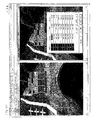
- Figs. 8 to 13 there are illustrated exemplary analyzing screens on the analyzing computer.
- an operator boots up a photo survey system software installed in the analyzing computer to load in the system the photographic image file for the geographic features to be surveyed (see Fig. 8, geographic features 54), which has been sent from the customer, according to a command selected from a menu screen (see Fig. 9, a menu screen 52).
- the operator carries out image processing or manual operation to prepare data about each station at the area under survey (see Fig. 10, a screen 56 on which analyzing input data are prepared), and performs computation processing to obtain the three-dimensional coordinate information on each station in the form of numerical data (see Fig. 11, a screen 58 indicating the analytical results).
- the operator uses the numerical data to prepare a three-dimensional or stereoscopic coordinate view or CAD view by computation processing (graphic processing) (see Fig. 12, a screen 60 with the analytical results displayed thereon, and Fig. 13, a screen 62 with the results of photo surveying displayed thereon).
- the file containing a plurality of photographic images already sent from the customer is read and opened in the analyzing computer by an operator on the computer terminal equipment side (step 110).
- the operator enters in the computer various conditions such as unknowns, viz., the number of images, the number of stations, the number of reference points, the number of length information, the number of repetitive calculations, etc., so that the computer can prepare a plurality of conditions for computation processing (step 112).
- this reference point may be appropriately determined by allowing the customer to indicate a specific station.
- the operator enters in the computer an object distance (initial value) and the focal length of the camera (initial value) (step 116).
- the operator performs image processing, manual operations or the like to obtain a two-dimensional coordinate position on each photographic image with respect to the reference point in each of the aforesaid plurality of photographic images (step 118).
- the operator enters the photographing position (initial value) and the photographing angle (initial value) in the computer (step 120), and subsequently enters the three-dimensional coordinates of each station (initial value) therein (step 122).
- the foregoing operations are carried out so that matching for the station on each image can be executed by computation processing (step 124).
- This enables the station at the area under survey to be extracted by image processing, etc. from each photographic image and matching for associated stations between the photographic images to be performed by computation processing, so that the three-dimensional position information on each station, viz., the coordinate value of each station on the basis of any point and direction in the space under survey can be calculated.
- the direction (direction vector) of a surface defined by three or more adjacent stations is calculated.
- the photographic image for the station per image is obtained by image processing or the like (step 126).
- the length information within the space under survey is entered by the operator in the computer (step 128).
- the numbers of the stations defining the surface to be calculated are finally entered in the computer (step 130).
- step 114 through step 130 the direction (direction vector) of the surface defined by three or more adjacent stations is calculated so that, for instance, CAD views can be prepared.
- initial value entered for the aforesaid series of operations and processing is intended an initial value for repetitive analysis calculations, and so this initial value may be a rough value.
- the aforesaid series of operations make it possible to automate the operations for performing matching for station per image and obtaining photographic coordinates, which have so far be manually carried out by an operator.
- the latter part of the aforesaid series of operations and processing viz., the step 122 for entry of the three-dimensional coordinates of each station to the step 130 may be carried out according to such a process as shown in Fig. 15.
- the photographic coordinates of a station on a certain image is obtained by image processing (step 132)
- the three-dimensional coordinates (initial value) of the station are calculated by computation processing (step 134) to perform station matching per image (step 136)
- the two-dimensional coordinate position on the photograph of each station in other images is obtained by image processing or the like (step 138).
- the length information within the space under survey is entered by the operator (step 140), followed by entry of the numbers of stations defining the surface to be calculated (step 142).
- Fig. 16 is illustrative of how to evaluate photographs.
- the position coordinates and direction of a camera, the focal length of the camera, the principal point shift of the camera, the distortions of the camera, etc. should be taken into account.
- photographs taken using one camera with its focal length fixed may all be regarded as having the same internal evaluation element.
- the following collinear conditions are derived from projection relations from the three-dimensional coordinates (X, Y, Z) of a subject space onto measurements (Xi, Yi) of two dimensional-coordinates on a photographic image (i).
- Ci is the focal length of the camera
- six evaluation elements (X0i, Y0i, Z0i, ⁇ i, ⁇ i, ⁇ i) represent the coordinates and inclination of the camera projection center).
- the coordinates (x, y) of a photographic image P are represented as below from a survey coordinate system (xc, yc), a photographic coordinate system (xh, yh) and a lens distortion ( ⁇ x, ⁇ y).
- k1, k2, k3, p1 and p2 are coefficients with respect to the lens distortion
- eight evaluation elements ci, Hhi, Yhi, kli, k2i, k3i, pli and p2i are coefficients with respect to the focal length of the camera, the principal point shifts of the camera and the lens distortion.
- xij xcij - xhi - ⁇ xij
- yij yij(k1irij 2 +k2irij 4 +k3irij 6 )+2p1ixijyij+2pi(rij 2 +2yij 2 )
- rij 2 xij 2 + yij 2
- the conditions are formulated for the use of the aforesaid non-survey camera so that the camera lens can be analytically corrected for distortions, etc. For this reason, it is unnecessary for the customer to use a dedicated camera for the purpose of taking digital photographs; commercially available digital cameras can be used, resulting in some consideration reductions of equipment costs.
- image processing can be carried out for analysis processing to extract the respective stations in an automated manner.
- the stations are detected by image processing from the color densities on the photographic image to automatically determine the relation between thresholds and pixel coordinates or the coordinates (barycentric coordinates) of the stations, as shown in Fig. 17.
- stations for photo surveying may be provided by fixing reflective boards or blocks by means of anchors, pegs or the like.
- ⁇ stand for the positions of stations
- the rectangular frame represents the range where each photographic image is obtained
- the " ⁇ - ⁇ ” indicates information on known length.
- the photo survey service system is applicable to the computerization of a tunnel.
- this photo survey system may be used to measure displacements in the internal space at the time of excavation.
- the system of this embodiment is used to measure displacements in the internal space at the time of excavation for inverse analysis, thereby making it possible to calculate distortions in the ground in the vicinity of the tunnel, the stress of sprayed concrete and the axial force of rock bolts generated.
- a plurality of photographic images obtained at varied angles and positions in the tunnel during excavation may be used. In this case, however, flash shots of stations with reflective seals put thereon are taken to calculate the three-dimensional coordinates of each station.
- the aforesaid series of image or analytical processing steps may be performed either by an analyzing computer installed at the site of the photo survey service firm which has received an order for analyzing operations or an analyzing computer installed at the site of an analysis service firm to which the data to be analyzed have been outsourced from the photo survey service firm.
- the results of the image processing and computation processing performed by the analyzing computer viz., the table indicative of the three-dimensional coordinates of each station at the surveyed area such as one shown in Fig. 18, the CAD data on the surveyed area, etc. are e-mailed from the Internet terminal equipment on the photo survey service firm side to terminal equipment on the customer side. In this way, the results of photo surveying are delivered to the customer.
- the photo survey service system of the invention it is possible for the customer to obtain the end outcome of photo surveying through simple administrative work on short lead times yet at low cost. What should be carried out for this purpose on the customer side is only to take photographs of the area to be surveyed using a commercially available digital camera, etc. and send them to the photo survey service firm by means of e-mail, etc. on the Internet. Then, the photo survey service firm may use its own analyzing computer to analyze the photographic data, thereby obtaining the end outcome of photo surveying or the results of analyzing the surveyed area in the form of numerical data or three-dimensional CAD views or the like. Finally, the photo survey service firm e-mails or otherwise delivers such data or views to the customer via the Internet.
Abstract
Description
an analyzer data base 32 wherein e-mail addresses of analyzers having the necessary analyzing expertise and information concerning their analyzing capabilities are registered,
an analyzer retrieval means 34 for performing matching for the photographing conditions for an image received by said image information receiving means 12 and the information concerning the analyzing capabilities registered in said data base 32 to find the best analyzer from said data base 32,
an analytical result transmitting means 34 for e-mailing the image information received by said image information receiving means 12 to terminal equipment 34 for the thus found analyzer via the Internet 22, and
an analytical result receiving means 40 for receiving, in addition to information on the three-dimensional vector relation and/or position of each station calculated by the analysis processing means 14 on the thus found analyzer side, graphic information subjected to graphic processing by said graphic processing means 18 from the terminal equipment 36 on the thus found analyzer side via the Internet 22.


Claims (5)
- A photo survey service system comprising:an image information receiving means 12 for receiving image information from customer's terminal equipment 8 via a telecommunication circuit network 10, said image information being obtained by taking photographs of an area 4 under survey having a plurality of stations 2-1, 2-2, ··· 2-n from a plurality of points using a digital camera 6 at a fixed focal length,an analysis processing means 14 which uses computation processing to calculate a three-dimensional vector relation of each station from the received image information on the basis of a difference in parallax between both images of adjacent photographing points, andan analytical result transmitting means 16 for transmitting information on the calculated three-dimensional vector relation of each station to the customer's terminal equipment 8 via the telecommunication circuit network 10.
- A photo survey service system comprising:an image information receiving means 12 for receiving image information obtained by taking photographs of an area 4 under survey having a plurality of stations 2-1, 2-2, ··· 2-n from a plurality of points using a digital camera 6 at a fixed focal length and length information in the area 4 under survey from customer's terminal equipment 8 via a telecommunication circuit network 10,an analysis processing means 14 which uses computation processing to calculate a three-dimensional position of each station from the received image information and the received length information in the area 4 under survey on the basis of a difference in parallax between both images of adjacent photographing points, andan analytical result transmitting means 16 for transmitting information on the calculated three-dimensional position of each station to the customer's terminal equipment 8 via the telecommunication circuit network 10.
- The photo survey service system according to claim 1 or 2, which further includes a graphic processing means 18 for performing graphic processing on the basis of information concerning the three-dimensional vector relation or position of each station calculated by said analysis processing means 14, and wherein said analytical result transmitting means 16 is operable to transmit, in addition to the information concerning the calculated three-dimensional vector relation or position of each station, graphic information obtained from said graphic processing means to the customer's terminal equipment 8 via the telecommunication circuit network 10.
- The photo survey service system according to any one of claims 1 to 3, which further includes:an estimate condition input means 24 for receiving entry of at least information concerning the number of photographs and the total number of stations that are conditions for photo surveying and an output form of photo survey results from terminal equipment 20 for a person or customer gaining access to a generally browsable web site on the Internet 22,an estimate display means 26 for calculating an estimate for photo surveying on the basis of the entered conditions and displaying said estimate on a browsable screen of the terminal equipment 20 for said access person,an order intake means 28 for receiving, in a screen, entry of information for identification of said access person including her or his e-mail address and information for confirmation of an order, and for receiving an order under the entered conditions upon entry of said information by the terminal equipment 20 for said person via the Internet 22, anda means 30 for instructing how to photograph whereby, when said order is received, a text file containing information about how to take survey photographs under said entered conditions is e-mailed to the terminal equipment 20 on the access person side via the Internet 22.
- The photo survey service system according to any one of claims 1 to 4, which comprises, in addition to said analysis processing means 14 or said analysis processing means 14 and said graphic processing means 18,
an analyzer data base 32 wherein e-mail addresses of analyzers having the necessary analyzing expertise and information concerning their analyzing capabilities are registered,
an analyzer retrieval means 34 for performing matching for the photographing conditions for an image received by said image information receiving means 12 and the information concerning the analyzing capabilities registered in said data base 32 to find the best analyzer from said data base 32,
an analytical result transmitting means 34 for e-mailing the image information received by said image information receiving means 12 to terminal equipment 34 for the thus found analyzer via the Internet 22, and
an analytical result receiving means 40 for receiving, in addition to information on the three-dimensional vector relation and/or position of each station calculated by the analysis processing means 14 on the thus found analyzer side, graphic information subjected to graphic processing by said graphic processing means 18 from the terminal equipment 36 on the thus found analyzer side via the Internet 22.
Applications Claiming Priority (2)
| Application Number | Priority Date | Filing Date | Title |
|---|---|---|---|
| JP2000381509A JP4145484B2 (en) | 2000-12-15 | 2000-12-15 | Photogrammetry service system |
| JP2000381509 | 2000-12-15 |
Publications (3)
| Publication Number | Publication Date |
|---|---|
| EP1215467A2 true EP1215467A2 (en) | 2002-06-19 |
| EP1215467A3 EP1215467A3 (en) | 2003-12-03 |
| EP1215467B1 EP1215467B1 (en) | 2006-08-23 |
Family
ID=18849488
Family Applications (1)
| Application Number | Title | Priority Date | Filing Date |
|---|---|---|---|
| EP01109065A Expired - Lifetime EP1215467B1 (en) | 2000-12-15 | 2001-04-11 | Photo survey service system |
Country Status (4)
| Country | Link |
|---|---|
| US (1) | US7023468B2 (en) |
| EP (1) | EP1215467B1 (en) |
| JP (1) | JP4145484B2 (en) |
| DE (1) | DE60122459T2 (en) |
Cited By (1)
| Publication number | Priority date | Publication date | Assignee | Title |
|---|---|---|---|---|
| CN111047964A (en) * | 2019-12-16 | 2020-04-21 | 北京工业大学 | Experimental device for be used for building space and interior portion article size coordination |
Families Citing this family (12)
| Publication number | Priority date | Publication date | Assignee | Title |
|---|---|---|---|---|
| JP4696407B2 (en) * | 2001-06-20 | 2011-06-08 | 株式会社ニコン | Product recommendation system and product recommendation method |
| KR100617702B1 (en) * | 2004-01-13 | 2006-08-28 | 삼성전자주식회사 | Portable terminal capable of editing image and image edition method using that |
| US20060089839A1 (en) * | 2004-10-21 | 2006-04-27 | Smiley Donna S | Enhanced customer design visual integration (ECDVI) |
| US7805066B2 (en) * | 2007-12-24 | 2010-09-28 | Microsoft Corporation | System for guided photography based on image capturing device rendered user recommendations according to embodiments |
| US9570892B2 (en) * | 2009-07-21 | 2017-02-14 | Cantega Technologies Inc. | Photogrammetric methods and apparatus for measurement of electrical equipment |
| JP5097765B2 (en) * | 2009-12-14 | 2012-12-12 | 株式会社ネクスコ東日本エンジニアリング | Measuring method, measuring program and measuring device |
| WO2011149558A2 (en) | 2010-05-28 | 2011-12-01 | Abelow Daniel H | Reality alternate |
| CN104374373A (en) * | 2014-10-15 | 2015-02-25 | 中铁电气化局集团有限公司 | Catenary status monitoring system based on pantograph image analysis |
| KR101603227B1 (en) * | 2014-10-24 | 2016-03-15 | 트라이콤텍 주식회사 | Information providing method for indoor area by using the immersive media's video data based on 360 degree |
| CN111754185A (en) * | 2019-03-29 | 2020-10-09 | 北京金风科创风电设备有限公司 | Wind power plant survey data processing system, method, equipment and storage medium |
| US11536857B2 (en) | 2019-12-19 | 2022-12-27 | Trimble Inc. | Surface tracking on a survey pole |
| US11175134B2 (en) * | 2019-12-19 | 2021-11-16 | Trimble Inc. | Surface tracking with multiple cameras on a pole |
Family Cites Families (9)
| Publication number | Priority date | Publication date | Assignee | Title |
|---|---|---|---|---|
| NL8503378A (en) * | 1985-12-06 | 1987-07-01 | Theo Jogchum Poelstra | NEW METHOD FOR BUILDING AND TRACKING DATA FILES FOR ROAD TRAFFIC. |
| US5220441A (en) * | 1990-09-28 | 1993-06-15 | Eastman Kodak Company | Mechanism for determining parallax between digital images |
| US5214281A (en) * | 1992-03-20 | 1993-05-25 | Rowe Douglas J | Method for locating sub-terranean geological aggregate deposits |
| JPH11509064A (en) * | 1995-07-10 | 1999-08-03 | サーノフ コーポレイション | Methods and systems for representing and combining images |
| US5818951A (en) * | 1995-10-13 | 1998-10-06 | Infrared Service Corporation | Methods and related apparatus for generating thermographic survey images |
| US5806005A (en) * | 1996-05-10 | 1998-09-08 | Ricoh Company, Ltd. | Wireless image transfer from a digital still video camera to a networked computer |
| US6385772B1 (en) * | 1998-04-30 | 2002-05-07 | Texas Instruments Incorporated | Monitoring system having wireless remote viewing and control |
| US6392692B1 (en) * | 1999-02-25 | 2002-05-21 | David A. Monroe | Network communication techniques for security surveillance and safety system |
| US6587601B1 (en) * | 1999-06-29 | 2003-07-01 | Sarnoff Corporation | Method and apparatus for performing geo-spatial registration using a Euclidean representation |
-
2000
- 2000-12-15 JP JP2000381509A patent/JP4145484B2/en not_active Expired - Fee Related
-
2001
- 2001-04-11 EP EP01109065A patent/EP1215467B1/en not_active Expired - Lifetime
- 2001-04-11 DE DE60122459T patent/DE60122459T2/en not_active Expired - Lifetime
- 2001-05-22 US US09/861,630 patent/US7023468B2/en not_active Expired - Fee Related
Non-Patent Citations (1)
| Title |
|---|
| DRAP P ET AL: "A digital photogrammetric workstation on the WEB" ISPRS JOURNAL OF PHOTOGRAMMETRY AND REMOTE SENSING, FEB. 2000, ELSEVIER, NETHERLANDS, vol. 55, no. 1, February 2000 (2000-02), pages 48-58, XP002255708 ISSN: 0924-2716 * |
Cited By (2)
| Publication number | Priority date | Publication date | Assignee | Title |
|---|---|---|---|---|
| CN111047964A (en) * | 2019-12-16 | 2020-04-21 | 北京工业大学 | Experimental device for be used for building space and interior portion article size coordination |
| CN111047964B (en) * | 2019-12-16 | 2021-11-16 | 北京工业大学 | Experimental device for be used for building space and interior portion article size coordination |
Also Published As
| Publication number | Publication date |
|---|---|
| DE60122459D1 (en) | 2006-10-05 |
| JP4145484B2 (en) | 2008-09-03 |
| DE60122459T2 (en) | 2007-02-22 |
| US20020146164A1 (en) | 2002-10-10 |
| EP1215467A3 (en) | 2003-12-03 |
| EP1215467B1 (en) | 2006-08-23 |
| JP2002181536A (en) | 2002-06-26 |
| US7023468B2 (en) | 2006-04-04 |
Similar Documents
| Publication | Publication Date | Title |
|---|---|---|
| US10825198B2 (en) | 3 dimensional coordinates calculating apparatus, 3 dimensional coordinates calculating method, 3 dimensional distance measuring apparatus and 3 dimensional distance measuring method using images | |
| KR100473331B1 (en) | Mobile Mapping System and treating method thereof | |
| EP1215467B1 (en) | Photo survey service system | |
| Golparvar-Fard et al. | Evaluation of image-based modeling and laser scanning accuracy for emerging automated performance monitoring techniques | |
| EP1607718B1 (en) | Surveying instrument and electronic storage medium | |
| EP1655573B1 (en) | 3-dimensional measurement device and electronic storage medium | |
| US9552669B2 (en) | System, apparatus, and method for utilizing geographic information systems | |
| US20030103651A1 (en) | Photogrammetric apparatus | |
| US20030004645A1 (en) | Image measurement and display device, image measurement and display system, construction management method, and construction status monitor system | |
| US10467726B2 (en) | Post capture imagery processing and deployment systems | |
| Dai et al. | Photogrammetry assisted measurement of interstory drift for rapid post-disaster building damage reconnaissance | |
| KR100822814B1 (en) | Method for overlapping real-time landscape image and gis data | |
| Carvajal-Ramírez et al. | Effects of image orientation and ground control points distribution on unmanned aerial vehicle photogrammetry projects on a road cut slope | |
| Mora et al. | Accuracy of stockpile estimates using low-cost sUAS photogrammetry | |
| CN111750838B (en) | Method, device and equipment for generating agricultural land planning map and storage medium | |
| US20230281737A1 (en) | Property measurement with automated document production | |
| Arias et al. | 3D modeling and section properties of ancient irregular timber structures by means of digital photogrammetry | |
| Lee et al. | A prototype of digital photogrammetric algorithm for estimating roughness of rock surface | |
| Subramanian et al. | Using 360-Degree Panoramic Photogrammetry and Laser Scanning Techniques to Create Point Cloud Data: A Comparative Pilot Study | |
| Stylianidis et al. | A digital close-range photogrammetric technique for monitoring slope displacements | |
| Forlani et al. | Production of high-resolution digital terrain models in mountain regions to support risk assessment | |
| Ordóñez et al. | A software program for semi-automated measurement of building facades | |
| Baramsyah et al. | Applicability Assessments of Close-Range Photogrammetry for Slope Face 3D Modelling | |
| KR102651035B1 (en) | Method For Surveying | |
| Broome et al. | Faculty of Health, Engineering and Sciences |
Legal Events
| Date | Code | Title | Description |
|---|---|---|---|
| PUAI | Public reference made under article 153(3) epc to a published international application that has entered the european phase |
Free format text: ORIGINAL CODE: 0009012 |
|
| 17P | Request for examination filed |
Effective date: 20011026 |
|
| AK | Designated contracting states |
Kind code of ref document: A2 Designated state(s): AT BE CH CY DE DK ES FI FR GB GR IE IT LI LU MC NL PT SE TR |
|
| AX | Request for extension of the european patent |
Free format text: AL;LT;LV;MK;RO;SI |
|
| PUAL | Search report despatched |
Free format text: ORIGINAL CODE: 0009013 |
|
| RIC1 | Information provided on ipc code assigned before grant |
Ipc: 7G 01C 11/06 A Ipc: 7G 06T 7/00 B |
|
| AK | Designated contracting states |
Kind code of ref document: A3 Designated state(s): AT BE CH CY DE DK ES FI FR GB GR IE IT LI LU MC NL PT SE TR |
|
| AX | Request for extension of the european patent |
Extension state: AL LT LV MK RO SI |
|
| 17Q | First examination report despatched |
Effective date: 20040326 |
|
| AKX | Designation fees paid |
Designated state(s): DE FR GB IT |
|
| GRAP | Despatch of communication of intention to grant a patent |
Free format text: ORIGINAL CODE: EPIDOSNIGR1 |
|
| GRAS | Grant fee paid |
Free format text: ORIGINAL CODE: EPIDOSNIGR3 |
|
| GRAA | (expected) grant |
Free format text: ORIGINAL CODE: 0009210 |
|
| AK | Designated contracting states |
Kind code of ref document: B1 Designated state(s): DE FR GB IT |
|
| PG25 | Lapsed in a contracting state [announced via postgrant information from national office to epo] |
Ref country code: IT Free format text: LAPSE BECAUSE OF FAILURE TO SUBMIT A TRANSLATION OF THE DESCRIPTION OR TO PAY THE FEE WITHIN THE PRESCRIBED TIME-LIMIT;WARNING: LAPSES OF ITALIAN PATENTS WITH EFFECTIVE DATE BEFORE 2007 MAY HAVE OCCURRED AT ANY TIME BEFORE 2007. THE CORRECT EFFECTIVE DATE MAY BE DIFFERENT FROM THE ONE RECORDED. Effective date: 20060823 |
|
| REG | Reference to a national code |
Ref country code: GB Ref legal event code: FG4D |
|
| REF | Corresponds to: |
Ref document number: 60122459 Country of ref document: DE Date of ref document: 20061005 Kind code of ref document: P |
|
| ET | Fr: translation filed | ||
| PLBE | No opposition filed within time limit |
Free format text: ORIGINAL CODE: 0009261 |
|
| STAA | Information on the status of an ep patent application or granted ep patent |
Free format text: STATUS: NO OPPOSITION FILED WITHIN TIME LIMIT |
|
| 26N | No opposition filed |
Effective date: 20070524 |
|
| PGFP | Annual fee paid to national office [announced via postgrant information from national office to epo] |
Ref country code: DE Payment date: 20120403 Year of fee payment: 12 |
|
| PGFP | Annual fee paid to national office [announced via postgrant information from national office to epo] |
Ref country code: GB Payment date: 20120423 Year of fee payment: 12 Ref country code: FR Payment date: 20120511 Year of fee payment: 12 |
|
| PGFP | Annual fee paid to national office [announced via postgrant information from national office to epo] |
Ref country code: IT Payment date: 20120423 Year of fee payment: 12 |
|
| GBPC | Gb: european patent ceased through non-payment of renewal fee |
Effective date: 20130411 |
|
| PG25 | Lapsed in a contracting state [announced via postgrant information from national office to epo] |
Ref country code: GB Free format text: LAPSE BECAUSE OF NON-PAYMENT OF DUE FEES Effective date: 20130411 Ref country code: DE Free format text: LAPSE BECAUSE OF NON-PAYMENT OF DUE FEES Effective date: 20131101 |
|
| REG | Reference to a national code |
Ref country code: FR Ref legal event code: ST Effective date: 20131231 |
|
| REG | Reference to a national code |
Ref country code: DE Ref legal event code: R119 Ref document number: 60122459 Country of ref document: DE Effective date: 20131101 |
|
| PG25 | Lapsed in a contracting state [announced via postgrant information from national office to epo] |
Ref country code: IT Free format text: LAPSE BECAUSE OF NON-PAYMENT OF DUE FEES Effective date: 20130411 Ref country code: FR Free format text: LAPSE BECAUSE OF NON-PAYMENT OF DUE FEES Effective date: 20130430 |