US7764231B1 - Wireless location using multiple mobile station location techniques - Google Patents
Wireless location using multiple mobile station location techniques Download PDFInfo
- Publication number
- US7764231B1 US7764231B1 US09/194,367 US19436797A US7764231B1 US 7764231 B1 US7764231 B1 US 7764231B1 US 19436797 A US19436797 A US 19436797A US 7764231 B1 US7764231 B1 US 7764231B1
- Authority
- US
- United States
- Prior art keywords
- location
- mobile station
- information
- stations
- data
- Prior art date
- Legal status (The legal status is an assumption and is not a legal conclusion. Google has not performed a legal analysis and makes no representation as to the accuracy of the status listed.)
- Expired - Fee Related
Links
Images


Classifications
-
- H—ELECTRICITY
- H04—ELECTRIC COMMUNICATION TECHNIQUE
- H04W—WIRELESS COMMUNICATION NETWORKS
- H04W4/00—Services specially adapted for wireless communication networks; Facilities therefor
- H04W4/02—Services making use of location information
- H04W4/025—Services making use of location information using location based information parameters
-
- G—PHYSICS
- G01—MEASURING; TESTING
- G01S—RADIO DIRECTION-FINDING; RADIO NAVIGATION; DETERMINING DISTANCE OR VELOCITY BY USE OF RADIO WAVES; LOCATING OR PRESENCE-DETECTING BY USE OF THE REFLECTION OR RERADIATION OF RADIO WAVES; ANALOGOUS ARRANGEMENTS USING OTHER WAVES
- G01S1/00—Beacons or beacon systems transmitting signals having a characteristic or characteristics capable of being detected by non-directional receivers and defining directions, positions, or position lines fixed relatively to the beacon transmitters; Receivers co-operating therewith
- G01S1/02—Beacons or beacon systems transmitting signals having a characteristic or characteristics capable of being detected by non-directional receivers and defining directions, positions, or position lines fixed relatively to the beacon transmitters; Receivers co-operating therewith using radio waves
- G01S1/022—Means for monitoring or calibrating
- G01S1/026—Means for monitoring or calibrating of associated receivers
-
- G—PHYSICS
- G01—MEASURING; TESTING
- G01S—RADIO DIRECTION-FINDING; RADIO NAVIGATION; DETERMINING DISTANCE OR VELOCITY BY USE OF RADIO WAVES; LOCATING OR PRESENCE-DETECTING BY USE OF THE REFLECTION OR RERADIATION OF RADIO WAVES; ANALOGOUS ARRANGEMENTS USING OTHER WAVES
- G01S1/00—Beacons or beacon systems transmitting signals having a characteristic or characteristics capable of being detected by non-directional receivers and defining directions, positions, or position lines fixed relatively to the beacon transmitters; Receivers co-operating therewith
- G01S1/02—Beacons or beacon systems transmitting signals having a characteristic or characteristics capable of being detected by non-directional receivers and defining directions, positions, or position lines fixed relatively to the beacon transmitters; Receivers co-operating therewith using radio waves
- G01S1/022—Means for monitoring or calibrating
- G01S1/028—Simulation means, e.g. of beacon signals therefor
-
- G—PHYSICS
- G01—MEASURING; TESTING
- G01S—RADIO DIRECTION-FINDING; RADIO NAVIGATION; DETERMINING DISTANCE OR VELOCITY BY USE OF RADIO WAVES; LOCATING OR PRESENCE-DETECTING BY USE OF THE REFLECTION OR RERADIATION OF RADIO WAVES; ANALOGOUS ARRANGEMENTS USING OTHER WAVES
- G01S5/00—Position-fixing by co-ordinating two or more direction or position line determinations; Position-fixing by co-ordinating two or more distance determinations
- G01S5/0009—Transmission of position information to remote stations
- G01S5/0045—Transmission from base station to mobile station
- G01S5/0054—Transmission from base station to mobile station of actual mobile position, i.e. position calculation on base station
-
- G—PHYSICS
- G01—MEASURING; TESTING
- G01S—RADIO DIRECTION-FINDING; RADIO NAVIGATION; DETERMINING DISTANCE OR VELOCITY BY USE OF RADIO WAVES; LOCATING OR PRESENCE-DETECTING BY USE OF THE REFLECTION OR RERADIATION OF RADIO WAVES; ANALOGOUS ARRANGEMENTS USING OTHER WAVES
- G01S5/00—Position-fixing by co-ordinating two or more direction or position line determinations; Position-fixing by co-ordinating two or more distance determinations
- G01S5/02—Position-fixing by co-ordinating two or more direction or position line determinations; Position-fixing by co-ordinating two or more distance determinations using radio waves
- G01S5/0205—Details
- G01S5/021—Calibration, monitoring or correction
-
- G—PHYSICS
- G01—MEASURING; TESTING
- G01S—RADIO DIRECTION-FINDING; RADIO NAVIGATION; DETERMINING DISTANCE OR VELOCITY BY USE OF RADIO WAVES; LOCATING OR PRESENCE-DETECTING BY USE OF THE REFLECTION OR RERADIATION OF RADIO WAVES; ANALOGOUS ARRANGEMENTS USING OTHER WAVES
- G01S5/00—Position-fixing by co-ordinating two or more direction or position line determinations; Position-fixing by co-ordinating two or more distance determinations
- G01S5/02—Position-fixing by co-ordinating two or more direction or position line determinations; Position-fixing by co-ordinating two or more distance determinations using radio waves
- G01S5/0205—Details
- G01S5/0244—Accuracy or reliability of position solution or of measurements contributing thereto
-
- G—PHYSICS
- G01—MEASURING; TESTING
- G01S—RADIO DIRECTION-FINDING; RADIO NAVIGATION; DETERMINING DISTANCE OR VELOCITY BY USE OF RADIO WAVES; LOCATING OR PRESENCE-DETECTING BY USE OF THE REFLECTION OR RERADIATION OF RADIO WAVES; ANALOGOUS ARRANGEMENTS USING OTHER WAVES
- G01S5/00—Position-fixing by co-ordinating two or more direction or position line determinations; Position-fixing by co-ordinating two or more distance determinations
- G01S5/02—Position-fixing by co-ordinating two or more direction or position line determinations; Position-fixing by co-ordinating two or more distance determinations using radio waves
- G01S5/0257—Hybrid positioning
-
- G—PHYSICS
- G01—MEASURING; TESTING
- G01S—RADIO DIRECTION-FINDING; RADIO NAVIGATION; DETERMINING DISTANCE OR VELOCITY BY USE OF RADIO WAVES; LOCATING OR PRESENCE-DETECTING BY USE OF THE REFLECTION OR RERADIATION OF RADIO WAVES; ANALOGOUS ARRANGEMENTS USING OTHER WAVES
- G01S5/00—Position-fixing by co-ordinating two or more direction or position line determinations; Position-fixing by co-ordinating two or more distance determinations
- G01S5/02—Position-fixing by co-ordinating two or more direction or position line determinations; Position-fixing by co-ordinating two or more distance determinations using radio waves
- G01S5/0278—Position-fixing by co-ordinating two or more direction or position line determinations; Position-fixing by co-ordinating two or more distance determinations using radio waves involving statistical or probabilistic considerations
-
- H—ELECTRICITY
- H04—ELECTRIC COMMUNICATION TECHNIQUE
- H04W—WIRELESS COMMUNICATION NETWORKS
- H04W64/00—Locating users or terminals or network equipment for network management purposes, e.g. mobility management
-
- G—PHYSICS
- G01—MEASURING; TESTING
- G01S—RADIO DIRECTION-FINDING; RADIO NAVIGATION; DETERMINING DISTANCE OR VELOCITY BY USE OF RADIO WAVES; LOCATING OR PRESENCE-DETECTING BY USE OF THE REFLECTION OR RERADIATION OF RADIO WAVES; ANALOGOUS ARRANGEMENTS USING OTHER WAVES
- G01S2205/00—Position-fixing by co-ordinating two or more direction or position line determinations; Position-fixing by co-ordinating two or more distance determinations
- G01S2205/001—Transmission of position information to remote stations
- G01S2205/006—Transmission of position information to remote stations for emergency situations
-
- G—PHYSICS
- G01—MEASURING; TESTING
- G01S—RADIO DIRECTION-FINDING; RADIO NAVIGATION; DETERMINING DISTANCE OR VELOCITY BY USE OF RADIO WAVES; LOCATING OR PRESENCE-DETECTING BY USE OF THE REFLECTION OR RERADIATION OF RADIO WAVES; ANALOGOUS ARRANGEMENTS USING OTHER WAVES
- G01S2205/00—Position-fixing by co-ordinating two or more direction or position line determinations; Position-fixing by co-ordinating two or more distance determinations
- G01S2205/001—Transmission of position information to remote stations
- G01S2205/008—Transmission of position information to remote stations using a mobile telephone network
-
- G—PHYSICS
- G01—MEASURING; TESTING
- G01S—RADIO DIRECTION-FINDING; RADIO NAVIGATION; DETERMINING DISTANCE OR VELOCITY BY USE OF RADIO WAVES; LOCATING OR PRESENCE-DETECTING BY USE OF THE REFLECTION OR RERADIATION OF RADIO WAVES; ANALOGOUS ARRANGEMENTS USING OTHER WAVES
- G01S5/00—Position-fixing by co-ordinating two or more direction or position line determinations; Position-fixing by co-ordinating two or more distance determinations
- G01S5/0009—Transmission of position information to remote stations
- G01S5/0018—Transmission from mobile station to base station
-
- G—PHYSICS
- G01—MEASURING; TESTING
- G01S—RADIO DIRECTION-FINDING; RADIO NAVIGATION; DETERMINING DISTANCE OR VELOCITY BY USE OF RADIO WAVES; LOCATING OR PRESENCE-DETECTING BY USE OF THE REFLECTION OR RERADIATION OF RADIO WAVES; ANALOGOUS ARRANGEMENTS USING OTHER WAVES
- G01S5/00—Position-fixing by co-ordinating two or more direction or position line determinations; Position-fixing by co-ordinating two or more distance determinations
- G01S5/02—Position-fixing by co-ordinating two or more direction or position line determinations; Position-fixing by co-ordinating two or more distance determinations using radio waves
- G01S5/06—Position of source determined by co-ordinating a plurality of position lines defined by path-difference measurements
Definitions
- the present invention is directed generally to a system and method for locating people or objects, and in particular, to a system and method for locating a wireless mobile station using a plurality of simultaneously activated mobile station location estimators.
- Wireless communications systems are becoming increasingly important worldwide. Wireless cellular telecommunications systems are rapidly replacing conventional wire-based telecommunications systems in many applications.
- Cellular radio telephone networks (“CRT”) and specialized mobile radio-and mobile data radio networks are examples.
- CRT Cellular radio telephone networks
- the general principles of wireless cellular telephony have been described variously, for example in U.S. Pat. No. 5,295,180 to Vendetti, et al, which is incorporated herein by reference.
- GPS Global Positioning Satellite system
- a ground-based GPS receiver at or near the object to be located determines the difference between the time at which each satellite transmits a time signal and the time at which the signal is received and, based on the time differentials, determines the object's location.
- GPS is impractical in many applications.
- the signal power levels from the satellites are low and the GPS receiver requires a clear, line-of-sight path to at least three satellites above a horizon of about 60 degrees for effective operation. Accordingly, inclement weather conditions, such as clouds, terrain features, such as hills and trees, and buildings restrict the ability of the GPS receiver to determine its position. Furthermore, the initial GPS signal detection process for a GPS receiver is relatively long (i.e., several minutes) for determining the receiver's position. Such delays are unacceptable in many applications such as, for example, emergency response and vehicle tracking.
- Differential GPS, or DGPS systems offer correction schemes to account for time synchronization drift.
- Such correction schemes include the transmission of correction signals over a two-way radio link or broadcast via FM radio station subcarriers. These systems have been found to be awkward and have met with limited success.
- GPS-based location systems have been attempted in which the received GPS signals are transmitted to a central data center for performing location calculations. Such systems have also met with limited success.
- each of the various GPS embodiments have the same fundamental problems of limited reception of the satellite signals and added expense and complexity of the electronics required for an inexpensive location mobile station or handset for detecting and receiving the GPS signals from the satellites.
- Noise such as man-made externally sources (e.g., auto ignitions) and radio system co-channel and adjacent channel interference also affect radio reception and related performance measurements, such as the analog carrier-to-interference ratio (C/I), or digital energy-per-bit/Noise density ratio (E b/No ) and are particular to various points in time and space domains.
- C/I analog carrier-to-interference ratio
- E b/No digital energy-per-bit/Noise density ratio
- FIG. 1 illustrates a definition of channel types arising in communications:
- Frequencies between 1 GHz and 2 GHz experience increased values in the exponent, ranging from 2 to 4, or 20 to 40 dB/decade, which would be predicted for the new PCS 1.8-1.9 GHz band.
- the typical suburban model correction was found to be:
- d represents the distance between the mobile station (MS) and the base station (BS); P or represents the received power in free space) for a given set of unchanging environmental conditions, it may be possible to dynamically measure P or and then determine d.
- FIG. 2 provides a basis for the variables.
- a substantial difficulty with the two-ray model in practice is that it requires a substantial amount of data regarding building dimensions, geometries, street widths, antenna gain characteristics for every possible ray path, etc. Additionally, it requires an inordinate amount of computational resources and such a model is not easily updated or maintained.
- Greenstein studied the communication channels variable Bit-Error-Rate (BER) in a spatial domain, which was a departure from previous research that limited field measurements to the RF propagation channel signal strength alone.
- BER Bit-Error-Rate
- Greenstein based his finding on two suspicious assumptions: 1) he assumed that distance correlation estimates were identical for uplink and downlink transmission paths; and 2) modulation techniques would be transparent in terms of improved distance correlation conclusions. Although some data held very correlations, other data and environments produced poor results. Accordingly, his results appear unreliable for use in general location context.
- Greenstein et al, authored “A Measurement-Based Model for Predicting Coverage Areas of Urban Microcells”, in the IEEE Journal On Selected Areas in Communications, Vol. II, No. 7, 9/93.
- Greenstein reported a generic measurement-based model of RF attenuation in terms of constant-value contours surrounding a given low-power, low antenna microcell environment in a dense, rectilinear neighborhood, such as New York City. However, these contours were for the cellular frequency band. In this case, LOS and non-LOS clutter were considered for a given microcell site.
- the physical radio propagation channel perturbs signal strength, frequency (causing rate changes, phase delay, signal to noise ratios (e.g., C/I for the analog case, or E b/No , RF energy per bit, over average noise density ratio for the digital case) and Doppler-shift.
- Signal strength is usually characterized by:
- Loss due to slow fading includes shadowing due to clutter blockage (sometimes included in Lp).
- Fast fading is composed of multipath reflections which cause: 1) delay spread; 2) random phase shift or Rayleigh fading; and 3) random frequency modulation due to different Doppler shifts on different paths.
- L total L p +L slow +L fast
- FIG. 3 the figure illustrates key components of a typical cellular and PCS power budget design process.
- the cell designer increases the transmitted power P TX by the shadow fading margin L slow which is usually chosen to be within the 1-2 percentile of the slow fading probability density function (PDF) to minimize the probability of unsatisfactorily low received power level P RX at the receiver.
- the P RX level must have enough signal to noise energy level (e.g., 10 dB) to overcome the receiver's internal noise level (e.g., ⁇ 118 dBm in the case of cellular 0.9 GHz), for a minimum voice quality standard.
- P RX must never be below ⁇ 108 dBm, in order to maintain the quality standard.
- fast fading margin L fast which is typically also chosen to be a few percentiles of the fast fading distribution.
- the 1 to 2 percentiles compliment other network blockage guidelines.
- the cell base station traffic loading capacity and network transport facilities are usually designed for a 1-2 percentile blockage factor as well.
- both fading margins are simultaneously exceeded, thus causing a fading margin overload.
- Related objectives for various embodiments of the present invention include providing a system and method that:
- (1.2) can use the native electronics of typical commercially available, or likely to be available, telephony wireless mobile stations (e.g., handsets) as location devices;
- telephony wireless mobile stations e.g., handsets
- (1.3) can be used for effectively locating people and/or objects wherein there are few (if any) line-of-sight wireless receivers for receiving location signals from a mobile station (herein also denoted MS);
- MS mobile station
- (1.6) can substantially automatically adapt and/or (re)train and/or (re)calibrate itself according to changes in the environment and/or terrain of a geographical area where the present invention is utilized;
- (1.7) can utilize a plurality of wireless location estimators based on different wireless location technologies (e.g., GPS location techniques, terrestrial base station signal timing techniques for triangulation and/or trilateration, wireless signal angle of arrival location techniques, techniques for determining a wireless location within a building, techniques for determining a mobile station location using wireless location data collected from the wireless coverage area for, e.g., location techniques using base station signal coverage areas, signal pattern matching location techniques and/or stochastic techniques), wherein each such estimator may be activated independently of one another, whenever suitable data is provided thereto and/or certain conditions, e.g., specific to the estimator are met; (1.8) can provide a common interface module from which a plurality of the location estimators can be activated and/or provided with input; (1.9) provides resulting mobile station location estimates to location requesting applications (e.g., for 911 emergency, the fire or police departments, taxi services, vehicle location, etc.) via an output gateway, wherein this gateway:
- location requesting applications e.g.,
- Yet another objective is to provide a low cost location system and method, adaptable to wireless telephony systems, for using simultaneously a plurality of location techniques for synergistically increasing MS location accuracy and consistency.
- MS location techniques can be utilized by various embodiments of the present invention:
- adaptive wireless signal processing techniques having, for example, learning capabilities and including, for instance, artificial neural net and genetic algorithm processing;
- Yet another objective is to provide location estimates in terms of time vectors, which can be used to establish motion, speed, and an extrapolated next location in cases where the MS signal subsequently becomes unavailable.
- wireless herein is, in general, an abbreviation for “digital wireless”, and in particular, “wireless” refers to digital radio signaling using one of standard digital protocols such as CDMA, NAMPS, AMPS, TDMA and GSM, as one skilled in the art will understand.
- MS mobile station
- MS refers to a wireless device that is at least a transmitting device, and in most cases is also a wireless receiving device, such as a portable radio telephony handset. Note that in some contexts herein instead or in addition to MS, the following terms are also used: “personal station” (PS), and “location unit” (LU). In general, these terms may be considered synonymous.
- infrastructure denotes the network of telephony communication services, and more particularly, that portion of such a network that receives and processes wireless communications with wireless mobile stations.
- this infrastructure includes telephony wireless base stations (BS) such as those for radio mobile communication systems based on CDMA, AMPS, NAMPS, TDMA, and GSM wherein the base stations provide a network of cooperative communication channels with an air interface with the MS, and a conventional telecommunications interface with a Mobile Switch Center (MSC).
- BS telephony wireless base stations
- AMPS AMPS
- NAMPS NAMPS
- TDMA Time Division Multiple Access
- GSM Mobile Switch Center
- an MS user within an area serviced by the base stations may be provided with wireless communication throughout the area by user transparent communication transfers (i.e., “handoffs”) between the user's MS and these base stations in order to maintain effective telephony service.
- the mobile switch center provides communications and control connectivity among base stations and the public telephone network 124 .
- composite wireless signal characteristic values denotes the result of aggregating and filtering a collection of measurements of wireless signal samples, wherein these samples are obtained from the wireless communication between an MS to be located and the base station infrastructure (e.g., a plurality of networked base stations).
- the base station infrastructure e.g., a plurality of networked base stations.
- other phrases are also used herein to denote this collection of derived characteristic values depending on the context and the likely orientation of the reader.
- the phrase typically used is: “RF signal measurements”.
- location signature cluster and “location signal data” are used to describe signal characteristic values between the MS and the plurality of infrastructure base stations substantially simultaneously detecting MS transmissions.
- location communications between an MS and the base station infrastructure typically include simultaneous communications with more than one base station, a related useful notion is that of a “location signature” which is the composite wireless signal characteristic values for signal samples between an MS to be located and a single base station.
- signal characteristic values or “signal characteristic data” are used when either or both a location signature(s) and/or a location signature cluster(s) are intended.
- the present invention relates to a wireless mobile station location system, and in particular, various subsystems related thereto such as a wireless location gateway, and the combining or hybriding of a plurality of wireless location techniques.
- this term refers to a communications network node whereat a plurality of location requests are received for locating various mobile stations from various sources (e.g., for E911 requests, for stolen vehicle location, for tracking of vehicles traveling cross country, etc.), and for each such request and the corresponding mobile station to be located, this node: (a) activates one or more wireless location estimators for locating the mobile station, (b) receives one or more location estimates of the mobile station from the location estimators, and (c) transmits a resulting location estimate(s) to, e.g., an application which made the request.
- this node activates one or more wireless location estimators for locating the mobile station, (b) receives one or more location estimates of the mobile station from the location estimators, and (c) transmits a resulting location estimate(s) to, e.g., an application which made the request.
- such a gateway typically will likely activate location estimators according to the particulars of each individual wireless location request, e.g., the availability of input data needed by particular location estimators. Additionally, such a gateway will typically have sufficiently well defined uniform interfaces so that such location estimators can be added and/or deleted to, e.g., provide different location estimators for performing wireless location different coverage areas.
- the present invention encompasses such wireless location gateways.
- the location gateway embodiments of the present invention may activate one or more of a plurality of location estimators depending on, e.g., (a) the availability of particular types of wireless location data for locating the mobile station, and (b) the location estimators accessible by the location gateway.
- a plurality of location estimators may be activated for locating the mobile station in a single location, or different ones of such location estimators may be activated to locate the mobile station at different locations.
- the location gateway of the present invention may have incorporated therein one or more of the location estimators, and/or may access geographically distributed location estimators via requests through a communications network such as the Internet.
- the location gateway of the present invention may access, in various instances of locating mobile stations, various location estimators that utilize one or more of the following wireless location techniques:
- some embodiments of the present invention may be viewed as platforms for integrating wireless location techniques in that wireless location computational models (denoted “first order models” or “FOMs” hereinbelow) may be added and/or deleted from such embodiments of the invention without changing the interface to further downstream processes. That is, one aspect of the invention is the specification of a common data interface between such computational models and subsequent location processing such as processes for combining of location estimates, tracking mobile stations, and/or outputting location estimates to location requesting applications.
- first order models denoted “first order models” or “FOMs” hereinbelow
- the present invention also encompasses various hybrid approaches to wireless location, wherein various combinations of two or more of the location techniques (a) through (g) immediately above may be used in locating a mobile station at substantially a single location.
- location information may be obtained from a plurality of the above location techniques for locating a mobile station, and the output from such techniques can be synergistically used for deriving therefrom an enhanced location estimate of the mobile station.
- a mobile station e.g., a truck traveling across country
- c for routing a mobile station
- locating people and/or animals including applications for confinement to (and/or exclusion from) certain areas.
- a first low level wireless signal processing subsystem for receiving, organizing and conditioning low level wireless signal measurements from a network of base stations cooperatively linked for providing wireless communications with mobile stations (MSs); and (ii) a second high level signal processing subsystem for performing high level data processing for providing most likelihood location estimates for mobile stations.
- the present invention may be considered as a novel signal processor that includes at least the functionality for the high signal processing subsystem mentioned hereinabove. Accordingly, assuming an appropriate ensemble of wireless signal measurements characterizing the wireless signal communications between a particular MS and a networked wireless base station infrastructure have been received and appropriately filtered of noise and transitory values (such as by an embodiment of the low level signal processing subsystem disclosed in a copending PCT patent application PCT/US97/15933 titled, “Wireless Location Using A Plurality of Commercial Network Infrastructures,” by F. W. LeBlanc et al., filed Sep. 8, 1997 from which U.S. Pat. No. 6,236,365, filed Jul. 8, 1999 is the U.S. national counterpart; these two references being herein fully incorporated by reference), the present invention uses the output from such a low level signal processing system for determining a most likely location estimate of an MS.
- the filtered and aggregated wireless signal characteristic values are provided to a number of location hypothesizing models (denoted First Order Models, or FOMs), each of which yields a location estimate or location hypothesis related to the location of the target MS.
- location hypotheses for both providing estimates of where the target MS is likely to be and where the target MS is not likely to be.
- confidence values of the location hypotheses are provided as a continuous range of real numbers from, e.g., ⁇ 1 to 1, wherein the most unlikely areas for locating the target MS are given a confidence value of ⁇ 1, and the most likely areas for locating the target MS are given a confidence value of 1.
- confidence values that are larger indicate a higher likelihood that the target MS is in the corresponding MS estimated area, wherein ⁇ 1 indicates that the target MS is absolutely NOT in the estimated area, 0 indicates a substantially neutral or unknown likelihood of the target MS being in the corresponding estimated area, and 1 indicates that the target MS is absolutely within the corresponding estimated area.
- the following capabilities are provided by the present invention:
- the present invention utilizes adaptive signal processing techniques.
- One particularly important utilization of such techniques includes the automatic tuning of the present invention so that, e.g., such tuning can be applied to adjusting the values of location processing system parameters that affect the processing performed by the present invention.
- location processing system parameters such system parameters as those used for determining the size of a geographical area to be specified when retrieving location signal data of known MS locations from the historical (location signature) data base can substantially affect the location processing.
- a system parameter specifying a minimum size for such a geographical area may, if too large, cause unnecessary inaccuracies in locating an MS.
- an adaptation engine is included in the present invention for automatically adjusting or tuning parameters used by the present invention.
- the adaptation engine is based on genetic algorithm techniques.
- a novel aspect of the present invention relies on the discovery that in many areas where MS location services are desired, the wireless signal measurements obtained from communications between the target MS and the base station infrastructure are extensive enough to provide sufficiently unique or peculiar values so that the pattern of values alone may identify the location of the target MS. Further, assuming a sufficient amount of such location identifying pattern information is captured in the composite wireless signal characteristic values for a target MS, and that there is a technique for matching such wireless signal patterns to geographical locations, then a FOM based on this technique may generate a reasonably accurate target MS location estimate.
- the present invention e.g., the location signature data base
- this captured data e.g., location signatures
- the present invention includes one or more FOMs that may be generally denoted as classification models wherein such FOMs are trained or calibrated to associate particular composite wireless signal characteristic values with a geographical location where a target MS could likely generate the wireless signal samples from which the composite wireless signal characteristic values are derived.
- the present invention includes the capability for training (calibrating) and retraining (recalibrating) such classification FOMs to automatically maintain the accuracy of these models even though substantial changes to the radio coverage area may occur, such as the construction of a new high rise building or seasonal variations (due to, for example, foliage variations).
- classification FOMs that are trained or calibrated to identify target MS locations by the wireless signal patterns produced constitute a particularly novel aspect of the present invention.
- TOA time-of-arrival
- TDOA time-difference-of-arrival
- this same multipath phenomenon also may produce substantially distinct or peculiar signal measurement patterns, wherein such a pattern coincides with a relatively small geographical area.
- the present invention utilizes multipath as an advantage for increasing accuracy where for previous location systems multipath has been a source of substantial inaccuracies.
- classification FOMs in high multipath environments is especially advantageous in that high multipath environments are typically densely populated.
- high multipath environments are typically densely populated.
- training or calibration data captured by the present invention for training or calibrating such classification FOMs and for progressively improving the MS location accuracy of such models.
- LBS location detection base stations
- a grid of such LBSs can be utilized for providing location signal data (from the built-in MS) for (re)training or (re)calibrating such classification FOMs.
- one or more classification FOMs may each include a learning module such as an artificial neural network (ANN) for associating target MS location signal data with a target MS location estimate.
- ANN artificial neural network
- one or more classification FOMs may be statistical prediction models based on such statistical techniques as, for example, principle decomposition, partial least squares, or other regression techniques.
- the personal communication system (PCS) infrastructures currently being developed by telecommunication providers offer an appropriate localized infrastructure base upon which to build various personal location systems (PLS) employing the present invention and/or utilizing the techniques disclosed herein.
- the present invention is especially suitable for the location of people and/or objects using code division multiple access (CDMA) wireless infrastructures, although other wireless infrastructures, such as, time division multiple access (TDMA) infrastructures and GSM are also contemplated.
- CDMA code division multiple access
- TDMA time division multiple access
- CDMA personal communications systems are described in the Telephone Industries Association standard IS-95, for frequencies below 1 GHz, and in the Wideband Spread-Spectrum Digital Cellular System Dual-Mode Mobile Station-Base Station Compatibility Standard, for frequencies in the 1.8-1.9 GHz frequency bands, both of which are incorporated herein by reference.
- CDMA general principles have also been described, for example, in U.S. Pat. No. 5,109,390, to Gilhausen, et al, filed Nov. 7, 1989, and CDMA Network Engineering Handbook by Qualcomm, Inc., each of which is also incorporated herein by reference.
- CDMA is an electromagnetic signal modulation and multiple access scheme based on spread spectrum communication.
- Each CDMA signal corresponds to an unambiguous pseudorandom binary sequence for modulating the carrier signal throughout a predetermined spectrum of bandwidth frequencies.
- Transmissions of individual CDMA signals are selected by correlation processing of a pseudonoise waveform.
- the CDMA signals are separately detected in a receiver by using a correlator, which accepts only signal energy from the selected binary sequence and despreads its spectrum.
- the transmissions of unrelated COMA signals correspond to pseudorandom sequences that do not match the first signal. Therefore, these other signals contribute only to the noise and represent a self-interference generated by the personal communications system.
- the present invention can substantially automatically retrain and/or recalibrate itself to compensate for variations in wireless signal characteristics (e.g., multipath) due to environmental and/or topographic changes to a geographic area serviced by the present invention.
- the present invention optionally includes low cost, low power base stations, denoted location base stations (LBS) above, providing, for example, CDMA pilot channels to a very limited area about each such LBS.
- LBS location base stations
- the location base stations may provide limited voice traffic capabilities, but each is capable of gathering sufficient wireless signal characteristics from an MS within the location base station's range to facilitate locating the MS.
- the location base stations by positioning the location base stations at known locations in a geographic region such as, for instance, on street lamp poles and road signs, additional MS location accuracy can be obtained. That is, due to the low power signal output by such location base stations, for there to be signaling control communication (e.g., pilot signaling and other control signals) between a location base station and a target MS, the MS must be relatively near the location base station. Additionally, for each location base station not in communication with the target MS, it is likely that the MS is not near to this location base station. Thus, by utilizing information received from both location base stations in communication with the target MS and those that are not in communication with the target MS, the present invention can substantially narrow the possible geographic areas within which the target MS is likely to be. Further, by providing each location base station (LBS) with a co-located stationary wireless transceiver (denoted a built-in MS above) having similar functionality to an MS, the following advantages are provided:
- the stationary transceiver can be signaled by another component(s) of the present invention to activate or deactivate its associated base station capability, thereby conserving power for the LBS that operate on a restricted power such as solar electrical power;
- the stationary transceiver of an LBS can be used for transferring target MS location information obtained by the LBS to a conventional telephony base station;
- the present invention is able to (re)train and/or (re)calibrate itself in geographical areas having such LBSs.
- wireless signal characteristic values for the location of the stationary transceiver are obtained for each such base station. Accordingly, such characteristic values can then be associated with the known location of the stationary transceiver for training and/or calibrating various of the location processing modules of the present invention such as the classification FOMs discussed above.
- training and/or calibrating may include:
- portable location verifying electronics are provided so that when such electronics are sufficiently near a located target MS, the electronics: (i) detect the proximity of the target MS; (ii) determine a highly reliable measurement of the location of the target MS; (iii) provide this measurement to other location determining components of the present invention so that the location measurement can be associated and archived with related signal characteristic data received from the target MS at the location where the location measurement is performed.
- the use of such portable location verifying electronics allows the present invention to capture and utilize signal characteristic data from verified, substantially random locations for location system calibration as in (6.3) above.
- location verifying electronics can verify locations automatically wherein it is unnecessary for manual activation of a location verifying process.
- One embodiment of the present invention includes the location verifying electronics as a “mobile (location) base station” (MBS) that can be, for example, incorporated into a vehicle, such as an ambulance, police car, or taxi.
- MBS mobile (location) base station
- Such a vehicle can travel to sites having a transmitting target MS, wherein such sites may be randomly located and the signal characteristic data from the transmitting target MS at such a location can consequently be archived with a verified location measurement performed at the site by the mobile location base station.
- a mobile location base station as its name implies also includes base station electronics for communicating with mobile stations, though not necessarily in the manner of a conventional infrastructure base station.
- a mobile location base station may only monitor signal characteristics, such as MS signal strength, from a target MS without transmitting signals to the target MS.
- a mobile location base station can periodically be in bi-directional communication with a target MS for determining a signal time-of-arrival (or time-difference-of-arrival) measurement between the mobile location base station and the target MS.
- each such mobile location base station includes components for estimating the location of the mobile location base station, such mobile location base station location estimates being important when the mobile location base station is used for locating a target MS via, for example, time-of-arrival or time-difference-of-arrival measurements as one skilled in the art will appreciate.
- a mobile location base station can include:
- a mobile station for both communicating with other components of the present invention (such as a location processing center included in the present invention);
- a mobile location base station includes modules for integrating or reconciling distinct mobile location base station location estimates that, for example, can be obtained using the components and devices of (7.1) through (7.4) above. That is, location estimates for the mobile location base station may be obtained from: GPS satellite data, mobile location base station data provided by the location processing center, deadreckoning data obtained from the mobile location base station vehicle deadreckoning devices, and location data manually input by an operator of the mobile location base station.
- the location system of the present invention readily benefits from the distinct advantages of the CDMA spread spectrum scheme, namely, these advantages include the exploitation of radio frequency spectral efficiency and isolation by (a) monitoring voice activity, (b) management of two-way power control, (c) provisioning of advanced variable-rate modems and error correcting signal encoding, (d) inherent resistance to fading, (e) enhanced privacy, and (f) multiple “rake” digital data receivers and searcher receivers for correlation of signal multipaths.
- hypotheses are:
- the models are embedded in the computational architecture in a manner wherein the architecture allows for substantial amounts of application specific processing common or generic to a plurality of the models to be straightforwardly incorporated into the computational architecture;
- the computational architecture enhances the hypotheses generated by the models both according to past performance of the models and according to application specific constraints and heuristics without requiring feedback loops for adjusting the models;
- (8.2) providing a computational paradigm for enhancing an initial estimated solution to a problem by using this initial estimated solution as, effectively, a query or index into an historical data base of previous solution estimates and corresponding actual solutions for deriving an enhanced solution estimate based on past performance of the module that generated the initial estimated solution.
- the novel computation architecture of the present invention can be utilized by (I) providing a plurality of document scanning models as the first order models, (ii) building a character recognition data base for archiving a correspondence between characteristics of actual printed character variations and the intended characters (according to, for example, font types), and additionally archiving a correspondence of performance of each of the models on previously encountered actual printed character variations (note, this is analogous to the Signature Data Base of the MS location application described herein), and (iii) determining any generic constraints and/or heuristics that are desirable to be satisfied by a plurality of the models.
- comparing outputs from the first order document scanning models a determination can be made as to whether further processing is desirable due to, for example, discrepancies between the output of the models. If further processing is desirable, then an embodiment of the multiple hypothesis architecture provided herein may be utilized to correct such discrepancies. Note that in comparing outputs from the first order document scanning models, these outputs may be compared at various granularities; e.g., character, sentence, paragraph or page;
- diagnosis and monitoring applications such as medical diagnosis/monitoring, communication network diagnosis/monitoring;
- this architecture need not have all modules co-located.
- various modules can be remotely located from one another and communicate with one another via telecommunication transmissions such as telephony technologies and/or the Internet.
- the present invention is particularly adaptable to such distributed computing environments. For example, some number of the first order models may reside in remote locations and communicate their generated hypotheses via the Internet.
- weather prediction hypotheses e.g., the likely path of a hurricane
- a site that performs hypothesis adjustments according to: (i) past performance of the each model; (ii) particular constraints and/or heuristics, and subsequently outputs a most likely estimate for a particular weather condition.
- the processing following the generation of location hypotheses (each having an initial location estimate) by the first order models may be such that this processing can be provided on Internet user nodes and the first order models may reside at Internet server sites.
- an Internet user may request hypotheses from such remote first order models and perform the remaining processing at his/her node.
- a fast, albeit less accurate location estimate may be initially performed for very time critical location applications where approximate location information may be required. For example, less than 1 second response for a mobile station location embodiment of the present invention may be desired for 911 emergency response location requests. Subsequently, once a relatively coarse location estimate has been provided, a more accurate most likely location estimate can be performed by repeating the location estimation processing a second time with, e.g., additional with, measurements of wireless signals transmitted between a mobile station to be located and a network of base stations with which the mobile station is communicating, thus providing a second, more accurate location estimate of the mobile station.
- central location development sites may be networked to, for example, geographically dispersed location centers providing location services according to the present invention, wherein the FOMs may be accessed, substituted, enhanced or removed dynamically via network connections (via, e.g., the Internet) with a central location development site.
- FOMs may be accessed, substituted, enhanced or removed dynamically via network connections (via, e.g., the Internet) with a central location development site.
- a small but rapidly growing municipality in substantially flat low density area might initially be provided with access to, for example, two or three FOMs for generating location hypotheses in the municipality's relatively uncluttered radio signaling environment.
- additional or alternative FOMs may be transferred via the network to the location center for the municipality.
- each FOM may be activated from an antecedent of an expert system rule.
- the antecedent for such a rule can evaluate to TRUE if the FOM outputs a location hypothesis, and the consequent portion of such a rule may put the output location hypothesis on a list of location hypotheses occurring in a particular time window for subsequent processing by the location center.
- activation of the FOMs may be in the consequents of such expert system rules. That is, the antecedent of such an expert system rule may determine if the conditions are appropriate for invoking the FOM(s) in the rule's consequent.
- FOMs may be object methods on an MS location estimator object, wherein the estimator object receives substantially all target MS location signal data output by the signal filtering subsystem.
- software bus architectures are contemplated by the present invention, as one skilled in the art will understand, wherein the software architecture may be modular and facilitate parallel processing.
- FIG. 1 illustrates various perspectives of radio propagation opportunities which may be considered in addressing correlation with mobile to base station ranging.
- FIG. 2 shows aspects of the two-ray radio propagation model and the effects of urban clutter.
- FIG. 3 provides a typical example of how the statistical power budget is calculated in design of a Commercial Mobile Radio Service Provider (CMRS) network.
- CMRS Commercial Mobile Radio Service Provider
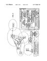
- FIG. 4 illustrates an overall view of a wireless radio location network architecture, based on AIN principles.
- FIG. 5 is a high level block diagram of an embodiment of the present invention for locating a mobile station (MS) within a radio coverage area for the present invention.
- FIG. 6 is a high level block diagram of the location center 142 .
- FIG. 7 is a high level block diagram of the hypothesis evaluator for the location center.
- FIG. 8 is a substantially comprehensive high level block diagram illustrating data and control flows between the components of the location center, as well the functionality of the components.
- FIGS. 9A and 9B is a high level data structure diagram describing the fields of a location hypothesis object generated by the first order models 1224 of the location center.
- FIG. 10 is a graphical illustration of the computation performed by the most likelihood estimator 1344 of the hypothesis evaluator.
- FIG. 11 is a high level block diagram of the mobile base station (MBS).
- FIG. 12 is a high level state transition diagram describing computational states the Mobile Base station enters during operation.
- FIG. 13 is a high level diagram illustrating the data structural organization of the Mobile Base station capability for autonomously determining a most likely MBS location from a plurality of potentially conflicting MBS location estimating sources.
- FIG. 14 shows one method of modeling CDMA delay spread measurement ensembles and interfacing such signals to a typical artificial neural network based FOM.
- FIG. 15 illustrates the nature of RF “Dead Zones”, notch area, and the importance of including location data signatures from the back side of radiating elements.
- FIGS. 16 a through 16 c present a table providing a brief description of the attributes of the location signature data type stored in the location signature data base 1320 .
- FIGS. 17 a through 17 c present a high level flowchart of the steps performed by function, “UPDATE_LOC_SIG_DB,” for updating location signatures in the location signature data base 1320 ; note, this flowchart corresponds to the description of this function in APPENDIX C.
- FIGS. 18 a through 18 b present a high level flowchart of the steps performed by function, “REDUCE_BAD_DB_LOC_SIGS,” for updating location signatures in the location signature data base 1320 ; note, this flowchart corresponds to the description of this function in APPENDIX C.
- FIGS. 19 a through 19 b present a high level flowchart of the steps performed by function, “INCREASE_CONFIDENCE_OF_GOOD_DB_LOC_SIGS,” for updating location signatures in the location signature data base 1320 ; note, this flowchart corresponds to the description of this function in APPENDIX C.
- FIGS. 20 a through 20 d present a high level flowchart of the steps performed by function, “DETERMINE_LOCATION_SIGNATURE_FIT_ERRORS,” for updating location signatures in the location signature data base 1320 ; note, this flowchart corresponds to the description of this function in APPENDIX C.
- FIG. 21 presents a high level flowchart of the steps performed by function, “ESTIMATE_LOC_SIG_FROM_DB,” for updating location signatures in the location signature data base 1320 ; note, this flowchart corresponds to the description of this function in APPENDIX C.
- FIGS. 22 a through 22 b present a high level flowchart of the steps performed by function, “GET_AREA_TO_SEARCH,” for updating location signatures in the location signature data base 1320 ; note, this flowchart corresponds to the description of this function in APPENDIX C.
- FIGS. 23A through 23C present a high level flowchart of the steps performed by function, “GET_DIFFERENCE_MEASUREMENT,” for updating location signatures in the location signature data base 1320 ; note, this flowchart corresponds to the description of this function in APPENDIX C.
- FIG. 24 is a high level illustration of context adjuster data structures and their relationship to the radio coverage area for the present invention.
- FIGS. 25 a through 25 b present a high level flowchart of the steps performed by the function, “CONTEXT_ADJUSTER,” used in the context adjuster 1326 for adjusting mobile station estimates provided by the first order models 1224 ; this flowchart corresponds to the description of this function in APPENDIX D.
- FIGS. 26 a through 26 c present a high level flowchart of the steps performed by the function, “GET_ADJUSTED_LOC_HYP_LIST_FOR,” used in the context adjuster 1326 for adjusting mobile station estimates provided by the first order models 1224 ; this flowchart corresponds to the description of this function in APPENDIX D.
- FIGS. 27 a through 27 b present a high level flowchart of the steps performed by the function, “CONFIDENCE_ADJUSTER,” used in the context adjuster 1326 for adjusting mobile station estimates provided by the first order models 1224 ; this flowchart corresponds to the description of this function in APPENDIX D.
- FIGS. 28 a and 28 b presents a high level flowchart of the steps performed by the function, “GET_COMPOSITE_PREDICTION_MAPPED_CLUSTER_DENSITY,” used in the context adjuster 1326 for adjusting mobile station estimates provided by the first order models 1224 ; this flowchart corresponds to the description of this function in APPENDIX D.
- FIGS. 29 a through 29 h present a high level flowchart of the steps performed by the function, “GET_PREDICTION_MAPPED_CLUSTER_DENSITY_FOR,” used in the context adjuster 1326 for adjusting mobile station estimates provided by the first order models 1224 ; this flowchart corresponds to the description of this function in APPENDIX D.
- FIG. 30 illustrates the primary components of the signal processing subsystem.
- FIG. 31 illustrates how automatic provisioning of mobile station information from multiple CMRS occurs.
- Various digital wireless communication standards have been introduced such as Advanced Mobile Phone Service (AMPS), Narrowband Advanced Mobile Phone Service (NAMPS), code division multiple access (CDMA) and Time Division Multiple Access (TDMA) (e.g., Global Systems Mobile (GSM).
- AMPS Advanced Mobile Phone Service
- NAMPS Narrowband Advanced Mobile Phone Service
- CDMA code division multiple access
- TDMA Time Division Multiple Access
- GSM Global Systems Mobile
- CDMA this standard is described in the Telephone Industries Association standard IS-95, for frequencies below 1 GHz, and in J-STD-008, the Wideband Spread-Spectrum Digital Cellular System Dual-Mode Mobile Station-Base station Compatibility Standard, for frequencies in the 1.8-1.9 GHz frequency bands.
- CDMA general principles have been described, for example, in U.S. Pat. No.
- CDMA radio technology exploits radio frequency spectral efficiency and isolation by monitoring voice activity, managing two-way power control, provision of advanced variable-rate modems and error correcting signal design, and includes inherent resistance to fading, enhanced privacy, and provides for multiple “rake” digital data receivers and searcher receivers for correlation of multiple physical propagation paths, resembling maximum likelihood detection, as well as support for multiple base station communication with a mobile station, i.e., soft or softer hand-off capability.
- a location center as described herein, substantial improvements in radio location can be achieved.
- the CDMA spread spectrum scheme exploits radio frequency spectral efficiency and isolation by monitoring voice activity, managing two-way power control, provision of advanced variable-rate modems and error correcting signal design, and includes inherent resistance to fading, enhanced privacy, and provides for multiple “rake” digital data receivers and searcher receivers for correlation of multiple physical propagation paths, resembling maximum likelihood detection, as well as support for multiple base station communication with a mobile station, i.e., soft hand-off capability.
- this same advanced radio communication infrastructure can also be used for enhanced radio location.
- the capabilities of IS-41 and AIN already provide a broad-granularity of wireless location, as is necessary to, for example, properly direct a terminating call to an MS.
- Such information can be re-used in conjunction with the location center described herein to provide wireless location in the large (i.e., to determine which country, state and city a particular MS is located) and wireless location in the small (i.e., which location, plus or minus a few hundred feet within one or more base stations a given MS is located).
- FIG. 4 is a high level diagram of a wireless digital radiolocation intelligent network architecture for the present invention. Accordingly, this figure illustrates the interconnections between the components, for example, of a typical PCS network configuration and various components that are specific to the present invention.
- a typical wireless (PCS) network includes:
- the present invention provides the following additional components:
- MBS mobile base stations 148
- LBS location base stations 152
- location base stations can be located on potentially each floor of a multi-story building
- the wireless location technology described herein can be used to perform location in terms of height as well as by latitude and longitude.
- the MS 140 may utilize one of the wireless technologies, CDMA, TDMA, AMPS, NAMPS or GSM techniques for radio communication with: (a) one or more infrastructure base stations 122 , (b) mobile base station(s) 148 , (c) an LBS 152 .
- base stations may be placed in any configuration, a typical deployment configuration is approximately in a cellular honeycomb pattern, although many practical tradeoffs exist, such as site availability, versus the requirement for maximal terrain coverage area.
- base stations three such exemplary base stations (BSs) are 122 A, 122 B and 122 C, each of which radiate referencing signals within their area of coverage 169 to facilitate mobile station (MS) 140 radio frequency connectivity, and various timing and synchronization functions.
- MS mobile station
- some base stations may contain no sectors 130 (e.g.
- base station 122 E thus radiating and receiving signals in a 360 degree omnidirectional coverage area pattern, or the base station may contain “smart antennas” which have specialized coverage area patterns.
- base station 122 A includes sectors 130 , additionally labeled a, b and c. Accordingly, each of the sectors 130 radiate and receive signals in an approximate 120 degree arc, from an overhead view.
- actual base station coverage areas 169 (stylistically represented by hexagons about the base stations 122 ) generally are designed to overlap to some extent, thus ensuring seamless coverage in a geographical area. Control electronics within each base station 122 are used to communicate with a mobile stations 140 .
- Information regarding the coverage area for each sector 130 may be known and used by the location center 142 to facilitate location determination. Further, during communication with a mobile station 140 , the identification of each base station 122 communicating with the MS 140 as well, as any sector identification information, may be known and provided to the location center 142 .
- a base station or mobility controller 174 controls, processes and provides an interface between originating and terminating telephone calls from/to mobile station (MS) 140 , and the mobile switch center (MSC) 112 .
- the MSC 122 on-the-other-hand, performs various administration to functions such as mobile station 140 registration, authentication and the relaying of various system parameters, as one skilled in the art will understand.
- the base stations 122 may be coupled by various transport facilities 176 such as leased lines, frame relay, T-Carrier links, optical fiber links or by microwave communication links.
- a mobile station 140 When a mobile station 140 (such as a CDMA, AMPS, NAMPS mobile telephone) is powered on and in the idle state, it constantly monitors the pilot signal transmissions from each of the base stations 122 located at nearby cell sites. Since base station/sector coverage areas may often overlap, such overlapping enables mobile stations 140 to detect, and, in the case of certain wireless technologies, communicate simultaneously along both the forward and reverse paths, with multiple base stations 122 and/or sectors 130 . In FIG. 4 the constantly radiating pilot signals from base station sectors 130 , such as sectors a, b and c of BS 122 A, are detectable by mobile stations 140 within the coverage area 169 for BS 122 A.
- base station sectors 130 such as sectors a, b and c of BS 122 A
- the mobile stations 140 scan for pilot channels, corresponding to a given base station/sector identifiers (IDs), for determining which coverage area 169 (i.e., cell) it is contained. This is performed by comparing signals strengths of pilot signals transmitted from these particular cell-sites.
- IDs base station/sector identifiers
- the mobile station 140 then initiates a registration request with the MSC 112 , via the base station controller 174 .
- the MSC 112 determines whether or not the mobile station 140 is allowed to proceed with the registration process (except in the case of a 911 call, wherein no registration process is required). At this point calls may be originated from the mobile station 140 or calls or short message service messages can be received from the network.
- the MSC 112 communicates as appropriate, with a class 4/5 wireline telephony circuit switch or other central offices, connected to the PSTN 124 network. Such central offices connect to wireline terminals, such as telephones, or any communication device compatible with the line.
- the PSTN 124 may also provide connections to long distance networks and other networks.
- the MSC 112 may also utilize IS/41 data circuits or trunks connecting to signal transfer point 110 , which in turn connects to a service control point 104 , via Signaling System #7 (SS7) signaling links (e.g., trunks) for intelligent call processing, as one skilled in the art will understand.
- SS7 Signaling System #7
- Such links are used for call routing instructions of calls interacting with the MSC 112 or any switch capable of providing service switching point functions, and the public switched telephone network (PSTN) 124 , with possible termination back to the wireless network.
- PSTN public switched telephone network
- the location center (LC) 142 interfaces with the MSC 112 either via dedicated transport facilities 178 , using for example, any number of LAN/WAN technologies, such as Ethernet, fast Ethernet, frame relay, virtual private networks, etc., or via the PSTN 124 .
- the LC 142 receives autonomous (e.g., unsolicited) command/response messages regarding, for example: (a) the state of the wireless network of each service provider, (b) MS 140 and BS 122 radio frequency (RF) measurements, (c) any MBSs 148 , (d) location applications requesting MS locations using the location center.
- the LC 142 provides data and control information to each of the above components in (a)-(d).
- the LC 142 may provide location information to an MS 140 , via a BS 122 .
- MBS mobile base station
- the MBS 148 acts as a low cost, partially-functional, moving base station, and is, in one embodiment, situated in a vehicle where an operator may engage in MS 140 searching and tracking activities. In providing these activities using CDMA, the MBS 148 provides a forward link pilot channel for a target MS 140 , and subsequently receives unique BS pilot strength measurements from the MS 140 .
- the MBS 148 also includes a mobile station for data communication with the LC 142 , via a BS 122 . In particular, such data communication includes telemetering the geographic position of the MBS 148 as well as various RF measurements related to signals received from the target MS 140 .
- the MBS 148 may also utilize multiple-beam fixed antenna array elements and/or a moveable narrow beam antenna, such as a microwave dish 182 .
- the antennas for such embodiments may have a known orientation in order to further deduce a radio location of the target MS 140 with respect to an estimated current location of the MBS 148 .
- the MBS 148 may further contain a global positioning system (GPS), distance sensors, deadreckoning electronics, as well as an on-board computing system and display devices for locating both the MBS 148 itself as well as tracking and locating the target MS 140 .
- GPS global positioning system
- the computing and display provides a means for communicating the position of the target MS 140 on a map display to an operator of the MBS 148 .
- Each location base station (LBS) 152 is a low cost location device. Each such LBS 152 communicates with one or more of the infrastructure base stations 122 using one or more wireless technology interface standards. In some embodiments, to provide such LBS's cost effectively, each LBS 152 only partially or minimally supports the air-interface standards of the one or more wireless technologies used in communicating with both the BSs 122 and the MSs 140 . Each LBS 152 , when put in service, is placed at a fixed location, such as at a traffic signal, lamp post, etc., and wherein the location of the LBS may be determined as accurately as, for example, the accuracy of the locations of the infrastructure BSs 122 .
- each BS 122 uses a time offset of the pilot PN sequence to identify a forward CDMA pilot channel.
- each LBS 152 emits a unique, time-offset pilot PN sequence channel in accordance with the CDMA standard in the RF spectrum designated for BSs 122 , such that the channel does not interfere with neighboring BSs 122 cell site channels, nor would it interfere with neighboring LBSs 152 .
- time offsets in CDMA chip sizes, may be re-used within a PCS system, thus providing efficient use of pilot time offset chips, thereby achieving spectrum efficiency.
- Each LBS 152 may also contain multiple wireless receivers in order to monitor transmissions from a target MS 140 . Additionally, each LBS 152 contains mobile station 140 electronics, thereby allowing the LBS to both be controlled by the LC 142 , and to transmit information to the LC 142 , via at least one neighboring BS 122 .
- the LC 142 can request location information about the target MS 140 from, for instance, one or more activated LBSs 152 in a geographical area of interest. Accordingly, whenever the target MS 140 is in such an area, or is suspected of being in the area, either upon command from the LC 142 , or in a substantially continuous fashion, the LBS's pilot channel appears to the target MS 140 as a potential neighboring base station channel, and consequently, is placed, for example, in the CDMA neighboring set, or the CDMA remaining set, of the target MS 140 (as one familiar with the CDMA standards will understand).
- the target MS 140 will, if within range of such an activated LBS 152 , detect the LBS pilot presence during the CDMA pilot channel acquisition substate. Consequently, the target MS 140 performs RF measurements on the signal from each detected LBS 152 . Similarly, an activated LBS 152 can perform RF measurements on the wireless signals from the target MS 140 . Accordingly, each LBS 152 detecting the target MS 140 may subsequently telemeter back to the LC 142 measurement results related to signals from/to the target MS 140 .
- the target MS 140 upon command, the target MS 140 will telemeter back to the LC 142 its own measurements of the detected LBSs 152 , and consequently, this new location information, in conjunction with location related information received from the BSs 122 , can be used to locate the target MS 140 .
- an LBS 152 will normally deny hand-off requests, since typically the LBS does not require the added complexity of handling voice or traffic bearer channels, although economics and peak traffic load conditions would dictate preference here.
- GPS timing information needed by any CDMA base station, is either achieved via the inclusion of a local GPS receiver or via a telemetry process from a neighboring conventional BS 122 , which contains a GPS receiver and timing information. Since energy requirements are minimal in such an LBS 152 , (rechargeable) batteries or solar cells may be used to power the LBS. No expensive terrestrial transport link is typically required since two-way communication is provided by the included MS 140 (or an electronic variation thereof).
- LBSs 152 may be placed in numerous locations, such as:
- a location application programming interface or L-API 14 (see FIG. 30 , and including L-API-Loc_APP 135 , L-API-MSC 136 , and L-API-SCP 137 shown in FIG. 4 ), is required between the location center 142 (LC) and the mobile switch center (MSC) network element type, in order to send and receive various control, signals and data messages.
- the L-API 14 should be implemented using a preferably high-capacity physical layer communications interface, such as IEEE standard 802.3 (10 baseT Ethernet), although other physical layer interfaces could be used, such as fiber optic ATM, frame relay, etc. Two forms of API implementation are possible.
- the signals control and data messages are realized using the MSC 112 vendor's native operations messages inherent in the product offering, without any special modifications.
- the L-API includes a full suite of commands and messaging content specifically optimized for wireless location purposes, which may require some, although minor development on the part of the MSC vendor.
- the signal processing subsystem 1220 receives control messages and signal measurements and transmits appropriate control messages to the wireless network via the location applications programming interface referenced earlier, for wireless location purposes.
- the signal processing subsystem additionally provides various signal identification, conditioning and pre-processing functions, including buffering, signal type classification, signal filtering, message control and routing functions to the location estimate modules.
- the mobile station 140 may be able to detect up to three or four Pilot Channels representing three to four Base Stations, or as few as one Pilot Channel, depending upon the environment.
- possibly more than one BS 122 can detect a mobile station 140 transmitter signal, as evidenced by the provision of cell diversity or soft hand-off in the CDMA standards, and the fact that multiple CMRS base station equipment commonly will overlap coverage areas.
- multiple delayed signals, or “fingers” may be detected and tracked resulting from multipath radio propagation conditions, from a given transmitter.
- the “first” finger represents the most direct, or least delayed multipath signal.
- Second or possibly third or fourth fingers may also be detected and tracked, assuming the mobile station contains a sufficient number of data receivers.
- traditional TOA and TDOA methods would discard subsequent fingers related to the same transmitted finger, collection and use of these additional values can prove useful to reduce location ambiguity, and are thus collected by the Signal Processing subsystem in the Location Center 142 .
- the forward link mobile station's received relative signal strength (RRSS BS ) of detected nearby base station transmitter signals can be used directly by the location estimate modules
- the CDMA base station's reverse link received relative signal strength (RRSS MS ) of the detected mobile station transmitter signal must be modified prior to location estimate model use, since the mobile station transmitter power level changes nearly continuously, and would thus render relative signal strength useless for location purposes.
- the two signals RRSS BS and SRSS MS can now be processed in a variety of ways to achieve a more robust correlation with distance or shadow fading.
- Rayleigh fading appears as a generally random noise generator, essentially destroying the correlation value of either RRSS BS or SRSS MS measurements with distance individually, several mathematical operations or signal processing functions can be performed on each measurement to derive a more robust relative signal strength value, overcoming the adverse Rayleigh fading effects. Examples include averaging, taking the strongest value and weighting the strongest value with a greater coefficient than the weaker value, then averaging the results.
- This signal processing technique takes advantage of the fact that although a Rayleigh fade may often exist in either the forward or reverse path, it is much less probable that a Rayleigh fade also exists in the reverse or forward path, respectively. A shadow fade however, similarly affects the signal strength in both paths.
- a CDMA radio signal direction independent of “net relative signal strength measurement” can be derived which can be used to establish a correlation with either distance or shadow fading, or both.
- other means can be used in conjunction, such as the fingers of the CDMA delay spread measurement, and any other TOA/TDOA calculations from other geographical points.
- the first finger of a CDMA delay spread signal is most likely to be a relatively shorter duration than the case where the mobile station 140 and BS 122 are separated by a greater distance, since shadow fading does not materially affect the arrival time delay of the radio signal.
- the signal processing subsystem 1220 By performing a small modification in the control electronics of the CDMA base station and mobile station receiver circuitry, it is possible to provide the signal processing subsystem 1220 (reference FIG. 30 ) within the location center 142 ( FIG. 1 ) with data that exceed the one-to-one CDMA delay-spread fingers to data receiver correspondence.
- Such additional information in the form of additional CDMA fingers (additional multipath) and all associated detectable pilot channels, provides new information which is used to enhance the accuracy of the location center's location estimators.
- This enhanced capability is provided via a control message, sent from the location center 142 to the mobile switch center 12 , and then to the base station(s) in communication with, or in close proximity with, mobile stations 140 to be located.
- Two types of location measurement request control messages are needed: one to instruct a target mobile station 140 (i.e., the mobile station to be located) to telemeter its BS pilot channel measurements back to the primary BS 122 and from there to the mobile switch center 112 and then to the location system 42 .
- the second control message is sent from the location system 42 to the mobile switch center 112 , then to first the primary BS, instructing the primary BS′ searcher receiver to output (i.e., return to the initiating request message source) the detected target mobile station 140 transmitter CDMA pilot channel offset signal and their corresponding delay spread finger (peak) values and related relative signal strengths.
- the control messages are implemented in standard mobile station 140 and BS 122 CDMA receivers such that all data results from the search receiver and multiplexed results from the associated data receivers are available for transmission back to the Location Center 142 .
- Appropriate value ranges are required regarding mobile station 140 parameters T_ADD s , T_DROP S , and the ranges and values for the Active, Neighboring and Remaining Pilot sets registers, held within the mobile station 140 memory. Further mobile station 140 receiver details have been discussed above.
- CDMA pilot channels and delay spread fingers can or should be measured vary according to the number of data receivers contained in each mobile station 140 .
- a much larger combination of measurements is potentially feasible using the extended data collection capability of the CDMA receivers.
- FIG. 30 illustrates the components of the Signal Processing Subsystem 1220 (also shown in FIGS. 5 , 6 and 8 ).
- the main components consist of the input queue(s) 7 , signal classifier/filter 9 , digital signaling processor 17 , imaging filters 19 , output queue(s) 21 , router/distributor 23 , (also denoted as the “Data Capture And Gateway” in FIG. 8 ( 2 )), a signal processor database 26 and a signal processing controller 15 .
- Input queues 7 are required in order to stage the rapid acceptance of a significant amount of RF signal measurement data, used for either location estimate purposes or to accept autonomous location data.
- Each location request using fixed base stations may, in one embodiment, contain from 1 to 128 radio frequency measurements from the mobile station, which translates to approximately 61.44 kilobytes of signal measurement data to be collected within 10 seconds and 128 measurements from each of possibly four base stations, or 245.76 kilobytes for all base stations, for a total of approximately 640 signal measurements from the five sources, or 307.2 kilobytes to arrive per mobile station location request in 10 seconds.
- An input queue storage space is assigned at the moment a location request begins, in order to establish a formatted data structure in persistent store. Depending upon the urgency of the time required to render a location estimate, fewer or more signal measurement samples can be taken and stored in the input queue(s) 7 accordingly.
- the signal processing subsystem 1220 supports a variety of wireless network signaling measurement capabilities by detecting the capabilities of the mobile and base station through messaging structures provided by the location application programming interface (L-API 14 , FIG. 30 ). Detection is accomplished in the signal classifier 9 ( FIG. 30 ) by referencing a mobile station database table within the signal processor database 26 , which provides, given a mobile station identification number, mobile station revision code, other mobile station characteristics. Similarly, a mobile switch center table 31 provides MSC characteristics and identifications to the signal classifier/filter 9 . The signal classifier/filter adds, additional message header information that further classifies the measurement data which allows the digital signal processor and image filter components to select the proper internal processing subcomponents to perform operations on the signal measurement data, for use by the location estimate modules.
- L-API 14 location application programming interface
- the signal classifier/filter 9 determines via a signal processing database 26 query whether such a message is to be associated with a home base station module. Thus appropriate header information is added to the message, thus enabling the message to pass through the digital signal processor 17 unaffected to the output queue 21 , and then to the router/distributor 23 . The router/distributor 23 then routes the message to the HBS first order model.
- Output queue(s) 21 are required for similar reasons as input queues 7 : relatively large amounts of data must be held in a specific format for further location processing by the location estimate modules 1224 .
- the router and distributor component 23 ( FIG. 30 ) is responsible for directing specific signal measurement data types and structures to their appropriate modules.
- the HBS FOM has no use for digital filtering structures, whereas the TDOA module would not be able to process an HBS response message.
- the controller 15 ( FIG. 30 ) is responsible for staging the movement of data among the signal processing subsystem 1220 components input queue 7 , digital signal processor 17 , router/distributor 23 and the output queue 21 , and to initiate signal measurements within the wireless network, in response from an internet 468 location request message in FIG. 5 , via the location application programming interface.
- the controller 15 receives autonomous messages from the MSC, via the location applications programming interface or L-API 14 ( FIG. 30 ) and the input queue 7 , whenever a 9-1-1 wireless call is originated.
- the mobile switch center provides this autonomous notification to the location system as follows: by specifying the appropriate mobile switch center operations and maintenance C commands to surveil calls based on certain digits dialed such as 9-1-1, the location applications programming interface 14 , in communications with the MSCs, receives an autonomous notification whenever a mobile station user dials 9-1-1.
- a bi-directional authorized communications port is configured, usually at the operations and maintenance subsystem of the MSCs, or with their associated network element manager system(s), with a data circuit, such as a DS-1, with the location applications programming interface 14 .
- a data circuit such as a DS-1
- the “call trace” capability of the mobile switch center is activated for the respective communications port.
- the exact implementation of the vendor-specific man-machine or Open Systems Interface (OSI) command(s) and their associated data structures generally vary among MSC vendors. However, the trace function is generally available in various forms, and is required in order to comply with Federal Bureau of Investigation authorities for wire tap purposes.
- OSI Open Systems Interface
- 9-1-1 call notifications messages containing the mobile station identification number (MIN) and, in U.S.
- a pseudo-automatic number identification (a.k.a. pANI) which provides an association with the primary base station in which the 9-1-1 caller is in communication.
- the signal processing subsystem 1220 avoids querying the MSC in question to determine the primary base station identification associated with the 9-1-1 mobile station caller.
- the controller 15 After the signal processing controller 15 receives the first message type, the autonomous notification message from the mobile switch center 112 to the location system 142 , containing the mobile identification number and optionally the primary base station identification, the controller 15 queries the base station table 13 ( FIG. 30 ) in the signal processor database 26 to determine the status and availability of any neighboring base stations, including those base stations of other CMRS in the area.
- the definition of neighboring base stations include not only those within a provisionable “hop” based on the cell design reuse factor, but also includes, in the case of CDMA, results from remaining set information autonomously queried to mobile stations, with results stored in the base station table.
- Remaining set information indicates that mobile stations can detect other base station (sector) pilot channels which may exceed the “hop” distance, yet are nevertheless candidate base stations (or sectors) for wireless location purposes.
- “hop” distance is usually one or two cell coverage areas away from the primary base station's cell coverage area.
- the controller 15 Having determined a likely set of base stations which may both detect the mobile station's transmitter signal, as well as to determine the set of likely pilot channels (i.e., base stations and their associated physical antenna sectors) detectable by the mobile station in the area surrounding the primary base station (sector), the controller 15 initiates messages to both the mobile station and appropriate base stations (sectors) to perform signal measurements and to return the results of such measurements to the signal processing system regarding the mobile station to be located. This step may be accomplished via several interface means. In a first case the controller 15 utilizes, for a given MSC, predetermined storage information in the MSC table 31 to determine which type of commands, such as man-machine or OSI commands are needed to request such signal measurements for a given MSC.
- the controller generates the mobile and base station signal measurement commands appropriate for the MSC and passes the commands via the input queue 7 and the locations application programming interface 14 in FIG. 30 , to the appropriate MSC, using the authorized communications port mentioned earlier.
- the controller 15 communicates directly with base stations within having to interface directly with the MSC for signal measurement extraction.
- the signal classifier 9 in FIG. 30 Upon receipt of the signal measurements, the signal classifier 9 in FIG. 30 examines location application programming interface-provided message header information from the source of the location measurement (for example, from a fixed BS 122 , a mobile station 140 , a distributed antenna system 168 in FIG. 4 or message location data related to a home base station), provided by the location applications programming interface (L-API 14 ) via the input queue 7 in FIG. 30 and determines whether or not device filters 17 or image filters 19 are needed, and assesses a relative priority in processing, such as an emergency versus a background location task, in terms of grouping like data associated with a given location request.
- L-API 14 location applications programming interface
- additional signal classifier function includes sorting and associating the appropriate incoming signal measurements together such that the digital signal processor 17 processes related measurements in order to build ensemble data sets.
- ensembles allow for a variety of functions such as averaging, outlier removal over a time period, and related filtering functions, and further prevent association errors from occurring in location estimate processing.
- Another function of the signal classifier/low pass filter component 9 is to filter information that is not useable, or information that could introduce noise or the effect of noise in the location estimate modules. Consequently low pass matching filters are used to match the in-common signal processing components to the characteristics of the incoming signals. Low pass filters match: Mobile Station, base station, CMRS and MSC characteristics, as well as to classify Home Base Station messages.
- the signal processing subsystem 1220 contains a base station database table 13 ( FIG. 30 ) which captures the maximum number of CDMA delay spread fingers for a given base station.
- the base station identification code or CLLI or common language level identification code is useful in identifying or relating a human-labeled name descriptor to the Base Station.
- Latitude, Longitude and elevation values are used by other subsystems in the location system for calibration and estimation purposes. As base stations and/or receiver characteristics are added, deleted, or changed with respect to the network used for location purposes, this database table must be modified to reflect the current network configuration.
- a table may establish the relationships among various mobile station equipment suppliers and certain technical data relevant to this location invention.
- the MIN can be populated in this table from the PCS Service Provider's Customer Care system during subscriber activation and fulfillment, and could be changed at deactivation, or anytime the end-user changes mobile stations.
- the MIN, manufacturer, model number, and software revision level information is available during a telephone call, this information could extracted during the call, and the remaining fields populated dynamically, based on manufacturer's specifications information previously stored in the signal processing subsystem 1220 . Default values are used in cases where the MIN is not found, or where certain information must be estimated.
- a low pass mobile station filter contained within the signal classifier/low pass filter 9 of the signal processing subsystem 1220 , uses the above table data to perform the following functions: 1) act as a low pass filter to adjust the nominal assumptions related to the maximum number of CDMA fingers, pilots detectable; and 2) to determine the transmit power class and the receiver thermal noise floor.
- the required value of SRSS MS a corrected indication of the effective path loss in the reverse direction (mobile station to BS), can be calculated based on data contained within the mobile station table 11 , stored in the signal processing database 26 .
- the effects of the maximum number of CDMA fingers allowed and the maximum number of pilot channels allowed essentially form a low pass filter effect, wherein the least common denominator of characteristics are used to filter the incoming RF signal measurements such that a one for one matching occurs.
- the effect of the transmit power class and receiver thermal noise floor values is to normalize the characteristics of the incoming RF signals with respect to those RF signals used.
- the signal classifier/filter 9 ( FIG. 30 ) is in communication with both the input queue 7 and the signal processing database 26 .
- the signal processing subsystem 1220 shown in, e.g., FIGS. 5 , 30 and 31 will receive the initiating location request from either an autonomous 9-1-1 notification message from a given MSC, or from a location application, for which mobile station characteristics about the target mobile station 140 ( FIG. 4 ) is required.
- a query is made from the signal processing controller 15 to the signal processing database 26 , specifically the mobile station table 11 , to determine if the mobile station characteristics associated with the MIN to be located is available in table 11 .
- the controller 15 If the data exists then there is no need for the controller 15 to query the wireless network in order to determine the mobile station characteristics, thus avoiding additional real-time processing which would otherwise be required across the air interface, in order to determine the mobile station MIN characteristics.
- the resulting mobile station information my be provided either via the signal processing database 26 or alternatively a query may be performed directly from the signal processing subsystem 1220 to the MSC in order to determine the mobile station characteristics.
- L-API-CCS 239 to the appropriate CMRS customer care system provides the mechanism to populate and update the mobile station table 11 within the database 26 .
- the L-API-CCS 239 contains its own set of separate input and output queues or similar implementations and security controls to ensure that provisioning data is not sent to the incorrect CMRS, and that a given CMRS cannot access any other CMRS′ data.
- the interface 1155 a to the customer care system for CMRS-A 1150 a provides an autonomous or periodic notification and response application layer protocol type, consisting of add, delete, change and verify message functions in order to update the mobile station table 11 within the signal processing database 26 , via the controller 15 .
- a similar interface 155 b is used to enable provisioning updates to be received from CMRS-B customer care system 1150 b.
- the L-API-CCS application message set may be any protocol type which supports the autonomous notification message with positive acknowledgment type
- the T1M1.5 group within the American National Standards Institute has defined a good starting point in which the L-API-CCS 239 could be implemented, using the robust OSI TMN X-interface at the service management layer.
- the object model defined in Standards proposal number T1M1.5/96-22R9, Operations Administration, Maintenance, and Provisioning (OAM&P)—Model for Interface Across Jurisdictional Boundaries to Support Electronic Access Service Ordering: Inquiry Function, can be extended to support the L-API-CCS information elements as required and further discussed below.
- Other choices in which the L-API-CCS application message set may be implemented include ASCII, binary, or any encrypted message set encoding using the Internet protocols, such as TCP/IP, simple network management protocol, http, https, and email protocols.
- the DSP 17 in communication with the signal classifier/LP filter 9 , provides a time series expansion method to convert non-HBS data from a format of an signal measure data ensemble of time-series based radio frequency data measurements, collected as discrete time-slice samples, to a three dimensional matrix location data value image representation. Other techniques further filter the resultant image in order to furnish a less noisy training and actual data sample to the location estimate modules.
- mobile station RX for BS-1 are grouped into a quantization matrix, where rows constitute relative signal strength intervals and columns define delay intervals.
- Each measurement row, column pair (which could be represented as a complex number or Cartesian point pair) is added to their respective values to generate a Z direction of frequency of recurring measurement value pairs or a density recurrence function.
- a grid function to each x, y, and z value, a three-dimensional surface grid is generated, which represents a location data value or unique print of that 128-sample measurement.
- the first CDMA delay spread finger may be the same value for a fixed distance between the mobile station and BS antennas, as the mobile station moves across such an area, different finger-data are measured.
- location classes, or squares numbered one through seven are shown across a particular range of line of position (LOP).
- a traditional TOA/TDOA ranging method between a given BS and mobile station only provides a range along an arc, thus introducing ambiguity error.
- a unique three dimensional image can be used in this method to specifically identify, with recurring probability, a particular unique location class along the same Line Of Position, as long as the multipath is unique by position but generally repeatable, thus establishing a method of not only ranging, but also of complete latitude, longitude location estimation in a Cartesian space.
- the unique shape of the “mountain image” enables a correspondence to a given unique location class along a line of position, thereby eliminating traditional ambiguity error.
- convolution of forward and reverse images is performed to drive out noise. This is one embodiment that essentially nulls noise completely, even if strong and recurring, as long as that same noise characteristic does not occur in the opposite path.
- the third embodiment or technique of processing CDMA delay spread profile images through various digital image filters provides a resultant “image enhancement” in the sense of providing a more stable pattern recognition paradigm to the neural net location estimate model.
- image histogram equalization can be used to rearrange the images' intensity values, or density recurrence values, so that the image's cumulative histogram is approximately linear.
- filters and/or filter combinations can be used to help distinguish between stationary and variable clutter affecting multipath signals. For example, it is desirable to reject multipath fingers associated with variable clutter, since over a period of a few minutes such fingers would not likely recur. Further filtering can be used to remove recurring (at least during the sample period), and possibly strong but narrow “pencils” of RF energy.
- a narrow pencil image component could be represented by a near perfect reflective surface, such as a nearby metal panel truck stopped at a traffic light.
- stationary clutter objects such as concrete and glass building surfaces
- stationary clutter-affected CDMA fingers are more likely to pass a 4 ⁇ 4 neighbor Median filter as well as a 40 to 50 percent Input Crop filter, and are thus more suited to neural net pattern recognition.
- pencil-shaped fingers are deleted.
- Other combinations include, for example, a 50 percent cropping and 4 ⁇ 4 neighbor median filtering.
- Other filtering methods include custom linear filtering, adaptive (Weiner) filtering, and custom nonlinear filtering.
- the DSP 17 may provide data ensemble results, such as extracting the shortest time delay with a detectable relative signal strength, to the router/distributor 23 , or alternatively results may be processed via one or more image filters 19 , with subsequent transmission to the router/distributor 23 .
- the router/distributor 23 examines the processed message data from the DSP 17 and stores routing and distribution information in the message header. The router/distributor 23 then forwards the data messages to the output queue 21 , for subsequent queuing then transmission to the appropriate location estimator FOMs.
- the location center 142 computes location estimates for a wireless Mobile Station 140 (denoted the “target MS” or “MS”) by performing the following steps:
- each such model may use the input target MS location data for generating a “location hypothesis” providing an estimate of the location of the target MS 140 ; (23.4) providing the generated location hypotheses to an hypothesis evaluation module (denoted the hypothesis evaluator 1228 in FIG. 5 ):
- the location estimate is provided in a data structure (or object class) denoted as a “location hypothesis” (illustrated in Table LH-1).
- a location hypothesis illustrated in Table LH-1
- Table LH-1 a data structure (or object class) denoted in Table LH-1
- location hypothesis data fields are further described as noted below.
- extrapolation_area Reference to (if non-NULL) an extrapolated MS target estimate area provided by the location extrapolator submodule 1432 of the hypothesis analyzer 1332. That is, this field, if non-NULL, is an extrapolation of the “image_area” field if it exists, otherwise this field is an extrapolation of the “area_est” field. Note other extrapolation fields may also be provided depending on the embodiment of the present invention, such as an extrapolation of the “pt_covering”. confidence A real value in the range [ ⁇ 1.0, +1.0] indicating a likelihood that the target MS 140 is in (or out) of a particular area.
- Active_Timestamp Run-time field providing the time to which this location hypothesis has had its MS location estimate(s) extrapolated (in the location extrapolator 1432 of the hypothesis analyzer 1332). Note that this field is initialized with the value from the “Original_Timestamp” field. Processing Tags and For indicating particular types of environmental environmental classifications not readily determined by the categorizations “Original_Timestamp” field (e.g., weather, traffic), and restrictions on location hypothesis processing.
- loc_sig_cluster Provides access to the collection of location signature signal characteristics derived from communications between the target MS 140 and the base station(s) detected by this MS (discussed in detail hereinbelow); in particular, the location data accessed here is provided to the first order models by the signal processing subsystem 1220; i.e., access to the “loc sigs” (received at “timestamp” regarding the location of the target MS) descriptor Original descriptor (from the First order model indicating why/how the Location Area Estimate and Confidence Value were determined).
- each location hypothesis data structure includes at least one measurement, denoted hereinafter as a confidence value (or simply confidence), that is a measurement of the perceived likelihood that an MS location estimate in the location hypothesis is an accurate location estimate of the target MS 140 .
- a confidence value or simply confidence
- Each such confidence value is in the range ⁇ 1.0 to 1.0, wherein the larger the value, the greater the perceived likelihood that the target MS 140 is in (or at) a corresponding MS location estimate of the location hypothesis to which the confidence value applies.
- a location hypothesis may have more than one MS location estimate (as will be discussed in detail below) and the confidence value will typically only correspond or apply to one of the MS location estimates in the location hypothesis.
- values for the confidence value field may be interpreted as: (a) ⁇ 1.0 may be interpreted to mean that the target MS 140 is NOT in such a corresponding MS area estimate of the location hypothesis area, (b) 0 may be interpreted to mean that it is unknown as to the likelihood of whether the MS 140 in the corresponding MS area estimate, and (c)+1.0 may be interpreted to mean that the MS 140 is perceived to positively be in the corresponding MS area estimate.
- the location hypothesis data structure may also include other related “perception” measurements related to a likelihood of the target MS 140 being in a particular MS location area estimate.
- other related “perception” measurements related to a likelihood of the target MS 140 being in a particular MS location area estimate.
- measurements such as, (a) “sufficiency factors” for indicating the likelihood that an MS location estimate of a location hypothesis is sufficient for locating the target MS 140 ; (b) “necessity factors” for indicating the necessity that the target MS be in an particular area estimate.
- a single confidence field is used having the interpretation given above.
- a confidence score, CS A can be assigned to A, wherein the confidence score for such an area is a function of the confidences (both positive and negative) for all the location hypotheses whose (most pertinent) target MS location estimates contain A. That is, in order to determine a most likely target MS location area estimate for outputting from the location center 142 , a confidence score is determined for areas within the location center service area.
- a confidence score function f may be utilized in computing confidence scores with the present invention; e.g., f ( cf 1 , cf 2 , .
- Coverage Area Area Types And Their Determination
- area type as related to wireless signal transmission characteristics has been used in many investigations of radio signal transmission characteristics. Some investigators, when investigating such signal characteristics of areas have used somewhat naive area classifications such as urban, suburban, rural, etc. However, it is desirable for the purposes of the present invention to have a more operational definition of area types that is more closely associated with wireless signal transmission behaviors.
- a description of wireless signal characteristics for determining area types could potentially include a characterization of wireless signaling attributes as they relate to each of the above criteria.
- an area type might be: hilly, treed, suburban, having no buildings above 50 feet, with base stations spaced apart by two miles.
- a categorization of area types is desired that is both more closely tied to the wireless signaling characteristics of the area, and is capable of being computed substantially automatically and repeatedly over time.
- the primary wireless signaling characteristics for categorizing areas into at least minimally similar area types are: thermal noise and, more importantly, multipath characteristics (e.g., multipath fade and time delay).
- transmission area type or, “(transmission) area type” when both a generic area type classification scheme and the transmission area type discussed hereinafter are intended
- transmission area type or, “(transmission) area type” when both a generic area type classification scheme and the transmission area type discussed hereinafter are intended
- the novel transmission area type scheme of the present invention is based on: (a) the terrain area classifications; e.g., the terrain of an area surrounding a target MS 140 , (b) the configuration of base stations 122 in the radio coverage area 120 , and (c) characterizations of the wireless signal transmission paths between a target MS 140 location and the base stations 122 .
- a partition (denoted hereinafter as P 0 ) is imposed upon the radio coverage area 120 for partitioning for radio coverage area into subareas, wherein each subarea is an estimate of an area having included MS 140 locations that are likely to have is at least a minimal amount of similarity in their wireless signaling characteristics.
- transmission signal characteristics may be incorporated into the transmission area types.
- thermal noise characteristics may be included by providing a third radio coverage area 120 partition, P 3 , in addition to the partitions of P 1 and P 2 generated in (23.8.4.1) and (23.8.4.2) respectively.
- time varying characteristics of (23.8.2) may be incorporated in the transmission area type frame work by generating multiple versions of the transmission area types such that the transmission area type for a given subarea of P 0 may change depending on the combination of time varying environmental characteristics to be considered in the transmission area types. For instance, to account for seasonality, four versions of the partitions P 1 and P 2 may be generated, one for each of the seasons, and subsequently generate a (potentially) different partition P 0 for each season.
- the type and/or characteristics of base station 122 antennas may also be included in an embodiment of the transmission area type.
- MS location processing performed by the location center 142 should become increasingly better at locating a target MS 140 both by (a) building an increasingly more detailed model of the signal characteristics of locations in the service area for the present invention, and also (b) by providing capabilities for the location center processing to adapt to environmental changes.
- location information data bases 1232 include a data base for providing training and/or calibration data to one or more trainable/calibratable FOMs 1224 , as well as an archival data base for archiving historical MS location information related to the performance of the FOMs.
- data bases will be discussed as necessary hereinbelow.
- archival data base is provided here. Accordingly, the term, “location signature data base” is used hereinafter to denote the archival data base and/or data base management system depending on the context of the discussion.
- the location signature data base shown in, for example, FIG.
- the location signature data base 1320 associates each such known MS location with the wireless signal characteristic data derived from wireless signal communications between the MS 140 and one or more base stations 122 at this MS location. Accordingly, it is an aspect of the present invention to utilize such historical MS signal location data for enhancing the correctness and/or confidence of certain location hypotheses as will be described in detail in other sections below.
- Each such (verified) location signature describes the wireless signal characteristic measurements between a given base station (e.g., BS 122 or LBS 152 ) and an MS 140 at a (verified or known) location associated with the (verified) location signature. That is, a verified location signature corresponds to a location whose coordinates such as latitude-longitude coordinates are known, while simply a location signature may have a known or unknown location corresponding with it.
- each such (verified) location signature cluster includes a collection of(verified) location signatures corresponding to all the location signatures between a target MS 140 at a (possibly verified) presumed substantially stationary location and each BS (e.g., 122 or 152 ) from which the target MS 140 can detect the BS's pilot channel regardless of the classification of the BS in the target MS (i.e., for CDMA, regardless of whether a BS is in the MS's active, candidate or remaining base station sets, as one skilled in the art will understand).
- BS e.g., 122 or 152
- each location signature cluster has a single fixed primary base station to which the target MS 140 synchronizes or obtains its timing; (24.3) “composite location objects (or entities)”: Each such entity is a more general entity than the verified location signature cluster.
- An object of this type is a collection of (verified) location signatures that are associated with the same MS 140 at substantially the same location at the same time and each such loc sig is associated with a different base station.
- a loc sig is, in one embodiment, an instance of the data structure containing the signal characteristic measurements output by the signal filtering and normalizing subsystem also denoted as the signal processing subsystem 1220 describing the signals between: (i) a specific base station 122 (BS) and (ii) a mobile station 140 (MS), wherein the BS's location is known and the MS's location is assumed to be substantially constant (during a 2-5 second interval in one embodiment of the present invention), during communication with the MS 140 for obtaining a single instance of loc sig data, although the MS location may or may not be known.
- BS specific base station 122
- MS mobile station 140
- the BS 122 and the MS 140 for a loc sig hereinafter will be denoted the “BS associated with the loc sig”, and the “MS associated with the loc sig” respectively.
- the location of the MS 140 at the time the loc sig data is obtained will be denoted the “location associated with the loc sig” (this location possibly being unknown).
- loc sig includes the following:
- such a first surface may be generated for the (forward) signals from the base station 122 to the target MS 140 and a second such surface may be generated for (or alternatively, the first surface may be enhanced by increasing its dimensionality with) the signals from the MS 140 to the base station 122 (denoted the reverse signals).
- location hypothesis may include an estimated error as a measurement of perceived accuracy in addition to or as a substitute for the confidence field discussed hereinabove.
- location hypotheses may also include a text field for providing a reason for the values of one or more of the location hypothesis fields. For example, this text field may provide a reason as to why the confidence value is low, or provide an indication that the wireless signal measurements used had a low signal to noise ratio.
- Loc sigs have the following functions or object methods associated therewith:
- Normalization for the BS 122 associated with a loc sig is similar to the normalization for MS signal processing and generating characteristics.
- the signal processing subsystem 1220 provides a loc sig method for “normalizing” loc sigs according to base station signal processing and generating characteristics.
- loc sigs stored in the location signature data base 1320 are NOT “normalized” according to either MS or BS signal processing and generating characteristics. That is, “raw” values of the wireless signal characteristics are stored with each loc sig in the location signature data base 1320 .
- a verified composite location object is designated as “incomplete” if a loc sig initially referenced by the verified composite location object is deleted from the location signature data base 1320 (e.g., because of a confidence that is too low). Further note that if all loc sigs for a composite location object are deleted, then the composite object is also deleted from the location signature data base 1320 . Also note that common fields between loc sigs referenced by the same composite location object may be provided in the composite location object only (e.g., timestamp, etc.).
- a composite location object that is complete is a verified location signature cluster as described in (24.2).
- FIG. 5 presents a high level diagram of the location center 142 and the location engine 139 in the context of the infrastructure for the entire location system of the present invention.
- the architecture for the location center 142 and the location engine 139 provided by the present invention is designed for extensibility and flexibility so that MS 140 location accuracy and reliability may be enhanced as further location data become available and as enhanced MS location techniques become available.
- the high level architecture for generating and processing MS location estimates may be considered as divided into the following high level functional groups described hereinbelow.
- a first functional group of location engine 139 modules is for performing signal processing and filtering of MS location signal data received from a conventional wireless (e.g., CDMA) infrastructure, as discussed in the steps (23.1) and (23.2) above.
- This group is denoted the signal processing subsystem 1220 herein.
- One embodiment of such a subsystem is described in the PCT patent application titled, “Wireless Location Using A Plurality of Commercial Network Infrastructures,” by F. W. LeBlanc and the present inventors.
- a second functional group of location engine 139 modules is for generating various target MS 140 location initial estimates, as described in step (23.3). Accordingly, the modules here use input provided by the signal processing subsystem 1220 .
- This second functional group includes one or more signal analysis modules or models, each hereinafter denoted as a first order model 1224 (FOM), for generating location hypotheses for a target MS 140 to be located. Note that it is intended that each such FOM 1224 use a different technique for determining a location area estimate for the target MS 140 .
- a brief description of some types of first order models is provided immediately below. Note that FIG. 8 illustrates another, more detailed view of the location system for the present invention.
- this figure illustrates some of the FOMs 1224 contemplated by the present invention, and additionally illustrates the primary communications with other modules of the location system for the present invention.
- the present invention is not limited to the FOMs 1224 shown and discussed herein. That is, it is a primary aspect of the present invention to easily incorporate FOMs using other signal processing and/or computational location estimating techniques than those presented herein.
- each FOM type may have a plurality of its models incorporated into an embodiment of the present invention.
- one such type of model or FOM 1224 may be based on a range or distance computation and/or on a base station signal reception angle determination between the target MS 140 from each of one or more base stations.
- distance models 1224 determine a location estimate of the target MS 140 by determining a distance offset from each of one or more base stations 122 , possibly in a particular direction from each (some of) the base stations, so that an intersection of each area locus defined by the base station offsets may provide an estimate of the location of the target MS.
- Distance model FOMs 1224 may compute such offsets based on:
- such a distance model may perform the following steps:
- FOM 1224 is a statistically based first order model 1224 , wherein a statistical technique, such as regression techniques (e.g., least squares, partial least squares, principle decomposition), or e.g., Bollenger Bands (e.g., for computing minimum and maximum base station offsets).
- models of this type output location hypotheses that are determined by performing one or more statistical techniques or comparisons between the verified location signatures in location signature data base 1320 , and the wireless signal measurements from a target MS. Models of this type are also referred to hereinafter as a “stochastic signal (first order) model” or a “stochastic FOM” or a “statistical model.”
- such a stochastic signal model may output location hypotheses determined by one or more statistical comparisons with loc sigs in the Location Signature database 1320 (e.g., comparing MS location signals with verified signal characteristics for predetermined geographical areas).
- Still another type of FOM 1224 is an adaptive learning model, such as an artificial neural net or a genetic algorithm, wherein the FOM may be trained to recognize or associate each of a plurality of locations with a corresponding set of signal characteristics for communications between the target MS 140 (at the location) and the base stations 122 . Moreover, typically such a FOM is expected to accurately interpolate/extrapolate target MS 140 location estimates from a set of signal characteristics from an unknown target MS 140 location. Models of this type are also referred to hereinafter variously as “artificial neural net models” or “neural net models” or “trainable models” or “learning models.” Note that a related type of FOM 1224 is based on pattern recognition. These FOMs can recognize patterns in the signal characteristics of communications between the target MS 140 (at the location) and the base stations 122 and thereby estimate a location area of the target MS. However, such FOMs may not be trainable.
- an adaptive learning model such as a model based on an artificial neural network may determine an MS 140 location estimate using base station IDs, data on signal-to-noise, other signal data (e.g., a number of signal characteristics including, e.g., all CDMA fingers).
- the output from such a model may include: a latitude and longitude for a center of a circle having radius R (R may be an input to such an artificial neural network), and is in the output format of the distance model(s).
- Yet another type of FOM 1224 can be based on a collection of dispersed low power, low cost fixed location wireless transceivers (also denoted “location base stations 152 ” hereinabove) that are provided for detecting a target MS 140 in areas where, e.g., there is insufficient base station 122 infrastructure coverage for providing a desired level of MS 140 location accuracy. For example, it may uneconomical to provide high traffic wireless voice coverage of a typical wireless base station 122 in a nature preserve or at a fair ground that is only populated a few days out of the year.
- location base stations 152 can be directed to activate and deactivate via the direction of a FOM 1224 of the present type, then these location base stations can be used to both locate a target MS 140 and also provide indications of where the target MS is not. For example, if there are location base stations 152 populating an area where the target MS 140 is presumed to be, then by activating these location base stations 152 , evidence may be obtained as to whether or not the target MS is actually in the area; e.g., if the target MS 140 is detected by a location base station 152 , then a corresponding location hypothesis having a location estimate corresponding to the coverage area of the location base station may have a very high confidence value.
- location base station models models of this type.
- such a location base station model may perform the following steps:
- FOM 1224 can be based on input from a mobile base station 148 , wherein location hypotheses may be generated from target MS 140 location data received from the mobile base station 148 .
- a mobile base station model may provide output similar to the distance FOM 1224 described hereinabove.
- FOM 1224 can be based on various techniques for recognizing wireless signal measurement patterns and associating particular patterns with locations in the coverage area 120 .
- artificial neural networks or other learning models can used as the basis for various FOMs.
- the present invention provides a framework for incorporating MS location estimators to be subsequently provided as new FOMs in a straightforward manner.
- a FOM 1224 based on wireless signal time delay measurements from a distributed antenna system 168 for wireless communication may be incorporated into the present invention for locating a target MS 140 in an enclosed area serviced by the distributed antenna system (such a FOM is more fully described in the U.S. Pat. No.
- the present invention may determine the floor of a multi-story building from which a target MS is transmitting.
- MSs 140 can be located in three dimensions using such a distributed antenna FOM 1224 .
- such a distributed antenna model may perform the following steps:
- FOMs 1224 for detecting certain registration changes within, for example, a public switched telephone network 124 can also be used for locating a target MS 140 .
- a target MS 140 there may be an associated or dedicated device for each such MS that allows the MS to function as a cordless phone to a line based telephone network when the device detects that the MS is within signaling range.
- the device registers with a home location register of the public switched telephone network 124 when there is a status change such as from not detecting the corresponding MS to detecting the MS, or visa versa, as one skilled in the art will understand.
- the location engine 139 can determine whether the MS is within signaling range of the home base station or not, and generate location hypotheses accordingly.
- such a home base station model may perform the following steps:
- FOMs based on, for example, chaos theory and/or fractal theory are also within the scope of the present invention.
- a third functional group of location engine 139 modules evaluates location hypotheses output by the first order models 1224 and thereby provides a “most likely” target MS location estimate.
- the modules for this functional group are collectively denoted the hypothesis evaluator 1228 .
- a primary purpose of the hypothesis evaluator 1228 is to mitigate conflicts and ambiguities related to location hypotheses output by the first order models 1224 and thereby output a “most likely” estimate of an MS for which there is a request for it to be located.
- each location hypothesis includes both an MS location area estimate and a corresponding confidence value indicating a perceived confidence or likelihood of the target MS being within the corresponding location area estimate, there is a monotonic relationship between MS location area estimates and confidence values.
- the corresponding confidence value may also be increased (in an extreme case, the location area estimate could be the entire coverage area 120 and thus the confidence value may likely correspond to the highest level of certainty; i.e., +1.0). Accordingly, given a target MS location area estimate (of a location hypothesis), an adjustment to its accuracy may be performed by adjusting the MS location area estimate and/or the corresponding confidence value. Thus, if the confidence value is, for example, excessively low then the area estimate may be increased as a technique for increasing the confidence value. Alternatively, if the estimated area is excessively large, and there is flexibility in the corresponding confidence value, then the estimated area may be decreased and the confidence value also decreased.
- the location hypothesis is judged to be more (less) accurate than initially determined, then (i) the confidence value of the location hypothesis can be increased (decreased), and/or (ii) the MS location area estimate can be decreased (increased).
- the hypothesis evaluator 1228 evaluates location hypotheses and adjusts or modifies only their confidence values for MS location area estimates and subsequently uses these MS location estimates with the adjusted confidence values for determining a “most likely” MS location estimate for outputting. Accordingly, the MS location area estimates are not substantially modified.
- MS location area estimates can be adjusted while confidence values remain substantially fixed.
- hybrids between the first two embodiments can also be provided. Note that the present embodiment provided herein adjusts both the areas and the confidence values.
- hypothesis evaluator 1228 may perform any or most of the following tasks:
- the hypothesis evaluator 1228 includes the following four high level modules for processing output location hypotheses from the first order models 1224 : a context adjuster 1326 , a hypothesis analyzer 1332 , an MS status repository 1338 and a most likelihood estimator 1334 . These four modules are briefly described hereinbelow.
- the context adjuster 1326 module enhances both the comparability and predictability of the location hypotheses output by the first order models 1224 .
- this module modifies location hypotheses received from the FOMs 1224 so that the resulting location hypotheses output by the context adjuster 1326 may be further processed uniformly and substantially without concern as to differences in accuracy between the first order models from which location hypotheses originate.
- the context adjuster 1326 may adjust or modify various fields of the input location hypotheses. In particular, fields giving target MS 140 location estimates and/or confidence values for such estimates may be modified by the context adjuster 1326 .
- this module may determine those factors that are perceived to impact the perceived accuracy (e.g., confidence) of the location hypotheses: (a) differently between FOMs, and/or (b) with substantial effect. For instance, environmental characteristics may be taken into account here, such as time of day, season, month, weather, geographical area categorizations (e.g., dense urban, urban, suburban, rural, mountain, etc.), area subcategorizations (e.g., heavily treed, hilly, high traffic area, etc.).
- geographical area categorizations e.g., dense urban, urban, suburban, rural, mountain, etc.
- area subcategorizations e.g., heavily treed, hilly, high traffic area, etc.
- the present invention is not limited to the factors explicitly mentioned here. That is, it is an aspect of the present invention to be extensible so that other environmental factors of the coverage area 120 affecting the accuracy of location hypotheses may also be incorporated into the context adjuster 1326 .
- the methods for adjusting location hypotheses provided in this module may be generalized and thereby also utilized with multiple hypothesis computational architectures related to various applications wherein a terrain, surface, volume or other “geometric” interpretation (e.g., a metric space of statistical samples) may be placed on a large body of stored application data for relating hypothesized data to verified data.
- a terrain, surface, volume or other “geometric” interpretation e.g., a metric space of statistical samples
- various techniques for “visualizing data” may provide such a geometric interpretation.
- the methods herein may be utilized in applications such as:
- the novel computational paradigm of the context adjuster 1326 may be utilized in a number of applications wherein there is a large body of archived information providing verified or actual application process data related to the past performance of the application process.
- the computational paradigm used in the context adjuster 1326 is a hybrid of a hypothesis adjuster and a data base query mechanism.
- the context adjuster 1326 uses an input (location) hypothesis both as an hypothesis and as a data base query or index into the location signature data base 1320 for constructing a related but more accurate location hypothesis. Accordingly, substantial advantages are provided by this hybrid architecture, such as the following two advantages.
- the context adjuster 1326 reduces the likelihood that a feedback mechanism is necessary to the initial hypothesis generators (i.e., FOMs 1224 ) for periodically adjusting default evaluations of the goodness or confidence in the hypotheses generated.
- each hypothesis generated is, in effect, an index into a data base or archive of verified application (e.g., location) data
- the context adjuster 1326 in turn, generates new corresponding hypotheses based on the actual or verified data retrieved from an archival data base.
- this architecture tends to separate the computations of the initial hypothesis generators (e.g., the FOMs 1224 in the present MS location application) from any further processing and thereby provide a more modular, maintainable and flexible computational system.
- the context adjuster 1326 tends to create hypotheses that are more accurate than the hypotheses generated by the initial hypotheses generators. That is, for each hypothesis, H, provided by one of the initial hypothesis generators, G (e.g., a FOM 1224 ), a corresponding enhanced hypothesis, provided by the context adjuster 1326 , is generated by mapping the past performance of G into the archived verified application data (as will be discussed in detail hereinbelow). In particular, the context adjuster hypothesis generation is based on the archived verified (or known) performance application data that is related to both G and H.
- G e.g., a FOM 1224
- the context adjuster 1326 can generate corresponding hypotheses without this bias.
- the context adjuster 1326 tends to filter out inaccuracies in the initially generated hypotheses.
- this hybrid paradigm applies to other domains that are not geographically based. For instance, this hybrid paradigm applies to many prediction and/or diagnostic applications for which:
- the application data and the application are dependent on a number of parameters whose values characterize the range of outputs for the application. That is, there is a set of parameters, p 1 , p 2 , p 3 , . . . , p N from which a parameter space p 1 ⁇ p 2 ⁇ p 3 ⁇ . . . ⁇ p N is derived whose points characterize the actual and estimated (or predicted) outcomes.
- the MS status repository 1338 is a run-time storage manager for storing location hypotheses from previous activations of the location engine 139 (as well as for storing the output “most likely” target MS location estimate(s)) so that a target MS 140 may be tracked using target MS location hypotheses from previous location engine 139 activations to determine, for example, a movement of the target MS 140 between evaluations of the target MS location.
- the location hypothesis analyzer 1332 adjusts confidence values of the location hypotheses, according to:
- the hypothesis analyzer 1332 module receives (potentially) modified location hypotheses from the context adjuster 1326 and performs additional location hypothesis processing that is likely to be common and generic in analyzing most location hypotheses. More specifically, the hypothesis analyzer 1332 may adjust either or both of the target MS 140 estimated location and/or the confidence of a location hypothesis. In brief, the hypothesis analyzer 1332 receives target MS 140 location hypotheses from the context analyzer 1336 , and depending on the time stamps of newly received location hypotheses and any previous (i.e., older) target MS location hypotheses that may still be currently available to the hypothesis analyzer 1332 , the hypothesis analyzer may:
- the modules within the location hypothesis analyzer 1332 use various types of application specific knowledge likely substantially independent from the computations by the FOMs 1224 when providing the corresponding original location hypotheses. That is, since it is aspect of at least one embodiment of the present invention that the FOMs 1224 be relatively straightforward so that they may be easily to modified as well as added or deleted, the processing, for example, in the hypothesis analyzer 1332 (as with the context adjuster 1326 ) is intended to compensate, when necessary, for this straightforwardness by providing substantially generic MS location processing capabilities that can require a greater breadth of application understanding related to wireless signal characteristics of the coverage area 120 .
- the hypothesis analyzer 1332 may apply various heuristics that, for example, change the confidence in a location hypothesis depending on how well the location hypothesis (and/or a series of location hypotheses from e.g., the same FOM 1224 ): (a) conforms with the laws of physics, (b) conforms with known characteristics of location signature clusters in an area of the location hypothesis MS 140 estimate, and (c) conforms with highly likely heuristic constraint knowledge.
- the location hypothesis analyzer 1332 may utilize at least one of a blackboard system and/or an expert system for applying various application specific heuristics to the location hypotheses output by the context adjuster 1326 .
- the location hypothesis analyzer 1332 includes, in one embodiment, a blackboard manager for managing processes and data of a blackboard system. Additionally, note that in a second embodiment, where an expert system is utilized instead of a blackboard system, the location hypothesis analyzer provides an expert system inference engine for the expert system. Note that additional detail on these aspects of the invention are provided hereinbelow.
- the hypothesis analyzer 1332 may activate one or more extrapolation procedures to extrapolate target MS 140 location hypotheses already processed.
- the hypothesis analyzer may invoke an extrapolation module (i.e., location extrapolator 1432 , FIG. 7 ) for adjusting any previous location hypotheses for the same target MS 140 that are still being used by the location hypothesis analyzer so that all target MS location hypotheses (for the same target MS) being concurrently analyzed are presumed to be for substantially the same time.
- such a previous location hypothesis that is, for example, 15 seconds older than a newly supplied location hypothesis (from perhaps a different FOM 1224 ) may have both: (a) an MS location estimate changed (e.g., to account for a movement of the target MS), and (b) its confidence changed (e.g., to reflect a reduced confidence in the accuracy of the location hypothesis).
- the architecture of the present invention is such that the hypothesis analyzer 1332 has an extensible architecture. That is, additional location hypothesis analysis modules may be easily integrated into the hypothesis analyzer 1332 as further understanding regarding the behavior of wireless signals within the service area 120 becomes available. Conversely, some analysis modules may not be required in areas having relatively predictable signal patterns. Thus, in such service areas, such unnecessary modules may be easily removed or not even developed.
- the most likelihood estimator 1344 is a module for determining a “most likely” location estimate for a target MS being located by the location engine 139 .
- the most likelihood estimator 1344 receives a collection of active or relevant location hypotheses from the hypothesis analyzer 1332 and uses these location hypotheses to determine one or more most likely estimates for the target MS 140 .
- the hypothesis evaluator 1228 it is important to note that not all the above mentioned modules are required in all embodiments of the present invention. In particular, for some coverage areas 120 , the hypothesis analyzer 1332 may be unnecessary. Accordingly, in such an embodiment, the enhanced location hypothesis output by the context adjuster 1326 are provided directly to the most likelihood estimator 1344 .
- a fourth functional group of location engine 139 modules is the control and output gating modules which includes the location center control subsystem 1350 , and the output gateway 1356 .
- the location control subsystem 1350 provides the highest level of control and monitoring of the data processing performed by the location center 142 .
- this subsystem performs the following functions:
- this module routes target MS 140 location estimates to the appropriate location application(s). For instance, upon receiving a location estimate from the most likelihood estimator 1344 , the output gateway 1356 may determine that the location estimate is for an automobile being tracked by the police and therefore must be provided according to a particular protocol.
- a fifth functional group of location engine 139 modules provides the ability to enhance the MS locating reliability and/or accuracy of the present invention by providing it with the capability to adapt to particular operating configurations, operating conditions and wireless signaling environments without performing intensive manual analysis of the performance of various embodiments of the location engine 139 . That is, this functional group automatically enhances the performance of the location engine for locating MSs 140 within a particular coverage area 120 using at least one wireless network infrastructure therein. More precisely, this functional group allows the present invention to adapt by tuning or optimizing certain system parameters according to location engine 139 location estimate accuracy and reliability.
- location engine 139 system parameters whose values affect location estimation, and it is an aspect of the present invention that the MS location processing performed should become increasingly better at locating a target MS 140 not only through building an increasingly more detailed model of the signal characteristics of location in the coverage area 120 such as discussed above regarding the location signature data base 1320 , but also by providing automated capabilities for the location center processing to adapt by adjusting or “tuning” the values of such location center system parameters.
- the present invention includes a module, denoted herein as an “adaptation engine” 1382 , that performs an optimization procedure on the location center 142 system parameters either periodically or concurrently with the operation of the location center in estimating MS locations. That is, the adaptation engine 1382 directs the modifications of the system parameters so that the location engine 139 increases in overall accuracy in locating target MSs 140 .
- the adaptation engine 1382 includes an embodiment of a genetic algorithm as the mechanism for modifying the system parameters. Genetic algorithms are basically search algorithms based on the mechanics of natural genetics. The genetic algorithm utilized herein is included in the form of pseudo code in APPENDIX 8 .
- TOA/TDOA Distance First Order Models
- distance models determine a presumed direction and/or distance that a target MS 140 is from one or more base stations 122 .
- the target MS location estimate(s) generated are obtained using radio signal analysis techniques that are quite general and therefore are not capable of taking into account the peculiarities of the topography of a particular radio coverage area.
- substantially all radio signal analysis techniques using conventional procedures (or formulas) are based on “signal characteristic measurements” such as:
- each base station (BS) 122 is required to emit a constant signal-strength pilot channel pseudo-noise (PN) sequence on the forward link channel identified uniquely in the network by a pilot sequence offset and frequency assignment. It is possible to use the pilot channels of the active, candidate, neighboring and remaining sets, maintained in the target MS, for obtaining signal characteristic measurements (e.g., TOA and/or TDOA measurements) between the target MS 140 and the base stations in one or more of these sets.
- PN pilot channel pseudo-noise
- signal characteristic ranges or range differences related to the location of the target MS 140 can be calculated.
- these ranges can then be input to either the radius-radius multilateration or the time difference multilateration algorithms along with the known positions of the corresponding base stations 122 to thereby obtain one or more location estimates of the target MS 140 .
- the target MS 140 may cooperate with each of the base stations in this set to provide signal arrival time measurements. Accordingly, each of the resulting four sets of three of these base stations 122 may be used to provide an estimate of the target MS 140 as one skilled in the art will understand.
- distance FOMs may attempt to mitigate such ambiguity or inaccuracies by, e.g., identifying discrepancies (or consistencies) between arrival time measurements and other measurements (e.g., signal strength), these discrepancies (or consistencies) may be used to filter out at least those signal measurements and/or generated location estimates that appear less accurate.
- identifying by filtering can be performed by, for example, an expert system residing in the distance FOM.
- a second approach for mitigating such ambiguity or conflicting MS location estimates is particularly novel in that each of the target MS location estimates is used to generate a location hypothesis regardless of its apparent accuracy. Accordingly, these location hypotheses are input to an alternative embodiment of the context adjuster 1326 that is substantially (but not identical to) the context adjuster as described in detail in APPENDIX D so that each location hypothesis may be adjusted to enhance its accuracy.
- this alternative embodiment adjusts each of the location hypotheses generated by a distance first order model according to a past performance of the model as applied to signal characteristic measurements from the same set of base stations 122 as were used in generating the location hypothesis.
- the retrieval retrieves only the archived location estimates that are, in addition, derived from the signal characteristics measurement obtained from the same collection of base stations 122 as was used in generating the location hypothesis.
- the adjustment performed by this embodiment of the context adjuster 1326 adjusts according to the past performance of the distance model and the collection of base stations 122 used.
- Radio coverage area of individual base stations 122 may be used to generate location estimates of the target MS 140 .
- a first order model 1224 based on this notion may be less accurate than other techniques, if a reasonably accurate RF coverage area is known for each (or most) of the base stations 122 , then such a FOM (denoted hereinafter as a “coverage area first order model” or simply “coverage area model”) may be very reliable.
- RF radio frequency
- BSs 122 To determine approximate maximum radio frequency (RF) location coverage areas, with respect to BSs 122 , antennas and/or sector coverage areas, for a given class (or classes) of (e.g., CDMA or TDMA) mobile station(s) 140 , location coverage should be based on an MS's ability to adequately detect the pilot channel, as opposed to adequate signal quality for purposes of carrying user-acceptable traffic in the voice channel.
- class e.g., CDMA or TDMA
- the “Location Coverage Area” will generally be a larger area than that of a typical “Voice Coverage Area”, although industry studies have found some occurrences of “no-coverage” areas within a larger covered area.
- An example of a coverage area including both a “dead zone”, i.e., area of no coverage, and a “notch” (of also no coverage) is shown in FIG. 15 .
- the approximate maximum RF coverage area for a given sector of (more generally angular range about) a base station 122 may be represented as a set of points representing a polygonal area (potentially with, e.g., holes therein to account for dead zones and/or notches). Note that if such polygonal RF coverage area representations can be reliably determined and maintained over time (for one or more BS signal power level settings), then such representations can be used in providing a set theoretic or Venn diagram approach to estimating the location of a target MS 140 . Coverage area first order models utilize such an approach.
- a coverage area model utilizes both the detection and non-detection of base stations 122 by the target MS 140 (conversely, of the MS by one or more base stations 122 ) to define an area where the target MS 140 may likely be.
- LBS location base station
- FOM 1224 a database is accessed which contains electrical, radio propagation and coverage area characteristics of each of the location base stations in the radio coverage area.
- the LBS model is an active model, in that it can probe or excite one or more particular LBSs 152 in an area for which the target MS 140 to be located is suspected to be placed. Accordingly, the LBS model may receive as input a most likely target MS 140 location estimate previously output by the location engine 139 of the present invention, and use this location estimate to determine which (if any) LBSs 152 to activate and/or deactivate for enhancing a subsequent location estimate of the target MS.
- the feedback from the activated LBSs 152 may be provided to other FOMs 1224 , as appropriate, as well as to the LBS model.
- it is an important aspect of the LBS model that when it receives such feedback, it may output location hypotheses having relatively small target MS 140 location area estimates about the active LBSs 152 and each such location hypothesis also has a high confidence value indicative of the target MS 140 positively being in the corresponding location area estimate (e.g., a confidence value of 0.9 to +1), or having a high confidence value indicative of the target MS 140 not being in the corresponding location area estimate (i.e., a confidence value of ⁇ 0.9 to ⁇ 1).
- these embodiments may have functionality similar to that of the coverage area first order model described above. Further note that for LBSs within a neighborhood of the target MS wherein there is a reasonable chance that with movement of the target MS may be detected by these LBSs, such LBSs may be requested to periodically activate. (Note, that it is not assumed that such LBSs have an on-line external power source; e.g., some may be solar powered).
- an LBS 152 includes sufficient electronics to carry voice communication with the target MS 140 and is the primary BS for the target MS (or alternatively, in the active or candidate set), then the LBS model will not deactivate this particular LBS during its procedure of activating and deactivating various LBSs 152 .
- the stochastic first order models may use statistical prediction techniques such as principle decomposition, partial least squares, or other regression techniques for predicting, for example, expected minimum and maximum distances of the target MS from one or more base stations 122 , e.g., Bollenger Bands. Additionally, some embodiments may use Markov processes and Random Walks (predicted incremental MS movement) for determining an expected area within which the target MS 140 is likely to be. That is, such a process measures the incremental time differences of each pilot as the MS moves for predicting a size of a location area estimate using past MS estimates such as the verified location signatures in the location signature data base 1320 .
- statistical prediction techniques such as principle decomposition, partial least squares, or other regression techniques for predicting, for example, expected minimum and maximum distances of the target MS from one or more base stations 122 , e.g., Bollenger Bands.
- some embodiments may use Markov processes and Random Walks (predicted incremental MS movement) for determining an expected area within which the target MS 140 is likely
- FOMs 1224 using pattern recognition or associativity techniques there are many such techniques available. For example, there are statistically based systems such as “CART” (an acronym for Classification and Regression Trees) by ANGOSS Software International Limited of Toronto, Canada that may be used for automatically detecting or recognizing patterns in data that were unprovided (and likely previously unknown). Accordingly, by imposing a relatively fine mesh or grid of cells on the radio coverage area, wherein each cell is entirely within a particular area type categorization such as the transmission area types (discussed in the section, “Coverage Area: Area Types And Their Determination” above), the verified location signature clusters within the cells of each area type may be analyzed for signal characteristic patterns.
- CART an acronym for Classification and Regression Trees
- ANGOSS Software International Limited of Toronto, Canada that may be used for automatically detecting or recognizing patterns in data that were unprovided (and likely previously unknown). Accordingly, by imposing a relatively fine mesh or grid of cells on the radio coverage area, wherein each cell is entirely within
- Such patterns can be used to identify at least a likely area type in which a target MS is likely to be located. That is, one or more location hypotheses may be generated having target MS 140 location estimates that cover an area having the likely area type wherein the target MS 140 is located.
- Such statistically based pattern recognition systems as “CART” include software code generators for generating expert system software embodiments for recognizing the patterns detected within a training set (e.g., the verified location signature clusters).
- an embodiment of a FOM as described here may not be exceedingly accurate, it may be very reliable.
- a fundamental aspect of the present invention is to use a plurality MS location techniques for generating location estimates and to analyze the generated estimates (likely after being adjusted) to detect patterns of convergence or clustering among the estimates, even large MS location area estimates are useful. For example, it can be the case that four different and relatively large MS location estimates, each having very high reliability, have an area of intersection that is acceptably precise and inherits the very high reliability from each of the large MS location estimates from which the intersection area was derived.
- a similar statistically based FOM 1224 to the one above may be provided wherein the radio coverage area is decomposed substantially as above, but in addition to using the signal characteristics for detecting useful signal patterns, the specific identifications of the base station 122 providing the signal characteristics may also be used.
- an expert system may be generated that outputs a target MS 140 location estimate that may provide both a reliable and accurate location estimate of a target MS 140 .
- a data processing component may be “explicitly adaptive” by modifying its behavior according to the input of explicit instructions or control data that is input for changing the component's subsequent behavior in ways that are predictable and expected. That is, the input encodes explicit instructions that are known by a user of the component.
- a data processing component may be “implicitly adaptive” in that its behavior is modified by other than instructions or control data whose meaning is known by a user of the component.
- such implicitly adaptive data processors may learn by training on examples, by substantially unguided exploration of a solution space, or other data driven adaptive strategies such as statistically generated decision trees. Accordingly, it is an aspect of the present invention to utilize not only explicitly adaptive MS location estimators within FOMs 1224 , but also implicitly adaptive MS location estimators.
- artificial neural networks also denoted neural nets and ANNs herein
- neural net architectures and their application to locating an MS is described.
- Artificial neural networks may be particularly useful in developing one or more first order models 1224 for locating an MS 140 , since, for example, ANNs can be trained for classifying and/or associatively pattern matching of various RF signal measurements such as the location signatures. That is, by training one or more artificial neural nets using RF signal measurements from verified locations so that RF signal transmissions characteristics indicative of particular locations are associated with their corresponding locations, such trained artificial neural nets can be used to provide additional target MS 140 location hypotheses. Moreover, it is an aspect of the present invention that the training of such artificial neural net based FOMs (ANN FOMs) is provided without manual intervention as will be discussed hereinbelow.
- ANN FOMs artificial neural net based FOMs
- an adaptive neural network architecture which has the ability to explore the parameter or matrix weight space corresponding to a ANN for determining new configurations of weights that reduce an objective or error function indicating the error in the output of the ANN over some aggregate set of input data ensembles.
- a genetic algorithm is used to-provide such an adaptation capability.
- other adaptive techniques such as, for example, simulated annealing, cascade correlation with multistarts, gradient descent with multistarts, and truncated Newton's method with multistarts, as one skilled in the art of neural network computing will understand.
- the architecture of the present invention allows substantial flexibility in the implementation of ANN for FOMs 1224 .
- one embodiment of the present invention may have a plurality of moderately well trained ANNs having different neural net architectures such as: multilayer perceptrons, adaptive resonance theory models, and radial basis function networks.
- ANN architecture and implementation decisions can be addressed substantially automatically by various commercial artificial neural net development systems such as: “NEUROGENETIC OPTIMIZER” by BioComp Systems, wherein genetic algorithms are used to optimize and configure ANNs, and artificial neural network hardware and software products by Accurate Automation Corporation of Chattanooga, Tenn., such as “ACCURATE AUTOMATION NEURAL NETWORK TOOLS.
- the signal processing subsystem 1220 may provide various RF signal measurements as input to an ANN (such as the RF signal measurements derived from verified location signatures in the location signature data base 1320 ).
- an ANN such as the RF signal measurements derived from verified location signatures in the location signature data base 1320 .
- a representation of a histogram of the frequency of occurrence of CDMA fingers in a time delay versus signal strength 2-dimensional domain may be provided as input to such an ANN.
- a 2-dimensional grid of signal strength versus time delay bins may be provided so that received signal measurements are slotted into an appropriate bin of the grid.
- such a grid is a six by six array of bins such as illustrated in the left portion of FIG. 14 . That is, each of the signal strength and time delay axes are partitioned into six ranges so that both the signal strength and the time delay of RF signal measurements can be slotted into an appropriate range, thus determining the bin.
- RF signal measurement data i.e., location signatures
- RF measurements for each bin can be represented pictorially as a histogram.
- various filters may be applied for filtering outliers and noise prior to inputting bin values to an ANN.
- various amounts of data from such a grid may be provided to an ANN.
- the tally from each bin is provided to an ANN.
- the signal processing subsystem 1220 may also obtain the identifications of other base stations 122 (15.2) for which their pilot channels can be detected by the target MS 140 (i.e., the forward path), or for which the base stations can detect a signal from the target MS (i.e., the reverse path).
- the target MS 140 i.e., the forward path
- the base stations can detect a signal from the target MS (i.e., the reverse path).
- a naive strategy of providing input to a single ANN for locating target MSs throughout an area having a large number of base stations is likely to be undesirable. That is, given that each base station (antenna sector) nearby the target MS is potentially able to provide the ANN with location signature data, the ANN would have to be extremely large and therefore may require inordinate training and retraining.
- an ANN for an area having even twenty base stations 122 can require at least 600 input neurons, and potentially as many as 1,420 (i.e., 20 base stations with 70 inputs per base station and one input for every one of possibly 20 additional surrounding base stations in the radio coverage area 120 that might be able to detect, or be detected by, a target MS 140 in the area corresponding to the ANN).
- each ANN is trained on location signature data (or, more precisely, portions of location signature clusters) in an area A ANN (hereinafter also denoted the “net area”), wherein each input neuron receives a unique input from one of:
- a local environmental change in the wireless signal characteristics of one net area is unlikely to affect more than a small number of adjacent or overlapping net areas. Accordingly, such local environmental changes can be reflected in that only the ANNs having net areas affected by the local change need to be retrained. Additionally, note that in cases where RF measurements from a target MS 140 are received across multiple net areas, multiple ANNs may be activated, thus providing multiple MS location estimates.
- ANNs may be activated when a location signature cluster is received for a target MS 140 and location signature cluster includes location signature data corresponding to wireless transmissions between the MS and, e.g., more base stations (antenna sectors) than needed for the collection B described in the previous section. That is, if each collection B identifies four base stations 122 (antenna sectors), and a received location signature cluster includes location signature data corresponding to five base stations (antenna sectors), then there may be up to five ANNs activated to each generate a location estimate.
- the number of input neurons is on the order of 330; (i.e., 70 inputs per each of four location signatures (i.e., 35 inputs for the forward wireless communications and 35 for the reverse wireless communications), plus 40 additional discrete inputs for an appropriate area surrounding A ANN , plus 10 inputs related to: the type of MS, power levels, etc.).
- the number of base stations (or antenna sectors 130 ) having corresponding location signature data to be provided to such an ANN may vary. Thus, in some subareas of the coverage area 120 , location signature data from five or more base stations (antenna sectors) may be used, whereas in other subareas three (or less) may be used.
- ANNs used in generating MS location estimates there are also numerous options.
- two values corresponding to the latitude and longitude of the target MS are estimated.
- ANN output may be in the form of a row value and a column value of a particular mesh cell (and its corresponding area) where the target MS is estimated to be.
- the cell sizes of the mesh need not be of a particular shape nor of uniform size. However, simple non-oblong shapes are desirable.
- such cells should be sized so that each cell has an area approximately the size of the maximum degree of location precision desired. Thus, assuming square mesh cells, 250 to 350 feet per cell side in an urban/suburban area, and 500 to 700 feet per cell side in a rural area may be desirable.
- the following are steps provide one embodiment for training a location estimating ANN according to the present invention.
- an ANN may require configuring parameters related to, for example, input data scaling, test/training set classification, detecting and removing unnecessary input variable selection.
- the present invention reduces this tedium. That is, the present invention uses mechanisms such as genetic algorithms or other mechanisms for avoiding non-optimal but locally appealing (i.e., local minimum) solutions, and locating near-optimal solutions instead. In particular, such mechanism may be used to adjust the matrix of weights for the ANNs so that very good, near optimal ANN configurations may be found efficiently.
- the filter description can define a pipeline of filters having a sequence of filters wherein for each two consecutive filters, f 1 and f 2 (f 1 preceding f 2 ), in a filter description, the output of f 1 flows as input to f 2 .
- a near optimal solution finding mechanism such as a genetic algorithm
- enhanced ANN locating performance can be obtained. That is, the combined genetic codes of the filter description and the ANN are manipulated by the genetic algorithm in a search for a satisfactory solution (i.e., location error estimates within a desired range).
- This process and system provides a mechanism for optimizing not only the artificial neural network architecture, but also identifying a near optimal match between the ANN and one or more signal processing filters.
- the following filters may be used in a filter pipeline of a filter description: Sobel, median, mean, histogram normalization, input cropping, neighbor, Gaussian, Weiner filters.
- artificial neural network genotypes may be formed by selecting various types of artificial neural network architectures suited to function approximation, such as fast back propagation, as well as characterizing several varieties of candidate transfer/activation functions, such as Tanh, logistic, linear, sigmoid and radial basis.
- ANNs having complex inputs may be selected (as determined by a filter type in the signal processing subsystem 1220 ) for the genotypes.
- genetic parameters include: (a) maximum population size (typical default: 300), (b) generation limit (typical default: 50), (c) selection criteria, such as a certain percentage to survive (typical default: 0.5) or roulette wheel, (d) population refilling, such as random or cloning (default), (e) mating criteria, such as tail swapping (default) or two cut swapping, (f) rate for a choice of mutation criterion, such as random exchange (default: 0.25) or section reversal, (g) population size of the concatenated artificial neural network/filter combinations, (h) use of statistical seeding on the initial population to bias the random initialization toward stronger first order relating variables, and (i) neural node influence factors, e.g., input nodes and hidden nodes.
- selection criteria such as a certain percentage to survive (typical default: 0.5) or roulette wheel
- population refilling such as random or cloning (default)
- mating criteria such as tail swapping (default) or two cut swapping
- Such parameters can be used as weighting factors that influences the degree the system optimizes for accuracy versus network compactness. For example, an input node factor greater than 0 provides a means to reward artificial neural networks constructed that use fewer input variables (nodes). A reasonable default value is 0.1 for both input and hidden node factors.
- neural net/filter description system control parameters include: (a) accuracy of modeling parameters, such as relative accuracy, R-squared, mean squared error, root mean squared error or average absolute error (default), and (b) stopping criteria parameters, such as generations run, elapsed time, best accuracy found and population convergence.
- accuracy of modeling parameters such as relative accuracy, R-squared, mean squared error, root mean squared error or average absolute error (default)
- stopping criteria parameters such as generations run, elapsed time, best accuracy found and population convergence.
- an artificial neural network for estimating a location of an MS 140
- the location center 140 automatically transmits a request to the wireless infrastructure to which the target MS is assigned for instructing the MS to raise its transmission power to full power for a short period of time (e.g., 100 milliseconds in a base station infrastructure configuration an optimized for such requests to 2 seconds in a non-optimized configuration).
- the request for a change in the transmission power level of the target MS has a further advantage for location requests such as emergency 911 that are initiated from the MS itself in that a first ensemble of RF signal measurements can be provided to the location engine 139 at the initial 911 calling power level and then a second ensemble of RF signal measurements can be provided at a second higher transmission power level.
- an artificial neural network can be trained not only on the location signature cluster derived from either the initial wireless 911 transmissions or the full power transmissions, but also on the differences between these two transmissions.
- the difference in the detection states of the discrete ANN inputs between the two transmission power levels may provide useful additional information for more accurately estimating a location of a target MS.
- network location data requests for data particularly useful for ANN based FOMs is generally confined to the requests to the base stations in the immediate area of a target MS 140 whose location is desired.
- both collections of base stations B′ and b discussed in the context of training an ANN are also the same collections of base stations from which MS location data would be requested.
- the wireless network MS location data requests are data driven in that the base stations to queried for location data (i.e., the collections B′ and b) are determined by previous RF signal measurement characteristics recorded. Accordingly, the selection of the collections B′ and b are adaptable to changes in the wireless environmental characteristics of the coverage area 120 .
- the location signature data base 1320 Before proceeding with a description of other levels of the present invention as described in (24.1) through (24.3) above, in this section further detail is provided regarding the location signature data base 1320 .
- this data base stores MS location data from verified and/or known locations (optionally with additional known environmental characteristic values) for use in enhancing current target MS location hypotheses and for comparing archived location data with location signal data obtained from a current target MS.
- the data base management system functionality incorporated into the location signature data base 1320 is an important aspect of the present invention, and is therefore described in this section.
- the data base management functionality described herein addresses a number of difficulties encountered in maintaining a large archive of signal processing data such as MS signal location data. Some of these difficulties can be described as follows:
- the data base management functionality of the location signature data base 1320 addresses each of the difficulties mentioned immediately above.
- the location signature data base is “self cleaning” in that by associating a confidence value with each loc sig in the data base and by reducing or increasing the confidences of archived verified loc sigs according to how well their signal characteristic data compares with newly received verified location signature data, the location signature data base 1320 maintains a consistency with newly verified loc sigs.
- FIGS. 16 a through 16 c present a table providing a brief description of the attributes of the location signature data type stored in the location signature data base 1320 .
- the following program updates the random loc sigs in the location signature data base 1320 .
- this program is invoked primarily by the Signal Processing Subsystem.
- the following program reduces the confidence of verified loc sigs in the location signature data base 1320 that are likely to be no longer accurate (i.e., in agreement with comparable loc sigs in the data base). If the confidence is reduced low enough, then such loc sigs are removed from the data base. Further, if for a location signature data base verified location composite entity (i.e., a collection of loc sigs for the same location and time), this entity no longer references any valid loc sigs, then it is also removed from the data base. Note that this program is invoked by “Update_Loc_Sig_DB”.
- the following program increases the confidence of verified Location Signature loc sigs that are (seemingly) of higher accuracy (i.e., in agreement with comparable loc sigs in the location signature data base 1320 ). Note that this program is invoked by
- the following program determines the consistency of location hypotheses with verified location information in the location signature data base 1320 .
- this program is invoked primarily by a module denoted the historical location reasoner 1424 described sections hereinbelow. Moreover, the detailed description for this program is provided with the description of the historical location reasoner hereinbelow for completeness.
- the following program compares: (a1) loc sigs that are contained in (or derived from) the loc sigs in “target_loc_sig_bag” with (b1) loc sigs computed from verified loc sigs in the location signature data base 1320 . That is, each loc sig from (a1) is compared with a corresponding loc sig from (b1) to obtain a measurement of the discrepancy between the two loc sigs.
- this program determines how well the loc sigs in “target_loc_sig_bag” fit with a computed or estimated loc sig for the location, “target_loc” that is derived from the verified loc sigs in the location signature data base 1320 .
- this program may be used: (a2) for determining how well the loc sigs in the location signature cluster for a target MS (“target_loc_sig_bag”) compares with loc sigs derived from verified location signatures in the location signature data base, and (b2) for determining how consistent a given collection of loc sigs (“target_loc_sig_bag”) from the location signature data base is with other loc sigs in the location signature data base.
- target_loc_sig_bag each of the one or more loc sigs in “target_loc_sig_bag” have an error computed here that can be used in determining if the loc sig is becoming inapplicable for predicting target MS locations.
- the following program receives a collection of loc sigs and computes a loc sig that is representative of the loc sigs in the collection. That is, given a collection of loc sigs, “loc_sig_bag”, wherein each loc sig is associated with the same predetermined Base Station, this program uses these loc sigs to compute a representative or estimated loc sig associated with the predetermined Base Station and associated with a predetermined MS location, “loc_for_estimation”.
- loc_sig_bag if the loc sigs in “loc_sig_bag” are from the verified loc sigs of the location signature data base such that each of these loc sigs also has its associated MS location relatively close to “loc_for_estimation”, then this program can compute and return a reasonable approximation of what a measured loc sig between an MS at “loc_for_estimation” and the predetermined Base Station ought to be. This program is invoked by “Determine_Location Signature_Fit_Errors”.
- the following program determines and returns a representation of a geographic area about a location, “loc”, wherein: (a) the geographic area has associated MS locations for an acceptable number (i.e., at least a determined minimal number) of verified loc sigs from the location signature data base, and (b) the geographical area is not too big. However, if there are not enough loc sigs in even a largest acceptable search area about “loc”, then this largest search area is returned. “DB_Loc_Sig_Error_Fit” get_area_to_search(loc)
- This program compares two location signatures, “target_loc_sig” and “comparison_loc_sig”, both associated with the same predetermined Base Station and the same predetermined MS location (or hypothesized location). This program determines a measure of the difference or error between the two loc sigs relative to the variability of the verified location signatures in a collection of loc sigs denoted the “comparison_loc_sig_bag” obtained from the location signature data base. It is assumed that “target_loc_sig”, “comparison_loc_sig” and the loc sigs in “comparison_loc_sig_bag” are all associated with the same base station. This program returns an error record (object), “error_rec”, having an error or difference value and a confidence value for the error value.
- the context adjuster 1326 performs the first set of potentially many adjustments to at least the confidences of location hypotheses, and in some important embodiments, both the confidences and the target MS location estimates provided by FOMs 1224 may be adjusted according to previous performances of the FOMs. More particularly, as mentioned above, the context adjuster adjusts confidences so that, assuming there is a sufficient density verified location signature clusters captured in the location signature data base 1320 , the resulting location hypotheses output by the context adjuster 1326 may be further processed uniformly and substantially without concern as to differences in accuracy between the first order models from which location hypotheses originate.
- the context adjuster adjusts location hypotheses both to environmental factors (e.g., terrain, traffic, time of day, etc., as described in 30.1 above), and to how predictable or consistent each first order model (FOM) has been at locating previous target MS's whose locations were subsequently verified.
- environmental factors e.g., terrain, traffic, time of day, etc., as described in 30.1 above
- FOM first order model
- the location signature data base 1320 stores previously captured MS location data including:
- the context adjuster 1326 may use heuristic (fuzzy logic) rules to adjust the confidence values of location hypotheses from the first order models. Additionally, the context adjuster may also satisfy the following criteria:
- a first embodiment of the context adjuster is discussed immediately hereinbelow and in APPENDIX D.
- the present invention also includes other embodiments of the context adjuster.
- a second embodiment is also described in Appendix D so as to not overburden the reader and thereby chance losing perspective of the overall invention.
- This function adjusts the location hypotheses on the list, “loc_hyp_list”, so that the confidences of the location hypotheses are determined more by empirical data than default values from the First Order Models 1224 . That is, for each input location hypothesis, its confidence (and an MS location area estimate) may be exclusively determined here if there are enough verified location signatures available within and/or surrounding the location hypothesis estimate.
- This function creates a new list of location hypotheses from the input list, “loc_hyp_list”, wherein the location hypotheses on the new list are modified versions of those on the input list. For each location hypothesis on the input list, one or more corresponding location hypotheses will be on the output list. Such corresponding output location hypotheses will differ from their associated input location hypothesis by one or more of the following: (a) the “image_area” field (see FIGS.
- 9A and 9B may be assigned an area indicative of where the target MS is estimated to be, (b) if “image_area” is assigned, then the “confidence” field will be the confidence that the target MS is located in the area for “image_area”, (c) if there are not sufficient “nearby” verified location signature clusters in the location signature data base 1320 to entirely rely on a computed confidence using such verified location signature clusters, then two location hypotheses (having reduced confidences) will be returned, one having a reduced computed confidence (for “image_area”) using the verified clusters in the Location Signature data base, and one being substantially the same as the associated input location hypothesis except that the confidence (for the field “area_est”) is reduced to reflect the confidence in its paired location hypothesis having a computed confidence for “image_area”.
- the location hypotheses on the input list may have no change to its confidence or the area to which the confidence applies.
- This function returns a list (or more generally, an aggregation object) of one or more location hypotheses related to the input location hypothesis, “loc_hyp”.
- the returned location hypotheses on the list are “adjusted” versions of “loc_hyp” in that both their target MS 140 location estimates, and confidence placed in such estimates may be adjusted according to archival MS location information in the location signature data base 1320 . Note that the steps herein are also provided in flowchart form in FIGS. 26 a through 26 c.
- the cluster set to be the set of all MS location point estimates (e.g., the values of the “pt_est” field of the location hypothesis data type), for the present FOM, such that:
- image cluster set (for a given First Order Model identified by “loc_hyp.FOM_ID”) to mean the set of verified location signature clusters whose MS location point estimates are in “the cluster set”.
- an area containing the “image cluster set” will be denoted as the “image cluster set area” or simply the “image area” in some contexts. Further note that the “image cluster set area” will be a “small” area encompassing the “image cluster set”. In one embodiment, the image cluster set area will be the smallest covering of cells from the mesh for the present FOM that covers the convex hull of the image cluster set. Note that preferably, each cell of each mesh for each FOM is substantially contained within a single (transmission) area type.
- the present FOM provides the correspondences or mapping between elements of the cluster set and elements of the image cluster set.
- mapped cluster density to be the number of the verified location signature clusters in an “image cluster set” per unit of area in the “image cluster set area”.
- the mapped cluster density becomes an important factor in determining a confidence value for an estimated area of a target MS such as, for example, the area represented by “image_area”.
- the mapped cluster density value requires modification before-it can be utilized in the confidence calculation.
- confidence values must be in the range [ ⁇ 1, 1] and a mapped cluster density does not have this constraint.
- a “relativized mapped cluster density” for an estimated MS area is desired, wherein this relativized measurement is in the range [ ⁇ 1, +1], and in particular, for positive confidences in the range [0, 1].
- the term “prediction mapped cluster density” as a mapped cluster density value, MCD, for the FOM and image cluster set area wherein:
- the prediction mapped cluster density will typically be dependent on one or more area types. In particular, it is assumed that for each area type, there is a likely range of prediction mapped cluster density values that is substantially uniform across the area type. Accordingly, as discussed in detail hereinbelow, to calculate a prediction mapped cluster density for a particular area type, an estimate is made of the correlation between the mapped cluster densities of image areas (from cluster set areas) and the likelihood that if a verified MS location: (a) has a corresponding FOM MS estimate in the cluster set, and (b) is also in the particular area type, then the verified MS location is also in the image area.
- such a “relativized mapped cluster density” measurement for the area may be obtained by dividing the mapped cluster density by the prediction mapped cluster density and taking the smaller of: the resulting ratio and 1.0 as the value for the relativized mapped cluster density.
- an area e.g., an image cluster set area
- a “composite prediction mapped cluster density” may be computed, wherein, a weighted sum is computed of the prediction mapped cluster densities for the portions of the area that is in each of the area types. That is, the weighting, for each of the single area type prediction mapped cluster densities, is the fraction of the total area that this area type is.
- a “relativized composite mapped cluster density” for the area here may also be computed by dividing the mapped cluster density by the composite prediction mapped cluster density and taking the smaller of: the resulting ratio and 1.0 as the value for the relativized composite mapped cluster density.
- the control component is denoted the control module 1400 .
- this control module manages or controls access to the run time location hypothesis storage area 1410 .
- the control module 1400 and the run time location hypothesis storage area 1410 may be implemented as a blackboard system and/or an expert system. Accordingly, in the blackboard embodiment, and the control module 1400 determines when new location hypotheses may be entered onto the blackboard from other processes such as the context adjuster 1326 as well as when location hypotheses may be output to the most likelihood estimator 1344 .
- a blackboard system is the mechanism by which the last adjustments are performed on location hypotheses and by which additional location hypotheses may be generated.
- a blackboard system can be described as a particular class of software that typically includes at least three basic components. That is:
- blackboard system may be commercial, however, the knowledge sources, i.e., daemons, have been developed specifically for the present invention.
- daemons the knowledge sources, i.e., daemons
- Blackboard architectures and applications Boston, Mass.: Harcourt Brace Jovanovich Publishers;
- control module 1400 and the run-time location hypothesis storage area 1410 may be implemented as an expert system or as a fuzzy rule inferencing system, wherein the control module 1400 activates or “fires” rules related to the knowledge domain (in the present case, rules relating to the accuracy of MS location hypothesis estimates), and wherein the rules provide a computational embodiment of, for example, constraints and heuristics related to the accuracy of MS location estimates.
- control module 1400 for the present embodiment is also used for orchestrating, coordinating and controlling the activity of the individual rule bases of the location hypothesis analyzer (e.g. as shown in FIG.
- the MS status repository 1338 is a run-time storage manager for storing location hypotheses from previous activations of the location engine 139 (as well as the output target MS location estimate(s)) so that a target MS may be tracked using target MS location hypotheses from previous location engine 139 activations to determine, for example, a movement of the target MS between evaluations of the target MS location.
- location hypothesis analyzer 1332 by retaining a moving window of previous location hypotheses used in evaluating positions of a target MS, measurements of the target MS's velocity, acceleration, and likely next position may be determined by the location hypothesis analyzer 1332 .
- these hypotheses may be used to resolve conflicts between hypotheses in a current activation for locating the target MS; e.g., MS paths may be stored here for use in extrapolating a new location
- the most likelihood estimator 1344 is a module for determining a “most likely” location estimate for a target MS 140 being located (e.g., as in (30.7) above).
- the most likelihood estimator performs an integration or summing of all location hypothesis confidence values for any geographic region(s) of interest having at least one location hypothesis that has been provided to the most likelihood estimator, and wherein the location hypothesis has a relatively (or sufficiently) high confidence. That is, the most likelihood estimator 1344 determines the area(s) within each such region having high confidences (or confidences above a threshold) as the most likely target MS 140 location estimates.
- this module utilizes an area mesh, M, over which to integrate, wherein the mesh cells of M are preferably smaller than the greatest location accuracy desired. That is, each cell, c, of M is assigned a confidence value indicating a likelihood that the target MS 140 is located in c, wherein the confidence value for c is determined by the confidence values of the target MS location estimates provided to the most likelihood estimator 1344 .
- the following steps are performed:
- some embodiments of the most likelihood estimator 1344 may:
- the most likelihood estimator 1344 upon receiving one or more location hypotheses from the hypothesis analyzer 1332 , also performs some or all of the following tasks:
- the analytical reasoner applies constraint or “sanity” checks to the target MS estimates of the location hypotheses residing in the Run-time Location Hypothesis Storage Area for adjusting the associated confidence values accordingly.
- these sanity checks involve “path” information. That is, this module determines if (or how well) location hypotheses are consistent with well known physical constraints such as the laws of physics, in an area in which the MS (associated with the location hypothesis) is estimated to be located. For example, if the difference between a previous (most likely) location estimate of a target MS and an estimate by a current location hypothesis requires the MS to:
- the analytical reasoner can access location hypotheses currently posted on the Run-time Location Hypothesis Storage Area. Additionally, it interacts with the Pathway Database which contains information concerning the location of natural transportation pathways in the region (highways, rivers, etc.) and the Area Characteristics Database which contains information concerning, for example, reasonable velocities that can be expected in various regions (for instance, speeds of 80 mph would not be reasonably expected in dense urban areas).
- the Pathway Database which contains information concerning the location of natural transportation pathways in the region (highways, rivers, etc.)
- the Area Characteristics Database which contains information concerning, for example, reasonable velocities that can be expected in various regions (for instance, speeds of 80 mph would not be reasonably expected in dense urban areas).
- both speed and direction can be important constraints; e.g., even though a speed might be appropriate for an area, such as 20 mph in a dense urban area, if the direction indicated by a time series of related location hypotheses is directly through an extensive building complex having no through traffic routes, then a reduction in the confidence of one or more of the location hypotheses may be appropriate.
- Analytical Reasoner illustrating how such constraints may be implemented is provided in the following section. Note, however, that this embodiment analyzes only location hypotheses having a non-negative confidence value.
- the path comparison module 1454 implements the following strategy: the confidence of a particular location hypothesis is to be increased (decreased) if it is (not) predicting a path that lies along a known transportation pathway (and the speed of the target MS is sufficiently high). For instance, if a time series of target MS location hypotheses for a given FOM is predicting a path of the target MS that lies along an interstate highway, the confidence of the currently active location hypothesis for this FOM should, in general, be increased. Thus, at a high level the following steps may be performed:
- the velocity/acceleration calculation module 1458 computes velocity and/or acceleration estimates for the target MS 140 using currently active location hypotheses and previous location hypothesis estimates of the target MS. In one embodiment, for each FOM 1224 having a currently active location hypothesis (with positive confidences) and a sufficient number of previous (reasonably recent) target MS location hypotheses, a velocity and/or acceleration may be calculated. In an alternative embodiment, such a velocity and/or acceleration may be calculated using the currently active location hypotheses and one or more recent “most likely” locations of the target MS output by the location engine 139 . If the estimated velocity and/or acceleration corresponding to a currently active location hypothesis is reasonable for the region, then its confidence value may be incremented; if not, then its confidence may be decremented.
- the algorithm may be summarized as follows:
- the attribute comparison module 1462 compares attribute values for location hypotheses generated from different FOMs, and determines if the confidence of certain of the currently active location hypotheses should be increased due to a similarity in related values for the attribute. That is, for an attribute A, an attribute value for A derived from a set S FOM[1] of one or more location hypotheses generated by one FOM, FOM[1], is compared with another attribute value for A derived from a set S FOM2 of one or more location hypotheses generated by a different FOM, FOM[2] for determining if these attribute values cluster (i.e., are sufficiently close to one another) so that a currently active location hypothesis in S FOM[1] and a currently active location hypothesis in S FOM[2] should have their confidences increased.
- the attribute may be a “target MS path data” attribute, wherein a value for the attribute is an estimated target MS path derived from location hypotheses generated by a fixed FOM over some (recent) time period.
- the attribute might be, for example, one of a velocity and/or acceleration, wherein a value for the attribute is a velocity and/or acceleration derived from location hypotheses generated by a fixed FOM over some (recent) time period.
- the attribute comparison module 1462 operates according to the following premise:
- cluster sufficiently well may have a number of technical embodiments, including performing various cluster analysis techniques wherein any clusters (according to some statistic) must satisfy a system set threshold for the members of the cluster being close enough to one another. Further, upon determining the (any) location hypotheses satisfying (38.1), there are various techniques that may be used in determining a change or delta in confidences to be applied.
- an adaptive mechanism i.e., the adaptation engine 1382 shown in FIGS. 5 , 6 and 8
- an adaptive mechanism for automatically determining performance enhancing changes in confidence adjustment values such as the confidence deltas for the present module. That is, such changes are determined by applying an adaptive mechanism, such as a genetic algorithm, to a collection of “system parameters” (including parameters specifying confidence adjustment values as well as system parameters of, for example, the context adjuster 1326 ) in order to enhance performance of the present invention. More particularly, such an adaptive mechanism may repeatedly perform the following steps:
- this module adjusts confidences of currently active location hypotheses according to one or more of the attributes: target MS path data, target MS velocity, and target MS acceleration, the computation for this module may be summarized in the following steps:
- this controller activates, for each such input location hypothesis, the other submodules of the analytical reasoner module 1416 (denoted hereinafter as “adjustment submodules”) with this location hypothesis. Subsequently, the analytical reasoner controller 1466 receives an output confidence adjustment value computed by each adjustment submodule for adjusting the confidence of this location hypothesis. Note that each adjustment submodule determines:
- the controller uses the output from the adjustment submodules to compute an aggregate confidence adjustment for the corresponding location hypothesis.
- values for the eight types of confidence adjustment values are output to the present controller for computing an aggregate confidence adjustment value for adjusting the confidence of the currently active location hypothesis presently being analyzed by the analytical reasoner module 1416 .
- the outputs from the above described adjustment submodules may be more fully described as:
- path_match(i) 1 if there are sufficient previous (and recent) location hypotheses for the same target MS as “i” that have been generated by the same FOM that generated “i”, and, the target MS location estimates provided by the location hypothesis “i” and the previous location hypotheses follow a known transportation pathway. 0 otherwise.
- vel_ok(i) 1 if the velocity calculated for the i th currently active location hypothesis (assuming adequate corresponding path information) is typical for the area (and the current environmental characteristics) of this location hypothesis' target MS location estimate; 0.2 if the velocity calculated for the i th currently active location hypothesis is near a maximum for the area (and the current environmental characteristics) of this location hypothesis' target MS location estimate;. 0 if the velocity calculated is above the maximum.
- acc_ok(i) 1 if the acceleration calculated for the i th currently active location hypothesis (assuming adequate corresponding path information) is typical for the area (and the current environmental characteristics) of this location hypothesis' target MS location estimate; 0.2 if the acceleration calculated for the i th currently active location hypothesis is near a maximum for the area (and the current environmental characteristics) of this location hypothesis' target MS location estimate;. 0 if the acceleration calculated is above the maximum.
- similar_path(i) 1 if the location hypothesis “i” satisfies (38.1) for the target MS path data attribute; 0 otherwise.
- velocity_similar(i) 1 if the location hypothesis “i” satisfies (38.1) for the target MS velocity attribute; 0 otherwise.
- acceleration_similar(i) 1 if the location hypothesis “i” satisfies (38.1) for the target MS acceleration attribute; 0 otherwise.
- extrapolation_chk(i) 1 if the location hypothesis “i” is “near” a previously predicted MS location for the target MS; 0 otherwise.
- the historical location reasoner module 1424 may be, for example, a daemon or expert system rule base.
- the module adjusts the confidences of currently active location hypotheses by using (from location signature data base 1320 ) historical signal data correlated with: (a) verified MS locations (e.g. locations verified when emergency personnel co-locate with a target MS location), and (b) various environmental factors to evaluate how consistent the location signature cluster for an input location hypothesis agrees with such historical signal data.
- This reasoner will increase/decrease the confidence of a currently active location hypothesis depending on how well its associated loc sigs correlate with the loc sigs obtained from data in the location signature data base.
- the embodiment hereinbelow provides one example of the functionality that can be provided by the historical location reasoner 1424 (either by activating the following programs as a daemon or by transforming various program segments into the consequents of expert system rules).
- the present embodiment generates such a confidence adjustment by the following steps:
- the location extrapolator 1432 works on the following premise: if for a currently active location hypothesis there is sufficient previous related information regarding estimates of the target MS (e.g., from the same FOM or from using a “most likely” previous target MS estimate output by the location engine 139 ), then an extrapolation may be performed for predicting future target MS locations that can be compared with new location hypotheses provided to the blackboard.
- interpolation routines e.g., conventional algorithms such as Lagrange or Newton polynomials
- a new currently active location hypothesis e.g., supplied by the context adjuster
- the target MS location estimate of the new location hypothesis may be compared with the predicted location. Consequently, a confidence adjustment value can be determined according to how well the new location hypothesis “i” fits with the predicted location. That is, this confidence adjustment value will be larger as the new MS estimate and the predicted estimate become closer together.
- such predictions are based solely on previous target MS location estimates output by location engine 139 .
- substantially every currently active location hypothesis can be provided with a confidence adjustment value by this module once a sufficient numberof previous target MS location estimates have been output. Accordingly, a value, extrapolation_chk(i), that represents how accurately the new currently active location hypothesis (identified here by “i”) matches the predicted location is determined.
- the hypothesis generating module 1428 is used for generating additional location hypotheses according to, for example, MS location information not adequately utilized or modeled. Note, location hypotheses may also be decomposed here if, for example it is determined that a location hypothesis includes an MS area estimate that has subareas with radically different characteristics such as an area that includes an uninhabited area and a densely populated area. Additionally, the hypothesis generating module 1428 may generate “poor reception” location hypotheses that specify MS location areas of known poor reception that are “near” or intersect currently active location hypotheses.
- these poor reception location hypotheses may be specially tagged (e.g., with a distinctive FOM_ID value or specific tag field) so that regardless of substantially any other location hypothesis confidence value overlapping such a poor reception area, such an area will maintain a confidence value of “unknown” (i.e., zero). Note that substantially the only exception to this constraint is location hypotheses generated from mobile base stations 148 .
- any collection of mobile electronics (denoted mobile location unit) that is able to both estimate a location of a target MS 140 and communicate with the base station network may be utilized by the present invention to more accurately locate the target MS.
- Such mobile location units may provide greater target MS location accuracy by, for example, homing in on the target MS and by transmitting additional MS location information to the location center 142 .
- the electronics of the mobile location unit may be little more than an onboard MS 140 , a sectored/directional antenna and a controller for communicating between them.
- the onboard MS is used to communicate with the location center 142 and possibly the target MS 140 , while the antenna monitors signals for homing in on the target MS 140 .
- a GPS receiver may also be incorporated so that the location of the mobile location unit may be determined and consequently an estimate of the location of the target MS may also be determined.
- a mobile location unit is unlikely to be able to determine substantially more than a direction of the target MS 140 via the sectored/directional antenna without further base station infrastructure cooperation in, for example, determining the transmission power level of the target MS or varying this power level.
- the present invention includes a mobile location unit that is also a scaled down version of a base station 122 .
- an enhanced autonomous MS mobile location system can be provided that can be effectively used in, for example, emergency vehicles, airplanes and boats. Accordingly, the description that follows below describes an embodiment of an MBS 148 having the above mentioned components and capabilities for use in a vehicle.
- MBS 148 being mobile, there are fundamental differences in the operation of an MBS in comparison to other types of BS's 122 ( 152 ).
- other types of base stations have fixed locations that are precisely determined and known by the location center, whereas a location of an MBS 148 may be known only approximately and thus may require repeated and frequent re-estimating.
- other types of base stations have substantially fixed and stable communication with the location center (via possibly other BS's in the case of LBSs 152 ) and therefore although these BS's may be more reliable in their in their ability to communicate information related to the location of a target MS with the location center, accuracy can be problematic in poor reception areas.
- MBS's may be used in areas (such as wilderness areas) where there may be no other means for reliably and cost effectively locating a target MS 140 (i.e., there may be insufficient fixed location BS's coverage in an area).
- FIG. 11 provides a high level block diagram architecture of one embodiment of the MBS location subsystem 1508 .
- an MBS may include components for communicating with the fixed location BS network infrastructure and the location center 142 via an on-board transceiver 1512 that is effectively an MS 140 integrated into the location subsystem 1508 .
- the MBS 148 may not be able to communicate reliably with the location center 142 (e.g., in rural or mountainous areas having reduced wireless telephony coverage). So it is desirable that the MBS 148 must be capable of functioning substantially autonomously from the location center. In one embodiment, this implies that each MBS 148 must be capable of estimating both its own location as well as the location of a target MS 140 .
- the MBS 148 will also require such time synchronization.
- an MBS 148 may not be in constant communication with the fixed location BS network (and indeed may be off-line for substantial periods of time), on-board highly accurate timing device may be necessary.
- such a device may be a commercially available ribidium oscillator 1520 as shown in FIG. 11 .
- the MBS 148 includes a scaled down version of a BS 122 (denoted 1522 in FIG. 11 ), it is capable of performing most typical BS 122 tasks, albeit on a reduced scale.
- the base station portion of the MBS 148 can:
- the MBS 148 has an additional advantage in that it can substantially increase the reliability of communication with a target MS 140 in comparison to the base station infrastructure by being able to move toward or track the target MS 140 even if this MS is in (or moves into) a reduced infrastructure base station network coverage area.
- an MBS 148 may preferably use a directional or smart antenna 1526 to more accurately locate a direction of signals from a target MS 140 .
- the sweeping of such a smart antenna 1526 (physically or electronically) provides directional information regarding signals received from the target MS 140 . That is, such directional information is determined by the signal propagation delay of signals from the target MS 140 to the angular sectors of one of more directional antennas 1526 on-board the MBS 148 .
- an example of the operation of an MBS 148 in the context of responding to a 911 emergency call is given.
- this example describes the high level computational states through which the MBS 148 transitions, these states also being illustrated in the state transition diagram of FIG. 12 .
- this figure illustrates the primary state transitions between these MBS 148 states, wherein the solid state transitions are indicative of a typical “ideal” progression when locating or tracking a target MS 140 , and the dashed state transitions are the primary state reversions due, for example, to difficulties in locating the target MS 140 .
- the MBS 148 may be in an inactive state 1700 , wherein the MBS location subsystem 1508 is effectively available for voice or data communication with the fixed location base station network, but the MS 140 locating capabilities of the MBS are not active.
- the MBS e.g., a police or rescue vehicle
- the MBS may enter an active state 1704 once an MBS operator has logged onto the MBS location subsystem of the MBS, such logging being for authentication, verification and journaling of MBS 148 events.
- the MBS may be listed by a 911 emergency center and/or the location center 142 as eligible for service in responding to a 911 request.
- the MBS 148 may transition to a ready state 1708 signifying that the MBS is ready for use in locating and/or intercepting a target MS 140 . That is, the MBS 148 may transition to the ready state 1708 by performing the following steps:
- the MBS 148 While in the ready state 1708 , as the MBS 148 moves, it has its location repeatedly (re)-estimated via, for example, GPS signals, location center 142 location estimates from the base stations 122 (and 152 ), and an on-board deadreckoning subsystem 1527 having an MBS location estimator according to the programs described hereinbelow.
- the accuracy of the base station time synchronization (via the ribidium oscillator 1520 ) and the accuracy of the MBS 148 location may need to both be periodically recalibrated according to (1a) and (1b) above.
- a 911 signal is transmitted by a target MS 140
- this signal is transmitted, via the fixed location base station infrastructure, to the 911 emergency center and the location center 142 , and assuming the MBS 148 is in the ready state 1708 , if a corresponding 911 emergency request is transmitted to the MBS (via the base station infrastructure) from the 911 emergency center or the location center, then the MBS may transition to a seek state 1712 by performing the following steps:
- the MBS 148 when the MBS 148 is in the seek state 1712 , the MBS may commence toward the target MS location estimate provided. Note that it is likely that the MBS is not initially in direct signal contact with the target MS. Accordingly, in the seek state 1712 the following steps may be, for example, performed:
- the MBS 148 and target MS 140 detect one another (which typically occurs when the two units are within 0.25 to 3 miles of one another), the MBS enters a contact state 1716 when the target MS 140 enters a soft hand-off state with the MBS.
- the target MS 140 When the target MS 140 detects that the MBS pilot channel is sufficiently strong, the target MS may switch to using the MBS 148 as its primary base station. When this occurs, the MBS enters a control state 1720 , wherein the following steps are, for example, performed:
- MBS 148 tracking or locating an MS 140 .
- target MS 140 may be stationary or moving.
- An MBS 148 uses MS signal characteristic data for locating the MS 140 .
- the MBS 148 may use such signal characteristic data to facilitate determining whether a given signal from the MS is a “direct shot” or an multipath signal. That is, in one embodiment, the MBS 148 attempts to determine or detect whether an MS signal transmission is received directly, or whether the transmission has been reflected or deflected. For example, the MBS may determine whether the expected signal strength, and TOA agree in distance estimates for the MS signal transmissions. Note, other signal characteristics may also be used, if there are sufficient electronics and processing available to the MBS 148 ; i.e., determining signal phase and/or polarity as other indications of receiving a “direct shot” from an MS 140 .
- the MBS 148 ( FIG. 11 ) includes an MBS controller 1533 for controlling the location capabilities of the MBS 148 .
- the MBS controller 1533 initiates and controls the MBS state changes as described in FIG. 12 above.
- the MBS controller 1533 also communicates with the location controller 1535 , wherein this latter controller controls MBS activities related to MBS location and target MS location; e.g., this performs the program, “mobile_base_station_controller” described in APPENDIX A hereinbelow.
- the location controller 1535 receives data input from an event generator 1537 for generating event records to be provided to the location controller 1535 .
- records may be generated from data input received from: (a) the vehicle movement detector 1539 indicating that the MBS 148 has moved at least a predetermined amount and/or has changed direction by at least a predetermined angle, or (b) the MBS signal processing subsystem 1541 indicating that the additional signal measurement data has been received from either the location center 142 or the target MS 140 .
- the MBS signal processing subsystem 1541 in one embodiment, is similar to the signal processing subsystem 1220 of the location center 142 .
- a scheduler 1528 for commands related to communicating with the location center 142 a scheduler 1530 for commands related to GPS communication (via GPS receiver 1531 ), a scheduler 1529 for commands related to the frequency and granularity of the reporting of MBS changes in direction and/or position via the MBS deadreckoning subsystem 1527 (note that this scheduler is potentially optional and that such commands may be provided directly to the deadreckoning estimator 1544 ), and a scheduler 1532 for communicating with the target MS(s) 140 being located. Further, it is assumed that there is sufficient hardware and/or software to perform commands in different schedulers substantially concurrently.
- each MBS 148 has a plurality of MBS location estimators (or hereinafter also simply referred to as location estimators) for determining the location of the MBS.
- Each such location estimator computes MBS location information such as MBS location estimates, changes to MBS location estimates, or, an MBS location estimator may be an interface for buffering and/or translating a previously computed MBS location estimate into an appropriate format.
- the MBS location module 1536 which determines the location of the MBS, may include the following MBS location estimators 1540 (also denoted baseline location estimators):
- GPS technologies may be sufficiently accurate; however, GPS technologies: (a) may require a relatively long time to provide an initial location estimate (e.g., greater than 2 minutes); (b) when GPS communication is disturbed, it may require an equally long time to provide a new location estimate; (c) clouds, buildings and/or mountains can prevent location estimates from being obtained; (d) in some cases signal reflections can substantially skew a location estimate.
- an MBS 148 may be able to use triangulation or trilateralization technologies to obtain a location estimate; however, this assumes that there is sufficient (fixed location) infrastructure BS coverage in the area the MBS is located. Further, it is well known that the multipath phenomenon can substantially distort such location estimates. Thus, for an MBS 148 to be highly effective in varied terrains, an MBS is provided with a plurality of location technologies, each supplying an MBS location estimate.
- the location engine 139 could be incorporated into an MBS 148 .
- the following FOMs 1224 may have similar location models incorporated into the MBS:
- an alternative embodiment is to rely on the location center 142 to perform the computations for at least some of these MBS FOM models. That is, since each of the MBS location models mentioned immediately above require communication with the network of fixed location BS's 122 ( 152 ), it may be advantageous to transmit MBS location estimating data to the location center 142 as if the MBS were another MS 140 for the location center to locate, and thereby rely on the location estimation capabilities at the location center rather than duplicate such models in the MBS 148 .
- the advantages of this approach are that:
- the confidence for a manual entry of location data by an MBS operator may be rated the highest and followed by the confidence for (any) GPS location data, followed by the confidence for (any) location center location 142 estimates, followed by the confidence for (any) location estimates using signal characteristic data from LBSs.
- the confidence for MBS location data received from the GPS and location center may vary according to the area in which the MBS 148 resides. That is, if it is known that for a given area, there is a reasonable probability that a GPS signal may suffer multipath distortions and that the location center has in the past provided reliable location estimates, then the confidences for these two location sources may be reversed.
- MBS operators may be requested to occasionally manually enter the location of the MBS 148 when the MBS is stationary for determining and/or calibrating the accuracy of various MBS location estimators.
- the MBS 148 may use deadreckoning information provided by a deadreckoning MBS location estimator 1544 whereby the MBS may obtain MBS deadreckoning location change estimates.
- the deadreckoning MBS location estimator 1544 may use, for example, an on-board gyroscope 1550 , a wheel rotation measurement device (e.g., odometer) 1554 , and optionally an accelerometer (not shown).
- each deadreckoning location change estimate includes the following fields:
- the frequency of such measurements provided by the deadreckoning subsystem 1527 may be adaptively provided depending on the velocity of the MBS 148 and/or the elapsed time since the most recent MBS location update. Accordingly, the architecture of at least some embodiments of the MBS location subsystem 1508 must be such that it can utilize such deadreckoning information for estimating the location of the MBS 148 .
- the outputs from the deadreckoning MBS location estimator 1544 are used to synchronize MBS location estimates from different MBS baseline location estimators. That is, since such a deadreckoning output may be requested for substantially any time from the deadreckoning MBS location estimator, such an output can be requested for substantially the same point in time as the occurrence of the signals from which a new MBS baseline location estimate is derived. Accordingly, such a deadreckoning output can be used to update other MBS location estimates not using the new MBS baseline location estimate.
- the deadreckoning MBS location estimator is periodically reset so that the error accumulation in its outputs can be decreased. In particular, such resetting occurs when there is a high probability that the location of the MBS is known.
- the deadreckoning MBS location estimator may be reset when an MBS operator manually enters an MBS location or verifies an MBS location, or a computed MBS location has sufficiently high confidence.
- a first embodiment of the MBS location subsystem architecture is somewhat different from the location engine 139 architecture. That is, the architecture of this first embodiment is simpler than that of the architecture of the location engine 139 .
- the architecture of the location engine 139 may also be applied for providing a second embodiment of the MBS location subsystem 1508 , as one skilled in the art will appreciate after reflecting on the architectures and processing provided at an MBS 148 .
- an MBS location subsystem 1508 architecture may be provided that has one or more first order models 1224 whose output is supplied to, for example, a blackboard or expert system for resolving MBS location estimate conflicts, such an architecture being analogous to one embodiment of the location engine 139 architecture.
- the MBS location subsystem architecture may also be applied as an alternative architecture for the location engine 139 .
- each of the first order models 1224 may provide its MS location hypothesis outputs to a corresponding “location track,” analogous to the MBS location tracks described hereinbelow, and subsequently, a most likely MS current location estimate may be developed in a “current location track” (also described hereinbelow) using the most recent location estimates in other location tracks.
- the ideas and methods discussed here relating to MBS location estimators 1540 and MBS location tracks, and; the related programs hereinbelow are sufficiently general so that these ideas and methods may be applied in a number of contexts related to determining the location of a device capable of movement and wherein the location of the device must be maintained in real time.
- the present ideas and methods may be used by a robot in a very cluttered environment (e.g., a warehouse), wherein the robot has access: (a) to a plurality of “robot location estimators” that may provide the robot with sporadic location information, and (b) to a dead reckoning location estimator.
- Each MBS 148 additionally, has a location display (denoted the MBS operator visual user interface 1558 in FIG. 11 ) where area maps that may be displayed together with location data.
- MS location data may be displayed on this display as a nested collection of areas, each smaller nested area being the most likely area within (any) encompassing area for locating a target MS 140 .
- the MBS controller algorithm below may be adapted to receive location center 142 data for displaying the locations of other MBSs 148 as well as target MSs 140 .
- the MBS 148 may constrain any location estimates to streets on a street map using the MBS location snap to street module 1562 .
- an estimated MBS location not on a street may be “snapped to” a nearest street location.
- a nearest street location determiner may use “normal” orientations of vehicles on streets as a constraint on the nearest street location, particularly, if an MBS 148 is moving at typical rates of speed and acceleration, and without abrupt changes in direction. For example, if the deadreckoning MBS location estimator 1544 indicates that the MBS 148 is moving in a northerly direction, then the street snapped to should be a north-south running street.
- the MBS location snap to street module 1562 may also be used to enhance target MS location estimates when, for example, it is known or suspected that the target MS 140 is in a vehicle and the vehicle is moving at typical rates of speed. Furthermore, the snap to street location module 1562 may also be used in enhancing the location of a target MS 140 by either the MBS 148 or by the location engine 139 .
- the location estimator 1344 or an additional module between the location estimator 1344 and the output gateway 1356 may utilize an embodiment of the snap to street location module 1562 to enhance the accuracy of target MS 140 location estimates that are known to be in vehicles. Note that this may be especially useful in locating stolen vehicles that have embedded wireless location transceivers (MSs 140 ), wherein appropriate wireless signal measurements can be provided to the location center 142 .
- the location estimates (or hypotheses) for an MBS 148 determining its own location each have an error or range estimate associated with the MBS location estimate. That is, each such MBS location estimate includes a “most likely MBS point location” within a “most likely area”. The “most likely MBS point location” is assumed herein to be the centroid of the “most likely area.” In one embodiment of the MBS location subsystem 1508 , a nested series of “most likely areas” may be provided about a most likely MBS point location. However, to simplify the discussion herein each MBS location estimate is assumed to have a single “most likely area”. One skilled in the art will understand how to provide such nested “most likely areas” from the description herein.
- Each MBS location estimate also has a confidence associated therewith providing a measurement of the perceived accuracy of the MBS being in the “most likely area” of the location estimate.
- a (MBS) “location track” is an data structure (or object) having a queue of a predetermined length for maintaining a temporal (timestamp) ordering of “location track entries” such as the location track entries 1770 a , 1770 b , 1774 a , 1774 b , 1778 a , 1778 b , 1782 a , 1782 b , and 1786 a ( FIG. 13 ), wherein each such MBS location track entry is an estimate of the location of the MBS at a particular corresponding time.
- MBS location track for storing MBS location entries obtained from MBS location estimation information from each of the MBS baseline location estimators described above (i.e., a GPS location track 1750 for storing MBS location estimations obtained from the GPS location estimator 1540 , a location center location track 1754 for storing MBS location estimations obtained from the location estimator 1540 deriving its MBS location estimates from the location center 142 , an LBS location track 1758 for storing MBS location estimations obtained from the location estimator 1540 deriving its MBS location estimates from base stations 122 and/or 152 , and a manual location track 1762 for MBS operator entered MBS locations).
- a GPS location track 1750 for storing MBS location estimations obtained from the GPS location estimator 1540
- a location center location track 1754 for storing MBS location estimations obtained from the location estimator 1540 deriving its MBS location estimates from the location center 142
- LBS location track 1758 for storing MBS location estimations obtained from the location estimator 1540 deriv
- the “current location track” 1766 whose location track entries may be derived from the entries in the other location tracks (described further hereinbelow).
- a location track head that is the head of the queue for the location track.
- the location track head is the most recent (and presumably the most accurate) MBS location estimate residing in the location track.
- the GPS location track 1750 has location track head 1770 ; the location center location track 1754 has location track head 1774 ; the LBS location track 1758 has location track head 1778 ; the manual location track 1762 has location track head 1782 ; and the current location track 1766 has location track head 1786 .
- the time series of previous MBS location estimations (i.e., location track entries) in the location track will herein be denoted the “path for the location track.”
- Such paths are typically the length of the location track queue containing the path. Note that the length of each such queue may be determined using at least the following considerations:
- each location track entry includes:
- MBS location track entries For each MBS location track, there are two categories of MBS location track entries that may be inserted into a MBS location track:
- the track heads of all location tracks include MBS location estimates that are for substantially the same (latest) timestamp.
- the MBS location information from each MBS baseline location estimator is inherently substantially unpredictable and unsynchronized.
- the only MBS location information that may be considered predicable and controllable is the deadreckoning location change estimates from the deadreckoning MBS location estimator 1544 in that these estimates may reliably be obtained whenever there is a query from the location controller 1535 for the most recent estimate in the change of the location for the MBS 148 . Consequently (referring to FIG.
- synchronization records 1790 may be provided for updating each location track with a new MBS location estimate as a new track head.
- each synchronization record includes a deadreckoning location change estimate to be used in updating all but at most one of the location track heads with a new MBS location estimate by using a deadreckoning location change estimate in conjunction with each MBS location estimate from an MBS baseline location estimator, the location track heads may be synchronized according to timestamp.
- the present invention also substantially simultaneously queries the deadreckoning MBS location estimator for a corresponding most recent change in the location of the MBS 148 . Accordingly, E and the retrieved MBS deadreckoning location change estimate, C, have substantially the same “latest timestamp”. Thus, the location estimate E may be used to create a new baseline track head for the location track having the corresponding type for E, and C may be used to create a corresponding extrapolation entry as the head of each of the other location tracks. Accordingly, since for each MBS location estimate, E, there is a MBS deadreckoning location change estimate, C, having substantially the same “latest timestamp”, E and C will be hereinafter referred as “paired.”
- wait_for_input_of_first_MBS_location(event); /*“event” is a record (object) with MBS location data*/
- each MBS location estimate includes: (a) a most likely area estimate surrounding a central location and (b) a confidence value of the MBS being in the location estimate.
- the confidence value for each MBS location estimate is a measurement of the likelihood of the MBS location estimate being correct. More precisely, a confidence value for a new MBS location estimate is a measurement that is adjusted according to the following criteria:
- the current best values of the parameters are received by the genetic algorithm in a data structure such as an array. If no such information is available, then the genetic algorithm receives random guesses of the parameter values.
- This program also receives as input a pointer to a decode function that provides the genetic algorithm with information about how the parameters are represented by bit strings (see genetic algorithm references).
- the program also receives a pointer to a fitness function, “fitness_functions”, that provides the genetic algorithm with information about how the quality of potential solutions should be determined.
- the program computes new, improved values of parameters and replaces the old values in the array “parms.”
- loc sigs (a) that are nearby to the location associated with “new_loc_obj” (b) that have big errors, and (c) that have not been recently updated/acquired. */
- loc_sig[i].confidence >1.0 then loc_sig[i] ⁇ - - - 1.0;
- the following program compares: (a1) loc sigs that are contained in (or derived from) the loc sigs in “target_loc_sig_bag” with (b1) loc sigs computed from verified loc sigs in the location signature data base. That is, each loc sig from (a1) is compared with a corresponding loc sig from (b1) to obtain a measurement of the discrepancy between the two loc sigs.
- each of the loc sigs for “target_loc_sig_bag” correspond to the same target MS location, wherein this location is “target_loc”
- this program determines how well the loc sigs in “target_loc_sig_bag” fit with a computed or estimated loc sig for the location, “target_loc” that is derived from the verified loc sigs in the location signature data base.
- this program may be used: (a2) for determining how well the loc sigs in the location signature cluster for a target MS (“target_loc_sig_bag”) compares with loc sigs derived from verified location signatures in the location signature data base, and (b2) for determining how consistent a given collection of loc sigs (“target_loc_sig_bag”) from the location signature data base is with other loc sigs in the location signature data base.
- target_loc_sig_bag each of the one or more loc sigs in “target_loc_sig_bag” have an error computed here that can be used in determining if the loc sig is becoming inapplicable for predicting target MS locations
- the steps herein are also provided in flowchart form in FIGS. 20 a through 20 d.*/
- This function adjusts the location hypotheses on the list, “loc_hyp_list”, so that the confidences of the location hypotheses are determined more by empirical data than default values from the First Order Models 1224 . That is, for each input location hypothesis, its confidence (and an MS location area estimate) may be exclusively determined here if there are enough verified location signatures available within and/or surrounding the location hypothesis estimate.
- This function creates a new list of location hypotheses from the input list, “loc_hyp_list”, wherein the location hypotheses on the new list are modified versions of those on the input list. For each location hypothesis on the input list, one or more corresponding location hypotheses will be on the output list. Such corresponding output location hypotheses will differ from their associated input location hypothesis by one or more of the following: (a) the “image_area” field (see FIGS.
- 9A and 9B may be assigned an area-indicative of where the target MS is estimated to be, (b) if “image_area” is assigned, then the “confidence” field will be the confidence that the target MS is located in the area for “image_area”, (c) if there are not sufficient “nearby” verified location signature clusters in the location signature data base to entirely rely on a computed confidence using such verified location signature clusters, then two location hypotheses (having reduced confidences) will be returned, one having a reduced computed confidence (for “image_area”) using the verified clusters in the Location Signature DB, and one being substantially the same as the associated input location hypothesis except that the confidence (for the field “area_est”) is reduced to reflect the confidence in its paired location hypothesis having a computed confidence for , “image_area”.
- the location hypotheses on the input list may have no change to its confidence or the area to which the confidence applies. Note that the steps herein are also provided in flowchart form in FIGS. 25
- This function returns a list (or more generally, an aggregation object) of one or more location hypotheses related to the input location hypothesis, “loc_hyp”.
- the returned location hypotheses on the list are “adjusted” versions of “loc_hyp” in that both their target MS 140 location estimates, and confidence placed in such estimates may be adjusted according to archival MS location information in the location signature data base 1320 . Note that the steps herein are also provided in flowchart form in FIGS. 26 a through 26 c.
- This function and functions called by this function presuppose a framework or paradigm that requires some discussion as well as the defining of some terms. Note that some of the terms defined hereinbelow are illustrated in FIG. 24 .
- the cluster set to be the set of all MS location point estimates (e.g., the values of the “pt_est” field of the location hypothesis data type), for the present FOM, such that these estimates are within a predetermined corresponding area (e.g., “loc_hyp.pt_covering” being this predetermined corresponding area) and these point estimates have verified location signature clusters in the location signature data base.
- MS location point estimates e.g., the values of the “pt_est” field of the location hypothesis data type
- image cluster set (for a given First Order Model identified by “loc_hyp.FOM_ID”) to mean the set of verified location signature clusters whose MS location point estimates are in “the cluster set”.
- an area containing the “image cluster set” will be denoted as the “image cluster set area” or simply the “image area” in some contexts. Further note that the “image cluster set area” will be a “small” area encompassing the “image cluster set”. In one embodiment, the image cluster set area will be the smallest covering of cells from the mesh for the present FOM that covers the convex hull of the image cluster set. Note that preferably, each cell of each mesh for each FOM is substantially contained within a single (transmission) area type.
- the present FOM provides the correspondences or mapping between elements of the cluster set and elements of the image cluster set.
- mapped cluster density to be the number of the verified location signature clusters in an “image cluster set” per unit of area in the “image cluster set area”.
- the mapped cluster density becomes an important factor in determining a confidence value for an estimated area of a—target MS such as, for example, the area represented by “image_area”.
- the mapped cluster density value requires modification before it can be utilized in the confidence calculation.
- confidence values must be in the range [ ⁇ 1, 1] and a mapped cluster density does not have this constraint.
- a “relativized mapped cluster density” for an estimated MS area is desired, wherein this relativized measurement is in the range [ ⁇ 1, +1], and in particular, for positive confidences in the range [0, 1].
- the term “prediction mapped cluster density” as a mapped cluster density value, MCD, for the FOM and image cluster set area wherein:
- the prediction mapped cluster density will typically be dependent on one or more area types. In particular, it is assumed that for each area type, there is a likely range of prediction mapped cluster density values that is substantially uniform across the area type. Accordingly, as discussed in detail hereinbelow, to calculate a prediction mapped cluster density for a particular area type, an estimate is made of the correlation between the mapped cluster densities of image areas (from cluster set areas) and the likelihood that if a verified MS location: (a) has a corresponding FOM MS estimate in the cluster set, and (b) is also in the particular area type, then the verified MS location is also in the image area.
- such a “relativized mapped cluster density” measurement for the area may be obtained by dividing the mapped cluster density by the prediction mapped cluster density and taking the smaller of: the resulting ratio and 1.0 as the value for the relativized mapped cluster density.
- an area e.g., an image cluster set area
- a “composite prediction mapped cluster density” may be computed, wherein, a weighted sum is computed of the prediction mapped cluster densities for the portions of the area that is in each of the area types. That is, the weighting, for each of the single area type prediction mapped cluster densities, is the fraction of the total area that this area type is.
- a “relativized composite mapped cluster density” for the area here may also be computed by dividing the mapped cluster density by the composite prediction mapped cluster density and taking the smaller of: the resulting ratio and 1.0 as the value for the relativized composite mapped cluster density.
- the computation here for the prediction mapped cluster density may be more intense than some other computations but the cluster densities computed here need not be performed in real time target MS location processing. That is, the steps of this function may be performed only periodically (e.g., once a week), for each FOM and each area type thereby precomputing the output for this function. Accordingly, the values obtained here may be stored in a table that is accessed during real time target MS location processing. However, for simplicity, only the periodically performed steps are presented here. However, one skilled in the art will understand that with sufficiently fast computational devices, some related variations of this function may be performed in real-time.
- a particular area such as the image area for a cluster set area, or, the portion of such an image area in a particular area type. Accordingly, wherever “area_type” is used in a statement of the embodiment of this function below, a comparable statement with “A” can be provided.
- this second embodiment of the Context Adjuster uses various heuristics to increment/decrement the confidence value of the location hypotheses coming from the First Order Models.
- These heuristics are implemented using fuzzy mathematics, wherein linguistic, fuzzy “if-then” rules embody the heuristics. That is, each fuzzy rule includes terms in both the “if” and the “then” portions that are substantially described using natural language—like terms to denote various parameter value classifications related to, but not equivalent to, probability density functions.
- Context Adjuster and/or the FOM's may be calibrated using the location information from LBSs (i.e., fixed location BS transceivers), via the Location Base Station Model since such LBS's have well known and accurate predetermined locations.
- LBSs i.e., fixed location BS transceivers
- “Distance Model” denotes a First Order Model utilized by the present invention.
- the fuzzy system needs a concrete definition of the term “Fall.”
- Fall would be described by a particular set of months, for example, September through November, in which traditional set theory is applied.
- an entity in this case a date, is either in a set or it is not in a set, e.g. its degree of membership in a set is either 0 , indicating that the entity is not in a particular set, or 1, indicating that the entity is in the set.
- the traditional set theory employed in expert systems does not lend itself well to entities that fall on set boundaries.
- fuzzy mathematics allows for the possibility of an entity belonging to multiple sets with varying degrees of confidence ranging from a minimum value of 0 (indicating that the confidence the entity belongs to the particular set is minimum) to 1 (indicating that the confidence the entity belongs to the particular set is maximum).
- fuzzy membership functions which provide a membership function value for each value on the entire range of a variable.
- the fuzzy rule base might have more than one rule that is applicable for any situation.
- the actions prescribed by the individual rules are averaged via a weighting scheme where each rule is implemented in proportion to its minimum confidence.
- the rules defined in the fuzzy rule base in conjunction with the membership functions allow the heuristics for adjusting confidence values to be represented in a linguistic form more readily understood by humans than many other heuristic representations and thereby making it easier to maintain and modify the rules.
- the fuzzy rule base with its membership functions can be thought of as an extension to a traditional expert system.
- an alternative to a fuzzy rule base is a traditional expert system, and it is implicit that anywhere in the description of the current invention that a fuzzy rule base can be replaced with an expert system.
- these heuristics may evolve over time by employing adaptive mechanisms including, but not limited to, genetic algorithms to adjust or tune various system values in accordance with past experiences and past performance of the Context Adjuster for increasing the accuracy of the adjustments made to location hypothesis confidence values. For example, in the sample rule presented above:
- an adaptive mechanism or optimization routine can be used to adjust the percent increase in the confidence level of the Distance Model.
- a genetic algorithm is capable of adjusting the fuzzy rules and membership functions such that the location hypotheses are consistent with a majority of the verified MS locations.
- the Context Adjuster is able to employ a genetic algorithm to improve its performance over time.
- the Context Adjuster alters the confidence values of location hypotheses according to one or more of the following environmental factors: (1) the type of region (e.g., dense urban, urban, rural, etc.), (2) the month of the year, (3) the time of day, and (4) the operational status of base stations (e.g., on-line or off-line), as well as other environmental factors that may substantially impact the confidence placed in a location hypothesis.
- each environmental factor has an associated set of linguistic heuristics and associated membership functions that prescribe changes to be made to the confidence values of the input location hypotheses.
- the context adjuster begins by receiving location hypotheses and associated confidence levels from the First Order Models.
- the Context Adjuster takes this information and improves and refines it based on environmental information using the modules described below.
- each location hypothesis provides an approximation to the MS position in the form of a geometric shape and an associated confidence value, a.
- the COA calculation module determines a center of area (COA) for each of the geometric shapes, if such a COA is not already provided in a location hypothesis.
- the COA Calculation Module receives the following information from each First Order Model: (1) a geometrical shape and (2) an associated confidence value, a.
- the COA calculation is made using traditional geometric computations (numerical algorithms are readily available).
- each location hypothesis includes a COA as a single point that is assumed to represent the most likely approximation of the location of the MS.
- the COA Calculation Module passes the following information to the fuzzification module: (1) a geometrical shape associated with each first order model 1224 , (2) an associated confidence value, and (3) an associated COA.
- a fuzzification module receives the following information from the COA Calculation Module: (1) a geometrical shape associated with each First Order Model, (2) an associated confidence value, and (3) an associated COA.
- the Fuzzification Module uses this information to compute a membership function value ( ⁇ ) for each of the M location hypotheses received from the COA calculation module (where the individual models are identified with an i index) for each of the N environmental factors (identified with a j index).
- the Fuzzification Module receives information from the Location Center Supervisor.
- the fuzzification module uses current environmental information such as the current time of day, month of year, and information about the base stations on-line for communicating with the MS associated with a location hypothesis currently being processed (this information may include, but is not limited to, the number of base stations of a given type, e.g., location base stations, and regular base stations, that have a previous history of being detected in an area about the COA for a location hypothesis).
- the base station coverage information is used to compute a percentage of base stations reporting for each location hypothesis.
- Each value of COA for a location hypothesis is used to compute membership function values ( ⁇ ) for each of five types of areas: (1) dense urban ( ⁇ DU ), (2) urban ( ⁇ U ), (3) suburban ( ⁇ S ), (4) rural plain ( ⁇ RP ), and (5) rural mountains ( ⁇ RM ).
- These membership function values provide the mechanism for representing degrees of membership in the area types, these area types being determined from an area map that has been sectioned off.
- any particular value of a COA can land in more than one area type.
- the COA may be in both dense urban and urban.
- a location hypothesis for a particular First Order Model i may have membership functions ⁇ DU i , ⁇ U i , ⁇ S i , ⁇ RP i , and ⁇ RM i wherein they all potentially have non-zero values. Additionally, each geographical area is contoured.
- the membership function contours allow for one distinct value of membership function to be determined for each COA location (i.e., there will be distinct values of ⁇ DU i , ⁇ U i , ⁇ S i , ⁇ RP i , and ⁇ RM i for any single COA value associated with a particular model i).
- the COA would have a dense urban membership function value, ⁇ DU i , equal to 0.5.
- Similar contours would be used to compute values of ⁇ U i , ⁇ S i , ⁇ RP i , and ⁇ RM i .
- K number of descriptive terms for the specified environmental factor
- Each COA calculation has associated with it a definitive value for ⁇ DU i , ⁇ U i , ⁇ S i , ⁇ RP i , and ⁇ RM i .
- the M location hypotheses with membership function values for the K descriptive terms for the particular environmental factor results in a membership function value matrix.
- similar membership function values are computed for each of the N environmental factors, thereby resulting in a corresponding membership function value matrix for each of the N environmental factors.
- the Fuzzification Module passes the N membership function value matrices described above to the Rule Base Module along with all of the information it originally received from the COA Calculation Module.
- the Rule Base Module receives from the Fuzzification Module the following information: (1) a geometrical shape associated with each First Order Model, (2) an associated confidence value, (3) an associated COA, and (4) N membership function value matrices.
- the Rule Base Module uses this information in a manner consistent with typical fuzzy rule bases to determine a set of active or applicable rules. Sample rules were provided in the general discussion of the Context Adjuster. Additionally, references have been supplied that describe the necessary computations. Suffice it to say that the Rule Base Modules employ the information provided by the Fuzzification Module to compute confidence value adjustments for each of the m location hypotheses. Associated with each confidence value adjustment is a minimum membership function value contained in the membership function matrices computed in the Fuzzification Module.
- a simple inference engine driving the rule base queries the performance database to determine how well the location hypotheses for the First Order Model providing the current location hypothesis has performed in the past (for a geographic area surrounding the MS location estimate of the current location hypothesis) under the present environmental conditions. For example, the performance database is consulted to determine how well this particular First Order Model has performed in the past in locating an MS for the given time of day, month of year, and area type.
- the performance value is a value between 0 and 1 wherein a value of 0 indicates that the model is a poor performer, while a value of 1 indicates that the model is always (or substantially always) accurate in determining an MS location under the conditions (and in the area) being considered.
- performance values are used to compute values that are attached to the current confidence of the current location hypothesis; i.e., these performance values serve as the “then” sides of the fuzzy rules; the First Order Models that have been effective in the past have their confidence levels incremented by large amounts while First Order Models that have been ineffective in the past have their confidence levels incremented by small amounts.
- This information is received from the Performance Database in the form of an environmental factor, a First Order Model number, and a performance value. Accordingly, an intermediate value for the adjustment of the confidence value for the current location hypothesis is computed for each environmental condition (used by Context Adjuster) based on the performance value retrieved from the Performance Database.
- a is the confidence value of a particular location hypothesis
- performance_value is the value obtained from the Performance Database
- [D] ⁇ a REGION MAX is a system parameter that accounts for how important the information is being considered by the context adjuster.
- this parameter is initially provided by an operator in, for example, a system start-up configuration and a reasonable value for this parameter is believed to be in the range 0.05 to 0.1
- the subscript j represents a particular environmental factor
- the superscript i represents a particular First Order Model.
- this value can be repeatedly altered by an adaptive mechanism such as a genetic algorithm for improving the MS location accuracy of the present invention.
- an adaptive mechanism such as a genetic algorithm for improving the MS location accuracy of the present invention.
- the Rule Base Module passes the matrix of adjustments to the Defuzzification Module along with the membership function value matrices received from the Fuzzification Module.
- the Defuzzification Module receives the matrix of adjustments and the membership function value matrices from the Rule Base Module.
- the final adjustment to the First Order Model confidence values as computed by the Context Adjuster is computed according to:
- the Context Adjuster passes the following information to the blackboard: adjustments in confidence values for each of the First Order Models based on environmental factors and COA values associated with each location hypothesis. Summary
- the Context Adjuster uses environmental factor information and past performance information for each of i First Order Models to compute adjustments to the current confidence values. It retrieves information from the First Order Models, interacts with the Supervisor and the Performance Database, and computes adjustments to the confidence values. Further, the Context Adjuster employs a genetic algorithm to improve the accuracy of its calculations.
- the algorithm for the Context Adjuster is included in algorithm BE.B below: Algorithm BE.B: Pseudocode for the Context Adjuster.
- This program implements the Context Adjuster. It receives from the first Order Models geometric areas contained in a data structure called geometries, and associated confidence values contained in an array called alpha. The program used environmental information to compute improved numerical values of the confidence values. It places the improved values in the array called alpha, destroying the previous values in the process.
- percent_coverage 100.0* (number_of_BS_reporting/number_of_BS_available)
- delta_alpha(i,j,k) performance(i,j,k)* delta_alpha_max(j)
- delta_alpha(i,j,k) sum[mu(i,j,k)*delta_alpha(i,j,k)/sum[mu(i,j,k)]
- delta_alpha(i) sum[delta_alpha(i,j)]
Abstract
Description
First consider Hata's single ray model. A simplified radio channel can be described as:
G i =L p +F+L f +L m +L b −G t +G r (Equation I)
where Gi=system gain in decibels
-
- Lp=free space path loss in dB,
- F=fade margin in dB,
- Lf=transmission line loss from coaxials used to connect radio to antenna, in dB,
- Lm=miscellaneous losses such as minor antenna misalignment, coaxial corrosion, increase in the receiver noise figure due to aging, in dB,
- Lb=branching loss due to filter and circulator used to combine or split transmitter and receiver signals in a single antenna
- Gt=gain of transmitting antenna
- Gr=gain of receiving antenna Free space path loss1 Lp as discussed in Mobile Communications Design fundamentals, William C Y. Lee, 2nd, Ed across the propagation channel is a function of distance d, frequency
f (for f values <1 GHz, such as the 890-950 mHz cellular band):
where
-
- Por=received power in free space
- Pt=transmitting power
- c=speed of light,
The difference between two received signal powers in free space,
indicates that the free propagation path loss is 20 dB per decade. Frequencies between 1 GHz and 2 GHz experience increased values in the exponent, ranging from 2 to 4, or 20 to 40 dB/decade, which would be predicted for the new PCS 1.8-1.9 GHz band.
L Hu=69.55+26.16 log(f)−13.82 log(h BS)−a(h MS)+((44.9−6.55 log(H BS)log(d)[dB]) (Equation 4)
where
-
- LHu=path loss, Hata urban
- hBS=base station antenna height
- hMS=mobile station antenna height
- d=distance BS-MS in km
1 log(f−0.7)h MS−1.56 log(f−0.8)=a(h MS) (Equation 5)
For large cities the correction factor was found to be:
a(h MS)=3.2 [log 11.75h MS]2−4.97 (Equation 6)
assuming f is equal to or greater than 400 mHz.
L Hrural =L Hu−4.78(log f)2+18.33 log f−40.94 [dB](Equation 8)
The influence of building geometry is contained in A:
-
- Free Space Path Loss (Lp)
- Slow fading loss or margin (Lslow)
- Fast fading loss or margin (Lfast)
L total =L p +L slow +L fast
Referring to
| TABLE I |
| GSM Power Budget Example |
| Parameter | dBm value | Will require | ||
| Lslow | 14 | |||
| | 7 | |||
| | 110 | |||
| Min. RX pwr required | −104 | |||
| TXpwr = 27 dBm | ||||
Steele's sample size in a specific urban London area of 80,000 LOS measurements and data reduction found a slow fading variance of σ=7 dB
assuming log normal slow fading PDF and allowing for a 1.4% slow fading margin overload, thus
slow=2σ=14 dB
The fast fading margin was determined to be:
Lfast=7 dB
(1.8) can provide a common interface module from which a plurality of the location estimators can be activated and/or provided with input;
(1.9) provides resulting mobile station location estimates to location requesting applications (e.g., for 911 emergency, the fire or police departments, taxi services, vehicle location, etc.) via an output gateway, wherein this gateway:
-
- (a) routes the mobile station location estimates to the appropriate location application(s) via a communications network such as a wireless network, a public switched telephone network, a short messaging service (SMS), and the Internet,
- (b) determines the location granularity and representation desired by each location application requesting a location of a mobile station, and/or
- (c) enhances the received location estimates by, e.g., performing additional processing such as “snap to street” functions for mobile stations known to reside in a vehicle.
(3.2) As used herein, the term “mobile station” (equivalently, MS) refers to a wireless device that is at least a transmitting device, and in most cases is also a wireless receiving device, such as a portable radio telephony handset. Note that in some contexts herein instead or in addition to MS, the following terms are also used: “personal station” (PS), and “location unit” (LU). In general, these terms may be considered synonymous. However, the later two terms may be used when referring to reduced functionality communication devices in comparison to a typical digital wireless mobile telephone.
(3.3) The term, “infrastructure”, denotes the network of telephony communication services, and more particularly, that portion of such a network that receives and processes wireless communications with wireless mobile stations. In particular, this infrastructure includes telephony wireless base stations (BS) such as those for radio mobile communication systems based on CDMA, AMPS, NAMPS, TDMA, and GSM wherein the base stations provide a network of cooperative communication channels with an air interface with the MS, and a conventional telecommunications interface with a Mobile Switch Center (MSC). Thus, an MS user within an area serviced by the base stations may be provided with wireless communication throughout the area by user transparent communication transfers (i.e., “handoffs”) between the user's MS and these base stations in order to maintain effective telephony service. The mobile switch center (MSC) provides communications and control connectivity among base stations and the
(3.4) The phrase, “composite wireless signal characteristic values” denotes the result of aggregating and filtering a collection of measurements of wireless signal samples, wherein these samples are obtained from the wireless communication between an MS to be located and the base station infrastructure (e.g., a plurality of networked base stations). However, other phrases are also used herein to denote this collection of derived characteristic values depending on the context and the likely orientation of the reader. For example, when viewing these values from a wireless signal processing perspective of radio engineering, as in the descriptions of the subsequent Detailed Description sections concerned with the aspects of the present invention for receiving MS signal measurements from the base station infrastructure, the phrase typically used is: “RF signal measurements”. Alternatively, from a data processing perspective, the phrases: “location signature cluster” and “location signal data” are used to describe signal characteristic values between the MS and the plurality of infrastructure base stations substantially simultaneously detecting MS transmissions. Moreover, since the location communications between an MS and the base station infrastructure typically include simultaneous communications with more than one base station, a related useful notion is that of a “location signature” which is the composite wireless signal characteristic values for signal samples between an MS to be located and a single base station. Also, in some contexts, the phrases: “signal characteristic values” or “signal characteristic data” are used when either or both a location signature(s) and/or a location signature cluster(s) are intended.
-
- (a) A GPS location technique such as, e.g., one of the GPS location techniques as described in the Background section hereinabove;
- (b) A technique for computing a mobile station location that is dependent upon geographical offsets of the mobile station from one or more terrestrial transceivers (e.g., base stations of a commercial radio service provider). Such offsets may be determined from signal time delays between such transceivers and the mobile station, such as by time of arrival (TOA) and/or time difference of arrival (TDOA) techniques as is discussed further hereinbelow. Moreover, such offsets may be determined using both the forward and reverse wireless signal timing measurements of transmissions between the mobile station and such terrestrial transceivers. Additionally, such offsets may be directional offsets, wherein a direction is determined from such a transceiver to the mobile station;
- (c) Various wireless signal pattern matching, associative, and/or stochastic techniques for performing comparisons and/or using a learned association between:
- (i) characteristics of wireless signals communicated between a mobile station to be located and a network of wireless transceivers (e.g., base stations), and
- (ii) previously obtained sets of characteristics of wireless signals (from each of a plurality of locations), wherein each set was communicated, e.g., between a network of transceivers (e.g., the fixed location base stations of a commercial radio service provider), and, some one of the mobile stations available for communicating with the network;
- (d) Indoor location techniques using a distributed antenna system;
- (e) Techniques for locating a mobile station, wherein, e.g., wireless coverage areas of individual fixed location transceivers (e.g., fixed location base stations) are utilized for determining the mobile station's location (e.g., intersecting such coverage areas for determining a location);
- (f) Location techniques that use communications from low power, low functionality base stations (denoted “location base stations”); and
- (g) Any other location techniques that may be deemed worthwhile to incorporate into an embodiment of the present invention.
-
- (4.1) receiving signal data measurements corresponding to wireless communications between an MS to be located (herein also denoted the “target MS”) and a wireless telephony infrastructure;
- (4.2) organizing and processing the signal data measurements received from a given target MS and surrounding BSs so that composite wireless signal characteristic values may be obtained from which target MS location estimates may be subsequently derived. In particular, the signal data measurements are ensembles of samples from the wireless signals received from the target MS by the base station infrastructure, wherein these samples are subsequently filtered using analog and digital spectral filtering.
the present invention accomplishes the objectives mentioned above by the following steps: - (4.3) providing the composite signal characteristic values to one or more MS location hypothesizing computational models (also denoted herein as “first order models” and also “location estimating models”), wherein each such model subsequently determines one or more initial estimates of the location of the target MS based on, fort example, the signal processing techniques 2.1 through 2.3 above. Moreover, each of the models output MS location estimates having substantially identical data structures (each such data structure denoted a “location hypothesis”). Additionally, each location hypothesis may also include a confidence value indicating the likelihood or probability that the target MS whose location is desired resides in a corresponding location estimate for the target MS;
- (4.4) adjusting or modifying location hypotheses output by the models according to, for example, 2.4 through 2.6 above so that the adjusted location hypotheses provide better target MS location estimates. In particular, such adjustments are performed on both the target MS location estimates of the location hypotheses as well as their corresponding confidences; and
- (4.4) subsequently computing a “most likely” target MS location estimate for outputting to a location requesting application such as 911 emergency, the fire or police departments, taxi services, etc. Note that in computing the most likely target MS location estimate a plurality of location hypotheses may be taken into account. In fact, it is an important aspect of the present invention that the most likely MS location estimate is determined by computationally forming a composite MS location estimate utilizing such a plurality of location hypotheses so that, for example, location estimate similarities between location hypotheses can be effectively utilized.
-
- (5.1) a capability for enhancing the accuracy of an initial location hypothesis, H, generated by a first order model, FOMH, by using H as, essentially, a query or index into an historical data base (denoted herein as the location signature data base), wherein this data base includes: (a) a plurality of previously obtained location signature clusters (i.e., composite wireless signal characteristic values) such that for each such cluster there is an associated actual or verified MS locations where an MS communicated with the base station infrastructure for locating the MS, and (b) previous MS location hypothesis estimates from FOMH derived from each of the location signature clusters stored according to (a);
- (5.2) a capability for analyzing composite signal characteristic values of wireless communications between the target MS and the base station infrastructure, wherein such values are compared with composite signal characteristics values of known MS locations (these latter values being archived in the location signature data base). In one instance, the composite signal characteristic values used to generate various location hypotheses for the target MS are compared against wireless signal data of known MS locations stored in the location signature data base for determining the reliability of the location hypothesizing models for particular geographic areas and/or environmental conditions;
- (5.3) a capability for reasoning about the likeliness of a location hypothesis wherein this reasoning capability uses heuristics and constraints based on physics and physical properties of the location geography;
- (5.4) an hypothesis generating capability for generating new location hypotheses from previous hypotheses.
(6.2) the stationary transceiver of an LBS can be used for transferring target MS location information obtained by the LBS to a conventional telephony base station;
(6.3) since the location of each LBS is known and can be used in location processing, the present invention is able to (re)train and/or (re)calibrate itself in geographical areas having such LBSs. That is, by activating each LBS stationary transceiver so that there is signal communication between the stationary transceiver and surrounding base stations within range, wireless signal characteristic values for the location of the stationary transceiver are obtained for each such base station. Accordingly, such characteristic values can then be associated with the known location of the stationary transceiver for training and/or calibrating various of the location processing modules of the present invention such as the classification FOMs discussed above. In particular, such training and/or calibrating may include:
-
- (i) (re)training and/or (re)calibrating FOMs;
- (ii) adjusting the confidence value initially assigned to a location hypothesis according to how accurate the generating FOM is in estimating the location of the stationary transceiver using data obtained from wireless signal characteristics of signals between the stationary transceiver and base stations with which the stationary transceiver is capable of communicating;
- (iii) automatically updating the previously mentioned historical data base (i.e., the location signature data base), wherein the stored signal characteristic data for each stationary transceiver can be used for detecting environmental and/or topographical changes (e.g., a newly built high rise or other structures capable of altering the multipath characteristics of a given geographical area); and
- (iv) tuning of the location system parameters, wherein the steps of: (a) modifying various system parameters and (b) testing the performance of the modified location system on verified mobile station location data (including the stationary transceiver signal characteristic data), these steps being interleaved and repeatedly performed for obtaining better system location accuracy within useful time constraints.
-
- (a) a (large) plurality of conventional wireless mobile stations (MSs) 140 for at least one of voice related communication, visual (e.g., text) related communication, and according to present invention, location related communication;
- (b) a mobile switching center (MSC) 112;
- (c) a plurality of wireless cell sites in a
radio coverage area 120, wherein each cell site includes an infrastructure base station such as those labeled 122 (or variations thereof such as 122A-122D). In particular, thebase stations 122 denote the standard high traffic, fixed location base stations used for voice and data communication with a plurality ofMSs 140, and, according to the present invention, also used for communication of information related to locatingsuch MSs 140. Additionally, note that the base stations labeled 152 are more directly related to wireless location enablement. For example, as described in greater detail hereinbelow, thebase stations 152 may be low cost, low functionality transponders that are used primarily in communicating MS location related information to the location center 142 (viabase stations 122 and the MSC 112). Note that unless stated otherwise, thebase stations 152 will be referred to hereinafter as “location base station(s) 152” or simply “LBS(s) 152”); - (d) a public switched telephone network (PSTN) 124 (which may include signaling system links 106 having network control components such as: a service control point (SCP) 104, one or more signaling transfer points (STPs) 110.
-
- (a) in dense urban canyon areas (e.g., where signal reception may be poor and/or very noisy);
- (b) in remote areas (e.g., hiking, camping and skiing areas);
- (c) along highways (e.g., for emergency as well as monitoring traffic flow), and their rest stations; or
- (d) in general, wherever more location precision is required than is obtainable using other wireless infrastructure network components.
Location Center—Network Elements API Description
SRSSMS=RRSSMS+IRPL (in dBm)
SRSSMS, a corrected indication of the effective path loss in the reverse direction (mobile station to BS), is now comparable with RRSSBS and can be used to provide a correlation with either distance or shadow fading because it now accounts for the change of the mobile station transmitter's power level. The two signals RRSSBS and SRSSMS can now be processed in a variety of ways to achieve a more robust correlation with distance or shadow fading.
(23.3) inputting the generated target MS location data to one or more MS location estimating models (denoted First order models or FOMs, and labeled collectively as 1224 in
(23.4) providing the generated location hypotheses to an hypothesis evaluation module (denoted the
| TABLE LH-I | |
| FOM_ID | First order model ID (providing this Location |
| Hypothesis); note, since it is possible for location | |
| hypotheses to be generated by other than the | |
| |
|
| module that generated this location hypothesis. | |
| MS_ID | The identification of the |
| location hypothesis applies. | |
| pt_est | The most likely location point estimate of the |
| |
|
| valid_pt | Boolean indicating the validity of “pt_est”. |
| area_est | Location Area Estimate of the |
| provided by the FOM. This area estimate will be | |
| used whenever “image_area” below is NULL. | |
| valid_area | Boolean indicating the validity of “area_est” (one |
| of “pt_est” and “area_est” must be valid). | |
| adjust | Boolean (true if adjustments to the fields of this |
| location hypothesis are to be performed in the | |
| Context adjuster Module). | |
| pt_covering | Reference to a substantially minimal area (e.g., |
| mesh cell) covering of “pt_est”. Note, since this | |
| |
|
| this covering may, in some cases, include more | |
| than one cell. | |
| image_area | Reference to a substantially minimal area (e.g., |
| mesh cell) covering of “pt_covering” (see | |
| detailed description of the function, | |
| “confidence_adjuster”). | |
| Note that if this field is not NULL, then this is the | |
| target MS location estimate used by the | |
| center | |
| 142 instead of “area__est”. | |
| extrapolation_area | Reference to (if non-NULL) an extrapolated MS |
| target estimate area provided by the location | |
| extrapolator submodule 1432 of the | |
| analyzer | |
| 1332. That is, this field, if non-NULL, | |
| is an extrapolation of the “image_area” field if it | |
| exists, otherwise this field is an extrapolation of | |
| the “area_est” field. Note other extrapolation | |
| fields may also be provided depending on the | |
| embodiment of the present invention, such as an | |
| extrapolation of the “pt_covering”. | |
| confidence | A real value in the range [−1.0, +1.0] indicating a |
| likelihood that the |
|
| a particular area. If positive: if “image_area” | |
| exists, then this is a measure of the likelihood that | |
| the |
|
| by “image_area”, or if “image_area” has not | |
| been computed (e.g., “adjust” is FALSE), then | |
| “area_est” must be valid and this is a measure of | |
| the likelihood that the |
|
| area represented by “area_est”. If negative, then | |
| “area_est” must be valid and this is a measure of | |
| the likelihood that the |
|
| the area represented by “area_est”. If it is zero | |
| (near zero), then the likelihood is unknown. | |
| Original_Timestamp | Date and time that the location signature cluster |
| (defined hereinbelow) for this location hypothesis | |
| was received by the |
|
| 1220. | |
| Active_Timestamp | Run-time field providing the time to which this |
| location hypothesis has had its MS location | |
| estimate(s) extrapolated (in the | |
| extrapolator | |
| 1432 of the hypothesis analyzer | |
| 1332). | |
| Note that this field is initialized with the value | |
| from the “Original_Timestamp” field. | |
| Processing Tags and | For indicating particular types of environmental |
| environmental | classifications not readily determined by the |
| categorizations | “Original_Timestamp” field (e.g., weather, |
| traffic), and restrictions on location hypothesis | |
| processing. | |
| loc_sig_cluster | Provides access to the collection of location |
| signature signal characteristics derived from | |
| communications between the |
|
| the base station(s) detected by this MS (discussed | |
| in detail hereinbelow); in particular, the location | |
| data accessed here is provided to the first order | |
| models by the |
|
| i.e., access to the “loc sigs” (received at | |
| “timestamp” regarding the location of the target | |
| MS) | |
| descriptor | Original descriptor (from the First order model |
| indicating why/how the Location Area Estimate | |
| and Confidence Value were determined). | |
f(cf 1 , cf 2 , . . . , cf N)=Σcf i =CS A; (a)
f(cf 1 , cf 2 , . . . , cf N)=Σcf i n =CS A , n=1, 3, 5, . . . ; (b)
f(cf 1 , cf 2 , . . . , cf N)=Σ(K i *cf i)=CS A, (c)
wherein Ki, i=1, 2, . . . are positive system (tunable) constants (possibly dependent on environmental characteristics such as topography, time, date, traffic, weather, and/or the type of base station(s) 122 from which location signatures with the
-
- (23.8.1) substantially invariant terrain characteristics (both natural and man-made) of the area; e.g., mountains, buildings, lakes, highways, bridges, building density;
- (23.8.2) time varying environmental characteristics (both natural and man-made) of the area; e.g., foliage, traffic, weather, special events such as baseball games;
- (23.8.3) wireless communication components or infrastructure in the area; e.g., the arrangement and signal communication characteristics of the
base stations 122 in the area. Further, the antenna characteristics at thebase stations 122 may be important criteria.
-
- (23.8.4.1) Partition the
radio coverage area 120 into subareas, wherein in each subarea is: (a) connected, (b) variations in the lengths of chords sectioning the subarea through the centroid of the subarea are below a predetermined threshold, (c) the subarea has an area below a predetermined value, and (d) for most locations (e.g., within a first or second standard deviation) within the subarea whose wireless signaling characteristics have been verified, it is likely (e.g., within a first or second standard deviation) that anMS 140 at one of these locations will detect (forward transmission path) and/or will be detected (reverse transmission path) by a same collection ofbase stations 122. For example, in a CDMA context, a first such collection may be (for the forward transmission path) the active set ofbase stations 122, or, the union of the active and candidate sets, or, the union of the active, candidate and/or remaining sets ofbase stations 122 detected by “most”MSs 140 in the subarea. Additionally (or alternatively), a second such collection may be thebase stations 122 that are expected to detectMSs 140 at locations within the subarea. Of course, the union or intersection of the first and second collections is also within the scope of the present invention for partitioning theradio coverage area 120 according to (d) above. It is worth noting that it is believed thatbase station 122 power levels will be substantially constant. However, even if this is not the case, one or more collections for (d) above may be determined empirically and/or by computationally simulating the power output of eachbase station 122 at a predetermined level. Moreover, it is also worth mentioning that this step is relatively straightforward to implement using the data stored in the location signature data base 1320 (i.e., the verified location signature clusters discussed in detail hereinbelow). Denote the resulting partition here as P1. - (23.8.4.2) Partition the
radio coverage area 120 into subareas, wherein each subarea appears to have substantially homogeneous terrain characteristics. Note, this may be performed periodically substantially automatically by scanning radio coverage area images obtained from aerial or satellite imaging. For example, EarthWatch Inc. of Longmont, Colo. can provide geographic with 3 meter resolution from satellite imaging data. Denote the resulting partition here as P2. - (23.8.4.3) Overlay both of the above partitions of the
radio coverage area 120 to obtain new subareas that are intersections of the subareas from each of the above partitions. This new partition is P0 (i.e., P0=P1 intersect P2), and the subareas of it are denoted as “P0 subareas”.
- (23.8.4.1) Partition the
-
- (23.8.4.4) Determine an area type categorization scheme for the subareas of P1. For example, a subarea, A, of P1, may be categorized or labeled according to the number of base stations 122 in each of the collections used in (23.8.4.1)(d) above for determining subareas of P1. Thus, in one such categorization scheme, each category may correspond to a single number x (such as 3), wherein for a subarea, A, of this category, there is a group of x (e.g., three) base stations 122 that are expected to be detected by a most target MSs 140 in the area A. Other embodiments are also possible, such as a categorization scheme wherein each category may correspond to a triple: of numbers such as (5, 2, 1), wherein for a subarea A of this category, there is a common group of 5 base stations 122 with two-way signal detection expected with most locations (e.g., within a first or second deviation) within A, there are 2 base stations that are expected to be detected by a target MS 140 in A but these base stations can not detect the target MS, and there is one base station 122 that is expected to be able to detect a target MS in A but not be detected.
- (23.8.4.5) Determine an area type categorization scheme for the subareas of P2. Note that the subareas of P2 may be categorized according to their similarities. In one embodiment, such categories may be somewhat similar to the naive area types mentioned above (e.g., dense urban, urban, suburban, rural, mountain, etc.). However, it is also an aspect of the present invention that more precise categorizations may be used, such as a category for all areas having between 20,000 and 30,000 square feet of vertical area change per 11,000 square feet of horizontal area and also having a high traffic volume (such a category likely corresponding to a “moderately dense urban” area type).
- (23.8.4.6) Categorize subareas of P0 with a categorization scheme denoted the “P0 categorization,” wherein for each P0 subarea, A, of P0 a “P0 area type” is determined for A according to the following substep(s):
- (a) Categorize A by the two categories from (23.8.4.4) and (23.8.5) with which it is identified. Thus, A is categorized (in a corresponding P0 area type) both according to its terrain and the base station infrastructure configuration in the
radio coverage area 120.
- (a) Categorize A by the two categories from (23.8.4.4) and (23.8.5) with which it is identified. Thus, A is categorized (in a corresponding P0 area type) both according to its terrain and the base station infrastructure configuration in the
- (23.8.4.7) For each P0 subarea, A, of P0 perform the following step(s):
- (a) Determine a centroid, C(A), for A;
- (b) Determine an approximation to a wireless transmission path between C(A) and each
base station 122 of a predetermined group of base stations expected to be in (one and/or two-way) signal communication withmost target MS 140 locations in A. For example, one such approximation is a straight line between C(A) and each of thebase stations 122 in the group. However, other such approximations are within the scope of the present invention, such as, a generally triangular shaped area as the transmission path, wherein a first vertex of this area is at the corresponding base station for the transmission path, and the sides of the generally triangular shaped defining the first vertex have a smallest angle between them that allows A to be completely between these sides. - (c) For each
base station 122, BSi, in the group mentioned in (b) above, create an empty list, BSi-list, and put on this list at least the P0 area types for the “significant” P0 subareas crossed by the transmission path between C(A) and BSi. Note that “significant” P0 subareas may be defined as, for example, the P0 subareas through which at least a minimal length of the transmission path traverses. Alternatively, such “significant” P0 subareas may be defined as those P0 subareas that additionally are known or expected to generate substantial multipath.
- (d) Assign as the transmission area type for A as the collection of BSi-lists. Thus, any other Po subarea having the same (or substantially similar) collection of lists of Po area types will be viewed as having approximately the same radio transmission characteristics.
(24.2) (verified) location signature clusters: Each such (verified) location signature cluster includes a collection of(verified) location signatures corresponding to all the location signatures between a
(24.3) “composite location objects (or entities)”: Each such entity is a more general entity than the verified location signature cluster. An object of this type is a collection of (verified) location signatures that are associated with the
(24.4) MS location estimation data that includes MS location estimates output by one or more MS location estimating
- (25.1) MS_type: the make and model of the
target MS 140 associated with a location signature instantiation; note that the type ofMS 140 can also be derived from this entry; e.g., whetherMS 140 is a handset MS, car-set MS, or an MS for location only. Note as an aside, for at least CDMA, the type ofMS 140 provides information as to the number of fingers that may be measured by the MS, as one skilled in the will appreciate. - (25.2) BS_id: an identification of the base station 122 (or, location base station 152) communicating with the target MS;
- (25.3) MS_loc: a representation of a geographic location (e.g., latitude-longitude) or area representing a verified/known MS location where signal characteristics between the associated (location) base station and
MS 140 were received. That is, if the “verified_flag” attribute (discussed below) is TRUE, then this attribute includes an estimated location of the target MS. If verified_flag is FALSE, then this attribute has a value indicating “location unknown”.- Note “MS_loc” may include the following two subfields: an area within which the target MS is presumed to be, and a point location (e.g., a latitude and longitude pair) where the target MS is presumed to be (in one embodiment this is the centroid of the area);
- (25.4) verified_flag: a flag for determining whether the loc sig has been verified; i.e., the value here is TRUE if a location of MS_loc has been verified, FALSE otherwise. Note, if this field is TRUE (i.e., the loc sig is verified), then the base station identified by BS_id is the current primary base station for the target MS;
- (25.5) confidence: a value indicating how consistent this loc sig is with other loc sigs in the location
signature data base 1320; the value for this entry is in the range [0,1] with 0 corresponding to the lowest (i.e., no) confidence and 1 corresponding to the highest confidence. That is, the confidence factor is used for determining how consistent the loc sig is with other “similar” verified loc sigs in the locationsignature data base 1320, wherein the greater the confidence value, the better the consistency with other loc sigs in the data base. Note that similarity in this context may be operationalized by at least designating a geographic proximity of a loc sig in which to determine if it is similar to other loc sigs in this designated geographic proximity and/or area type (e.g., transmission area type as elsewhere herein). Thus, environmental characteristics may also be used in determining similarities such as: similar time of occurrence (e.g., of day, and/or of month), similar weather (e.g., snowing, raining, etc.). Note, these latter characteristics are different from the notion of geographic proximity since proximity may be only a distance measurement about a location. Note also that a loc sig having a confidence factor value below a predetermined threshold may not be used in evaluating MS location hypotheses generated by theFOMs 1224. - (25.6) timestamp: the time and date the loc sig was received by the associated base station of BS_id;
- (25.7) signal topography characteristics: In one embodiment, the signal topography characteristics retained can be represented as characteristics of at least a two-dimensional generated surface. That is, such a surface is generated by the
signal processing subsystem 1220 from signal characteristics accumulated over (a relatively short) time interval. For example, in the two-dimensional surface case, the dimensions for the generated surface may be, for example, signal strength and time delay. That is, the accumulations over a brief time interval of signal characteristic measurements between theBS 122 and the MS 140 (associated with the loc sig) may be classified according to the two signal characteristic dimensions (e.g., signal strength and corresponding time delay). That is, by sampling the signal characteristics and classifying the samples according to a mesh of discrete cells or bins, wherein each cell corresponds to a different range of signal strengths and time delays a tally of the number of samples falling in the range of each cell can be maintained. Accordingly, for each cell, its corresponding tally may be interpreted as height of the cell, so that when the heights of all cells are considered, an undulating or mountainous surface is provided. In particular, for a cell mesh of appropriate fineness, the “mountainous surface”, is believed to, under most circumstances, provide a contour that is substantially unique to the location of thetarget MS 140. Note that in one embodiment, the signal samples are typically obtained throughout a predetermined signal sampling time interval of 2-5 seconds as is discussed elsewhere in this specification. In particular, the signal topography characteristics retained for a loc sig include certain topographical characteristics of such a generated mountainous surface. For example, each loc sig may include: for each local maximum (of the loc sig surface) above a predetermined noise ceiling threshold, the (signal strength, time delay) coordinates of the cell of the local maximum and the corresponding height of the local maximum. Additionally, certain gradients may also be included for characterizing the “steepness” of the surface mountains. Moreover, note that in some embodiments, a frequency may also be associated with each local maximum. Thus, the data retained for each selected local maximum can include a quadruple of signal strength, time delay, height and frequency. Further note that the data types here may vary. However, for simplicity, in parts of the description of loc sig processing related to the signal characteristics here, it is assumed that the signal characteristic topography data structure here is a vector; - (25.8) quality_obj: signal quality (or error) measurements, e.g., Eb/No values, as one skilled in the art will understand;
- (25.9) noise_ceiling noise ceiling values used in the initial filtering of noise from the signal topography characteristics as provided by the
signal processing subsystem 1220; - (25.10) power_level: power levels of the base station (e.g., 122 or 152) and
MS 140 for the signal measurements; - (25.11) timing error an estimated (or maximum) timing error between the present (associated) BS (e.g., an
infrastructure base station 122 or a location base station 152) detecting thetarget MS 140 and the currentprimary BS 122 for thetarget MS 140. Note that if theBS 122 associated with the loc sig is the primary base station, then the value here will be zero; - (25.12) cluster_ptr: a pointer to the location signature composite entity to which this loc si belongs.
- (25.13) repeatable: TRUE iff the loc sig is “repeatable” (as described hereinafter), FALSE otherwise. Note that each verified loc sig is designated as either “repeatable” or “random”. A loc sig is repeatable if the (verified/known) location associated with the loc sig is such that signal characteristic measurements between the associated
BS 122 and this MS can be either replaced at periodic time intervals, or updated substantially on demand by most recent signal characteristic measurements between the associated base station and the associated MS 140 (or a comparable MS) at the verified/known location. Repeatable loc sigs may be, for example, provided by stationary or fixed location MSs 140 (e.g., fixed location transceivers) distributed within certain areas of a geographical region serviced by thelocation center 142 for providing MS location estimates. That is, it is an aspect of the present invention that each suchstationary MS 140 can be contacted by the location center 142 (via the base stations of the wireless infrastructure) at substantially any time for providing a new collection (i.e., cluster) of wireless signal characteristics to be associated with the verified location for the transceiver. Alternatively, repeatable loc sigs may be obtained by, for example, obtaining location signal measurements manually from workers who regularly traverse a predetermined route through some portion of the radio coverage area; i.e., postal workers.- A loc sig is random if the loc sig is not repeatable. Random loc sigs are obtained, for example, from verifying a previously unknown target MS location once the
MS 140 has been located. Such verifications may be accomplished by, for example, a vehicle having one or more location verifying devices such as a GPS receiver and/or a manual location input capability becoming sufficiently close to the locatedtarget MS 140 so that the location of the vehicle may be associated with the wireless signal characteristics of theMS 140. Vehicles having such location detection devices may include: (a) vehicles that travel to locations that are primarily for another purpose than to verify loc sigs, e.g., police cars, ambulances, fire trucks, rescue units, courier services and taxis; and/or (b) vehicles whose primary purpose is to verify loc sigs; e.g., location signal calibration vehicles. Additionally, vehicles having both wireless transceivers and location verifying devices may provide thelocation center 142 with random loc sigs. Note, a repeatable loc sig may become a random loc sig if anMS 140 at the location associated with the loc sig becomes undetectable such as, for example, when theMS 140 is removed from its verified location and therefore the loc sig for the location can not be readily updated.
- A loc sig is random if the loc sig is not repeatable. Random loc sigs are obtained, for example, from verifying a previously unknown target MS location once the
- (26.1) A “normalization” method for normalizing loc sig data according to the associated
MS 140 and/orBS 122 signal processing and generating characteristics. That is, thesignal processing subsystem 1220, one embodiment being described in the PCT patent application PCT/US97/15933, titled, “Wireless Location Using A Plurality of Commercial Network Infrastructures,” by F. W. LeBlanc and the present inventors, filed Sep. 8, 1997 (which has a U.S. national filing that is now U.S. Pat. No. 6,236,365, filed Jul. 8, 1999, note, both PCT/US97/15933 and U.S. Pat. No. 6,236,365 are incorporated fully by reference herein) provides (methods for loc sig objects) for “normalizing” each loc sig so that variations in signal characteristics resulting from variations in (for example) MS signal processing and generating characteristics of different types of MS's may be reduced. In particular, since wireless network designers are typically designing networks for effective use of hand set MS's 140 having a substantially common minimum set of performance characteristics, the normalization methods provided here transform the loc sig data so that it appears as though the loc sig was provided by a common hand setMS 140. However, other methods may also be provided to “normalize” a loc sig so that it may be compared with loc sigs obtained from other types of MS's as well. Note that such normalization techniques include, for example, interpolating and extrapolating according to power levels so that loc sigs may be normalized to the same power level for, e.g., comparison purposes.
- (26.2) A method for determining the “area type” corresponding to the signal transmission characteristics of the area(s) between the associated
BS 122 and the associatedMS 140 location for the loc sig. Note, such an area type may be designated by, for example, the techniques for determining transmission area types as described hereinabove. - (26.3) Other methods are contemplated for determining additional environmental characteristics of the geographical area between the associated
BS 122 and the associatedMS 140 location for the loc sig; e.g., a noise value indicating the amount of noise likely in such an area.
- (27.1.1) an identification of the
BS 122 designated as the primary base station for communicating with thetarget MS 140; - (27.1.2) a reference to each loc sig in the location
signature data base 1320 that is for the same MS location at substantially the same time with the primary BS as identified in (27.1); - (27.1.3) an identification of each base station (e.g., 122 and 152) that can be detected by the
MS 140 at the time the location signal measurements are obtained. Note that in one embodiment, each composite location object includes a bit string having a corresponding bit for each base station, wherein a “1” for such a bit indicates that the corresponding base station was identified by the MS, and a “0” indicates that the base station was not identified. In an alternative embodiment, additional location signal measurements may also be included from other non-primary base stations. For example, thetarget MS 140 may communicate with other base stations than it's primary base station. However, since the timing for theMS 140 is typically derived from it's primary base station and since timing synchronization between base stations is not exact (e.g., in the case of CDMA, timing variations may be plus orminus 1 microsecond) at least some of the location signal measurements may be less reliable that the measurements from the primary base station, unless a forced hand-off technique is used to eliminate system timing errors among relevant base stations; - (27.1.4) a completeness designation that indicates whether any loc sigs for the composite location object have been removed from (or invalidated in) the location
signature data base 1320.
-
- (a) signal timing measurements between the target
mobile station 140 and one ormore base stations 122; e.g., timing measurements such as time difference of arrival (TDOA), or time of arrival (TOA). Note that both forward and reverse signal path timing measurements may be utilized; - (b) signal strength measurements (e.g., relative to power control settings of the
MS 140 and/or one or more BS 122); and/or - (c) signal angle of arrival measurements, or ranges thereof, at one or more base stations 122 (such angles and/or angular ranges provided by, e.g., base station antenna sectors having angular ranges of 120° or 60°, or, so called “SMART antennas” with variable angular transmission ranges of 2° to 120°).
Accordingly, a distance model may utilize triangulation or trilateration to compute a location hypothesis having either an area location or a point location for an estimate of thetarget MS 140. Additionally, in some embodiments location hypothesis may include an estimated error
- (a) signal timing measurements between the target
-
- (a) Determines a minimum distance between the target MS and each BS using TOA, TDOA, signal strength on both forward and reverse paths;
- (b) Generates an estimated error;
- (c) Outputs a location hypothesis for estimating a location of a MS: each such hypothesis having: (i) one or more (nested) location area estimates for the MS, each location estimate having a confidence value (e.g., provided using the estimated error) indicating a perceived accuracy, and (ii) a reason for both the location estimate (e.g., substantial multipath, etc) and the confidence.
-
- (a) If an input is received then the
target MS 140 is detected by a location base station 152 (i.e., a LBS being a unit having a reduced power BS and a MS). - (b) If an input is obtained, then the output is a hypothesis data structure having a small area of the highest confidence.
- (c) If no input is received from a LBS then a hypothesis having an area with highest negative confidence is output.
- (a) If an input is received then the
-
- (a) Receives input only from a distributed antenna system.
- (b) If an input is received, then the output includes a lat-long and height of highest confidence.
-
- (a) Receives an input only from the Public Telephone Switching Network.
- (b) If an input is received then the
target MS 140 is detected by a home base station associated with the target MS. - (c) If an input is obtained, then the output is a hypothesis data structure having a small area of the highest confidence.
- (d) If no input and there is a home base station then a hypothesis having a negative area is of highest confidence is output.
- (28.1) Each such
first order model 1224 may be relatively easily incorporated into and/or removed from the present invention. For example, assuming that thesignal processing subsystem 1220 provides uniform input interface to the FOMs, and there is a uniform FOM output interface, it is believed that a large majority (if not substantially all) viable MS location estimation strategies may be accommodated. Thus, it is straightforward to add or deletesuch FOMs 1224. - (28.2) Each such
first order model 1224 may be relatively simple and still providesignificant MS 140 locating functionality and predictability. For example, much of what is believed to be common or generic MS location processing has been coalesced into, for example: a location hypothesis evaluation subsystem, denoted thehypotheses evaluator 1228 and described immediately below. Thus, the present invention is modular and extensible such that, for example, (and importantly) differentfirst order models 1224 may be utilized depending on the signal transmission characteristics of the geographic region serviced by an embodiment of the present invention. Thus, a simple configuration of the present invention may have a small number ofFOMs 1224 for a simple wireless signal environment (e.g., flat terrain, no urban canyons and low population density). Alternatively, for complex wireless signal environments such as in cities like San Francisco, Tokyo or New York, a large number ofFOMs 1224 may be simultaneously utilized for generating MS location hypotheses.
An Introduction to an Evaluator for Location Hypotheses: Hypothesis Evaluator
- (30.1) it utilizes environmental information to improve and reconcile location hypotheses supplied by the
first order models 1224. A basic premise in this context is that the accuracy of the individual first order models may be affected by various environmental factors such as, for example, the season of the year, the time of day, the weather conditions, the presence of buildings, base station failures, etc.; - (30.2) it enhances the accuracy of an initial location hypothesis generated by a FOM by using the initial location hypothesis as, essentially, a query or index into the location
signature data base 1320 for obtaining a corresponding enhanced location hypothesis, wherein the enhanced location hypothesis has both an adjusted target MS location area estimate and an adjusted confidence based on past performance of the FOM in the location service surrounding the target MS location estimate of the initial location hypothesis; - (30.3) it determines how well the associated signal characteristics used for locating a target MS compare with particular verified loc sigs stored in the location signature data base 1320 (see the location signature data base section for further discussion regarding this aspect of the invention). That is, for a given location hypothesis, verified loc sigs (which were previously obtained from one or more verified locations of one or more MS's) are retrieved for an area corresponding to the location area estimate of the location hypothesis, and the signal characteristics of these verified loc sigs are compared with the signal characteristics used to generate the location hypothesis for determining their similarities and subsequently an adjustment to the confidence of the location hypothesis (and/or the size of the location area estimate);
- (30.4) the
hypothesis evaluator 1228 determines if (or how well) such location hypotheses are consistent with well known physical constraints such as the laws of physics. For example, if the difference between a previous (most likely) location estimate of a target MS and a location estimate by a current location hypothesis requires the MS to:- (a1) move at an unreasonably high rate of speed (e.g., 200 mph), or
- (b1) move at an unreasonably high rate of speed for an area (e.g., 80 mph in a corn patch), or
- (c1) make unreasonably sharp velocity changes (e.g., from 60 mph in one direction to 60 mph in the opposite direction in 4 sec), then the confidence in the current Location Hypothesis is likely to be reduced.
- Alternatively, if for example, the difference between a previous location estimate of a target MS and a current location hypothesis indicates that the MS is:
- (a2) moving at an appropriate velocity for the area being traversed, or
- (b2) moving along an established path (e.g., a freeway),
- then the confidence in the current location hypothesis may be increased.
- (30.5) the
hypothesis evaluator 1228 determines consistencies and inconsistencies between location hypotheses obtained from different first order models. For example, if two such location hypotheses, for substantially the same timestamp, have estimated location areas where the target MS is likely to be and these areas substantially overlap, then the confidence in both such location hypotheses may be increased. Additionally, note that a velocity of an MS may be determined (via deltas of successive location hypotheses from one or more first order models) even when there is low confidence in the location estimates for the MS, since such deltas may, in some cases, be more reliable than the actual target MS location estimates; - (30.6) the
hypothesis evaluator 1228 determines new (more accurate) location hypotheses from other location hypotheses. For example, this module may generate new hypotheses from currently active ones by decomposing a location hypothesis having a target MS location estimate intersecting two radically different area types. Additionally, this module may generate location hypotheses indicating areas of poor reception; and - (30.7) the
hypothesis evaluator 1228 determines and outputs a most likely location hypothesis for a target MS. Note that the hypothesis evaluator may accomplish the above tasks, (30.1)-(30.7), by employing various data processing tools including, but not limited to, fuzzy mathematics, genetic algorithms, neural networks, expert systems and/or blackboard systems.
-
- (a) urban, hilly, high traffic at 5 pm, or
- (b) rural, flat, heavy tree foliage density in summer may be utilized as one skilled in the art will understand from the descriptions contained hereinbelow.
-
- (a) sonar, radar, x-ray or infrared identification of objects such as occurs in robotic navigation, medical image analysis, geological, and radar imaging.
-
- (a) heuristics and/or statistical methods related to how well the signal characteristics for the generated target MS location hypothesis matches with previously obtained signal characteristics for verified MS locations.
- (b) heuristics related to how consistent the location hypothesis is with physical laws, and/or highly probable reasonableness conditions relating to the location of the target MS and its movement characteristics. For example, such heuristics may utilize knowledge of the geographical terrain in which the MS is estimated to be, and/or, for instance, the MS velocity, acceleration or extrapolation of an MS position, velocity, or acceleration.
- (c) generation of additional location hypotheses whose MS locations are consistent with, for example, previous estimated locations for the target MS.
-
- (a) controls and monitors location estimating processing for each
target MS 140. Note that this includes high level exception or error handling functions; - (b) receives and routes external information as necessary. For instance, this subsystem may receive (via, e.g., the public
telephone switching network 124 and Internet 468) such environmental information as increased signal noise in a particular service area due to increase traffic, a change in weather conditions, a base station 122 (or other infrastructure provisioning), change in operation status (e.g., operational to inactive); - (c) receives and directs location processing requests from other location centers 142 (via, e.g., the Internet 468);
- (d) performs accounting and billing procedures;
- (e) interacts with location center operators by, for example, receiving operator commands and providing output indicative of processing resources being utilized and malfunctions;
- (f) provides access to output requirements for various applications requesting location estimates. For example, an
Internet 468 location request from a trucking company in Los Angeles to alocation center 142 in Denver may only want to know if a particular truck or driver is within the Denver area. Alternatively, a local medical rescue unit is likely to request a precise a location estimate as possible.
- (a) controls and monitors location estimating processing for each
-
- (a) find all areas of intersection for base station RF coverage area representations, wherein: (i) the corresponding base stations are on-line for communicating with
MSs 140; (ii) the RF coverage area representations are deemed reliable for the power levels of the on-line base stations; (iii) the on-line base stations having reliable coverage area representations can be detected by the target MS; and (iv) each intersection must include a predetermined number of the reliable RF coverage area representations (e.g., 2 or 3); and - (b) obtain new location estimates by subtracting from each of the areas of intersection any of the reliable RF coverage area representations for
base stations 122 that can not be detected by the target MS.
Location Base Station First Order Model
- (a) find all areas of intersection for base station RF coverage area representations, wherein: (i) the corresponding base stations are on-line for communicating with
-
- (a) one or
more FOMs 1224 that generatetarget MS 140 location estimates by using pattern recognition or associativity techniques, and/or - (b) one or
more FOMs 1224 that are adaptive or trainable so that such FOMs may generate increasingly more accurate target MS location estimates from additional training.
Statistically Based Pattern Recognition First Order Models
- (a) one or
-
- (a) a learning paradigm: i.e., does the ANN require supervised training (i.e., being provided with indications of correct and incorrect performance), unsupervised training, or a hybrid of both (sometimes referred to as reinforcement);
- (b) a collection of learning rules for indicating how to update the ANN;
- (c) a learning algorithm for using the learning rules for adjusting the ANN weights.
Furthermore, there are other implementation issues such as: - (d) how many layers a artificial neural net should have to effectively capture the patterns embedded within the training data. For example, the benefits of using small ANN are many less costly to implement, faster, and tend to generalize better because they avoid overfitting weights to training patterns. That is, in general, more unknown parameters (weights) induce more local and global minima in the error surface or space. However, the error surface of smaller nets can be very rugged and have few good solutions, making it difficult for a local minimization algorithm to find a good solution from a random starting point as one skilled in the art will understand;
- (e) how many units or neurons to provide per layer;
- (f) how large should the training set be presented to provide effective generalization to non-training data
- (g) what type of transfer functions should be used.
- (A1) location signature data (e.g., signal strength/time delay bin tallies) corresponding to transmissions between an
MS 140 and a relatively small number ofbase stations 122 in the area AANN. For instance, location signature data obtained from, for example, a collection B of four base stations 122 (or antenna sectors) in the area AANN., Note, each location signature data cluster includes fields describing the wireless communication devices used; e.g., (i) the make and model of the target MS; (ii) the current and maximum transmission power; (iii) the MS battery power (instantaneous or current); (iv) the base station (sector) current power level; (v) the base station make and model and revision level; (vi) the air interface type and revision level (of, e.g., CDMA, TDMA or AMPS). - (A2) a discrete input corresponding to each base station 122 (or antenna sector 130) in a larger area containing AANN, wherein each such input here indicates whether the corresponding base station (sector):
- (i) is on-line (i.e., capable of wireless communication with MSs) and at least its pilot channel signal is detected by the
target MS 140, but the base station (sector) does not detect the target MS; - (ii) is on-line and the base station (sector) detects a wireless transmission from the target MS, but the target MS does not detect the base station (sector) pilot channel signal;
- (iii) is on-line and the base station (sector) detects the target MS and the base station (sector) is detected by the target MS;
- (iv) is on-line and the base station (sector) does not detect the target MS, the base station is not detected by the target MS; or
- (v) is off-line (i.e., incapable of wireless communication with one or more MSs).
Note that (i)-(v) are hereinafter referred to as the “detection states.”
- (i) is on-line (i.e., capable of wireless communication with MSs) and at least its pilot channel signal is detected by the
-
- (a) Determine a collection, C, of clusters of RF signal measurements (i.e., location signatures) such that each cluster is for RF transmissions between an
MS 140 and a common set, B, of base stations 122 (or antenna sectors 130) such the measurements are as described in (A1) above. In one embodiment, the collection C is determined by interrogating the locationsignature data base 1320 for verified location signature clusters stored therein having such a common set B of base stations (antenna sectors). Alternatively in another embodiment, note that the collection C may be determined from (i) the existing engineering and planning data from service providers who are planning wireless cell sites, or (ii) service provider test data obtained using mobile test sets, access probes or other RF field measuring devices. Note that such a collection B of base stations (antenna sectors) should only be created when the set C of verified location signature clusters is of a sufficient size so that it is expected that the ANN can be effectively trained. - (b) Determine a collection of base stations (or antenna sectors 130), B′, from the common set B, wherein B′ is small (e.g., four or five).
- (c) Determine the area, AANN, to be associated with collection B′ of base stations (antenna sectors). In one embodiment, this area is selected by determining an area containing the set L of locations of all verified location signature clusters determined in step (a) having location signature data from each of the base stations (antenna sectors) in the collection B′. More precisely, the area, AANN, may be determined by providing a covering of the locations of L, such as, e.g., by cells of a mesh of appropriately fine mesh size so that each cell is of a size not substantially larger than the maximum MS location accuracy desired.
- (d) Determine an additional collection, b, of base stations that have been previously detected (and/or are likely to be detected) by at least one MS in the area AANN.
- (e) Train the ANN on input data related to: (i) signal characteristic measurements of signal transmissions between
MSs 140 at verified locations in AANN, and the base stations (antenna sectors) in the collection B′, and (ii) discrete inputs of detection states from the base stations represented in the collection b. For example, train the ANN on input including: (i) data from verified location signatures from each of the base stations (antenna sectors) in the collection B′, wherein each location signature is part of a cluster in the collection C; (ii) a collection of discrete values corresponding to other base stations (antenna sectors) in the area b containing the area, AANN.
- (a) Determine a collection, C, of clusters of RF signal measurements (i.e., location signatures) such that each cluster is for RF transmissions between an
-
- 1) Create an initial population of concatenated genotypes, or genetic representations for each pair of an artificial neural networks and corresponding filter description pair. Also, provide seed parameters which guide the scope and characterization of the artificial neural network architectures, filter selection and parameters, genetic parameters and system control parameters.
- 2) Prepare the input or training data, including, for example, any scaling and normalization of the data.
- 3) Build phenotypes, or artificial neural network/filter description combinations based on the genotypes.
- 4) Train and test the artificial neural network/filter description phenotype combinations to determine fitness; e.g., determine an aggregate location error measurement for each network/filter description phenotype.
- 5) Compare the fitnesses and/or errors, and retain the best network/filter description phenotypes.
- 6) Select the best networks/filter descriptions in the phenotype population (i.e., the combinations with small errors).
- 7) Repopulate the population of genotypes for the artificial neural networks and the filter descriptions back to a predetermined size using the selected phenotypes.
- 8) Combine the artificial neural network genotypes and filter description genotypes thereby obtaining artificial neural network/filter combination genotypes.
- 9) Mate the combination genotypes by exchanging genes or characteristics/features of the network/filter combinations.
- 10) If system parameter stopping criteria is not satisfied, return to
step 3.
-
- (a) in many signal processing contexts, in order to effectively utilize archived signal processing data for enhancing the performance of a related signal processing application, there must be an large amount of signal related data in the archive, and this data must be adequately maintained so that as archived signal data becomes less useful to the corresponding signal processing application (i.e., the data becomes “inapplicable”) its impact on the application should be correspondingly reduced. Moreover, as archive data becomes substantially inapplicable, it should be filtered from the archive altogether. However, the size of the data in the archive makes it prohibitive for such a process to be performed manually, and there may be no simple or straightforward techniques for automating such impact reduction or filtering processes for inapplicable signal data;
- (b) it is sometimes difficult to determine the archived data to use in comparing with newly obtained signal processing application data; and
- (c) it is sometimes difficult to determine a useful technique for comparing archived data with newly obtained signal processing application data.
-
- /*This program updates loc sigs in the location
signature data base 1320. That is, this program updates, for example, at least the location information for verified random loc sigs residing in this data base. The general strategy here is to use information (i.e., “new_loc_obj”) received from a newly verified location (that may not yet be entered into the location signature data base) to assist in determining if the previously stored random verified loc sigs are still reasonably valid to use for:- (29.1) estimating a location for a given collection (i.e., “bag”) of wireless (e.g., CDMA) location related signal characteristics received from an MS,
- (29.2) training (for example) adaptive location estimators (and location hypothesizing models), and
- (29.3) comparing with wireless signal characteristics used in generating an MS location hypothesis by one of the MS location hypothesizing models (denoted First Order Models, or, FOMs).
- More precisely, since it is assumed that it is more likely that the newest location information obtained is more indicative of the wireless (CDMA) signal characteristics within some area surrounding a newly verified location than the verified loc sigs (location signatures) previously entered into the Location Signature data base, such verified loc sigs are compared for signal characteristic consistency with the newly verified location information (object) input here for determining whether some of these “older” data base verified loc sigs still appropriately characterize their associated location.
- In particular, comparisons are iteratively made here between each (target) loc sig “near” “new_loc_obj” and a population of loc sigs in the location signature data base 1320 (such population typically including the loc sig for “new_loc_obj) for:
- (29.4) adjusting a confidence factor of the target loc sig. Note that each such confidence factor is in the range [0,1] with 0 being the lowest and 1 being the highest. Further note that a confidence factor here can be raised as well as lowered depending on how well the target loc sig matches or is consistent with the population of loc sigs to which it is compared. Thus, the confidence in any particular verified loc sig, LS, can fluctuate with successive invocations of this program if the input to the successive invocations are with location information geographically “near” LS.
- (29.5) remove older verified loc sigs from use whose confidence value is below a predetermined threshold. Note, it is intended that such predetermined thresholds be substantially automatically adjustable by periodically testing various confidence factor thresholds in a specified geographic area to determine how well the eligible data base loc sigs (for different thresholds) perform in agreeing with a number of verified loc sigs in a “loc sig test-bed”, wherein the test bed may be composed of, for example, repeatable loc sigs and recent random verified loc sigs.
- Note that this program may be invoked with a (verified/known) random and/or repeatable loc sig as input. Furthermore, the target loc sigs to be updated may be selected from a particular group of loc sigs such as the random loc sigs or the repeatable loc sigs, such selection being determined according to the input parameter, “selection_criteria” while the comparison population may be designated with the input parameter, “loc_sig_pop”. For example, to update confidence factors of certain random loc sigs near “new_loc_obj”, “selection_criteria” may be given a value indicating, “USE_RANDOM_LOC_SIGS”, and “loc_sig_pop” may be given a value indicating, “USE_REPEATABLE_LOC_SIGS”. Thus, if in a given geographic area, the repeatable loc sigs (from, e.g., stationary transceivers) in the area have recently been updated, then by successively providing “new_loc_obj” with a loc sig for each of these repeatable loc sigs, the stored random loc sigs can have their confidences adjusted.
- Alternatively, in one embodiment of the present invention, the present function may be used for determining when it is desirable to update repeatable loc sigs in a particular area (instead of automatically and periodically updating such repeatable loc sigs). For example, by adjusting the confidence factors on repeatable loc sigs here provides a method for determining when repeatable loc sigs for a given area should be updated. That is, for example, when the area's average confidence factor for the repeatable loc sigs drops below a given (potentially high) threshold, then the MSs that provide the repeatable loc sigs can be requested to respond with new loc sigs for updating the data base. Note, however, that the approach presented in this function assumes that the repeatable location information in the location
signature data base 1320 is maintained with high confidence by, for example, frequent data base updating. Thus, the random location signature data base verified location information may be effectively compared against the repeatable loc sigs in an area.
- INPUT:
- new_loc_obj: a data representation at least including a loc sig for an associated location about which Location Signature loc sigs are to have their confidences updated.
- selection_criteria: a data representation designating the loc sigs to be selected to have their confidences updated (may be defaulted). The following groups of loc sigs may be selected: “USE_RANDOM_LOC_SIGS” (this is the default), USE_REPEATABLE_LOC_SIGS”, “USE_ALL_LOC_SIGS”. Note that each of these selections has values for the following values associated with it (although the values may be defaulted):
- (a) a confidence_reduction factor for reducing loc sig confidences,
- (b) a big_error threshold for determining the errors above which are considered too big to ignore,
- (c) a confidence_increase factor for increasing loc sig confidences,
- (d) a small_error threshold for determining the errors below which are considered too small (i.e., good) to ignore.
- (e) a recent_time for specifying a time period for indicating the loc sigs here considered to be “recent”. loc_sig_pop: a data representation of the type of loc sig population to which the loc sigs to be updated are compared. The following values may be provided:
- (a) “USE ALL LOC SIGS IN DB”,
- (b) “USE ONLY REPEATABLE LOC SIGS” (this is the default),
- (c) “USE ONLY LOC SIGS WITH SIMILAR TIME OF DAY”
- However, environmental characteristics such as: weather, traffic, season are also contemplated.
Confidence Aging Program
- /*This program updates loc sigs in the location
- reduce_bad_DB_loc_sigs(loc_sig_bag, error_rec_set, big_error_threshold confidence_reduction_factor, recent_time)
Inputs:- loc_sig_bag: A collection or “bag” of loc sigs to be tested for determining if their confidences should be lowered and/or any of these loc sigs removed.
- error_rec_set: A set of error records (objects), denoted “error_recs”, providing information as to how much each loc sig in “loc_sig_bag” disagrees with comparable loc sigs in the data base. That is, there is a “error_rec” here for each loc sig in “loc_sig_bag”.
- big_error_threshold: The error threshold above which the errors are considered too big to ignore.
- confidence_reduction_factor: The factor by which to reduce the confidence of loc sigs.
- recent_time: Time period beyond which loc sigs are no longer considered recent. Note that “recent” loc sigs (i.e., more recent than “recent_time”) are not subject to the confidence reduction and filtering of this actions of this function.
Confidence Enhancement Program
- increase_confidence_of_good_DB_loc_sigs(nearby_loc_sig_bag, error_rec_set, small_error_threshold, confidence_increase_factor, recent_time);
Inputs:- loc_sig_bag: A collection or “bag” of to be tested for determining if their confidences should be increased.
- error_rec_set: A set of error records (objects), denoted “error_recs”, providing information as to how much each loc sig in “loc_sig_bag” disagrees with comparable loc sigs in the location signature data base. That is, there is a “error_rec” here for each loc sig in “loc_sig_bag”.
- small_error_threshold: The error threshold below which the errors are considered too small to ignore.
- confidence_increase_factor: The factor by which to increase the confidence of loc sigs.
- recent_time: Time period beyond which loc sigs are no longer considered recent. Note that “recent” loc sigs (i.e., more recent than “recent_time”) are not subject to the confidence reduction and filtering of this actions of this function.
Location Hypotheses Consistency Program
-
- /*This function determines how well the collection of loc sigs in “measured_loc_sig_bag” fit with the loc sigs in the location
signature data base 1320 wherein the data base loc sigs must satisfy the criteria of the input parameter “search_criteria” and are relatively close to the MS location estimate of the location hypothesis, “hypothesis”.
- /*This function determines how well the collection of loc sigs in “measured_loc_sig_bag” fit with the loc sigs in the location
-
- measured_loc_sig_bag: A collection of measured location signatures (“loc sigs” for short) obtained from the MS (the data structure here is an aggregation such as an array or list). Note, it is assumed that there is at most one loc sig here per Base Station in this collection. Additionally, note that the input data structure here may be a location signature cluster such as the “loc_sig_cluster” field of a location hypothesis (cf.
FIGS. 9A and 9B ). Note that variations in input data structures may be accepted here by utilization of flag or tag bits as one skilled in the art will appreciate; - search_criteria: The criteria for searching the verified location signature data base for various categories of loc sigs. The only limitation on the types of categories that may be provided here is that, to be useful, each category should have meaningful number of loc sigs in the location signature data base. The following categories included here are illustrative, but others are contemplated:
- (a) “USE ALL LOC SIGS IN DB” (the default),
- (b) “USE ONLY REPEATABLE LOC SIGS”,
- (c) “USE ONLY LOC SIGS WITH SIMILAR TIME OF DAY”.
- Returns: An error_object (data type: “error_object”) having: (a) an “error” field with a measurement of the error in the fit of the location signatures from the MS with verified location signatures in the location
signature data base 1320; and (b) a “confidence” field with a value indicating the perceived confidence that is to be given to the “error” value.*/
Location Signature Comparison Program
- measured_loc_sig_bag: A collection of measured location signatures (“loc sigs” for short) obtained from the MS (the data structure here is an aggregation such as an array or list). Note, it is assumed that there is at most one loc sig here per Base Station in this collection. Additionally, note that the input data structure here may be a location signature cluster such as the “loc_sig_cluster” field of a location hypothesis (cf.
- Determine_Location_Signature_Fit_Errors(target_loc, target_loc_sig_bag, search_area, search_criteria, output_criteria)
- /*Input: target_loc: An MS location or a location hypothesis for an MS. Note, this can be any of the following:
- (a) An MS location hypothesis, in which case, if the hypothesis is inaccurate, then the loc sigs in “target_loc_sig_bag” are the location signature cluster from which this location hypothesis was derived. Note that if this location is inaccurate, then “target_loc_sig_bag” is unlikely to be similar to the comparable loc sigs derived from the loc sigs of the location signature data base close “target_loc”; or
- (b) A previously verified MS location, in which case, the loc sigs of “target_loc_sig_bag” were the loc sigs measurements at the time they were verified. However, these loc sigs may or may not be accurate now.
- target_loc_sig_bag: Measured location signatures (“loc sigs” for short) obtained from the MS (the data structure here, bag, is an aggregation such as array or list). It is assumed that there is at least one loc sig in the bag. Further, it is assumed that there is at most one loc sig per Base Station;
- search_area: The representation of the geographic area surrounding “target_loc”. This parameter is used for searching the Location Signature data base for verified loc sigs that correspond geographically to the location of an MS in “search_area;
- search_criteria: The criteria used in searching the location signature data base. The criteria may include the following:
- (a) “USE ALL LOC SIGS IN DB”,
- (b) “USE ONLY REPEATABLE LOC SIGS”,
- (c) “USE ONLY LOC SIGS WITH SIMILAR TIME OF DAY”.
- However, environmental characteristics such as: weather, traffic, season are also contemplated.
- output_criteria: The criteria used in determining the error records to output in “error_rec_bag”. The criteria here may include one of:
- (a) “OUTPUT ALL POSSIBLE ERROR_RECS”;
- (b) “OUTPUT ERROR_RECS FOR INPUT LOC SIGS ONLY”.
- Returns: error_rec_bag: A bag of error records or objects providing an indication of the similarity between each loc sig in “target_loc_sig_bag” and an estimated loc sig computed for “target_loc” from stored loc sigs in a surrounding area of “target_loc”. Thus, each error record/object in “error_rec_bag” provides a measurement of how well a loc sig (i.e., wireless signal characteristics) in “target loc_sig_bag” (for an associated BS and the MS at “target_loc”) correlates with an estimated loc sig between this BS and MS. Note that the estimated loc sigs are determined using verified location signatures in the Location Signature data base. Note, each error record in “error_rec_bag” includes: (a) a BS ID indicating the base station to which the error record corresponds; and (b) a error measurement (>=0), and (c) a confidence value (in [0,1]) indicating the confidence to be placed in the error measurement.
Computed Location Signature Program
- /*Input: target_loc: An MS location or a location hypothesis for an MS. Note, this can be any of the following:
- get_difference measurement(target_loc_sig, comparison_loc_sig, comparison loc_sig_bag, search_area, search_criteria)
Input:- target loc_sig: The loc sig to which the “error_rec” determined here is to be associated.
- comparison_loc_sig: The loc sig to compare With the “target_loc_sig”. Note, if “comparison_loc_sig” is NIL, then this parameter has a value that corresponds to a noise level of “target_loc_sig”.
- comparison_loc_sig_bag: The universe of loc sigs to use in determining an error measurement between “target_loc_sig” and “comparison_loc_sig”. Note, the loc sigs in this aggregation include all loc sigs for the associated BS that are in the “search_area”.
- search_area: A representation of the geographical area surrounding the location for all input loc sigs. This input is used for determining extra information about the search area in problematic circumstances.
- search_criteria: The criteria used in searching the location signature data base. The criteria may include the following:
- (a) “USE ALL LOC SIGS IN DB”,
- (b) “USE ONLY REPEATABLE LOC SIGS”,
- (c) “USE ONLY LOC SIGS WITH SIMILAR TIME OF DAY
- However, environmental characteristics such as: weather, traffic, season are also contemplated.
Detailed Description of the Hypothesis Evaluator Modules
-
- (a) clusters of MS location signature signals (see the location signature data base section for a discussion of these signals) and
- (b) a corresponding verified MS location, for each such cluster, from where the MS signals originated, the context adjuster 1326 uses newly created target MS location hypotheses output by the FOM's as indexes or pointers into the location signature data base for identifying other geographical areas where the
target MS 140 is likely to be located based on the verified MS location data in the location signature data base.
-
- (32.1) Confidence values for location hypotheses are to be comparable regardless of first order models from which the location hypotheses originate. That is, the context adjuster moderates or dampens confidence value assignment distinctions or variations between first order models so that the higher the confidence of a location hypothesis, the more likely (or unlikely, if the location hypothesis indicates an area estimate where the target MS is NOT) the target MS is perceived to be in the estimated area of the location hypothesis regardless of the First Order Model from which the location hypothesis was output;
- (32.2) Confidence values for location hypotheses may be adjusted to account for current environmental characteristics such as month, day (weekday or weekend), time of day, area type (urban, rural, etc.), traffic and/or weather when comparing how accurate the first order models have previously been in determining an MS location according to such environmental characteristics. For example, in one embodiment of the present invention, such environmental characteristics are accounted for by utilizing a transmission area type scheme (as discussed in section 5.9 above) when adjusting confidence values of location hypotheses. Details regarding the use of area types for adjusting the confidences of location hypotheses and provided hereinbelow, and in particular, in APPENDIX D.
-
- (33.1) The context adjuster may adjust location hypothesis confidences due to BS failure(s),
- (33.2) Additionally in one embodiment, the context adjuster may have a calibration mode for at least one of:
- (a) calibrating the confidence values assigned by first order models to their location hypotheses outputs;
- (b) calibrating itself.
- RETURNS: loc_hyp_list This is a list of one or more location hypotheses related to the input “loc_hyp”. Each location hypothesis on “loc_hyp list” will typically be substantially the same as the input “loc_hyp” except that there may now be a new target MS estimate in the field, “image_area”, and/or the confidence value may be changed to reflect information of verified location signature clusters in the location signature data base.
-
- (a) these estimates are within a predetermined corresponding area (e.g., the “loc_hyp.pt_covering” being such a predetermined corresponding area, or more generally, this predetermined corresponding area is determined as a function of the distance from an initial location estimate, e.g., “loc_hyp.pt_est”, from the FOM), and
- (b) these point estimates have verified location signature clusters in the location signature data base.
-
- This function returns a confidence value indicative of the
target MS 140 being in the area for “image_area”. Note that the steps for this function are provided in flowchart form inFIGS. 27 a and 27 b. - RETURNS: A confidence value. This is a value indicative of the target MS being located in the area represented by “image_area” (when it is assumed that for the related “loc_hyp,” the “cluster set area” is the “loc_hyp.pt_covering” and “loc_hyp.FOM_ID” is “FOM_ID”).
- This function returns a confidence value indicative of the
-
- (i) MCD is sufficiently high so that it correlates (at least at a predetermined likelihood threshold level) with the actual target MS location being in the “image cluster set area” when a FOM target MS location estimate is in the corresponding “cluster set area”;
That is, for a cluster set area (e.g., “loc_hyp.pt_covering”) for the present FOM, if the image cluster set area: has a mapped cluster density greater than the “prediction mapped cluster density”, then there is a high likelihood of the target MS being in the image cluster set area.
- (i) MCD is sufficiently high so that it correlates (at least at a predetermined likelihood threshold level) with the actual target MS location being in the “image cluster set area” when a FOM target MS location estimate is in the corresponding “cluster set area”;
- Accordingly, note that as such a relativized (composite) mapped cluster density for an image cluster set area increases/decreases, it is assumed that the confidence of the target MS being in the image cluster set area should increase/decrease, respectively.
get_composite_prediction_mapped_cluster_density_for_high_certainty(FOM_ID, image_area);- The present function determines a composite prediction mapped cluster density by determining a composite prediction mapped cluster density for the area represented by “image_area” and for the First Order Model identified by “FOM_ID”.
- OUTPUT: composite_mapped_density This is a record for the composite prediction mapped cluster density. In particular, there are with two fields:
- (i) a “value” field giving an approximation to the prediction mapped cluster density for the First Order Model having id, FOM_ID;
- (ii) a “reliability” field giving an indication as to the reliability of the “value” field. The reliability field is in the range [0, 1] with 0 indicating that the “value” field is worthless and the larger the value the more assurance can be put in “value” with maximal assurance indicated when “reliability” is 1.
get_prediction_mapped_cluster_density_for(FOM_ID, area_type)
- The present function determines an approximation to a prediction mapped cluster density, D, for an area type such that if an image cluster set area has a mapped cluster density >=D, then there is a high expectation that the
target MS 140 is in the image cluster set area. Note that there are a number of embodiments that may be utilized for this function. The steps herein are also provided in flowchart form inFIGS. 29 a through 29 h.
- OUTPUT: prediction_mapped_cluster_density This is a value giving an approximation to the prediction mapped cluster density for the First Order Model having identity, “FOM_ID”, and for the area type represented by “area_type”*/
- It is important to note that the computation here for the prediction mapped cluster density may be more intense than some other computations but the cluster densities computed here need not be performed in real time target MS location processing. That is, the steps of this function may be performed only periodically (e.g., once a week), for each FOM and each area type thereby precomputing the output for this function. Accordingly, the values obtained here may be stored in a table that is accessed during real time target MS location processing. However, for simplicity, only the periodically performed steps are presented here. However, one skilled in the art will understand that with sufficiently fast computational devices, some related variations of this function may be performed in real-time. In particular, instead of supplying area type as an input to this function, a particular area, A, may be provided such as the image area for a cluster set area, or, the portion of such an image area in a particular area type. Accordingly, wherever “area_type” is used in a statement of the embodiment of this function below, a comparable statement with “A” can be provided.
Location Hypothesis Analyzer Embodiment
- It is important to note that the computation here for the prediction mapped cluster density may be more intense than some other computations but the cluster densities computed here need not be performed in real time target MS location processing. That is, the steps of this function may be performed only periodically (e.g., once a week), for each FOM and each area type thereby precomputing the output for this function. Accordingly, the values obtained here may be stored in a table that is accessed during real time target MS location processing. However, for simplicity, only the periodically performed steps are presented here. However, one skilled in the art will understand that with sufficiently fast computational devices, some related variations of this function may be performed in real-time. In particular, instead of supplying area type as an input to this function, a particular area, A, may be provided such as the image area for a cluster set area, or, the portion of such an image area in a particular area type. Accordingly, wherever “area_type” is used in a statement of the embodiment of this function below, a comparable statement with “A” can be provided.
- (35.1) A
control module 1400 for managing or controlling further processing of location hypotheses received from the context adjuster. This module controls all location hypothesis processing within the location hypothesis analyzer as well as providing the input interface with the context adjuster. There are numerous embodiments that may be utilized for this module, including, but not limited to, expert systems and blackboard managers. - (35.2) A run-time location
hypothesis storage area 1410 for retaining location hypotheses during their processing by the location hypotheses analyzer. This can be, for example, an expert system fact base or a blackboard. Note that in some of the discussion hereinbelow, for to simplicity, this module is referred to as a “blackboard”. However, it is not intended that such notation be a limitation on the present invention; i.e., the term “blackboard” hereinafter will denote a run-time data repository for a data processing paradigm wherein the flow of control is substantially data-driven. - (35.3) An
analytical reasoner module 1416 for determining if (or how well) location hypotheses are consistent with well known physical or heuristic constraints as, e.g., mentioned in (30.4) above. Note that this module may be a daemon or expert system rule base. - (35.4) An historical
location reasoner module 1424 for adjusting location hypotheses' confidences according to how well the location signature characteristics (i.e., loc sigs) associated with a location hypothesis compare with “nearby” loc sigs in the location signature data base as indicated in (30.3) above. Note that this module may also be a daemon or expert system rule base. - (35.5) A
location extrapolator module 1432 for use in updating previous location estimates for a target MS when a more recent location hypothesis is provided to thelocation hypothesis analyzer 1332. That is, assume that thecontrol module 1400 receives a new location hypothesis for a target MS for which there are also one or more previous location hypotheses that either have been recently processed (i.e., they reside in theMS status repository 1338, as shown best inFIG. 6 ), or are currently being processed (i.e., they reside in the run-time location hypothesis storage area 1410). Accordingly, if the active_timestamp (seeFIGS. 9A and 9B regarding location hypothesis data fields) of the newly received location hypothesis is sufficiently more recent than the active_timestamp of one of these previous location hypotheses, then an extrapolation may be performed by thelocation extrapolator module 1432 on such previous location hypotheses so that all target MS location hypotheses being concurrently analyzed are presumed to include target MS location estimates for substantially the same point in time. Thus, initial location estimates generated by the FOMs using different wireless signal measurements, from different signal transmission time intervals, may have their corresponding dependent location hypotheses utilized simultaneously for determining a most likely target MS location estimate. Note that this module may also be daemon or expert system rule base. - (35.6)
hypothesis generating module 1428 for generating additional location hypotheses according to, for example, MS location information not adequately utilized or modeled. Note, location hypotheses may also be decomposed here if, for example it is determined that a location hypothesis includes an MS area estimate that has subareas with radically different characteristics such as an MS area estimate that includes an uninhabited area and a densely populated area. Additionally, thehypothesis generating module 1428 may generate “poor reception” location hypotheses that specify MS location areas of known poor reception that are “near” or intersect currently active location hypotheses. Note, that these poor reception location hypotheses may be specially tagged (e.g., with a distinctive FOM_ID value or specific tag field) so that regardless of substantially any other location hypothesis confidence value overlapping such a poor reception area, such an area will maintain a confidence value of “unknown” (i.e., zero). Note that substantially the only exception to this constraint is location hypotheses generated frommobile base stations 148. Note that this module may also be daemon or expert system rule base.
-
- (36.1) a data base called the “blackboard,” whose stored information is commonly available to a collection of programming elements known as “daemons”, wherein, in the present invention, the blackboard includes information concerning the current status of the location hypotheses being evaluated to determine a “most likely” MS location estimate. Note that this data base is provided by the run time location
hypothesis storage area 1410; - (36.2) one or more active (and typically opportunistic) knowledge sources, denoted conventionally as “daemons,” that create and modify the contents of the blackboard. The blackboard system employed requires only that the daemons have application knowledge specific to the MS location problem addressed by the present invention. As shown in
FIG. 7 , the knowledge sources or daemons in the hypothesis analyzer include theanalytical reasoner module 1416, thehypothesis generating module 1428, and the historicallocation reasoner module 1416; - (36.3) a control module that enables the realization of the behavior in a serial computing environment. The control element orchestrates the flow of control between the various daemons. This control module is provided by the
control module 1400.
- (36.1) a data base called the “blackboard,” whose stored information is commonly available to a collection of programming elements known as “daemons”, wherein, in the present invention, the blackboard includes information concerning the current status of the location hypotheses being evaluated to determine a “most likely” MS location estimate. Note that this data base is provided by the run time location
-
- (a) For each of the active location hypotheses output by, e.g., the hypothesis analyzer 1332 (alternatively, the context adjuster 1326), each corresponding MS location area estimate, LAE, is provided with a smallest covering, CLEA, of cells c from M.
- (b) Subsequently, each of the cells of CLEA have their confidence values adjusted by adding to it the confidence value for LAE. Accordingly, if the confidence of LEA is positive, then the cells of CLEA have their confidences increased. Alternatively, if the confidence of LEA is negative, then the cells of CLEA have their confidences decreased.
- (c) Given that the interval [−1.0, +1.0] represents the range in confidence values, and that this range has been partitioned into intervals, Int, having lengths of, e.g., 0.05, for each interval, Int, perform a cluster analysis function for clustering cells with confidences that are in Int. Thus, a topographical-type map may be constructed from the resulting cell clusters, wherein higher confidence areas are analogous to representations of areas having higher elevations.
- (d) Output a representation of the resulting clusters for each Int to the
output gateway 1356 for determining the location granularity and representation desired by eachlocation application 146 requesting the location of thetarget MS 140.
-
- (e) Perform special processing for areas designated as “poor reception” areas. For example, the
most likelihood estimator 1344 may be able to impose a confidence value of zero (i.e., meaning it is unknown as to whether the target MS is in the area) on each such poor reception area regardless of the location estimate confidence values unless there is a location hypothesis from a reliable and unanticipated source. That is, the mesh cells of a poor reception area may have their confidences set to zero unless, e.g., there is a location hypothesis derived from target MS location data provided by amobile base station 148 that: (a) is near the poor reception area, (b) able to detect that thetarget MS 140 is in the poor reception area, and (c) can relay target MS location data to thelocation center 142. In such a case, the confidence of the target MS location estimate from the MBS location hypothesis may take precedence. Thus, as disclosed, e.g., in the Summary section hereabove as well as the mobile station descriptions hereinbelow, such a target MS location estimate from aMBS 148 can be dependent on the GPS location of theMBS 148. - (f) Additionally, in some embodiments of the
most likelihood estimator 1344, cells c of M that are “near” or adjacent to a covering CLEA may also have their confidences adjusted according to how near the cells c are to the covering. That is, the assigning of confidences to cell meshes may be “fuzzified” in the terms of fuzzy logic so that the confidence value of each location hypothesis utilized by the most-likelihood estimator 1344 is provided with a weighting factor depending on its proxity to the target MS location estimate of the location hypothesis. More precisely, it is believed that “nearness,” in the present context, should be monotonic with the “wideness” of the covering; i.e., as the extent of the covering increases (decreases) in a particular direction, the cells c affected beyond the covering also increases (decreases). Furthermore, in some embodiments of themost likelihood estimator 1344, the greater (lesser) the confidence in the LEA, the more (fewer) cells c beyond the covering have their confidences affected. To describe this technique in further detail, reference is made toFIG. 10 , wherein an area A is assumed to be a covering C, having a confidence denoted “conf”. Accordingly, to determine a confidence adjustment to add to a cell c not in A (and additionally, the centroid of A not being substantially identical with the centroid of c which could occur if A were donut shaped), the following steps may be performed:- (i) Determine the centroid of A, denoted Cent(A).
- (ii) Determine the centroid of the cell c, denoted Q.
- (iii) Determine the extent of A along the line between Cent(A) and Q, denoted L
- (iv) For a given type of probability density function, P(x), such as a Gaussian function, let T be the beginning portion of the function that lives on the x-axis interval [0, t], wherein P(t)=ABS(conf)=the absolute value of the confidence of CLEA.
- (v) Stretch T along the x-axis so that the stretched function, denoted sT(x), has an x-axis support of [0,1/(1+e−[a(ABS(conf)−1)])], where a is in range of 3.0 to 10.0; e.g., 5.0. Note that sT(x) is the function,
- P(x*(1+e−[a(ABS(conf)−1)])/L), on this stretched extent. Further note that for confidences of +1 and −1, the support of sT(x) is [0, L] and for confidences at (or near) zero this support. Further, the term, L/(1+e[−a(ABS(conf)−1)]) is monotonically increasing with L and ABS(conf).
- (vi) Determine D=the minimum distance that Q is outside of A along the line between Cent(A) and Q.
- (vii) Determine the absolute value of the change in the confidence of c as sT(D).
- (viii) Provide the value sT(D) with the same sign as conf, and provide the potentially sign changed value sT(D) as the confidence of the cell c.
- (e) Perform special processing for areas designated as “poor reception” areas. For example, the
-
- (37.1) Filters out location hypotheses having confidence values near zero whenever such location hypotheses are deemed too unreliable to be utilized in determining a target MS location estimate. For example, location hypotheses having confidence values in the range [−0.02, 0.02] may be filtered here;
- (37.2) Determines the area of interest over which to perform the integration. In one embodiment, this area is a convex hull including each of the MS area estimates from the received location hypotheses (wherein such location hypotheses have not been removed from consideration by the filtering process of (37.1));
- (37.3) Determines, once the integration is performed, one or more collections of contiguous area mesh cells that may be deemed a “most likely” MS location estimate, wherein each such collection includes one or more area mesh cells having a high confidence value.
Detailed Description of the Location Hypothesis Analyzer Submodules
-
- (a) move at an unreasonably high rate of speed (e.g., 200 mph), or
- (b) move at an unreasonably high rate of speed for an area (e.g., 80 mph in a corn patch), or
- (c) make unreasonably sharp velocity changes (e.g., from 60 mph in one direction to 60 mph in the opposite direction in 4 sec),
then the confidence in the current hypothesis is reduced. Such path information may be derived for each time series of location hypotheses resulting from the FOMs by maintaining a window of previous location hypotheses in theMS status repository 1338. Moreover, by additionally retaining the “most likely” target MS location estimates (output by the most likelihood estimator 1344), current location hypotheses may be compared against such most likely MS location estimates.
-
- (1) do the predicted MS paths generally follow a known transportation pathway (e.g., in the case of a calculated speed of greater than 50 miles per hour are the target MS location estimates within, for example, 0.2 miles of a pathway where such speed may be sustained); if so (not), then increase (decrease) the confidence of the location hypotheses not satisfying this criterion;
- (2) are the speeds, velocities and accelerations, determined from the current and past target MS location estimates, reasonable for the region (e.g., speeds should be less than 60 miles per hour in a dense urban area at 9 am); if so (not), then increase (decrease) the confidence of those that are (un)reasonable;
- (3) are the locations, speeds, velocities and/or accelerations similar between target MS tracks produced by different FOMs similar; decrease the confidence of the currently active location hypotheses that are indicated as “outliers” by this criterion;
- (4) are the currently active location hypothesis target MS estimates consistent with previous predictions of where the target MS is predicted to be from a previous (most likely) target MS estimate; if not, then decrease the confidence of at least those location hypothesis estimates that are substantially different from the corresponding predictions. Note, however, that in some cases this may be over ruled. For example, if the prediction is for an area for which there is Location Base Station coverage, and no Location Base Station covering the area subsequently reports communicating with the target MS, then the predictions are incorrect and any current location hypothesis from the same FOM should not be decreased here if it is outside of this Location Base Station coverage area.
-
- (a) For each FOM having a currently active location hypothesis in the Run-time Location Hypothesis Storage Area (also denoted “blackboard”), determine a recent “path” obtained from a time series of location hypotheses for the FOM. This computation for the “path” is performed by stringing together successive “center of area” (COA) or centroid values determined from the most pertinent target MS location estimate in each location hypothesis (recall that each location hypothesis may have a plurality of target MS area estimates with one being the most pertinent). The information is stored in, for example, a matrix of values wherein one dimension of the matrix identifies the FOM and the a second dimension of the matrix represents a series of COA path values. Of course, some entries in the matrix may be undefined.
- (b) Compare each path obtained in (a) against known transportation pathways in an area containing the path. A value, path_match(i), representing to what extent the path matches any known transportation pathway is computed. Such values are used later in a computation for adjusting the confidence of each corresponding currently active location hypothesis.
-
- (a) Approximate speed and/or acceleration estimates for currently active target MS location hypotheses may be provided using path information related to the currently active location hypotheses and previous target MS location estimates in a manner similar to the description of the path comparison module 1454. Accordingly, a single confidence adjustment value may be determined for each currently active location hypothesis for indicating the extent to which its corresponding velocity and/or acceleration calculations are reasonable for its particular target MS location estimate. This calculation is performed by retrieving information from the area characteristics data base 1450 (e.g.,
FIGS. 6 and 7 ). Since each location hypothesis includes timestamp data indicating when the MS location signals were received from the target MS, the velocity and/or acceleration associated with a path for a currently active location hypothesis can be straightforwardly approximated. Accordingly, a confidence adjustment value, vel_ok(i), indicating a likelihood that the velocity calculated for the ith currently active location hypothesis (having adequate corresponding path information) may be appropriate is calculated using for the environmental characteristics of the location hypothesis' target MS location estimate. For example, the areacharacteristics data base 1450 may include expected maximum velocities and/or accelerations for each area type and/or cell of a cell mesh of thecoverage area 120. Thus, velocities and/or accelerations above such maximum values may be indicative of anomalies in the MS location estimating process. Accordingly, in one embodiment, the most recent location hypotheses yielding such extreme velocities and/or accelerations may have their confidence values decreased. For example, if the target MS location estimate includes a portion of an interstate highway, then an appropriate velocity might correspond to a speed of up to 100 miles per hour, whereas if the target MS location estimate includes only rural dirt roads and tomato patches, then a likely speed might be no more than 30 miles per hour with an maximum speed of 60 miles per hour (assuming favorable environmental characteristics such as weather). Note that a list of such environmental characteristics may include such factors as: area type, time of day, season. Further note that more unpredictable environmental characteristics such as traffic flow patterns, weather (e.g., clear, raining, snowing, etc.) may also be included, values for these latter characteristics coming from theenvironmental data base 1354 which receives and maintains information on such unpredictable characteristics (e.g.,FIGS. 6 and 7 ). Also note that a similar confidence adjustment value, acc_ok(i), may be provided for currently active location hypotheses, 10 o wherein the confidence adjustment is related to the appropriateness of the acceleration estimate of the target MS.
Attribute Comparison Module
- (a) Approximate speed and/or acceleration estimates for currently active target MS location hypotheses may be provided using path information related to the currently active location hypotheses and previous target MS location estimates in a manner similar to the description of the path comparison module 1454. Accordingly, a single confidence adjustment value may be determined for each currently active location hypothesis for indicating the extent to which its corresponding velocity and/or acceleration calculations are reasonable for its particular target MS location estimate. This calculation is performed by retrieving information from the area characteristics data base 1450 (e.g.,
-
- (a) each of these currently active location hypotheses, H, was initially generated by a corresponding different FOMH;
- (b) for a given MS estimate attribute and each such currently active location hypothesis, H, there is a corresponding value for the attribute (e.g., the attribute value might be an MS path estimate, or alternatively an MS estimated velocity, or an MS estimated acceleration), wherein the attribute value is derived without using a FOM different from FOMH, and;
- (c) the derived attribute values cluster sufficiently well,
then each of these currently active location hypotheses, H, will have their corresponding confidences increased. That is, these confidences will be increased by a confidence adjustment value or delta.
-
- (a) modify such system parameters;
- (b) consequently activate an instantiation of the location engine 139 (having the modified system parameters) to process, as input, a series of MS signal location data that has been archived togetherwith data corresponding to a verified MS location from which signal location data was transmitted (e.g., such data as is stored in the location signature data base 1320); and
- (c) then determine if the modifications to the system parameters enhanced
location engine 139 performance in comparison to previous performances.
-
- (a) Determine if any of the currently active location hypotheses satisfy the premise (38.1) for the attribute. Note that in making this determination, average distances and average standard deviations for the paths (velocities and/or accelerations) corresponding to currently active location hypotheses may be computed.
- (b) For each currently active location hypothesis (wherein “i” uniquely identifies the location hypothesis) selected to have its confidence increased, a confidence adjustment value, path_similar(i) (alternatively, velocity_similar(i) and/or acceleration_similar(i)), is computed indicating the extent to which the attribute value matches another attribute value being predicted by another FOM.
-
- (a) whether the adjustment submodule may appropriately compute a confidence adjustment value for the location hypothesis supplied by the controller. (For example, in some cases there may not be a sufficient number of location hypotheses in a time series from a fixed FOM);
- (b) if appropriate, then the adjustment submodule computes a non-zero confidence adjustment value that is returned to the analytical reasoner controller.
| path_match(i) | 1 | if there are sufficient previous (and recent) |
| location hypotheses for the same target MS | ||
| as “i” that have been generated by the same | ||
| FOM that generated “i”, and, the target MS | ||
| location estimates provided by the location | ||
| hypothesis “i” and the previous location | ||
| hypotheses follow a known transportation | ||
| pathway. | ||
| 0 | otherwise. | |
| vel_ok(i) | 1 | if the velocity calculated for the ith currently |
| active location hypothesis (assuming | ||
| adequate corresponding path information) is | ||
| typical for the area (and the current | ||
| environmental characteristics) of this | ||
| location hypothesis' target MS location | ||
| estimate; | ||
| 0.2 | if the velocity calculated for the ith currently | |
| active location hypothesis is near a | ||
| maximum for the area (and the current | ||
| environmental characteristics) of this | ||
| location hypothesis' target MS location | ||
| estimate;. | ||
| 0 | if the velocity calculated is above the | |
| maximum. | ||
| acc_ok(i) | 1 | if the acceleration calculated for the ith |
| currently active location hypothesis | ||
| (assuming adequate corresponding path | ||
| information) is typical for the area (and the | ||
| current environmental characteristics) of this | ||
| location hypothesis' target MS location | ||
| estimate; | ||
| 0.2 | if the acceleration calculated for the ith | |
| currently active location hypothesis | ||
| is near a maximum for the area (and the | ||
| current environmental characteristics) of this | ||
| location hypothesis' target MS location | ||
| estimate;. | ||
| 0 | if the acceleration calculated is above the | |
| maximum. | ||
| similar_path(i) | 1 | if the location hypothesis “i” satisfies (38.1) |
| for the target MS path data attribute; 0 | ||
| otherwise. | ||
| velocity_similar(i) | 1 | if the location hypothesis “i” satisfies (38.1) |
| for the target MS velocity attribute; 0 | ||
| otherwise. | ||
| acceleration_similar(i) | 1 | if the location hypothesis “i” satisfies (38.1) |
| for the target MS acceleration attribute; 0 | ||
| otherwise. | ||
| extrapolation_chk(i) | 1 | if the location hypothesis “i” is “near” a |
| previously predicted MS location for the | ||
| target MS; 0 otherwise. | ||
-
- target_MS_loc_hyps <- - - get all currently active location hypotheses, H, identifying the present target; for each currently active location hypothesis, hyp(i), from target_MS_loc_hyps do {
- for each of the confidence adjustment submodules, CA, do activate CA with hyp(i) as input;
- /*now compute the aggregate confidence adjustment using the output from the confidence adjustment submodules. */ aggregate_adjustment(i)<- - - alpha path_match*path_match(i)+alpha_velocity*vel_ok(i)+alpha_path_similar*path_similar(i)+alpha_velocity_similar*velocity_similar(i)+alpha_acceleration_similar*acceleration_similar(i)+alpha_extrapolation extrapolation_chk(i);
- hyp(i).confidence <- - - hyp(i).confidence+aggregate_adjustment(i); }
Historical Location Reasoner
- target_MS_loc_hyps <- - - get all currently active location hypotheses, H, identifying the present target; for each currently active location hypothesis, hyp(i), from target_MS_loc_hyps do {
-
- (a) comparing, for each cell in a mesh covering of the most relevant MS location estimate in “loc_hyp”, the location signature cluster of the “loc_hyp” with the verified location signature clusters in the cell so that the following are computed: (i) a discrepancy or error measurement is determined, and (ii) a corresponding measurement indicating a likelihood or confidence of the discrepancy measurement being relatively accurate in comparison to other such error measurements;
- (b) computing an aggregate measurement of both the errors and the confidences determined in (a); and
- (c) using the computed aggregate measurement of (b) to adjust the confidence of “loc_hyp”.
-
- (a) raise/lower its pilot channel signal strength,
- (b) be in a state of soft hand-off with an
MS 140, and/or - (c) be the
primary BS 122 for anMS 140, and consequently be in voice communication with the target MS (via the MBS operator telephony interface 1524) if the MS supports voice communication.
Further, theMBS 148 can, if it becomes the primary base station communicating with theMS 140, request the MS to raise/lower its power or, more generally, control the communication with the MS (via the base station components 1522). However, since theMBS 148 will likely have substantially reduced telephony traffic capacity in comparison to a standardinfrastructure base station 122, note that the pilot channel for the MBS is preferably a nonstandard pilot channel in that it should not be identified as a conventional telephonytraffic bearing BS 122 by MS's seeking normal telephony communication. Thus, atarget MS 140 requesting to be located may, depending on its capabilities, either automatically configure itself to scan for certain predetermined MBS pilot channels, or be instructed via the fixed location base station network (equivalently 85 infrastructure) to scan for a certain predetermined MBS pilot channel.
-
- (1a) Synchronizing the timing of the
location subsystem 1508 with that of the base station network infrastructure. In one embodiment, when requesting such time synchronization from the base station infrastructure, theMBS 148 will be at a predetermined or well known location so that the MBS time synchronization may adjust for a known amount of signal propagation delay in the synchronization signal. - (1b) Establishing the location of the
MBS 148. In one embodiment, this may be accomplished by, for example, an MBS operator identifying the predetermined or well known location at which theMBS 148 is located. - (1c) Communicating with, for example, the 911 emergency center via the fixed location base station infrastructure to identify the
MBS 148 as in the ready state.
- (1a) Synchronizing the timing of the
-
- (2a) Communicating with, for example, the 911 emergency response center via the fixed location base station network to receive the PN code for the target MS to be located (wherein this communication is performed using the MS-
like transceiver 1512 and/or the MBS operator telephony interface 1524). - (2b) Obtaining a most recent target MS location estimate from either the 911 emergency center or the
location center 142. - (2c) Inputting by the MBS operator an acknowledgment of the target MS to be located, and transmitting this acknowledgment to the 911 emergency response center via the
transceiver 1512.
- (2a) Communicating with, for example, the 911 emergency response center via the fixed location base station network to receive the PN code for the target MS to be located (wherein this communication is performed using the MS-
-
- (3a) The
location center 142 or the 911 emergency response center may inform the target MS, via the fixed location base station network, to lower its threshold for soft hand-off and at least periodically boost its location signal strength. Additionally, the target MS may be informed to scan for the pilot channel of theMBS 148. (Note the actions here are not, actions performed by theMBS 148 in the “seek state”; however, these actions are given here for clarity and completeness.) - (3b) Repeatedly, as sufficient new MS location information is available, the
location center 142 provides new MS location estimates to theMBS 148 via the fixed location base station network. - (3c) The MBS repeatedly provides the MBS operator with new target MS location estimates provided substantially by the location center via the fixed location base station network.
- (3d) The
MBS 148 repeatedly attempts to detect a signal from the target MS using the PN code for the target MS. - (3e) The
MBS 148 repeatedly estimates its own location (as in other states as well), and receives MBS location estimates from the location center.
- (3a) The
-
- (4a) The
MBS 148 repeatedly estimates its own location. - (4b) Repeatedly, the
location center 142 providesnew target MS 140 and MBS location estimates to theMBS 148 via the fixed location base infrastructure network. - (4c) Since the
MBS 148 is at least in soft hand-off with thetarget MS 140, the MBS can estimate the direction and distance of the target MS itself using, for example, detected target MS signal strength and TOA as well as using any recent location center target MS location estimates. - (4d) The
MBS 148 repeatedly provides the MBS operator with new target MS location estimates provided using MS location estimates provided by the MBS itself and by the location center via the fixed location base station network.
- (4a) The
-
- (5a) The
MBS 148 repeatedly estimates its own location. - (5b) Repeatedly, the
location center 142 provides new target MS and MBS location estimates to theMBS 148 via the network of base stations 122 (152). - (5c) The
MBS 148 estimates the direction and distance of thetarget MS 140 itself using, for example, detected target MS signal strength and TOA as well as using any recent location center target MS location estimates. - (5d) The
MBS 148 repeatedly provides the MBS operator with new target MS location estimates provided using MS location estimates provided by the MBS itself and by thelocation center 142 via the fixed location base station network. - (5e) The
MBS 148 becomes the primary base station for thetarget MS 140 and therefore controls at least the signal strength output by the target MS.
- (5a) The
-
- (a) a GPS location estimator 1540 a (not individually shown) for computing an MBS location estimate using GPS signals,
- (b) a location center location estimator 1540 b (not individually shown) for buffering and/or translating an MBS estimate received from the
location center 142, - (c) an MBS operator location estimator 1540 c (not individually shown) for buffering and/or translating manual MBS location entries received from an MBS location operator, and
- (d) in some MBS embodiments, an LBS location estimator 1540 d (not individually shown) for the activating and deactivating of LBS's 152. Note that, in high multipath areas and/or stationary base station marginal coverage areas, such low cost location base stations 152 (LBS) may be provided whose locations are fixed and accurately predetermined and whose signals are substantially only receivable within a relatively small range (e.g., 2000 feet), the range potentially being variable. Thus, by communicating with the LBS's 152 directly, the
MBS 148 may be able to quickly use the location information relating to the location base stations for determining its location by using signal characteristics obtained from theLBSs 152.
Note that each of the MBSbaseline location estimators 1540, such as those above, provide an actual MBS location rather than, for example, a change in an MBS location. Further note that it is an aspect of the present invention that additional MBSbaseline location estimators 1540 may be easily integrated into theMBS location subsystem 1508 as such baseline location estimators become available. For example, a baseline location estimator that receives MBS location estimates from reflective codes provided, for example, on streets or street signs can be straightforwardly incorporated into theMBS location subsystem 1508.
-
- (a) a variation of the
distance FOM 1224 wherein TOA signals from communicating fixed location 85S's are received (via the MBS transceiver 1512) by the MBS and used for providing a location estimate; - (b) a variation of the artificial neural net based FOMs 1224 (or more generally a location learning or a classification model) may be used to provide MBS location estimates via, for example, learned associations between fixed location BS signal characteristics and geographic locations;
- (c) an
LBS location FOM 1224 for providing an MBS with the ability to activate and deactivate LBS's to provide (positive) MBS location estimates as well as negative MBS location regions (i.e., regions where the MBS is unlikely to be since one or more LBS's are not detected by the MBS transceiver); - (d) one or more MBS location reasoning agents and/or a location estimate heuristic agents for resolving MBS location estimate conflicts and providing greater MBS location estimate accuracy. For example, modules similar to the
analytical reasoner module 1416 and the historicallocation reasoner module 1424.
- (a) a variation of the
-
- (a) an MBS is likely to be able to use less expensive processing power and software than that of the location center;
- (b) an MBS is likely to require substantially less memory, particularly for data bases, than that of the location center.
-
- (a) an “earliest timestamp” field for designating the start time when the deadreckoning location change estimate commences measuring a change in the location of the MBS;
- (b) a “latest timestamp” field for designating the end time when the deadreckoning location change estimate stops measuring a change in the location of the MBS; and
- (c) an MBS location change vector.
That is, the “latest timestamp” is the timestamp input with a request for deadreckoning location data, and the “earliest timestamp” is the timestamp of the closest time, T, prior to the latest timestamp, wherein a previous deadreckoning output has its a timestamp at a time equal to T.
-
- (i) In certain circumstances (described hereinbelow), the location track entries are removed from the head of the location track queues so that location adjustments may be made. In such a case, it may be advantageous for the length of such queues to be greater than the number of entries that are expected to be removed;
- (ii) In determining an MBS location estimate, it may be desirable in some embodiments to provide new location estimates based on paths associated with previous MBS location estimates provided in the corresponding location track queue.
Also note that it is within the scope of the present invention that the location track queue lengths may be a length of one.
-
- (a) a “derived location estimate” for the MBS that is derived using at least one of:
- (i) at least a most recent previous output from an MBS baseline location estimator 1540 (i.e., the output being an MBS location estimate);
- (ii) dead reckoning output information from the
deadreckoning subsystem 1527. - Further note that each output from an MBS location estimator has a “type” field that is used for identifying the MBS location estimator of the output.
- (b) an “earliest timestamp” providing the time/date when the earliest MBS location information upon which the derived location estimate for the MBS depends. Note this will typically be the timestamp of the earliest MBS location estimate (from an MBS baseline location estimator) that supplied MBS location information used in deriving the derived location estimate for the
MBS 148. - (c) a “latest timestamp” providing the time/date when the latest MBS location information upon which the derived location estimate for the MBS depends. Note that earliest timestamp=latest timestamp only for so called “baseline entries” as defined hereinbelow. Further note that this attribute is the one used for maintaining the “temporal (timestamp) ordering” of location track entries.
- (d) A “deadreckoning distance” indicating the total distance (e.g., wheel turns or odometer difference) since the most recently previous baseline entry for the corresponding MBS location estimator for the location track to which the location track entry is assigned.
- (a) a “derived location estimate” for the MBS that is derived using at least one of:
-
- (a) “baseline” entries, wherein each such baseline entry includes (depending on the location track) a location estimate for the
MBS 148 derived from: (i) a most recent previous output either from a corresponding MBS baseline location estimator, or (ii) from the baseline entries of other location tracks (this latter case being the for the “current” location track); - (b) “extrapolation” entries, wherein each such entry includes an MBS location estimate that has been extrapolated from the (most recent) location track head for the location track (i.e., based on the track head whose “latest timestamp” immediately precedes the latest timestamp of the extrapolation entry). Each such extrapolation entry is computed by using data from a related deadreckoning location change estimate output from the deadreckoning
MBS location estimator 1544. Each such deadreckoning location change estimate includes measurements related to changes or deltas in the location of theMBS 148. More precisely, for each location track, each extrapolation entry is determined using: (i) a baseline entry, and (ii) a set of one or more (i.e., all later occurring) deadreckoning location change estimates in increasing “latest timestamp” order. Note that for notational convenience this set of one or more deadreckoning location change estimates will be denoted the “deadreckoning location change estimate set” associated with the extrapolation entry resulting from this set. - (c) Note that for each location track head, it is either a baseline entry or an extrapolation entry. Further, for each extrapolation entry, there is a most recent baseline entry, B, that is earlier than the extrapolation entry and it is this B from which the extrapolation entry was extrapolated. This earlier baseline entry, B, is hereinafter denoted the “baseline entry associated with the extrapolation entry.” More generally, for each location track entry, T, there is a most recent previous baseline entry, B, associated with T, wherein if T is an extrapolation entry, then B is as defined above, else if T is a baseline entry itself, then T=B. Accordingly, note that for each extrapolation entry that is the head of a location track, there is a most recent baseline entry associated with the extrapolation entry.
- (a) “baseline” entries, wherein each such baseline entry includes (depending on the location track) a location estimate for the
-
- (a) “baseline location tracks,” each having baseline entries exclusively from a single predetermined MBS baseline location estimator; and
- (b) a “current” MBS location track having entries that are computed or determined as “most likely” MBS location estimates from entries in the other MBS location tracks.
MBS Location Estimating Strategy
-
- MBS LOCATION DATA RECEIVED FROM GPS:
- MBS LOCATION DATA RECEIVED FROM LBS:
- MBS LOCATION DATA RECEIVED FROM ANY OTHER HIGHLY RELIABLE MBS LOCATION SOURCES (EXCEPT LOCATION CENTER):
- MBS_new_est<- - - get_new_MBS_location_using_estimate(event);
- /*Note, whenever a new MBS location estimate is entered as a baseline estimate into one of the location tracks, the other location tracks must be immediately updated with any deadreckoning location change estimates so that all location tracks are substantially updated at the same time.*/
- deadreck_est <- - - get_deadreckoning_location_change_estimate(event);
- MBS_curr_est <- - - DETERMINE_MBS LOCATION_ESTIMATE(MBS_new_est, deadreck_est);
- if (MBS_curr_est.confidence > a predetermined high confidence threshold) then reset_deadreckoning_MBS_location_estimator(event);
- /*deadreckoning starts over from here.*/
- /*Send MBS location information to the Location Center.*/
- if (MBS has not moved since the last MBS location estimate of this type and is not now moving) then {
- configure the MBS on-board transceiver (e.g., MBS-MS) to immediately transmit location signals to the fixed location BS network as if the MBS were an ordinary location device (MS);
- communicate with the Location Center via the fixed location BS infrastructure the following:
- (a) a “locate me” signal,
- (b) MBS_curr_est,
- (c) MBS_new_est and
- (d) the timestamp for the present event.
- Additionally, any location signal information between the MBS and the present target MS may be transmitted to the Location Center so that this information may also be used by the Location Center to provide better estimates of where the MBS is. Further, if the MBS determines that it is immediately adjacent to the target MS and also that its own location estimate is highly reliable (e.g., a GPS estimate), then the MBS may also communicate this information to the Location Center so that the Location Center can: (a) associate any target MS location signature cluster data with the fixed base station infrastructure with the to location provided by the MBS, and (b) insert this associated data into the location signature data base of the Location Center as a verified cluster of “random loc sigs”;
- /*note, this transmission preferably continues (i.e., repeats) for at least a predetermined length of time of sufficient length for the Signal Processing Subsystem to collect a sufficient signal characteristic sample size. */
- }
- else SCHEDULE an event (if none scheduled) to transmit to the Location Center the following: (a) MBS_curr_est, and (b) the GPS location of the MBS and the time of the GPS location estimate;
- /*Now update MBS display with new MBS location; note, MBS operator must request MBS locations on the MBS display; if not requested, then the following call does not do an update.*/
- update_MBS_operator_display_with_MBS_est(MBS_curr_est);
- }
- SINCE LAST MBS LOCATION UPDATE
- MBS HAS MOVED A THRESHOLD DISTANCE: {
- deadreck_est <- - - get_deadreckoning_location_change_estimate(event);
- /*Obtain from MBS Dead Reckoning Location Estimator a new dead reckoning MBS location estimate having an estimate as to the MBS location change from the location of the last MBS location provided to the MBS.*/
- MBS_curr_est <- - - DETERMINE_MBS_LOCATION_ESTIMATE(NULL, deadreck_est);
- /*this new MBS estimate will be used in new target MS estimates*/
- update_MBS_display_with_updated_MBS_location(MBS_curr_est);
- SCHEDULE an event (if none scheduled) to request new GPS location data for MBS;
- SCHEDULE an event (if none scheduled) to request communication with Location Center (LC) related to new MBS location data;
- SCHEDULE an event (if none scheduled) to request new LBS location communication between the MBS and any LBS's that can detect the MBS;
- /*Note, in some embodiments the processing of MBS location data from LBS's may be performed automatically by the Location Center, wherein the Location Center uses signal characteristic data from the LBS's in determining an estimated location of the MBS.*/
- SCHEDULE an event (if none scheduled) to obtain new target MS signal characteristics from MS; /*i.e., may get a better target MS location estimate now. */
- }
- TIMER HAS EXPIRED SINCE LAST RELIABLE TARGET MS LOCATION INFORMATION OBTAINED: {
- SCHEDULE an event (if none scheduled) to request location communication with the target MS, the event is at a very high priority;
- RESET timer for target MS location communication; /*Try to get target MS location communication again within a predetermined time. Note, timer may dynamically determined according to the perceived velocity of the target MS.*/
- }
- LOCATION COMMUNICATION FROM TARGET MS RECEIVED: {
- MS_raw_signal_data <- - - get_MS_signal_characteristic_raw_data(event);
- /*Note, “MS_raw_signal_data” is an object having substantially the unfiltered signal characteristic
- values for communications between the MBS and the target MS as well as timestamp information.*/
- Construct a message for sending to the Location Center, wherein the message includes at least “MS_raw signal_data” and “MBS_curr_est” so that the Location Center can also compute an estimated location for the target MS;
- SCHEDULE an event (if none scheduled) to request communication with Location Center (LC) for sending the constructed message;
- /*Note, this data does not overwrite any previous data waiting to be sent to the LC.*/
- MS_signal_data <- - - get_MS_signal_characteritic_data(event);
- /*Note, the MS signal data obtained above is, in one embodiment, “raw” signal data. However, in a second embodiment, this data is filtered substantially as in the Location Center by the Signal Processing Subsystem. For simplicity of discussion here, it is assumed that each MBS includes at least a scaled down version of the Signal Processing Subsystem (see FIG. 11).*/
- MS_raw_signal_data <- - - get_MS_signal_characteristic_raw_data(event);
- MS_new_est <- - - DETERMINE_MS_MOST_RECENT_ESTIMATE(MBS_curr_est, MS_curr_est, MS_signal_data);
- /*May use forward and reverse TOA, TDOA, signal power, signal strength, and signal quality indicators. Note, “MS_curr_est” includes a timestamp of when the target MS signals were received.
- if (MS_new_est.confidence > min MS confidence) then {
- mark MS_est as temporary(MS_new est);
- /*Note, it is assumed that this MS location estimate is “temporary” in the sense that it will be replaced by a corresponding MS location estimate received from the Location Center that is based on the same target MS raw signal data. That is, if the Location Center responds with a corresponding target MS location estimate, E, while “MS_new_est” is a value in a “moving window” of target MS location estimates (as described hereinbelow), then E will replace the value of “MS_new est”. Note, the moving window may dynamically vary in size according to, for example, a perceived velocity of the target MS and/or the MBS.*/
- MS_moving_window <-get_MS_moving_window(event);
- /*get moving window of location estimates for this target MS.*/
- add MS estimate to MS location window(MS_new est, MS_moving_window);
- /*Since any given single collection of measurements related to locating the target MS may be potentially misleading, a “moving window” of location estimates are used to form a “composite location estimate” of the target MS. This composite location estimate is based on some number of the most recent location estimates determined. Such a composite location estimate may be, for example, analogous to a moving average or some other weighting of target MS location estimates. Thus, for example, for each location estimate (i.e., at least one MS location area, a most likely single location, and, a confidence estimate) a centroid type calculation may be performed to provide the composite location estimate.*/
- MS_curr_est <- - - DETERMINE_MS_LOCATION_ESTIMATE(MS_moving_window);
- /*DETERMINE new target MS location estimate. Note this may an average location or a weighted average location.*/
- remove_scheduled_events(“TARGET_MS_SCHEDULE”, event.MS_ID);
- /*REMOVE ANY OTHER EVENTS SCHEDULED FOR REQUESTING LOCATION COMMUNICATION FROM TARGET MS*/
- mark MS_est as temporary(MS_new est);
- }
- else /*target MS location data received but it is not deemed to be reliable (e.g., too much multipath and/or inconsistent measurements, so SCHEDULE an event (if none scheduled) to request new location communication with the target MS, the event is at a high priority*/
- add_to_scheduled_event(“TARGET_MS_SCHEDULE”, event.MS_ID);
- update_MBS_operator_display_with_MS_est(MS_curr_est);
- /*The MBS display may use various colors to represent nested location areas overlayed on an area map wherein, for example, 3 nested areas may be displayed on the map overlay: (a) a largest area having a relatively high probability that the target MS is in the area (e.g., >95%); (b) a smaller nested area having a lower probability that the target MS is in this area (e.g., >80%); and (c) a smallest area having the lowest probability that the target MS is in this area (e.g., >70%). Further, a relatively precise specific location is provided in the smallest area as the most likely single location of the target MS. Note that in one embodiment, the colors for each region may dynamically change to provide an indication as to how high their reliability is; e.g., no colored areas shown for reliabilities below, say, 40%; 40-50% is purple; 50-60% is blue; 60-70% is green; 70-80% is amber, 80-90% is white; and red denotes the most likely single location of the target MS. Further note the three nested areas may collapse into one or two as the MBS gets closer to the target MS. Moreover, note that the collapsing of these different areas may provide operators in the MBS with additional visual reassurance that the location of the target MS is being determined with better accuracy.*/
- /*Now RESET timer for target MS location communication to try to get target MS location communication again within a predetermined time.*/
- reset_timer(“TARGET_MS_SCHEDULE”, event.MS_ID);
- }
- COMMUNICATION OF LOCATION DATA TO MBS FROM LOCATION CENTER: {
- /*Note, target MS location data may be received from the Location Center in the seek state, contact state and the control state. Such data may be received in response to the MBS sending target MS location signal data to the Location Center (as may be the case in the contact and control states), or such data may be received from the Location Center regardless of any previously received target MS location sent by the MBS (as may be the case in the seek, contact and control states).*/
- if ((the timestamp of the latest MBS location data sent to the Location Center)<=(the timestamp returned by this Location Center communication identifying the MBS location data used by the Location Center for generating the MBS location data of the present event))
- then /*use the LC location data since it is more recent than what is currently being used.*/
- {
- MBS_new_est <- - - get_location_Center_MBS_est(event);
- deadreck_est <- - - get_deadreckoning_location_change_estimate(event);
- MBS_curr_est <- - - DETERMINE_MBS_LOCATION_ESTIMATE(MBS_new_est, deadreck_est);
- if (MBS_curr_est.confidence > a predetermined high confidence threshold) then reset_deadreckoning_MBS_location_estimator(event);
- update_MBS_operator_display_with_MBS_est(MBS_curr_est);
- /*Note, target MS location data may be received from the Location Center in the seek state, contact state and the control state. Such data may be received in response to the MBS sending target MS location signal data to the Location Center (as may be the case in the contact and control states), or such data may be received from the Location Center regardless of any previously received target MS location sent by the MBS (as may be the case in the seek, contact and control states).*/
- }
- if ((the timestamp of the latest target MS location data sent to the Location Center)<=(the timestamp returned by this Location Center communication identifying the MS location data used by the Location Center for generating the target MS location estimate of the present event)) then /*use the MS location estimate from the LC since it is more recent than what is currently being used. */
- {
- MS_new est <- - - get_location Center MS_est(event);
- /*This information includes error or reliability estimates that may be used in subsequent attempts to determine an MS location estimate when there is no communication with the LC and no exact (GPS) location can be obtained. That is, if the reliability of the target MS's location is deemed highly reliable, then subsequent less reliable location estimates should be used only to the degree that more highly reliable estimates become less relevant due to the MS moving to other locations.*/
- MS_moving_window <- - - get_MS_moving_window(event);
- /*get moving window of location estimates for this target MS. */
- if ((the Location Center target MS estimate utilized the MS location signature data supplied by the MBS) then if (a corresponding target MS location estimate marked as “temporary” is still in the moving window) then /*It is assumed that this new target MS location data is still timely (note the target MS may be moving); so replace the temporary estimate with the Location Center estimate. */
- replace the temporary target MS location estimate in the moving window with “MS_new_est”;
- else /*there is no corresponding “temporary” target MS location in the moving window; so this MS estimate must be too old; so don't use it. */
- else /*the Location Center did not use the MS location data from the MBS even though the timestamp of the latest MS location data sent to the Location Center is older that the MS location data used by the Location Center to generate the present target MS location estimate. Use the new MS location data anyway. Note there isn't a corresponding “temporary” target MS location in the moving window. */
- add_MS_estimate_to_MS_location_window(MS_new_est);
- MS_new est <- - - get_location Center MS_est(event);
- }
- else /*the MS location estimate from the LC is not more recent than the latest MS location data sent to the LC from the MBS. W/
- if (a corresponding target MS location estimate marked as “temporary” is still in the moving window) then /*It is assumed that this new target MS location data is still timely (note the target MS may be moving); so replace the temporary estimate with the Location Center estimate.*/ replace the temporary target MS location estimate in the moving window with “MS_new_est”;
- else /*there is no corresponding “temporary” target MS location in the moving window; so this MS estimate must be too old; so don't use it.*/
- MS_curr_est <- - - DETERMINE_MS_LOCATION_ESTIMATE(MS_moving_window);
- update_MBS_operator_display_with_MS_est(MS_curr_est);
- reset_timer(“LC_COMMUNICATION”, event.MS_ID); {
- NO COMMUNICATION FROM LC {
- /*i.e., too long a time has elapsed since last communication from LC. */ SCHEDULE an event (if none scheduled) to request location data (MBS and/or target MS) from the Location Center, the event is at a high priority;
- reset_timer(“LC_COMMUNICATION”, event.MS_ID);
- }
- REQUEST TO NO LONGER CONTINUE LOCATING THE PRESENT TARGET MS: {if (event not from operator) then request MBS operator verification;
- else {REMOVE the current target MS from the list of MSs currently being located and/or tracked;
- SCHEDULE an event (if none scheduled) to send communication to the Location Center that the current target MS is no longer being tracked;
- PURGE MBS of all data related to current target MS except any exact location data for the target MS that has not been sent to the Location Center for archival purposes;
- }
- else {REMOVE the current target MS from the list of MSs currently being located and/or tracked;
- }
- REQUEST FROM LOCATION CENTER TO ADD ANOTHER TARGET MS TO THE LIST OF MSs BEING TRACKED: {
- /*assuming the Location Center sends MBS location data for a new target MS to locate and/or track (e.g., at least a new MS ID and an initial MS location estimate), add this new target MS to the list of MSs to track. Note the MBS will typically be or transitioning to in the seek state.*/
- if (event not from operator) then request MBS operator verification;
- else {
- INITIALIZE MBS with data received from the Location Center related to the estimated location of the new target MS; /*e.g., initialize a new moving window for this new target MS; initialize MBS operator interface by graphically indicating where the new target MS is estimated to be. */
- CONFIGURE MBS to respond to any signals received from the new target MS by requesting location data from the new target MS;
- INITIALIZE timer for communication from LC; /*A timer may be set per target MS on list. */
- }
- }
- REQUEST TO MANUALLY ENTER A LOCATION ESTIMATE FOR MBS (FROM AN MBS OPERATOR): {
- /*Note, MBS could be moving or stationary. If stationary, then the estimate for the location of the MBS is given high reliability and a small range (e.g., 20 feet). If the MBS is moving, then the estimate for the location of the MBS is given high reliability but a wider range that may be dependent on the speed of the MBS. In both cases, if the MBS operator indicates a low confidence in the estimate, then the range is widened, or the operator can manually enter a range.*/
- MBS_new_est<-get_new_MBS_location_est_from_operator(event); /*The estimate may be obtained, for example, using a light pen on a displayed map */
- if (operator supplies a confidence indication for the input MBS location estimate) then MBS_new_est.confidence <- - - get_MBS_operator_confidence_of_estimate(event);
- else MBS_new_est.confidence <- - - I; /*This is the highest value for a confidence. */ deadreck_est <- - - get_deadreckoning location change estimate(event);
- MBS_curr_est <- - - DETERMINE_MBS LOCATION_ESTIMATE(MBS_new_est, deadreck_est);
- if (MBS_curr_est.confidence > a predetermined high confidence threshold) then reset_deadreckoning_MBS_location_estimator(event);
- update_MBS_operator_display_with_MBS_est(MBS_curr_est);
- /*Note, one reason an MBS operator might provide a manual MBS input is that the MBS might be too inaccurate in its location. Moreover, such inaccuracies in the MBS location estimates can cause the target MS to be estimated inaccurately, since target MS signal characteristic values may be utilized by the MBS to estimate the location of the target MS as an offset from where the MBS is. Thus, if there are target MS estimates in the moving window of target MS location estimates that are relatively close to the location represented by “MBS_curr_est”, then these select few MS location estimates may be updated to reflect a more accurate MBS location estimate. */
- MS_moving_window <- - - get_MS_moving_window(event);
- if (MBS has not moved much since the receipt of some previous target MS location that is still being used to location the target MS) then
- {
- UPDATE those target MS location estimates in the moving window according to the new MBS location estimate here;
- MS_curr_est <- - - DETERMINE_MS_LOCATION_ESTIMATE(MS_moving_window);
- update_MBS_operator_display_with_MS_est(MS_curr_est);
- }
- }
}/end case statement */
Lower Level MBS Function Descriptions
/*PROCEDURE: DETERMINE_MBS_LOCATION_ESTIMATE REMARKS:
-
- (a) the confidence value increases with the perceived accuracy of the new MBS location estimate (independent of any current MBS location estimate used by the MBS),
- (b) the confidence value decreases as the location discrepancy with the current MBS location increases,
- (c) the confidence value for the current MBS location increases when the new location estimate is contained in the current location estimate,
- (d) the confidence value for the current MBS location decreases when the new location estimate is not contained in the current location estimate, and
Therefore, the confidence value is an MBS location likelihood measurement which takes into account the history of previous MBS location estimates.
- /*Add the pair, “MBS_new_est” and “deadreck_est” to the location tracks and determine a new current MBS location estimate.
- Input: MBS_new_est A new MBS baseline location estimate to use in determining the location of the MBS, but not a (deadreckoning) location change estimate
- deadreck_est The deadreckoning location change estimate paired with “MBS_new_est”. Y/
{
- deadreck_est The deadreckoning location change estimate paired with “MBS_new_est”. Y/
- if (MBS_new_est is not NULL) then /*the “deadreck_est” is paired with “MBS_new_est”*/ {
- if (all MBS location tracks are empty) then {
- insert “MBS_new_est” as the head of the location track of type, “MBS_new_est.type”;
- insert “MBS_new_est” as the head of the current track; /*so now there is a “MBS_curr_est” MBS location estimate to use */
- MBS_curr_est <- - - get curr_est(MBS_new_est.MS_ID); /*from current location track */
- }
- if (all MBS location tracks are empty) then {
- else/there is at least one non-empty location track in addition to the current location track being non-empty*/
- {
- if (MBS_new_est is of type MANUAL_ENTRY) then
- {/*MBS operator entered an MBS location estimate for the MBS; so must use it */
- MBS_curr_est <- - - add_location entry(MBS_new_est, deadreck_est);
- }
- else /*“MBS_new_est” is not of type MANUAL_ENTRY */
- if (the MBS location track of type, “MBS_new_est.type”, is empty) then {/*some other location track is non-empty */
- MBS_curr_est <- - - add_location_entry(MBS_new_est, deadreck_est); }
- else/*“MBS_new_est.type” location track is non-empty and “MBS_new_est” is not of type MANUAL_ENTRY */
- {/*In the next statement determine if “MBS_new_est” is of at least minimal useful quality in comparison to any previous estimates of the same type; see program def'n below */
- continue_to_process_new_est <- - - FILTER(MBS_new_est);
- if (continue_to_process_new_est) then /*“MBS_new_est” is of sufficient quality to continue processing. */
- {
- MBS_curr_est <- - - add_location_entry(MBS_new_est, deadreck_est);
- }/*end “MBS_new_est” not filtered out */
- else /*“MBS_new_est” is filtered out; do nothing */;
- if (the MBS location track of type, “MBS_new_est.type”, is empty) then {/*some other location track is non-empty */
- }/*end else */
- }/*end else at least one non-empty location track */
- Input: MBS_new_est A new MBS baseline location estimate to use in determining the location of the MBS, but not a (deadreckoning) location change estimate
-
- else /*MBS_new_est is NULL; thus only a deadreckoning output is to be added to location tracks */ {
- extrapolation_entry <- - - create_an_extrapolation_enty_from(deadreck_est);
- insert_into_every_location_track(extrapolation_entry); /*including the “current location track”*/ MBS_curr_est <- - - get_curr_est(MBS_new_est.MS_ID); /*from current location track */
- }
- RETURN(MBS_curr_est);
}END /*DETERMINE_MBS_LOCATION_ESTIMATE */
add_location_entry(MBS_new_est, deadreck_est);
/*This function adds the baseline entry, “MBS_new_est” and its paired deadreckoning location change estimate, “deadreck_est” to the location tracks, including the “current location track”. Note, however, that this function will roll back and rearrange location entries, if necessary, so that the entries are in latest timestamp order.
- else /*MBS_new_est is NULL; thus only a deadreckoning output is to be added to location tracks */ {
-
- if (there is a time series of one or more dead reckoning extrapolation entries in the location track of type “MBS_new_estt.type” wherein the extrapolation entries have a “latest timestamp” more recent than the timestamp of “MBS_new_est”) then
- {/*Note, this condition may occur in a number of ways; e.g., (a) an MBS location estimate received from the Location Center could be delayed long enough (e.g., 1-4 sec) because of transmission and processing time; (b) the estimation records output from the MBS baseline location estimators are not guaranteed to be always presented to the location tracks in the temporal order they are created. */
- roll back all (any) entries on all location tracks, including the “current” track, in “latest timestamp” descending order, until a baseline entry, B, is at the head of a location track wherein B is a most recent entry having a “latest timestamp” prior to “MBS_new_est”; let “stack” be the stack of a location track entries rolled off the location tracks, wherein an entry in the stack is either a baseline location entry and a paired deadreckoning location change estimate, or, an unpaired deadreckoning location change estimate associated with a NULL for the baseline location entry;
- insert “MBS_new_est” at the head of the location track of type “MBS_new_est.type” as a new baseline entry;
- insert the extrapolation entry derived from “deadreck_est” in each of the other baseline location tracks except the current track;
- /*It is important to note that “deadreck_est” includes the values for the change in the MBS location substantially for the time period between the timestamp, T, of “MS_new_est” and the timestamp of the closest deadreckoning output just before T. Further note that if there are any extrapolation entries that were rolled back above, then there is an extrapolation entry, E, previously in the location tracks and wherein E has an earliest timestamp equal to the latest timestamp of B above. Thus, all the previous extrapolation entries removed can be put back if E is modified as follows: the MBS location change vector of E (denoted herein as E.delta) becomes E.delta -[location change vector of “deadreck_est”]. */
- MBS_curr_est <- - - UPDATE_CURR_EST(MBS_new_est, deadreck_est);
- if (the extrapolation entry E exists) then /*i.e., “stack” is not empty */
- {
- modify the extrapolation entry E as per the comment above;
- /*now fix things up by putting all the rolled off location entries back, including the “current location track”*/
- do until “stack” is empty
- {
- stack_top <- - - pop_stack(stack);
- /*“stack_top” is either a baseline location entry and a paired deadreckoning location change to estimate, or, an unpaired deadreckoning location change estimate associated with a NULL for the baseline location entry*/
- MBS_nxt_est <- - - get baseline entry(stack_top);
- deadreck_est <- - - get_deadreckoning_entry(stack_top);
- MBS_curr_est <- - - DETERMINE_MBS_LOCATION_ESTIMATE(MBS_nxt_est, deadreck_est);
- }
- }
- }
- else /*there is no deadreckoning extrapolation entries in the location track of type “MBS_new_est.type” wherein the extrapolation entries have a “latest timestamp” more recent than the timestamp of “MBS_new_est”. So just insert “MBS_new_est” and “deadreck_est”.*/
- {
- insert “MBS_new_est” at the head of the location track of type “MBS_new_est.type” as a new baseline entry; insert the extrapolation entry derived from “deadreck_est” in each of the other location tracks except the current track;
- MBS_curr_est <- - - UPDATE_CURR_EST(MBS_new_est, deadreck_est); /*see prog def'n below */
- }
- RETURN(MBS_curr_est);
}/*end add_location entry */
FILTER(MBS_new_est)
- /*This function determines whether “MBS_new_est” is of sufficient quality to insert into it's corresponding MBS location track. It is assumed that the location track of “MBS_new_est.type” is non-empty.
- Input: MBS_new_est A new MBS location estimate to use in determining the location of the MBS.
- Returns: FALSE if “MBS_new_est” was processed here (i.e., filtered out), TRUE if processing with “MBS_new_est” may be continued .*/
{
continue_to_process_new_est <- -TRUE; /*assume “MBS_new_est” will be good enough to use as an MBS location estimate */ /*see if “MBS_new_est” can be filtered out. */
- if (the confidence in MBS_new_est <a predetermined function of the confidence(s) of previous MBS location estimates of type “MBS_new_est.type”)
- /*e.g., the predetermined function here could be any of a number of functions that provide a minimum threshold on what constitutes an acceptable confidence value for continued processing of “MBS_new_est”. The following is an example of one such predetermined function: K*(confidence of “MBS_new_est.type” location track head) for some K, 0<K<=1.0, wherein K varies with a relative frequency of estimates of type “MBS_new_est.type” not filtered; e.g., for a given window of previous MBS location estimates of this type, K=(number of MBS location estimates of “MBS_new_est.type” not filtered)/(the total number of estimates of this type in the window). Note, such filtering here may be important for known areas where, for example, GPS signals may be potentially reflected from an object (i.e., multipath), or, the Location Center provides an MBS location estimate of very low confidence. For simplicity, the embodiment here discards any filtered location estimates. However, in an alternative embodiment, any such discarded location estimates may be stored separately so that, for example, if no additional better MBS location estimates are received, then the filtered or discarded location estimates may be reexamined for possible use in providing a better subsequent MBS location estimate.*/
- then continue_to_process_new est <- -FALSE;
- else if (an area for “MBS_new_est”> a predetermined function of the corresponding area(s) of entries in the location track of type “MBS_new_est.type”)
- /*e.g., the predetermined function here could be any of a number of functions that provide a maximum threshold on what constitutes an acceptable area size for continued processing of “MBS_new_est”. The following are examples of such predetermined functions: (a) the identity function on the area of the head of the location track of type “MBS_new_est.type”; or, (b) K*(the area of the head of the location track of type “MBS_new_est.type”), for some K, K>=1.0, wherein for a given window of previous MBS location estimates of this type, K=(the total number of estimates in the window)/(number of these location estimates not filtered); note, each extrapolation entry increases the area of the head; so areas of entries at the head of each location track type grow in area as extrapolation entries are applied. */
- then continue_to_process_new_est <- -FALSE;
RETURN(continue_to_process_new_est)
}
UPDATE_CURR_EST(MBS_new_est, deadreck_est) - /*This function updates the head of the “current” MBS location track whenever “MBS_new_est” is perceived as being a more accurate estimate of the location of the MBS.
- Input: MBS_new_est A new MBS location estimate to use in determining the location of the MBS
- deadreck_est The deadreckoning MBS location change estimate paired with “MBS_new_est”.
- Returns a potentially updated “MBS_curr_est” */
{
- Input: MBS_new_est A new MBS location estimate to use in determining the location of the MBS
-
- {/*MBS operator entered an MBS location estimate for the MBS; so must use it */ insert “MBS_new_est” as the head of the “current MBS location track” which is the location track indicating the best current approximation of the location of the MBS;
-
- MBS_curr_est <- - - get_curr_est(MBS_new_est.MS_ID); /*get the head of the “current location track”*/ adjusted_curr_est <- - - apply deadreckoning to(MBS_curr_est, deadreck_est);
- /*The above function returns an object of the same type as “MBS_curr_est”, but with the most likely MBS point and area locations adjusted by “deadreck_est”. Accordingly, this function performs the following computations:
- (a) selects, AM BS, the MBS location area estimate of “MBS_curr_est” (e.g., one of the “most likely” nested area(s) provided by “MBS_curr_est” in one embodiment of the present invention);
- (b) applies the deadreckoning translation corresponding to “deadreck_est” to AMBS to thereby translate it (and expand it to at least account for deadreckoning inaccuracies). */
- /*The above function returns an object of the same type as “MBS_curr_est”, but with the most likely MBS point and area locations adjusted by “deadreck_est”. Accordingly, this function performs the following computations:
- if (reasonably_close(MBS_new_est, adjusted_curr_est, MBS_curr_est))
- /*In one embodiment, the function “reasonably_close” here determines whether a most likely MBS point location (i.e., centroid) of “MBS_new_est” is contained in the MBS estimated area of “adjusted_curr_est”
- Note that the reasoning for this constraint is that if “MBS_curr_est” was accurate, then any “most likely MBS point location” of a new MBS baseline estimate that is also accurate ought to be in the MBS estimated area of “adjusted_curr_est”
- In a second embodiment, the function “reasonably_close” determines whether the centroid (or most likely MBS point location) of “MBS_new_est” is close enough to “MBS_curr_est” so that no MBS movement constraints are (grossly) violated between the most likely point locations of “MBS_new_est” and “MBS_curr_est”; i.e., constraints on (de)acceleration, abruptness of direction change, velocity change, max velocity for the terrain. Note, such constraints are discussed in more detail in the section herein describing the “Analytical Reasoner”. Accordingly, it is an aspect of the present invention to provide similar capabilities to that of the Analytical Reasoner as part of the MBS, and in particular, as the functionality of the “MBS LOCATION CONSTRAINT CHECKER” illustrated in
FIG. 11 . It is assumed hereinafter that the embodiment of the function, “reasonably_close”, performed here is a combination of both the first and second embodiments, wherein the constraints of both the first and second embodiments must be satisfied for the function to return TRUE. */
- /*In one embodiment, the function “reasonably_close” here determines whether a most likely MBS point location (i.e., centroid) of “MBS_new_est” is contained in the MBS estimated area of “adjusted_curr_est”
- then
- if (the confidence in MBS_new_est >=the confidence in MBS_curr_est) then {
- if (the most likely MBS area of MBS_new_est contains the most likely MBS area of “adjusted_curr_est” as computed above) then
- shrink MBS_new_est uniformly about its centroid (i.e., “most likely MBS point location”) until it is as small as possible and still contain the MBS estimated area of “adjusted_curr_est”.
- insert_into_location_track(“current”, MBS_new_est);
- /*The program invoked here inserts a location track entry corresponding to the second parameter into the location track identified by the first parameter (e.g., “current”). It is important to note that the second parameter for this program may be either of the following data structures: a “location track entry”, or an “MBS location estimate” and the appropriate location track entry or entries will be put on the location track corresponding to the first parameter. The insertion is performed so that a “latest timestamp” order is maintained; i.e.,
- (a) any extrapolation entries in the location track, wherein these entries have a more recent “latest timestamp” than the (“earliest” or only) timestamp (depending on the data structure) of the second parameter are removed, and
- (b) conceptually at least, the location change estimates output from the deadreckoning MBS location estimator that correspond with the removed extrapolation entries are then reapplied in timestamp order to the head of the target location track. */
- }
- else /*the centroid of “MBS_new_est”, is contained in an area of “MBS_curr_est”, but the confidence in “MBS_new_est”<confidence in “MBS_curr_est”*/
- {
- most_likely_est <- -determine a “most likely MBS location estimate” using the set S={the MBS location estimate centroid(s) of any MBS location track heads contained in the MBS estimated area of “adjusted curr_est”, plus, the centroid of “MBS_new_est”};
- /*Note, in the above statement, the “most likely MBS location estimate” may be determined using a number of different techniques depending on what function(s) is used to embody the meaning of “most likely”. In one embodiment, such a “most likely” function is a function of the confidence values of a predetermined population of measurements (e.g., the selected location track heads in this case) from which a “most likely” measurement is determined (e.g., computed or selected). For example, in one embodiment, a “most likely” function may include selecting a measurement having the maximum confidence value from among the population of measurements. In a second embodiment, a “most likely” function may include a weighting of measurements (e.g., location track heads) according to corresponding confidence values of the measurements. For example, in the present context (of MBS location track heads) the following steps provide an embodiment of a “most likely” function:
- (a) determine a centroid of area for each of the selected track heads (i.e., the location track heads having a point location estimate contained in the MBS estimated area of “adjusted curr_est”);
- (b) determine the “most likely location MBS position” P as a weighted centroid of the centroids from step (a), wherein the weighting of each of the centroids from (a) is provided by their corresponding confidence values;
- (c) output an area, A1, as the “most likely MBS location area”, wherein the centroid of A1 is P and A1 is the largest area within the MBS estimated area of “adjusted_curr_est” satisfying this condition; and
- (d) set a confidence value for A1 as the average confidence value of “MBS_new_est”, “MBS_curr_est” and the selected location track head used.*/
- insert_into location track(“current”, most_likely_est);
- most_likely_est <- -determine a “most likely MBS location estimate” using the set S={the MBS location estimate centroid(s) of any MBS location track heads contained in the MBS estimated area of “adjusted curr_est”, plus, the centroid of “MBS_new_est”};
- }
- else /*“MBS_new_est” is not reasonably close to “adjusted_curr_est” (i.e., “MBS_curr_est” with “deadreck_est” applied to it), so a conflict exists here; e.g., (i) “MBS_new_est” is not a manual entry, and (ii) “MBS_new_est” does not have its centroid contained in the MBS estimated area of “adjusted_curr_est”, or, there has been a movement constraint violation. Note that it is not advisable to just replace “MBS_curr_est” with “new est head” because:
- (a) “MBS_new_est” may be the MBS location estimate that is least accurate, while the previous entries of the current location track have been accurate;
- (b) the “MBS_curr_est” may be based on a recent MBS operator manual entry which should not be overridden.*/
- MBS_curr_est <- - - get_curr_est(MBS_new_est.MS_ID); /*get the head of the “current location track”*/ adjusted_curr_est <- - - apply deadreckoning to(MBS_curr_est, deadreck_est);
-
- MBS_curr_est <- - - resolve_conflicts(MBS_new_est, adjusted_curr_est, MBS_curr_est);
-
- if (MBS is a vehicle) and (not off road) then /*it is assumed that a vehicular MBS is on-road unless explicitly indicated otherwise by MBS operator.*/ MBS_curr_est <- - - snap_to_best_fit_street(MBS_curr_est); /*snap to best street location according to location estimate, velocity, and/or direction of travel. Note, this is a translation of “MBS_curr_est”.*/
RETURN(MBS_curr_est)
}/*END UPDATE(MBS_CURR_EST)*/
resolve_conflicts(MBS_new_est, adjusted_curr_est, MBS_curr_est)
/*There is a basic conflict here, - (i) “MBS_new_est” is not a manual entry, and
- (ii) one of the following is true: “MBS_new_est” does not have its centroid contained in the area “adjusted_curr_est”, or, using “MBS_new_est” implies an MBS movement constraint violation.
- Input: MBS_new_est The newest MBS location estimate record.
- adjusted_curr_est The version of “MBS_curr_est” adjusted by the deadreckoning location change estimate paired with “MBS_new_est”.
- MBS_curr_est The location track entry that is the head of the “current” location track. Note that “MBS_new_est.confidence”>“MBS_curr_est.confidence”.
- Output: An updated “MBS_curr_est”. */
- mark that a conflict has arisen between “MBS_curr_est” and “MBS_new_est”;
- if (the MBS operator desires notification of MBS location estimate conflicts) then notify the MBS operator of an MBS location estimate conflict;
- if (the MBS operator has configured the MBS location system to ignore new estimates that are not “reasonably close” to adjusted_curr_est) or
- (MBS_curr_est is based on a manual MBS operator location estimate, and the MBS has moved less than a predetermined distance (wheel turns) from where the manual estimate was provided) then RETURN(adjusted_curr_est);
- else /*not required to ignore “MBS_new_est”, and there has been no recent manual estimate input*/
- {/*try to use “MBS_new_est”*/
- if ((MBS_new_est.confidence-adjusted_curr_est.confidence)> a large predetermined threshold) then
- /*Note, the confidence discrepancy is great enough so that “MBS_new_est” should be the most recent baseline estimate on current MBS location track. Note that the threshold here may be approximately 0.3, wherein confidences are in the range [0, 1].*/
- insert_into_location_track(“current”, MBS_new_est);
- /*insert “MBS_new_est” into “current” location track (as a baseline entry) in “latest timestamp” order; i.e., remove any extrapolation entries with a more recent “latest timestamp” in this track, and reapply, in timestamp order, the location change estimates output from the deadreckoning MBS location estimator that correspond with the removed extrapolation entries removed; */
- else /*“MBS_new_est.confidence” is not substantially bigger than “adjusted_curr_est.confidence”; so check to see if there are potentially MBS location system instabilities */
- {/*check for instabilities */
- if [(there has been more than a determined fraction of conflicts between the “MBS_curr_est” and “MBS_new_est” within a predetermined number of most recent “MBS_new_est” instantiations) or (the path corresponding to the entries of the “current location track” of the MBS has recently violated MBS movement constraints more than a predetermined fraction of the number of times there has been new instantiation of “MBS_curr_est”, wherein such movement constraints may be (de)acceleration constraints, abrupt change in direction constraints, constraints relating to too high a velocity for a terrain) or (there has been an MBS operator indication of lack of confidence in the recently displayed MBS location estimates)]
- then /*the MBS location system is likely unstable and/or inaccurate; check to see if this condition has been addressed in the recent past.*/
- {/*fix instability */
- if (fix_instability_counter equal to 0) then /*no instabilities have been addressed here within the recent past; i.e., “fix_instability_counter” has the following semantics: if it is 0, then no instabilities have been addressed here within the recent past; else if not 0, then a recent instability has been attempted to be fixed here. Note, “fix_instability_counter” is decremented, if not zero, each time a new baseline location entry is inserted into its corresponding baseline location track. Thus, this counter provides a “wait and see” strategy to determine if a previous performance of the statements below mitigated the (any) MBS location system instability.*/
- {
- most_likely_est <- -determine a new “most likely MBS location estimate”; [30.1]
- /*Note, a number of MBS location estimates may be generated and compared here for determining the “most_likely_est”. For example, various weighted centroid MBS location estimates may be determined by a clustering of location track head entries in various ways.
- In a first embodiment for determining a value (object) for “most_likely_est”, a “most likely” function may be performed, wherein a weighting of location track heads according to =their corresponding confidence values is performed. For example, the following steps provide an embodiment of a “most likely” function:
- (a) obtain a set S having: (i) a centroid of area for each of the track heads having a corresponding area contained in a determined area surrounding the point location of “adjusted curr_est” (e.g., the MBS estimated area of “adjusted curr_est”), plus (ii) the centroid of “MBS_new_est”;
- (b) determine the “most likely location MBS position” P as a weighted centroid of the centroids of the set S from step (a), wherein the weighting of each of the centroids from (a) is provided by their corresponding confidence values;
- (c) output an area, A, as the “most likely MBS location area” wherein A has P as a centroid and A is a “small” area (e.g., a convex hull) containing the corresponding the centroids of the set S; and
- (d) set a confidence value for A as the average confidence value of the centroids of the set S.
- In a second embodiment, “most_likely_est” may be determined by expanding (e.g., substantially uniformly in all directions) the MBS location estimate area of “MBS_new_est” until the resulting expanded area contains at least the most likely point location of “adjusted_curr_est” as its most likely MBS location area. */
- insert_into location_track(“current”, most_likely_est);
- fix_instability counter <- - - a predetermined number, C, corresponding to a number of baseline entries to be put on the baseline location tracks until MBS location system instabilities are to be addressed again here; /*when this counter goes to zero and the MBS location system is unstable, then the above statements above will be performed again. Note, this counter must be reset to C (or higher) if a manual MBS estimate is entered. */
- }
- {/*check for instabilities */
- }/*fix instability */
- else /*The MBS location system has been reasonably stable, and “MBS_curr_est.confidence” is not substantially bigger than “adjusted_new_est.confidence”. */
- if ((MBS_new_est.confidence-adjusted_curr_est.confidence)> a large predetermined threshold) then
- {
- most_likely_est <- -determine a most likely MBS location estimate;
- /*The determination in the statement above may be similar or substantially the same as the computation discussed in relation to statement [30.1] above. However, since there is both more stability in this case than in [30.1] and less confidence in “MBS_new_est”, certain MBS movement constraints may be more applicable here than in [30.1].
- Accordingly, note that in any embodiment for determining “most likely_est” here, reasonable movement constraints may also be used such as: (a) unless indicated otherwise, an MBS vehicle will be assumed to be on a road, (b) a new MBS location estimate should not imply that the MBS had to travel faster than, for example, 120 mph or change direction too abruptly or change velocity too abruptly or traverse a roadless region (e.g., corn field or river) at an inappropriate rate of speed.
- Thus, once a tentative MBS location estimate (e.g., such as in the steps of the first embodiment of [30.1]) for “most_likely_est” has been determined, such constraints may be applied to the tentative estimate for determining whether it should be pulled back toward the centroid of the “MBS_curr_est” in order to satisfy the movement constraints*/
- insert_into_location_track(“current”, most_likely_est); /*note, the second parameter for this function may be either of the following data structures: a “location track entry”, or a “MBS location estimate” and the appropriate location track entry or entries will be put on the location track corresponding to the first parameter. */
- }
- }/*check for instabilities */
- MBS_curr_est <- - - get_curr_est(MBS_new_est.MS_ID); /*from current location track /
- /*The determination in the statement above may be similar or substantially the same as the computation discussed in relation to statement [30.1] above. However, since there is both more stability in this case than in [30.1] and less confidence in “MBS_new_est”, certain MBS movement constraints may be more applicable here than in [30.1].
- }/*try to use “MBS_new_est”*/
- RETURN(MBS_curr_est)
}/*END resolve_conflicts */
- most_likely_est <- -determine a most likely MBS location estimate;
- if (MBS is a vehicle) and (not off road) then /*it is assumed that a vehicular MBS is on-road unless explicitly indicated otherwise by MBS operator.*/ MBS_curr_est <- - - snap_to_best_fit_street(MBS_curr_est); /*snap to best street location according to location estimate, velocity, and/or direction of travel. Note, this is a translation of “MBS_curr_est”.*/
-
- string(i,j)=random(0,1)
-
- for i=1 to popsize
- //transform the binary strings into parameters from the problem at hand; requires problem
- //specific function
- decode (string(i))
- //evaluate each string
- evaluate (string(i))
- end loop on i
- //perform reproduction
- reproduce (population_of_strings)
- //perform crossover
- crossover (population_of_strings)
- //perform mutation
- mutate (population of strings)
- //evaluate the new population
- for i=1 to popsize
- //transform the binary strings into parameters
- //from the problem at hand; requires problem
- //specific function
- decode (string(i))
- //evaluate the fitness of each string
- evaluate (string(i,j))
- end loop on i
- if finished then report new results to the calling routine else go back to tip of do-until loop
-
- /*This program updates loc sigs in the Location Signature data base. That is, this program updates, for example, at least the location information for verified random loc sigs residing in this data base. Note that the steps herein are also provided in flowchart form in
FIG. 17 a throughFIG. 17C .
- /*This program updates loc sigs in the Location Signature data base. That is, this program updates, for example, at least the location information for verified random loc sigs residing in this data base. Note that the steps herein are also provided in flowchart form in
-
- The general strategy here is to use information (i.e., “new_loc_obj”) received from a newly verified location (that may not yet be entered into the Location Signature data base) to assist in determining if the previously stored random verified loc sigs are still reasonably valid to use for:
- (29.1) estimating a location for a given collection (i.e., “bag”) of wireless (e.g., CDMA) location related signal characteristics received from an MS,
- (29.2) training (for example) adaptive location estimators (and location hypothesizing models), and
- (29.3) comparing with wireless signal characteristics used in generating an MS location hypothesis by one of the MS location hypothesizing models (denoted First Order Models, or, FOMs).
- More precisely, since it is assumed that it is more likely that the newest location information obtained is more indicative of the wireless (CDMA) signal characteristics within some area surrounding a newly verified location than the verified loc sigs (location signatures) previously entered into the Location Signature DB, such verified loc sigs are compared for signal characteristic consistency with the newly verified location information (object) input here for determining whether some of these “older” data base verified loc sigs still appropriately characterize their associated location.
- In particular, comparisons are iteratively made here between each (target) loc sig “near” “new_loc_obj” and a population of loc sigs in the location signature data base (such population typically including the loc sig for “new_loc_obj) for:
- (29.4) adjusting a confidence factor of the target loc sig. Note that each such confidence factor is in the range [0, 1] with 0 being the lowest and I being the highest. Further note that a confidence factor here can be raised as well as lowered depending on how well the target loc sig matches or is consistent with the population of loc sigs to which it is compared. Thus, the confidence in any particular verified loc sig, LS, can fluctuate with successive invocations of this program if the input to the successive invocations are with location information geographically “near” LS.
- (29.5) remove older verified loc sigs from use whose confidence value is below a predetermined threshold. Note, it is intended that such predetermined thresholds be substantially automatically adjustable by periodically testing various confidence factor thresholds in a specified geographic area to determine how well the eligible data to base loc sigs (for different thresholds) perform in agreeing with a number of verified loc sigs in a “loc sig test-bed”, wherein the test bed may be composed of, for example, repeatable loc sigs and recent random verified loc sigs.
- Note that this program may be invoked with a (verified/known) random and/or repeatable loc sig as input. Furthermore, the target loc sigs to be updated may be selected from a particular group of loc sigs such as the random loc sigs or the repeatable loc sigs, such selection being determined according to the input parameter, “selection_criteria” while the comparison population may be designated with the input parameter, “loc_sig_pop”. For example, to update confidence factors of certain random loc sigs near “new_loc_obj”, “selection_criteria” may be given a value indicating, “USE_RANDOM_LOC_SIGS”, and “loc_sig_pop” may be given a value indicating, “USE_REPEATABLE_LOC_SIGS”. Thus, if in a given geographic area, the repeatable loc sigs (from, e.g., stationary transceivers) in the area have recently been updated, then by successively providing “new_loc_obj” with a loc sig for each of these repeatable loc sigs, the stored random loc sigs can have their confidences adjusted.
- Alternatively, in one embodiment of the present invention, the present function may be used for determining when it is desirable to update repeatable loc sigs in a particular area (instead of automatically and periodically updating such repeatable loc sigs). For example, by adjusting the confidence factors on repeatable loc sigs here provides a method for determining when repeatable loc sigs for a given area should be updated. That is, for example, when the area's average confidence factor for the repeatable loc sigs drops below a given (potentially high) threshold, then the MSs that provide the repeatable loc sigs can be requested to respond with new loc sigs for updating the DB. Note, however, that the approach presented in this function assumes that the repeatable location information in the DB is maintained with high confidence by, for example, frequent DB updating. Thus, the random verified DB location information may be effectively compared against the repeatable loc sigs in an area.
-
- new_loc_obj: a data representation at least including a loc sig for an associated location about which Location Signature loc sigs are to have their confidences updated.
- selection_criteria: a data representation designating the loc sigs to be selected to have their confidences updated (may be defaulted). The following groups of loc sigs may be selected: “USE_RANDOM_LOC SIGS” (this is the default), USE_REPEATABLE_LOC SIGS”, “USE_ALL_LOC_SIGS”. Note that each of these selections has values for the following values associated with it (although the values may be defaulted):
- (a) a confidence reduction factor for reducing loc sig confidences,
- (b) a big_error threshold for determining the errors above which are considered too big to ignore,
- (c) a confidence_increase factor for increasing loc sig confidences,
- (d) a small_error threshold for determining the errors below which are considered too small (i.e., good) to ignore.
- (e) a recent_time for specifying a time period for indicating the loc sigs here considered to be “recent”.
- loc_sig_pop: a data representation of the type of loc sig population to which the loc sigs to be updated are compared. The following values may be provided:
- (a) “USE ALL LOC SIGS IN DB”,
- (b) “USE ONLY REPEATABLE LOC SIGS” (this is the default),
- (c) “USE ONLY LOC SIGS WITH SIMILAR TIME OF DAY”
- However, environmental characteristics such as: weather, traffic, season are also contemplated. */
/*Make sure “new_loc_obj” is in Location DB.*/
- if (NOT new_loc_obj.in_DB ) then /*this location object is not in the Location Signature DB; note this can be determined by comparing the location and times/datestamp with DB entries*/
- DB loc sigs <- - - get_all_DB_loc_sigs_for(DB_search_areal, selection_criteria);
- nearby_loc_sig_bag <- - - get loc sigs from “DB_loc_sigs” wherein for each loc sig the distance between the location associated with “new_loc_obj.location” and the verified location for the loc sig is closer than, for example, some standard deviation (such as the second standard deviation) of these distances for all loc sigs in “DB_loc_sigs”;
/*For each “loc sig” having its confidence factor adjusted do*/
for each loc_sig[i] in nearby_loc_sig_bag do //determine a confidence for these random loc sigs
{- /*Determine a search area surrounding the location associated with “loc sig”*/
- loc <- - - get_verified_location(loc_sig[i]);
- /*Determine the error corresponding to how well “loc sig” fits with the portion of the inputted type of loc sig population that is also in the search area. */
- BS <- - - get_BS(loc_sig[i]);
- mark_as_unaccessable(loc_sig[i]); /*mark “loc_sig[i]” in the Location Signature DB so that it isn't retrieved. */
- DB_search_area2 <- - - get_confidence_adjust_search_area_for_DB_loc_sig(loc.location);
- /*Get search area about “rand_loc”. Typically, the “new_loc_obj” would be in this search area */
- loc_sig_bag <- - - create_loc_sig_bag(loc_sig[i]); /*create a loc sig bag having a single loc sig, “loc_sig[I]”*/
- output_criteria <- - - get criteria to input to “Determine_Location_Signature_Fit_Errors” indicating that the function should generate error records in the returned “error_rec_bag” only for the single loc sig in “loc_sig_bag”. That is, the output_criteria is: “OUTPUT ERROR_RECS FOR INPUT LOC SIGS ONLY”.
- error_rec_bag[i]<- - - Determine_Location_Signature_Fit_Errors(loc.location, loc_sig_bag, DB_search_area2, loc_sig_pop, output_criteria);
- unmark_making_assessable(loc_sig[i]); /*unmark “loc_sig[i]” in the Location Signature DB so that it can now be retrieved.*/
- reduce_bad_DB_loc_sigs(nearby_loc_sig_bag, error_rec_set, selection_criteria.big_error_threshold, selection_criteria.confidence_reduction_factor, selection_criteria.recent_time);
/*Increase confidence factors of loc sigs: (a) that are nearby to the location associated with “new_loc_obj” (b) that have small errors, and (c) that have not been recently updated/acquired. */ - increase_confidence_of_good_DB_loc_sigs(nearby_loc_sig_bag, error_rec_set, selection_criteria.small_error_threshold, selection_criteria.confidence_increase_factor, selection_criteria.recent_time);
END OF Update_Loc_Sig_DB
DB_Loc_Sig_Error_Fit(MS_loc_est, DB_search_area, measured_loc_sig_bag, search_criteria)- /*This function determines how well the collection of loc sigs in “measured_loc_sig_bag” fit with the loc sigs in the location signature data base wherein the data base loc sigs must satisfy the criteria of the input parameter “search_criteria” and are relatively close to the MS location estimate of the location hypothesis, “hypothesis”. Thus, in one embodiment of the present invention, the present function may be invoked by, for example, the confidence adjuster module to adjust the confidence of a location hypothesis.
- measured_loc_sig_bag: A collection of measured location signatures (“loc sigs” for short) obtained from the MS (the data structure here is an aggregation such as an array or list). Note, it is assumed that there is at most one loc sig here per Base Station in this collection. Additionally, note that the input data structure here may be a location signature cluster such as the “loc_sig_cluster” field of a location hypothesis (cf.
FIGS. 9A and 9B ). Note that variations in input data structures may be accepted here by utilization of flag or tag bits as one skilled in the art will appreciate;
- measured_loc_sig_bag: A collection of measured location signatures (“loc sigs” for short) obtained from the MS (the data structure here is an aggregation such as an array or list). Note, it is assumed that there is at most one loc sig here per Base Station in this collection. Additionally, note that the input data structure here may be a location signature cluster such as the “loc_sig_cluster” field of a location hypothesis (cf.
- Returns: An error_object (data type: “error_object”) having: (a) an “error” field with a measurement of the error in the fit of the location signatures from the MS with verified location signatures in the Location Signature data base; and (b) a “confidence” field with a value indicating the perceived confidence that is to be given to the “error” value. */
if (“search_criteria” is NIL) then
- /*This function determines how well the collection of loc sigs in “measured_loc_sig_bag” fit with the loc sigs in the location signature data base wherein the data base loc sigs must satisfy the criteria of the input parameter “search_criteria” and are relatively close to the MS location estimate of the location hypothesis, “hypothesis”. Thus, in one embodiment of the present invention, the present function may be invoked by, for example, the confidence adjuster module to adjust the confidence of a location hypothesis.
- error_rec_bag <- - - Determine_Location_Signature_Fit_Errors(MS_loc_est, measured_loc_sig_bag, DB_search_area, search_criteria,output_criteria);
- /*Note, “error_rec_bag” has “error_rec's” for each BS having a loc sig in “DB_search_area” as well as each BS having a loc sig in “measured_loc_sig_bag”.*/
/*determine which error records to ignore */
BS_errors_to_ignore_bag <- - - get_BS_error_recs_to_ignore(DB_search_area, error_rec_bag,); - /*Our general strategy is that with enough BSs having: (a) loc sigs with the target MS, and (b) also having verified locations within an area about the MS location “MS_loc_est”, some relatively large errors can be tolerated or ignored. For example, if the MS location estimate, “MS_loc_est”, here is indeed an accurate estimate of the MS's location and if an area surrounding “MS_loc_est” has relatively homogeneous environmental characteristics and the area has an adequate number of verified location signature clusters in the location signature data base, then there will be presumably enough comparisons between the measured MS loc sigs of “measured_loc_sig_bag” and the estimated loc sigs, based on verified MS locations in the DB (as determined in “Determine_Location_Signature_Fit_Errors”), for providing “error_rec_bag” with enough small errors that these small errors provide adequate evidence for “MS_loc_est” being accurate.
- Accordingly, it is believed that, in most implementations of the present invention, only a relatively small number of loc_sig comparisons need have small errors for there to be consistency between the loc sigs of “measured_loc_sig_bag” and the verified loc sigs in the location signature data base. That is, a few large errors are assumed, in general, to be less indicative of the MS location hypothesis being incorrect than small errors are indicative of accurate MS locations. Thus, if there were ten measured and estimated loc sig pairs, each associated with a different BS, then if four pairs have small errors, then that might be enough to have high confidence in the MS location hypothesis. However, note that this determination could depend on the types of base stations; e.g., if five full-service base stations had measured and verified loc sigs that match reasonably well but five location BSs in the search area are not detected by the MS (i.e., the measured_loc_sig_bag has no loc sigs for these location BSs), then the confidence is lowered by the mismatches.
- Thus, for example, the largest x % of the errors in “error_rec_bag” may be ignored. Note, that “x” may be: (a) a system parameter that is tunable using, for example, a genetic algorithm; and (b) “x” may be tuned separately for each different set of environmental characteristics that appear most important to accurately accessing discrepancies or errors between loc sigs. Thus, for a first set of environmental characteristics corresponding to: rural, flat terrain, summer, 8 PM and clear weather, it may be the case that no loc sig errors are ignored. Whereas, for a second set of environmental characteristics corresponding to: dense urban, hilly, fall, 8 PM, heavy traffic, and snowing, all but the three smallest errors may be ignored. */
/*determine (and return) error_object based on the remaining error records*/
error_obj.measmt <- - - 0; //initializations
error_obj.confidence <- - - 0;
for each error_rec[i] in (error_rec_bag-BS_errors_to_ignore_bag) do
{
- Thus, for example, the largest x % of the errors in “error_rec_bag” may be ignored. Note, that “x” may be: (a) a system parameter that is tunable using, for example, a genetic algorithm; and (b) “x” may be tuned separately for each different set of environmental characteristics that appear most important to accurately accessing discrepancies or errors between loc sigs. Thus, for a first set of environmental characteristics corresponding to: rural, flat terrain, summer, 8 PM and clear weather, it may be the case that no loc sig errors are ignored. Whereas, for a second set of environmental characteristics corresponding to: dense urban, hilly, fall, 8 PM, heavy traffic, and snowing, all but the three smallest errors may be ignored. */
- error_obj.measmt <- - - error_obj.measmt+(error_rec[i].error);
- error_obj.confidence <- - - error_obj.confidence+(error_rec[i].confidence);
}
error_obj.measmt <- - - error_obj.measmt/SIZEOF(error_rec_bag-BS_errors_to_ignore_bag);
error_obj.confidence <- - - error_obj.confidence/SIZEOF(error_rec_bag-BS_errors_to_ignore_bag);
RETURN(error_obj);
ENDOF DB_Loc_Sig_Error_Fit
Internal Programs:
- /*Note, “error_rec_bag” has “error_rec's” for each BS having a loc sig in “DB_search_area” as well as each BS having a loc sig in “measured_loc_sig_bag”.*/
- reduce_bad_DB_loc_sigs(loc_sig_bag, error_rec_set, big_error_threshold confidence_reduction_factor, recent_time)
/*This program reduces the confidence of verified DB loc sigs that are (seemingly) no longer accurate (i.e., in agreement with comparable loc sigs in the DB). If the confidence is reduced low enough, then such loc sigs are removed from the DB. Further, if for a DB verified location entity (referencing a collection of loc sigs for the same location and time), this entity no longer references any valid loc sigs, then it is also removed from the locationsignature data base 1320. Note that the steps herein are also provided in flowchart form inFIGS. 18 a through 18 b.
-
- loc_sig_bag: The loc sigs to be tested for determining if their confidences should be lowered and/or these loc sigs removed.
- error_rec_set: The set of “error_recs” providing information as to how much each loc sig in “loc_sig_bag” disagrees with comparable loc sigs in the DB. That is, there is an “error_rec” here for each loc sig in “loc_sig bag”.
- big_error_threshold: The error threshold above which the errors are considered too big to ignore.
- confidence_reduction_factor: The factor by which to reduce the confidence of loc sigs.
- recent_time: Time period beyond which loc sigs are no longer considered recent.
- {/get loc sigs from the Location DB having both big absolute and relative errors (in comparison to other DB nearby loc sigs)*/
- relatively_big_errors_bag <- - - get “error_recs” in “error_rec_set” wherein each “error_rec.error” has a size larger than, for example, the second standard deviation from the mean (average) of such errors;
- big_errors_bag <- - - get “error_recs” in “relatively_big_errors_bag” wherein each “error_rec.error” has a value larger than “big_error_threshold”;
- DB_loc_sigs_w_big_errors <- - - get the loc sigs for “error_recs” in “big_errors_bag” wherein each loc sig gotten here is identified by “error_rec.loc_sig_id”;
/*get loc sigs from the Location DB that have been recently added or updated*/ - recent_loc_sigs <- - - get_recent_loc_sig.(loc_sig_bag, recent_time); /*Note, the function, “get_recent_loc_sigs” can have various embodiments, including determining the recent location signatures by comparing their time stamps (or other time related measurements) with one or more threshold values for classifying location signatures into a “recent” category returned here and an a category for “old” or updatable location signatures. Note that these categories can be determined by a (tunable) system time threshold parameter(s) for determining a value for the variable, “recent_time”, and/or, by data driving this categorization by, e.g., classifying the location signatures according to a standard deviation, such as defining the “recent” category as those location signatures more recent than a second standard deviation of the timestamps of the location signatures in “loc_sig_bag”.*/
/*subtract the recent loc sigs from the loc sigs with big errors to get the bad ones */
bad_DB_loc_sigs <- - - (big_error_DB_loc_sigs)-(recent_loc_sigs);
/*lower the confidence of the bad loc sigs*/
for each loc_sig[i] in bad_DB_loc_sigs do- loc_sig[i].confidence <- - - (loc_sig[i].confidence)*(confidence_reduction_factor);
/* for each bad loc sig, update it in the DB or remove it from use if its confidence is too low */
/*Now delete any loc sigs from the DB whose confidences have become too low. */
for each loc_sig[i] in bad_DB_loc_sigs do
- loc_sig[i].confidence <- - - (loc_sig[i].confidence)*(confidence_reduction_factor);
-
- REMOVE_FROM_USE(loc_sig[i]);
- /*update composite location objects to reflect a removal of a referenced loc sig*/
- verified_loc_entity <- - - retrieve_composite_location_entity_having(loc_sig[i]);
- /*This gets all other (if any) loc sigs for the composite location object that were verified at the same time as “loc_sig[i]”. Note, these other loc sigs may not need to be deleted (i.e., their signal characteristics may have a high confidence); however, it must be noted in the DB, that for the DB composite location entity having “loc_sig[i]”, this entity is no longer complete. Thus, this entity may not be useful as, e.g., neural net training data.*/
- mark “verified_loc_entity” as incomplete but keep track that a loc sig did exist for the BS associated with “loc_sig[i]”;
- if (“verified_loc_entity” now references no loc sigs) then REMOVE_FROM_USE(verified_loc_entity);
- increase_confidence_of_good_DB_loc_sigs(nearby_loc_sig_bag, error_rec_set, small_error_threshold, confidence_increase_factor, recent_time);
/*This program increases the confidence of verified DB loc sigs that are (seemingly) of higher accuracy (i.e., in agreement with comparable loc sigs in the DB). Note that the steps herein are also provided in flowchart form inFIGS. 19 a through 19 b.
-
- loc_sig_bag: The loc sigs to be tested for determining if their confidences should be increased.
- error_rec_set: The set-of “error_recs” providing information as to how much each loc sig in “loc_sig_bag” disagrees with comparable loc sigs in the DB. That is, there is an “error_rec” here for each loc sig in “loc_sig_bag”.
- small_error_threshold: The error threshold below which the errors are considered too small to ignore.
- confidence_increase_factor: The factor by which to increase the confidence of loc sigs.
- recent_time: Time period beyond which loc sigs are no longer considered recent.*/
get loc sigs from the Location DB having both small absolute and relative errors (in comparison to other DB nearby loc sigs)*/
- relatively_small_errors_bag <- - - get “error_recs” in “error_rec_set” wherein each “error_rec.error” has a size smaller than, for example, the second standard deviation from the mean (average) of such errors;
- small_errors_bag <- - - get “error_recs” in “relatively_small_errors_bag” wherein each “error_rec.error” has a size smaller than “small_error_threshold”;
- DB_loc_sigs_w_small_errors <- - - get the loc sigs for “error_recs” in “small_errors_bag” wherein each loc sig gotten here is identified by “error_rec.loc_sig_id”;
/*get loc sigs from the Location DB that have been recently added or updated */
recent_loc_sigs <- - - get_recent_loc_sigs(loc_sig_bag, recent_time);
/* subtract the recent loc sigs from the loc sigs with small errors to get the good ones */
good_DB_loc_sigs <- - - (small_error_DB_loc_sigs)-(recent_loc_sigs);
/* for each good loc sig, update its confidence */
for each loc_sig[i] in good_DB_loc_sigs do
{
- Determine_Location_Signature_Fit_Errors(target_loc, target_loc_sig_bag, search_area, search_criteria, output_criteria)
- /*Input: target_loc: An MS location or a location hypothesis for a particular MS. Note, this can be any of the following:
- (a) An MS location hypothesis, in which case, the loc sigs in “target_loc_sig_bag” are included in a location signature cluster from which this location hypothesis was derived. Note that if this location is inaccurate, then “target_loc_sig_bag” is unlikely to be similar to the comparable loc sigs derived from the loc sigs of the location signature data base close “target_loc”; or
- (b) A previously verified MS location, in which case, the loc sigs of “target_loc_sig_bag” are previously verified loc sigs. However, these loc sigs may or may not be accurate now.
- target_loc_sig_bag: Measured location signatures (“loc sigs” for short) obtained from the particular MS (the data structure here, bag, is an aggregation such as array or list). The location signatures here may be verified or unverified. However, it is assumed that there is at least one loc sig in the bag. Further, it is assumed that there is at most one loc sig per Base Station. It is also assumed that the present parameter includes a “type” field indicating whether the loc sigs here have been individually selected, or, whether this parameter references an entire (verified) loc sig cluster; .e., the type field may have a value of “UNVERIFIED LOC SIG CLUSTER” or “VERIFIED LOC SIG CLUSTER”;
- search_area: The representation of the geographic area surrounding “target_loc”. This parameter is used for searching the Location Signature data base for verified loc sigs that correspond geographically to the location of an MS in “search_area”;
- search_criteria: The criteria used in searching the location signature data base. The criteria may include the following:
- (a) “USE ALL LOC SIGS IN DB”,
- (b) “USE ONLY REPEATABLE LOC SIGS”,
- (c) “USE ONLY LOC SIGS WITH SIMILAR TIME OF DAY”.
- However, environmental characteristics such as: weather, traffic, season are also contemplated.
- output_criteria: The criteria used in determining the error records to output in “error_rec”. The criteria here may include one of:
- (a) “OUTPUT ALL POSSIBLE ERROR_RECS”;
- (b) “OUTPUT ERROR_RECS FOR INPUT LOC SIGS ONLY”.
- Returns: error_rec: A bag of error records or objects providing an indication of the similarity between each loc sig in “target_loc_sig_bag” and an estimated loc sig computed for “target_loc” from stored loc sigs in a surrounding area of “target_loc”. Thus, each error record/object in “error_rec” provides a measurement of how well a loc sig (i.e., wireless signal characteristics) in “target_loc_sig_bag” (for an associated BS and the MS at “target_loc”) correlates with an estimated loc sig between this BS and MS. Note that the estimated loc sigs are determined using verified location signatures in the Location Signature DB. Note, each error record in “error_rec” includes: (a) a BS ID indicating the base station to which the error record corresponds; and (b) an error measurement (>=0), and (c) a confidence value (in [0, 1]) indicating the confidence to be placed in the error measurement. Also note that since “error_rec” is an aggregate data type (which for many aggregate identifiers in this specification are denoted by the suffix “_bag” on the identifier), it can be any one of a number data types even though it's members are accessed hereinbelow using array notation. */
/* get BS's associated with DB loc sigs in “search_area” that satisfy “search_criteria”/
DB_loc_sig_bag <- - - retrieve_verifed_loc_sigs(search_area, search_criteria); - //get all verified appropriate location signatures residing in the Location Signature data base.
- //Note, some loc sigs may be blocked from being retrieved.
DB_BS_bag <- - - get_Bs(DB_loc_sig_bag); //get all base stations associated with at least one location - //signature in DB_loc_sig_bag. Note, some of these BSs may be low power “location //BSs”.*/
/*get BS's associated with loc sigs in “target_loc_sig_bag”*/
- /*Input: target_loc: An MS location or a location hypothesis for a particular MS. Note, this can be any of the following:
- target_BS_bag <- - - get_BS(target_loc_sig_bag); //get all base stations associated with at least one //location signature in “target_loc_sig_bag”.
/*determine the BS's for which error records are to be computed */
case of “output_criteria” including:- “OUTPUT ALL POSSIBLE ERROR_RECS”:/*In this case, it is desired to determine a collection or error records wherein there is an error record for each BS that is associated with a loc sig in “target_loc_sig_bag” and for each BS associated with a loc in the “search_area” satisfying “search_criteria”. */
- BS_bag <- - - (DB_BS_bag) union (target_BS_bag);
- “OUTPUT ERROR_RECS FOR INPUT LOC SIGS ONLY”:
- BS_bag <- - - target_BS_bag;
endcase;”
/* for each BS to have an error record computed, make sure there are two loc sigs to compare: one loc sig derived from the “BS_bag” loc sig data, and one from derived from the loc sigs in the Location Signature DB, wherein both loc sigs are associated with the location, “target_loc”.*/
for each BS[i] in “BS_bag” do
- BS_bag <- - - target_BS_bag;
- “OUTPUT ALL POSSIBLE ERROR_RECS”:/*In this case, it is desired to determine a collection or error records wherein there is an error record for each BS that is associated with a loc sig in “target_loc_sig_bag” and for each BS associated with a loc in the “search_area” satisfying “search_criteria”. */
- {/*determine two (estimated) loc sigs at “target_loc”, one derived from “target_loc_sig_bag” (if possible) and one derived from Location Signature DB loc sigs (if possible)*/
- comparison_loc_sig_bag[i]<- - - retrieve_verified_loc_sigs_for(BS[i], search_area, search_criteria);
- /*get all loc sigs for which BS[i] is associated and wherein the verified MS location is in “search_area” (which surrounds the location “target_loc”) and wherein the loc sigs satisfy “search_criteria”. */
- /*now determine if there are enough loc sigs in the “comparison_loc_sig_bag” to make it worthwhile to try to do a comparison. */
- if ((SIZEOF(comparison_loc_sig_bag[i])/(SIZEOF(search_area)))<min_threshold_ratio(area_type(search_area)) then
- /*it is believed that there is not a dense enough number of verified loc sigs to compute a composite loc sig associated with a hypothetical MS at “target_loc”. */
- error_rec[i].error <- - - invalid;
- else /*there are enough loc sigs in “comparison_loc_sig_bag” to continue, and in particular, an estimated loc sig can be derived from the loc sigs in “comparison_loc_sig_bag”; however, first see if a target loc sig can be determined; if so, then make the estimated loc sig (denoted “estimated_loc_sig[i]”). */
- comparison_loc_sig_bag[i]<- - - retrieve_verified_loc_sigs_for(BS[i], search_area, search_criteria);
-
- if (BS[i] is in target_BS bag) then
- /*get a loc sig in “target_BS_bag” for BS[i]; assume at most one loc sig per BS in “target_loc_sig_bag”*/
- target_loc_sig[i]<- - - get_loc_sig(BS[i], target_loc_sig_bag);
- else /*BS[i] is not in “target_BS_bag”, accordingly this implies that we are in the process of attempting to output all possible error records for all BS's: (a) that have previously been detected in the area of “search_area” (satisfying “search_criteria”), union, (b) that are associated with a loc sig in “target_loc_sig_bag”. Note, the path here is performed when the MS at the location for “target_loc” did not detect the BS[i], but BS[i] has previously been detected to in this area. */
- if (target_loc_sig_bag.type==“UNVERIFIED LOC SIG CLUSTER”) then
- /*can at least determine if the MS for the cluster detected the BS[i]; i.e., whether BS[i] was in the set of BS's detected by the MS even though no loc sig was obtained for BS[i]. */
- if (BS_only_detected(target_loc_sig_bag, BS[i])) then /*detected but no loc sig */
- error_rec[i].error <- - - invalid; /*can't determine an error if this is all the information we have */
- else /*BS[i] was not detected by the MS at “target_loc.location”, so the pilot channel for BS[i] was in the noise; make an artificial loc sig at the noise ceiling (alternatively, e.g., a mean noise value) for the MS location at “target_loc”*/
- target_loc_sig[i]<- - - get_noise_ceiling_loc_sig(target_loc);
- else; /*do nothing; there are no other types for “target_loc_sig_bag.type” that are currently used when outputting all possible error records for BS's */
- if (target_loc_sig_bag.type==“UNVERIFIED LOC SIG CLUSTER”) then
- if (error_rec[i].error NOT invalid) then
- /*we have a “target_loc_sig” for comparing, so get the derived loc sig estimate obtained from the verified loc sigs in the location signature data base. */
- estimated_loc_sig[i]<- - - estimate_loc_sig_from_DB(target_loc.location, comparison_loc_sig_bag[i]);
- /*The above call function provides an estimated loc sig for the location of “target_loc” and S[i] using the verified loc sigs of “comparison_loc_sig_bag[i]”*/
- if (BS[i] is in target_BS bag) then
-
- /*Note, the “target_loc_sig” here is for an MS at or near the location for the center of area for “target_loc”.*/
- error_rec[i]<- - - get_difference_measurement(target_loc_sig[i], estimated_loc_sig[i], comparison_loc_sig_bag[i], search_area, search_criteria); /*get a measurement of the difference between these two loc sigs. */
- error_rec.loc_sig_id <- - - target_loc_sig [i].id; /*this is the loc sig with which this error_rec is associated */
- error_rec.comparison_loc_sig_id_bag <- - - comparison_loc_sig_bag[i];
}
RETURN(error_rec);
ENDOF Determine_Location_Signature_Fit_Errors
estimate_loc_sig_from_DB(loc_for_estimation, loc_sig_bag) - /*This function uses the verified loc sigs in “loc_sig_bag” to determine a single estimated (or “typical”) loc sig derived from the loc sigs in the bag. Note, it is assumed that all loc sigs in the “loc_sig_bag” are associated with the same BS 122 (denoted the BS associated with the “loc_sig_bag”) and that the locations associated with these loc sigs are near “loc_for estimation”. Further, note that since the loc sigs are verified, the associated base station was the primary base station when the loc sig signal measurements were sampled. Thus, the measurements are as precise as the infrastructure allows. Note that the steps herein are also provided in flowchart form in
FIG. 21 .- Input: loc_for_estimation A representation of a service area location.
- loc_sig_bag A collection of verified loc sigs, each associated with the same base station and each associated with a service area location presumably relatively near to the location represented by “loc_for_estimation”. */
- Input: loc_for_estimation A representation of a service area location.
- est_loc_sig <- - - extrapolate/interpolate a location signature for the location at “loc_for_estimation” based on loc sigs in “loc_sig_bag”;
- /*Note, “est_loc_sig” includes a location signature and a confidence measure.
- The confidence measure (in the range: [0, 1]) is based on: (a) the number of verified loc sigs in the search area; (b) how well they surround the center location of the new_loc, and (c) the confidence factors of the loc sigs in “loc_sig_bag” (e.g., use average confidence value).
- Note, for the extrapolation/interpolation computation here, there are many such extrapolation/interpolation methods available as one skilled in the art will appreciate. For example, in one embodiment of an extrapolation/interpolation method, the following steps are contemplated:
- (39.1) Apply any pre-processing constraints that may alter any subsequently computed “est loc_sig” values derived below). For example, if the BS associated with “loc_sig_bag” is currently inactive “location BS” (i.e., “active” meaning the BS is on-line to process location information with an MS, “inactive” meaning the not on-line), then, regardless of any values that may be determined hereinbelow, a value or flag is set (for the signal topography characteristics) indicating “no signal” with a confidence value of 1 is provided. Further, additional pre-processing may be performed when the BS associated with “loc_sig_bag” is a location BS (LBS) since the constraint that a pilot channel from such an LBS is likely to be only detectable within a relatively small distance from the BS (e.g., 1000 ft). For example, if the MS location, “loc_for_estimation”, does not intersect the radius (or area contour) of such a location 85, then, again, a value or flag is set (for the signal topography characteristics) indicating “outside of LBS area” with a confidence value of I is provided. Alternatively, if (a) a determined area, A, including the MS location, “loc_for_estimation” (which may itself be, and likely is, an area), intersects (b) the signal detectable area about the location BS, then (c) the confidence factor value may be dependent on the ratio of the area of the intersection to the minimum of the size of the area in which the LBS is detectable and the size of the area of “loc_for_estimation”, as one skilled in the art will appreciate.
- Further, it is noteworthy that such pre-processing constraints as performed in this step may be provided by a constraint processing expert system, wherein system parameters used by such an expert system are tuned using the
adaptation engine 1382. - (39.2) Assuming a value of “no signal” or “outside of LBS area” was not set above (since otherwise no further steps are performed here), for each of the coordinates (records), C, of the signal topography characteristics in the loc sig data structure, generate a smooth surface, S(C), of minimal contour variation for the set of points {(x,y,z) such that (x,y) is a representation of a service area location, and z is a value of C at the location (x,y) for some loc sig in “loc_sig_bag” wherein (x,y) is a point estimate (likely centroid) of the loc sig}. Note that a least squares technique, a partial least squares technique, or averaging on “nearby” (x,y,z) points may be used with points from the above set to generate other points on the surface S(C). Additionally, note that for at least some surfaces characterizing signal energy, the generation process for such a surface may use the radio signal attenuation formulas for urban, suburban, and rural developed by M. Hata in IEEE Trans, VT-29, pgs. 317-325, August 1980, “Empirical Formula For Propagation Loss In Land Mobile Radio” (herein incorporated by reference). For example, Hata's formulas may be used in:
- (39.2.1) Determining portions of the surfaces S(C) where there is a low density of verified loc sigs in “loc_sig_bag”. In particular, if there is a very low density of verified loc sigs in “loc_sig_bag” for the service area surrounding the location of “loc_for_estimation”, then by determining the area type(s) (e.g., transmission area type as described hereinabove, assuming a .correspondence between the transmission area types and the more coarse grained categorization of: urban, suburban, and rural) between this location and the base station associated with “loc_sig_bag”, and applying Hata's corresponding formula (s), a signal value z may be estimated according to these type(s) and their corresponding area extents between the MS and the BS. Note, however, that this option is considered less optimal to using the verified loc sigs of “loc_sig bag” for determining the values of a surface S(C). Accordingly, a lower confidence value may be assigned the resulting composite loc sig (i.e., “est_loc_sig”) determined in this manner; and relatedly,
- (39.2.2) Determining a surface coordinate (x0,y0,z0) of S(C) when there are nearby verified loc sigs in to “loc_sig_bag”. For example, by using Hata's formulas, an estimated surface value zi at the location (x0,y0) may be derived from estimating a value zi at (x0,y0) by adapting Hata's formula's to extrapolate/interpolate the value zi from a nearby location (xi,yi) having a verified loc sig in “loc_sig_bag”. Thus, one or more estimates z; may be obtained used in deriving z0 as one skilled in statistics will appreciate. Note, this technique may be used when there is a moderately low density of verified loc sigs in “loc_sig_bag” for the service area surrounding the location of “loc_for_estimation”. However, since such techniques may be also considered less than optimal to using a higher density of verified loc sigs of “loc_sig_bag” for determining the values of a surface S(C) via a least squares or partial least square technique, a lower confidence value may be assigned the resulting composite loc sig (i.e., “est_loc_sig”) determined in this manner.
- Further, recall that the values, z, for each loc sig are obtained from a composite of a plurality of signal measurements with an MS, and, that each value z is the most distinct value that stands out above the noise in measurements for this coordinate, C. So, for example in the CDMA case, for each of the coordinates C representing a finger of signal energy from or to some MS at a verified location, it is believed that S(C) will be a smooth surface without undulations that are not intrinsic to the service area near “loc_for_estimation”.
- (39.3) For each of the coordinates, C, of the signal topography characteristics, extrapolate/interpolate a C-coordinate value on S(C) for an estimated point location of “loc_for_estimation”.
- Further note that to provide more accurate estimates, it is contemplated that Hata's three geographic categories and corresponding formulas may be used in a fuzzy logic framework with adaptive mechanisms such as the adaptation engine 1382 (for adaptively determining the fuzzy logic classifications).
- Additionally, it is also within the scope of the present invention to use the techniques of L. E. Vogler as presented in “The Attenuation of Electromagnetic Waves by Multiple Knife Edge Diffraction”, US Dept of Commerce, NTIA nos, 81-86 (herein incorporated by reference) in the present context for estimating a loc sig between the base station associated with “loc_sig_bag” and the location of “loc_for_estimation”.*/
- RETURN(est_loc_sig)
ENDOF estimate loc_sig_from_DB
get_area_to_search(loc)
/*This function determines and returns a representation of a geographic area about a location, “loc”, wherein: (a) the geographic area has associated MS locations for an acceptable number (i.e., at least a determined minimal number) of verified loc sigs from the location signature data base, and (b) the geographical area is not too big. However, if there are not enough loc sigs in even a largest acceptable search area about “loc”, then this largest search area is returned. Note that the steps herein are also provided in flowchart form inFIGS. 22 a through 22 b. */
{
- /*Note, “est_loc_sig” includes a location signature and a confidence measure.
- loc_area_type <- - - get_area_type(loc); /*get the area type surrounding “loc”; note this may be a vector of fuzzy values associated with a central location of “loc”, or, associated with an area having “loc”. /*
- search_area <- - - get_default_area_about(loc); /*this is the largest area that will be used */
- saved_search_area <- - - search_area; //may need it after “search_area” has been changed
- search_area_types <- - - get_area_type(search_area); //e.g., urban, rural, suburban, mountain, etc. loop until RETURN performed:
- {
- min_acceptable_nbr_loc_sigs <-0;//initialization
- for each area_type in “search_area_types” do
- {
- area_percent <- - - get_percent_of_area of(area_type, search_area);
- /*get percentage of area having “area_type”*/
- min_acceptable_nbr_loc_sigs <- - - min_acceptable_nbr_loc_sigs+
- [(get_min_acceptable_verified_loc_sig_density_for(area_type))*
- (SIZEOF(search_area)*area_percent/100)];
- }
- /*Now get all verified loc sigs from the location signature data base whose associated MS location is in “search_area”.*/
- total_nbr_loc_sigs <- - - get_all_verified_DB_loc_sigs(search_area);
- if (min_acceptable_nbr_loc_sigs > total_nbr_loc_sigs)
- then /*not enough loc sigs in “search_area”; so return “saved_search_area”*/ RETURN(saved_search_area);
- else /*there is at least enough loc sigs, so see if “search_area” can be decreased */
- {saved_search_area <- - - search_area;
- search_area <- - - decrease_search_area_about(loc, search_area);
- }
- area_percent <- - - get_percent_of_area of(area_type, search_area);
- }
}
ENDOF get_area_to_search
/* For processing various types of loc sigs, particular signal processing filters may be required. Accordingly, in one embodiment of the present invention, a “filter_bag” object class is provided wherein various filters may be methods of this object (in object-oriented terminology) for transforming loc sig signal data so that it is comparable with other loc sig signal data from, for example, an MS of a different classification (e.g., different power classification). It is assumed here that such a “filter_bag” object includes (or references) one or more filter objects that correspond to an input filter (from the Signal Filtering Subsystem 1220) so that, given a location signature data object as input to the filter bag object each such filter object can output loc sig filtered data corresponding to the filter object's filter. Note, such a filter_bag object may accept raw loc sig data and invoke a corresponding filter on the data. Further, a filter_bag object may reference filter objects having a wide range of filtering capabilities. For example, adjustments to loc sig data according to signal strength may be desired for a particular loc sig comparison operator so that the operator can properly compare MS's of different power classes against one another. Thus, a filter may be provided that utilizes, for each BS, a corresponding signal strength change topography map (automatically generated and updated from the verified loc sigs in the location signature data base 1320) yielding signal strength changes detected by the BS for verified MS location's at various distances from the BS, in the radio coverage area. Additionally, there may also be filters on raw signal loc sig data such as quality characteristics so that loc sigs having different signal quality characteristics may be compared. */
- get_difference_measurement(target_loc_sig, estimated_loc_sig, comparison_loc_sig_bag, search_area, search_criteria)
/*Compare two location signatures between a BS and a particular MS location (either a verified or hypothesized location) for determining a measure of their difference relative to the variability of the verified location signatures in the “comparison_loc_sig_bag” from the locationsignature data base 1320. Note, it is assumed that “target_loc_sig” “estimated_loc_sig” and the loc sigs in “comparison_loc_sig_bag” are all associated with thesame BS 122. Moreover, it is assumed that “target_loc_sig” and “estimated_loc_sig” are well-defined non-NIL loc sigs, and additionally, that “comparison_loc_sig_bag” is non-NIL. This function returns an error record, “error_rec”, having an error or difference value and a confidence value for the error value. Note, the signal characteristics of “target_loc_sig” and those of “estimated_loc_sig” are not assumed to be normalized as described in section (26.1) prior to entering this function so that variations in signal characteristics resulting from variations in (for example) MS signal processing and generating characteristics of different types of MS's may be reduced, as described in the discussion of the loc sig data type hereinabove. It is further assumed that typically the input loc sigs satisfy the “search_criteria”. Note that the steps herein are also provided in flowchart form inFIGS. 23 a through 23 c.- target_loc_sig: The loc sig to which the “error_rec” determined here is to be associated. Note that this loc sig is associated with a location denoted hereinbelow as the “particular location”.
- estimated_loc_sig: The loc sig to compare with the “target_loc_sig”, this loc sig: (a) being for the same MS location as “target_loc_sig”, and (b) derived from verified loc sigs in the location signature data base whenever possible. However, note that if this loc sig is not derived from the signal characteristics of loc sigs in the location signature data base, then this parameter provides a loc sig that corresponds to a noise level at the particular MS location.
- comparison_loc_sig_bag: The universe of loc sigs to use in determining an error measurement between “target_loc_sig” and “estimated_loc_sig”. Note, the loc sigs in this aggregation include all loc sigs for the associated
Base Station 122 that are in the “search_area” (which surrounds the particular MS location for “target_loc_sig”) and satisfy the constraints of “search_criteria”. It is assumed that there are sufficient loc sigs in this aggregation to perform at least a=minimally effective variability measurement in the loc sigs here. - search_area: A representation of the geographical area surrounding the particular MS location for all input loc sigs. This input is used for determining extra information about the search area in problematic circumstances.
- search_criteria: The criteria used in searching the location
signature data base 1320. The criteria may include the following:- (a) “USE ALL LOC SIGS IN DB”,
- (b) “USE ONLY REPEATABLE LOC SIGS”,
- (c) “USE ONLY LOC SIGS WITH SIMILAR TIME OF DAY
- However, environmental characteristics such as: weather, traffic, season are also contemplated. *”/
error <- - - 0; //initialization
/*get identifiers for the filters to be used on the input loc sigs /
filter bag <- - - get_filter_objects_for_difference_measurement(target_loc_sig, estimated_loc_sig, comparison loc_sig_bag);
- /*It is assumed here that each entry in “filter_bag” identifies an input filter to be used in the context of determining a difference measurement between loc sigs. Note, if all loc sigs to be used here are of the same type, then it may be that there is no need for filtering here. Accordingly, “filter_bag” can be empty. Alternatively, there may be one or more filter objects in “filter_bag”.*/
/*initializations */
/* for each filter, determine a difference measurement and confidence */
for each filter_obj indicated in filter_bag do
{ - /*filter “target_loc_sig”; “estimated_loc_sig” and loc sigs in “comparison_loc_sig_bag” note, each filter_obj can determine when it needs to be applied since each loc sig includes: (a) a description of the type (e.g., make and model) of the loc sig's associated MS, and (b) a filter flag(s) indicating filter(s) that have been applied to the loc sig. */ target_loc_sig <- - - filter_obj(target_loc_sig); /*filter at least the signal topography characteristics */ estimated_loc_sig <- - - filter_obj(estimated loc_sig); /*filter at least the signal topography characteristics */ comparison_loc_sig_bag<- - - filter_obj(comparison_loc_sig_bag); /*filter loc sigs here too */
/*determine a difference measurement and confidence for each signal topography characteristic coordinate */
for each signal topography characteristic coordinate, C, of the loc sig data type do
{
-
- /*This function provides a range of the variability of the C-coordinate. In one embodiment this measurement is a range corresponding to a standard deviation. However, other variability measurement definitions are contemplated such as second, third or fourth standard deviations. */
- /*make sure there are enough variability measurements to determine the variability of values for this coordinate. */
- if (SIZEOF(comparison_loc_sig_bag)<expected_BS_loc_sig_threshold(search_area, search_criteria)) then /*use the data here, but reduce the confidence in the variability measurement. Note that it is expected that this branch is performed only when “comparison_loc_sig_bag” is minimally big enough to use (since this is an assumption for performing this function), but not of sufficient size to have full confidence in the values obtained. Note, a tunable system parameter may also be incorporated as a coefficient in the computation in the statement immediately below. In particular, such a tunable system parameter may be based on “search_area” or more particularly, area types intersecting “search_area”.*/
- {
- variability_measmt_conf_reduction_factor <- - - SIZEOF(comparison_loc_sig_bag)/ expected_BS_loc_sig_threshold(search_area, search_criteria);
- }
- {
- else /*There is a sufficient number of loc sigs in “comparison_loc_sig_bag” so continue */
- {
- variability_measmt_conf_reduction_factor <- - - 1.0; //i.e., don't reduce confidence
- }
- /* Now determine the C-coord difference measurement between the “target_loc_sig” and the “estimated_loc_sig”/
- delta <- - - ABS(target_loc_sig[C]-estimated_loc_sig[C]); // get absolute value of the difference if (delta > variability_measmt.val) then
- {
- error <- - - error+(delta/variability_measmt.val);
}/*end C-coord processing */
/* construct the error record and return it */
error_rec.error <- - - error;
- error <- - - error+(delta/variability_measmt.val);
- /* Get an average confidence value for the loc sigs in “comparison_loc_sig_bag” Note, we use this as the confidence of each loc sig coordinate below. */
- average_confidence <- - - AVERAGE(loc_sig.confidence for loc_sig in “comparison_loc_sig_bag”);
- error_rec.confidence <- - - MIN(target_loc_sig.confidence, estimated_loc_sig.confidence, (average_confidence* variability_measmt_conf_reduction_factor)); //presently not used
RETURN(error_rec);
ENDOF get_difference measurement
-
- new_loc_hyp_list <- - - create_new_empty_list( );
- for each loc_hyp[i] in loc_hyp_list do/* Note, “i” is a
First Order Model 1224 indicator, indicating the model that output “hyp_loc[i]”*/ - {
- remove_from_list(loc_hyp[i], loc_hyp_list);
- if (NOT loc_hyp[i].adjust) then /*no adjustments will be made to the “area_est” or the “confidence” fields since the “adjust” field indicates that there is assurance that these other fields are correct; note that such designations indicating that no adjustment are presently contemplated are only for the location hypotheses generated by the Home Base Station First Order Model, the Location Base Station First Order Model and the Mobile Base Station First Order Model. In particular, location hypotheses from the Home Base Station model will have confidences of 1.0 indicating with highest confidence that the target MS is within the area estimate for the location hypothesis. Alternatively, in the Location Base Station model, generated location hypotheses may have confidences of (substantially)+1.0 (indicating that the target MS is absolutely in the area for “area_est”), or, −1.0 (indicating that the target MS is NOT in the area estimate for the generated location hypothesis).*/
- {loc_hyp[i].image_area <- - - NULL; // no adjustment, then no “image_area” add_to_list(new_loc_hyp_list, loc_hyp[i]); //add “loc_hyp[i]” to the new list
-
- else /*the location hypothesis can (and will) be modified; in particular, an “image_area” may be assigned, the “confidence” changed to reflect a confidence in the target MS being in the “image_area”. Additionally, in some cases, more than one location hypothesis may be generated from “loc_hyp[i]”. See the comments on
FIGS. 9A and 9B and the comments for “get_adjusted_loc_hyp_list_for” for a description of the terms here. */
- else /*the location hypothesis can (and will) be modified; in particular, an “image_area” may be assigned, the “confidence” changed to reflect a confidence in the target MS being in the “image_area”. Additionally, in some cases, more than one location hypothesis may be generated from “loc_hyp[i]”. See the comments on
-
- temp_list <- - - get_adjusted_loc_hyp_list_for(loc_hyp[i]);
- new_loc_hyp_list <- - - combine_lists(new_loc_hyp_list, temp_list);
- RETURNS: loc_hyp_list This is a list of one or more location hypotheses related to the input “loc_hyp”. Each location hypothesis on “loc_hyp_list” will typically be substantially the same as the input “loc_hyp” except that there may now be a new target MS estimate in the field, “image_area”, and/or the confidence value may be changed to reflect information of verified location signature clusters in the location signature data base.
-
- add_to_list(loc_hyp_list, loc_hyp); /*note the fields of “loc_hyp” may be changed below, but add “loc_hyp” to the list, “loc_hyp_list here */
- mesh <- - - get_cell_mesh_for_model(loc_hyp.FOM_ID); /*get the mesh of geographic cells for the First Order Model for this location hypothesis.*/
- pt_min_area <- - - get min_area_surrounding_p(loc_hyp, mesh); /*Get a minimal area about the MS location point, “pt_est” of “loc_hyp[i]” indicating a point location of the target MS. Note that either the “pt_est” field must be valid or the “area_est” field of “loc_hyp[i]” must be valid. If only the latter field is valid, then the centroid of the “area_est” field is determined and assigned to the “pt_est” field in the function called here. Note that the mesh of the model may be useful in determining an appropriately sized area. In particular, in one embodiment, if “loc_hyp.pt_est” is interior to a cell, C, of the mesh, then “pt_min_area” may correspond to C. Further note that in at least one embodiment, “pt_min_area” may be dependent on the area type within which “loc_hyp.pt_est” resides, since sparsely populated flat areas may be provided with larger values for this identifier. Further, this function may provide values according to an algorithm allowing periodic tuning or adjusting of the values output, via, e.g., a Monte Carlo simulation (more generally, a statistical simulation), a regression or a Genetic Algorithm.
- For the present discussion, assume: (i) a cell mesh per
FOM 1224; (ii) each cell is contained in substantially a single (transmission) area type; and (iii) “pt_min_area” represents an area of at least one cell.*/
- For the present discussion, assume: (i) a cell mesh per
- area <- - - pt_min_area; //initialization
- pt_max_area <-get_max_area_surrounding_pt(loc_hyp, mesh); /*Get the maximum area about “pt_est” that is deemed worthwhile for examining the behavior of the “loc_hyp.FOM_ID” First Order Model (FOM) about “pt_est”. Note that in at least one embodiment, this value of this identifier may also be dependent on the area type within which “loc_hyp.pt_est” resides. Further, this function may provide values according to an algorithm allowing periodic tuning or adjusting of the values output, via, e.g., a Monte Carlo simulation (more generally, a statistical simulation or regression) or a Genetic Algorithm. In some embodiments of the present invention, the value determined here may be a relatively large proportion of the entire radio coverage area region. However, the tuning process may be used to shrink this value for (for example) various area types as location signature clusters for verified MS location estimates are accumulated in the location signature data base.*/
- min_clusters <-get min_nbr_of_clusters(loc_hyp.FOM_ID, area); /*For the area, “area”, get the minimum number (“min_clusters”) of archived MS estimates, L, desired in generating a new target MS location estimate and a related confidence, wherein this minimum number is likely to provide a high probability that this new target MS location estimate and a related confidence are meaningful enough to use in subsequent Location Center processing for outputting a target MS location estimate. More precisely, this minimum number, “min_clusters,” is an estimate of the archived MS location estimates, L, required to provide the above mentioned high probability wherein each L satisfies the following conditions: (a) L is in the area for “area”; (b) L is archived in the location signature data base; (c) L has a corresponding verified location signature cluster in the location signature data base; and (d) L is generated by the FOM identified by “loc_hyp.FOM_ID”). In one embodiment, “min_clusters” may be a constant; however, in another it may vary according to area type and/or area size (of “area”), in some it may also vary according to the FOM indicated by “loc_hyp.FOM_ID”.*/ pt_est bag <- - - get_pt ests for image c/usrterset(Iochyp.FOM_ID, loc_hyp.pt_est, area); /*Get the MS location point estimates for this FOM wherein for each such estimate: (a) it corresponds to a verified location signature cluster (that may or may not be near its corresponding estimate), and (b) each such MS estimate is in “pt_min_area”. */
- /*Now, if necessary, expand an area initially starting with “pt_min_area” until at least “min_clusters” are obtained, or, until the expanded area gets too big. */
- while ((sizeof(pt_est_bag)<min_clusters) and (sizeof(area)<=pt_max_area) do
- {area <- - - increase(area);
- min_clusters <.—get_min_nbr_of_clusters(loc_hyp.FOM_ID, area); // update for new “area” pt_est_bag <- - - get_pt_ests_for_image_cluster set(loc_hyp.FOM_ID, loc_hyp.pt_est, area);
-
- if (sizeof(pt_est_bag)=0) then /*there aren't any other FOM MS estimates having corresponding verified location signature clusters; so designate “loc_hyp” as part of the second set as described above and return. */
-
- loc_hyp.image_area <- - - NULL; //no image area for this loc_hyp; this indicates second set
- RETURN (loc_hyp_list);
-
- /* It is now assured that “pt_est_bag” is non-empty and “area” is at least the size of a mesh cell. */
- /*Now determine “image_area” field for “loc_hyp” and a corresponding confidence value using the verified location signature clusters corresponding to the MS point estimates of “area” (equivalently, in “pt_est_bag”). */
- /*There are various strategies that may be used in determining confidences of the “image_area” of a location hypothesis. In particular, for the MS location estimates (generated by the FOM of loc_hyp.FOM_ID) having corresponding verified location signature clusters (that may or may not be in “area”), if the number of such MS location estimates in “area” is deemed sufficiently high (i.e., >=“min_clusters” for “area”), then a confidence value can be computed for the “image_area” that is predictive of the target MS being in “image_area”. Accordingly, such a new confidence is used to overwrite any previous confidence value corresponding with the target MS estimate generated by the FOM. Thus, the initial estimate generated by the FOM is, in a sense, an index or pointer into the archived location data of the location signature data base for obtaining a new target MS location estimate (i.e., “image_area”) based on previous verified MS locations and a new confidence value for this new estimate.
- Alternatively, if the number of archived FOM MS estimates that are in “area,” wherein each such MS estimate has a corresponding verified location signature clusters (in “image_area”), is deemed too small to reliably use for computing a new confidence value and consequently ignoring the original target MS location estimate and confidence generated by the FOM, then strategies such as the following may be implemented.
- (a) In one embodiment, a determination may be made as to whether there is an alternative area and corresponding “image_area” that is similar to “area” and its corresponding “image_area” (e.g., in area size and type), wherein a confidence value for the “image_area” of this alternative area can be reliably computed due to there being a sufficient number of previous FOM MS estimates in the alternative area that have corresponding verified location signature clusters (in the location signature data base). Thus, in this embodiment, the confidence of the alternative “image_area” is assigned as the confidence for the “image_area” for of “area”.
- (b) In another embodiment, the area represented by “pt_max_area” may be made substantially identical with the MS location service region. So that in many cases, there will be, as “area” increases, eventually be enough MS location estimates in the cluster set so that at least “min_clusters” will be obtained. Note, a drawback here is that “image_area” may be in become inordinately large and thus be of little use in determining a meaningful target MS location estimate.
- (c) In another embodiment, denoted herein as the two tier strategy, both the original FOM MS location estimate and confidence as well as the “image_area” MS location estimate and a confidence are used. That is, two location hypotheses are provided for the target MS location, one having the FOM MS location estimate and one having the MS location estimate for “image_area”. However, the confidences of each of these location hypotheses may be reduced to reflect the resulting ambiguity of providing two different location hypotheses derived from the same FOM MS estimate. Thus, the computations for determining the confidence of “image_area” may be performed even though there are less than the minimally required archived FOM estimates nearby to the original FOM target MS estimate. In this embodiment, a weighting(s) may be used to weight the confidence values as, for example, by a function of the size of the “image_cluster_set”. For example, if an original confidence value from the FOM was 0.76 and “area” contained only two-thirds of the minimally acceptable number, “min_clusters”, then if the computation for a confidence of the corresponding “image_area” yielded a new confidence of 0.43, then a confidence for the original FOM target MS estimate may be computed as [0.76*(1/3)] whereas a confidence for the corresponding “image_area” may be computed as [0.43*(2/3)]. However, it is within the scope of the present invention to use other computations for modifying the confidences used here. For example, tunable system coefficients may also be applied to the above computed confidences. Additionally, note that some embodiments may require at least a minimal number of relevant verified location signature clusters in the location signature data base before a location hypothesis utilizes the “image_area” as a target MS location estimate.
- Although an important aspect of the present invention is that it provides increasingly more accurate MS location estimates as additional verified location signatures are obtained (i.e., added to the location signature data base), it may be the case that for some areas there is substantially no pertinent verified location signature clusters in the location signature data base (e.g., “image_area” may be undefined). Accordingly, instead of using the original FOM generated location hypotheses in the same manner as the location hypotheses having target MS location estimates corresponding to “image_areas” in subsequent MS location estimation processing, these two types of location hypotheses may be processed separately. Thus, a strategy is provided, wherein two sets of (one or more) MS location estimates may result:
- (i) one set having the location hypotheses with meaningful “image_areas” as their target MS location estimates and
- (ii) a second set having the location hypotheses with their confidence values corresponding to the original FOM target MS estimates.
- Alternatively, if the number of archived FOM MS estimates that are in “area,” wherein each such MS estimate has a corresponding verified location signature clusters (in “image_area”), is deemed too small to reliably use for computing a new confidence value and consequently ignoring the original target MS location estimate and confidence generated by the FOM, then strategies such as the following may be implemented.
- /*There are various strategies that may be used in determining confidences of the “image_area” of a location hypothesis. In particular, for the MS location estimates (generated by the FOM of loc_hyp.FOM_ID) having corresponding verified location signature clusters (that may or may not be in “area”), if the number of such MS location estimates in “area” is deemed sufficiently high (i.e., >=“min_clusters” for “area”), then a confidence value can be computed for the “image_area” that is predictive of the target MS being in “image_area”. Accordingly, such a new confidence is used to overwrite any previous confidence value corresponding with the target MS estimate generated by the FOM. Thus, the initial estimate generated by the FOM is, in a sense, an index or pointer into the archived location data of the location signature data base for obtaining a new target MS location estimate (i.e., “image_area”) based on previous verified MS locations and a new confidence value for this new estimate.
- Since the first of these sets is considered, in general, more reliable, the second set may used as a “tie breaker” for determining which of a number of possible MS location estimates determined using the first set to output by the Location Center. Note, however, if there are no location hypotheses in the first set, then the second set may be used to output a Location Center target MS location estimate. Further note that in determining confidences of this second set, the weighting of confidence values as described above is contemplated.
- The steps provided hereinafter reflect a “two tier” strategy as discussed in (c) above. */
- /*The following factor is analogous to the 2/3's factor discussed in (c) above. */ cluster_ratio_factor <- - - min{(sizeof(pt_est_bag)/ min_clusters), 1.0};
- The steps provided hereinafter reflect a “two tier” strategy as discussed in (c) above. */
- /*Now use “area” to obtain a new target MS location estimate and confidence based on archived verified loc sigs, but first determine whether “area” is too big to ignore the original target MS location estimate and confidence generated by the FOM. */
- if (sizeof(area) > pt_max_area) then /*create a loc_hyp that is essentially a duplicate of the originally input “loc_hyp” except the confidence is lowered by “(1.0- cluster_ratio_factor)”. Note that the original “loc_hyp” will have its confidence computed below. */
- {new_loc_hyp <- - - duplicate(loc_hyp); /get a copy of the “loc_hyp”
- new_loc_hyp.image_area <- - - NULL; //no image area for this new loc_hyp
- /*Now modify the confidence of “loc_hyp”; note, in the one embodiment, a system (i.e., tunable) parameter may also be used as a coefficient in modifying the confidence here.*/
- new_loc_hyp.confidence <- - - new_loc_hyp.confidence * (1.0- cluster_ratio_factor);
- add_to list(loc_hyp_list, new_loc_hyp);
- }
- /*Now compute the “image_area” field and a confidence that the target MS is in “image_area”*/
- image_cluster_set <- - - get_verified_loc_sig_clusters_for(pt_est_bag); 1/*Note, this statement gets the verified location signature clusters for which the target MS point location estimates (for the First Order Model identified by “loc_hyp.FOM_ID”) in “pt_est_bag” are approximations. Note that the set of MS location point estimates represented in “pt_est bag” is defined as a “cluster set” hereinabove.*/
- image_area <- - - get_area_containing(image_cluster_set); /*Note, in obtaining an area here that contains these verified location signature clusters, various embodiments are contemplated. In a first embodiment, a (minimal) convex hull containing these clusters may be provided here. In a second embodiment, a minimal covering of cells from the mesh for the FOM identified by “loc_hyp.FOM_ID” may be used. In a third embodiment, a minimal covering of mesh cells may be used to cover the convex hull containing the clusters. It is assumed hereinbelow that the first embodiment is used. Note, that this area is also denoted the “image cluster set area” as is described hereinabove. */
- attach_to(loc_hyp.image_area, image_area); /*Make “image_area” the “image_area” field of “loc_hyp”.*/
- /*In the following step, determine a confidence value for the target MS being in the area for “image_area”. */ confidence <- - - confidence_adjuster(loc_hyp.FOM_ID, image_area, image_cluster_set);
- /*In the following step, reduce the value of confidence if and only if the number of MS point location estimates in “pt_est_bag” is smaller than “min_clusters”*/
- loc_hyp.confidence <- - - confidence-cluster_ratio_factor;
- RETURN(loc_hyp_list);
- }ENDOF get_adjusted_loc_hyp_list_for
confidence_adjuster(FOM_ID, image_area, image_cluster_set) - /*This function returns a confidence value indicative of the
target MS 140 being in the area for “image_area”. Note that the steps herein are also provided in flowchart form inFIGS. 27 a and 27 b.- RETURNS: A confidence value. This is a value indicative of the target MS being located in the area represented by “image_area” (when it is assumed that for the related “loc_hyp,” the “cluster set area” is the “loc_hyp.pt_covering” and “loc_hyp.FOM_ID” is “FOM_ID”);
- Introductory Information Related to the Function, “confidence_adjuster”
This function (and functions called by this function) presuppose a framework or paradigm that requires some discussion as well as the defining of terms.
- Introductory Information Related to the Function, “confidence_adjuster”
- RETURNS: A confidence value. This is a value indicative of the target MS being located in the area represented by “image_area” (when it is assumed that for the related “loc_hyp,” the “cluster set area” is the “loc_hyp.pt_covering” and “loc_hyp.FOM_ID” is “FOM_ID”);
-
- (i) MCD is sufficiently high so that it correlates (at least at a predetermined likelihood threshold level) with the actual target MS location being in the “image cluster set area” when a FOM target MS location estimate is in the corresponding “cluster set area”;
That is, for a cluster set area (e.g., “loc_hyp.pt_covering”) for the present FOM, if the image cluster set area: has a mapped cluster density greater than the “prediction mapped cluster density”, then there is a high likelihood of the target MS being in the image cluster set area.
- (i) MCD is sufficiently high so that it correlates (at least at a predetermined likelihood threshold level) with the actual target MS location being in the “image cluster set area” when a FOM target MS location estimate is in the corresponding “cluster set area”;
-
- get_composite_prediction_mapped_cluster_density_with_high_certainty (FOM_ID, image_area);
- /*The function invoked above provides a “composite prediction cluster density” (i.e., clusters per unit area) that is used in determining the confidence that the target MS is in “image_area”. That is, the composite prediction mapped cluster density value provided here is: high enough so that for a computed mapped cluster density greater than or equal to the composite prediction cluster density, and the target MS FOM estimate is in the “cluster set area”, there is a high expectation that the actual target MS location is in the “image cluster set area”. */
- max_area <- - - get_max_area_for_high_certainty(FOM_ID, image_area); /*Get an area size value wherein it is highly likely that for an area of size, “max_area”, surrounding “image_area”, the actual target MS is located therein. Note, that one skilled in the art will upon contemplation be able to derive various embodiments of this function, some embodiments being similar to the steps described for embodying the function,
- “get_composite_prediction_mapped_cluster_density_with_high_certainty” invoked above; i.e., performing a Monte Carlo simulation. */
- /*Given the above two values, a positive confidence value for the area, “image_area”, can be calculated based on empirical data.
- There are various embodiments that may be used to determine a confidence for the “image_area”. In general, such a confidence should vary monotonically with (a) and (b) below; that is, the confidence should increase (decrease) with:
- (a) an increase (decrease) in the size of the area, particularly if the area is deemed close or relevant to the location of the target MS; and
- (b) an increase (decrease) in the size of the image cluster set (i.e., the number of verified location signature clusters in the area that each have a location estimate, from the FOM identified by “FOM_ID”, in the “cluster set” corresponding to the “image_cluster_set;” e.g., the “cluster set” being a “loc_hyp.pt_covering”).
- As one skilled in the art will understand, there are many functions for providing confidences that vary monotonically with (a) and(b) above. In particular, for the cluster set area being “loc_hyp.pt_covering”, one might be inclined to use the (area) size of the image cluster area as the value for (a), and the (cardinality) size of the image cluster set as the value for (b). Then, the following term might be considered for computing the confidence:
- (sizeof(image cluster set area)* (sizeof(image cluster set)) which, in the present context, is equal to (sizeof(“image_area”)* (sizeof(“image_cluster_set”)).
- However, since confidences are intended to be in the range [−1,1], a normalization is also desirable for the values corresponding to (a) and (b). Accordingly, in one embodiment, instead of using the above values for (a) and (b), ratios are used. That is, assuming for a “relevant” area, A (e.g., including an image cluster set area of “loc_hyp.pt_covering”) that there is a very high confidence that the target MS is in A, the following term may be used in place of the term, sizeof(“image_area”), above:
- min {[sizeof(“image_area”)/sizeof(A)], 1.0}. [CA1.1]
- Additionally, for the condition (b) above, a similar normalization may be provided. Accordingly, to provide this normalization, note that the term,
- (sizeof(image_area)* prediction_mapped_cluster_density) [CA1.1.1]
- is analogous to sizeof(A) in [CA1.1]. That is, the expression of [CA1.1.1] gives a threshold for the number of verified location signature clusters that are likely to be needed in order to have a high confidence or likelihood that the target MS is in the area represented by “image_area”. Thus, the following term may be used for the condition (b):
- min {(sizeof(image_cluster_set)/[(sizeof(image_area)* prediction_mapped_cluster_density], 1.0}
- [CA1.2]
- As an aside, note that
- sizeof(image_cluster_set)/[sizeof(image_area)* prediction_mapped_cluster_density] is equivalent to
- [sizeof(image_cluster_set)/sizeof(image_area)]/(prediction_mapped_cluster_density)
- and this latter term may be interpreted as the ratio of: (i) the mapped cluster density for “image_area” to (ii) an approximation of a cluster density providing a high expectation that the target MS is contained in “image_area”.
- Note that the product of [CA1.1] and [CA1.2] provide the above desired characteristics for calculating the confidence. However, there is no guarantee that the range of resulting values from such products is consistent with the interpretation that has been placed on (positive) confidence values; e.g., that a confidence of near 1.0 has a very high likelihood that the target MS is in the corresponding area. For example, it can be that this product rarely is greater than 0.8, even in the areas of highest confidence. Accordingly, a “tuning” function is contemplated which provides an additional factor for adjusting of the confidence. This factor is, for example, a function of the area types and the size of each area type in “image_area”. Moreover, such a tuning function may be dependent on a “tuning coefficient” per area type. Thus, one such tuning function may be:
- There are various embodiments that may be used to determine a confidence for the “image_area”. In general, such a confidence should vary monotonically with (a) and (b) below; that is, the confidence should increase (decrease) with:
-
-
-
- where tci is a tuning coefficient (determined in background or off-line processing; e.g., by a Genetic Algorithm or Monte Carlo simulation or regression) for the area type indexed by “i”.
- Note that it is within the scope of the present invention, that other tuning functions may also be used whose values may be dependent on, for example, Monte Carlo techniques or Genetic Algorithms.
- It is interesting to note that in the product of [CA1.1] and [CA1.2], the “image_area” size cancels out. This appears to conflict with the description above of a desirable confidence calculation. However, the resulting (typical) computed value:
- [sizeof(image_cluster set)]/[max_area * prediction_mapped_cluster_density][CA1.3]
- is strongly dependent on “image_area” since “image_cluster_set” is derived from “image_area” and “prediction_mapped_cluster_density” also depends on “image_area”. Accordingly, it can be said that the product [CA1.3] above for the confidence does not depend on “raw” area size, but rather depends on a “relevant” area for locating the target MS.
- An embodiment of the confidence computation follows:
-
- */
- area_ratio <- - - min((sizeof(image_area)/ max_area), 1.0);
- cluster_density_ratio <- - -
- min(((sizeof(image_cluster_set)/ [sizeof(image_area)* (prediction_mapped_cluster_density)]), 1.0); tunable_constant <- - - get_confidence_tuning_constant(image_area); // as discussed in the comment above confidence <- - - (tunable_constant)* (area_ratio)* (cluster_density_ratio); //This is in the range [0, 1] RETURN (confidence);
}ENDOF confidence_adjuster
- min(((sizeof(image_cluster_set)/ [sizeof(image_area)* (prediction_mapped_cluster_density)]), 1.0); tunable_constant <- - - get_confidence_tuning_constant(image_area); // as discussed in the comment above confidence <- - - (tunable_constant)* (area_ratio)* (cluster_density_ratio); //This is in the range [0, 1] RETURN (confidence);
-
- get_composite_prediction_mapped_cluster_density_with_high_certainty (FOM_ID, image_area);
- /*The present function determines a composite prediction mapped cluster density by determining a composite prediction mapped cluster density for the area represented by “image_area” and for the First Order Model identified by “FOM_ID”. The steps herein are also provided in flowchart form in
FIG. 28 . - OUTPUT: composite_mapped_density This is a record for the composite prediction
- mapped cluster density. In particular, there are with two fields:
- (i) a “value” field giving an approximation to the prediction mapped cluster density for the First Order Model having id, FOM_ID;
- (ii) a “reliability” field giving an indication as to the reliability of the “value” field. The reliability field is in the range [0, 1] with 0 indicating that the “value” field is worthless and the larger the value the more assurance can be put in “value” with maximal assurance indicated when “reliability” is 1.*/
{
- /*Determine a fraction of the area of “image_area” contained in each area type (if there is only one, e.g., dense urban or a particular transmission area type as discussed in the detailed description hereinabove, then there would be a fraction having a value of 1 for this area type and a value of zero for all others). */
- composite_mapped_density <- - - 0; //initialization
- for each area type intersecting “image_area” do //“area type” may be taken from a list of area types.
- {/*determine a weighting for “area_type” as a fraction of its area in “image_area”*/
- intersection <- - - intersect(image_area, area_for(area_type));
- weighting <- - - sizeof(intersection)/ sizeof(area_image);
- /*Now compute a prediction cluster density that highly correlates with predicting a location of the target MS for this area type. Then provide this cluster density as a factor of a weighted sum of the prediction cluster densities of each of the area types, wherein the weight for a particular area type's prediction cluster density is the fraction of the total area of “image_area” that is designated this particular area type. Note that the following function call does not utilize information regarding the location of “image_area”. Accordingly, this function may access a precomputed table giving predication mapped cluster densities for (FOM_ID, area_type) pairs. However, in alternative embodiments of the present invention, the prediction mapped cluster densities may be computed specifically for the area of “image_area” intersect “area_type”. */
- prediction_mapped_density <- - - get_prediction_mapped_cluster_density_for(FOM_ID, area_type); composite_mapped_density <- - - composite_mapped_density+(weighting * prediction_mapped_density);
- }
- RETURN(composite_mapped_density);
}ENDOF get_composite_prediction_mapped_cluster_density_with_high_certainty
get_prediction_mapped_cluster_density_for(FOM_ID, area_type)
- /*The present function determines a composite prediction mapped cluster density by determining a composite prediction mapped cluster density for the area represented by “image_area” and for the First Order Model identified by “FOM_ID”. The steps herein are also provided in flowchart form in
- /*The present function determines an approximation to a prediction mapped cluster density, D, for an area type such that if an image cluster set area has a mapped cluster density >=D, then there is a high expectation that the
target MS 140 is in the image cluster set area. Note that there are a number of embodiments that may be utilized for this function. The steps herein are also provided in flowchart form inFIGS. 29 a through 29 h. - OUTPUT: prediction_mapped_cluster_density This is a value giving an approximation to the prediction mapped cluster density for the First Order Model having identity, “FOM_ID”, and for the area type represented by “area_type”*/
Introductory Information Related to the Function,
“get_predication mapped_cluster density_for”
-
- mesh <- - - get_mesh_for(FOM_ID); /*get the mesh for this First Order Model; preferably each cell of “mesh” is substantially in a single area type. */
- max_nbr_simulations <- - - get_Monte_Carlo_simulation_nbr(FOM_ID, area_type); /*This function outputs a value of the maximum number of simulations to perform for estimating the prediction mapped cluster density. Note that the output here may always be the same value such as 100. */
- nbr_simulations_performed <- - - 0; // initialization
- while (nbr_simulations_performed <=max_nbr_simulations) do // determine a value for the “average mapped cluster density” and a likelihood of this value being predictive of an MS location.*/
-
- representative_cell_cluster_set <- - - get_representative_cell_clusterss_for(area_type, mesh); /*Note, each activation of this function should provide a different set of cell clusters from a covering from “mesh” of an (sub)area of type, “area_type”. There should ideally be at least enough substantially different sets of representative cell clusters so that there is a distinct sets of cell clusters for each simulation number, j. Further note that, in one embodiment, each of the “representative cell cluster sets” (as used here) may include at least a determined proportion of the number of cells distributed over the area type. Moreover, each cell cluster (within a representative cell cluster set) satisfies the following:
- A. The cell cluster is a minimal covering (from “mesh”) of a non-empty area, A, of type “area_type” (“A” being referred to herein as the associated area for the cell cluster);
- B. The cells of the cluster form a connected area; note this is not absolutely necessary; however, it is preferred that the associated area “A” of “area_type” covered by the cell cluster have a “small” boundary with other area types since the “image_areas” computed below will be less likely to include large areas of other area types than “area_type;”
- C. There is at least a predetermined minimal number (>=1) of verified location signature clusters from the location signature data base whose locations are in the associated area “A”.
- D. The cell cluster has no cell in common with any other cell cluster output as an entry in “representative_cell_cluster_set”.*/
- if (representative_cell_cluster_set is NULL) then /*another representative collection of cell clusters could not be found; so cease further simulation processing here, calculate return values and return */
- break; // jump out of “simulation loop”
- else /*there is another representative collection of cell clusters to use as a simulation */
- {
- for each cell cluster, C, in “representative_cell_clusters” do /*determine an approximation to the predictiveness of the mappings between: (a) cluster set areas wherein each cluster set area is an area around a (FOM_ID) FOM estimate that has its corresponding verified location in “C,” and (b) the corresponding image areas for these cluster set areas. Note, the location signature data base includes at least one (and preferably more) location signature clusters having verified locations in each cell cluster C as per the comment at (C) above. */
- {random_list <- - - randomly_select_verified_MS_locs_in(C); t select one or more verified MS locations from C. */
- mapped_density_sum <- - - 0; //initialization
- for each verified location, “rand_verif_loc”, in “random_list” do /*Let X denote the
MS 140 estimate by the present FOM of the verified location signature cluster of “rand_verif_loc”; let CS(X) denote the cluster set obtained from the cluster set area (i.e., pt_area) surrounding X; this loop determines whether the associated image area for the set CS(X)-X, (i.e., the image area for CS(X) without “rand_verif_loc”) includes “rand_verif_loc”; i.e., try to predict the location area of “rand_verif_loc”.*/ - {loc_est <- - - get_loc_est_for(rand_verif_loc, FOM_ID); /*get the FOM MS location estimate for an MS actually located at “rand_verif_loc”.*/
- cluster_set <- - - get_loc_ests_surrounding(loc_est, mesh); /*expand about “loc_est” until a minimal number of other location estimates from this FOM are obtained that are different from “loc_est”, or until a maximum area is reached. Note, “cluster_set” could be empty, but hopefully not. Also note that in one embodiment of the function here, the following functions may be invoked: “get_min_area_surrounding,” “get_max_area_surrounding” and “get_min_nbr_of_clusters” (as in “get_adjusted_loc_hyp_list_for”, the second function of Appendix D): */
- image_set <- - - get_image_of(cluster_set); /*“image_set” could be empty, but hopefully not */
- image_area <- - - get_image_area(image_est); /* get convex hull of “image_set”. Note, “image_area” could be an empty area, but hopefully not. */
- if (rand_verif_loc is in image_area)
- then /*this is one indication that the mapped cluster density: (sizeof[image_set]/image_area) is sufficiently high to be predictive */ predictions <- - - predictions+1;
- if (image_set is not empty) then
- {
- density <- - - sizeof(image_set)/ sizeof(image_area); /*Get an approximation to the mapped cluster density that results from “image_set” and “image_area.” Note, that there is no guarantee that “image_area” is entirely within the area type of “area_type.” Also note, it is assumed that as this mapped cluster density increases, it is more likely that “rndm_verif_loc” is in “image_area”. */
- mapped_density_sum <- - - mapped_density_sum+density;
- }
- }/* end loop for predicting location of a random MS verified location in cell cluster C.*/ total_possible_predictions <- - - sizeof(random_list); //One prediction per element on list. /*Now get average mapped density for the cell cluster C. */
- avg_mapped_density[C]<- - - mapped_density_sum/total_possible_predictions;
- /*Now get the prediction probability for the cell cluster C.*/ prediction_probability[C]<- - - predictions/total_possible_predictions;
- }/*end loop over cell clusters C in “representative_cell clusters” */
- nbr_simulations_performed <- - -
nbr_simulations_performed+ 1;
- }//end else
- /*It would be nice to use the set of pairs (avg_mapped_density[C], prediction_probability[C]) for extrapolating a mapped density value for the area type that gives a very high prediction probability. However, due to the potentially small number of verified MS locations in many cells (and cell clusters), the prediction probabilities may provide a very small number of distinct values such as: 0, ½, and 1. Thus, by averaging these pairs over the cell clusters of “representative_cell clusters”, the coarseness of the prediction probabilities may be accounted for. */
- avg_mapped_cluster_density[nbr_simulations_performed]<- - -
- avg_of_cell_mapped_densities(avg_mapped_density);
- avg_prediction_probability[nbr_simulations_performed]<- - -
- avg_of_cell/prediction_probabilities(prediction_probability);
- }/*end simulation loop */
- /*Now determine a measure as to how reliable the simulation was. Note that “reliability” computed in the next statement is in the range [0, 1]. */
- reliability <- - - nbr_simulations_performed/max_nbr_simulations;
- if (reliability <system_defined_epsilon) then /*simulation too unreliable; so use a default high value for “prediction_mapped_cluster_density”*/
- prediction_mapped_cluster_density <- - - get_default_high_density_value_for(area_type);
- else /*simulation appears to be sufficiently reliable to use the entries of “avg_mapped_cluster_density” and “avg_prediction_probability”*/
- representative_cell_cluster_set <- - - get_representative_cell_clusterss_for(area_type, mesh); /*Note, each activation of this function should provide a different set of cell clusters from a covering from “mesh” of an (sub)area of type, “area_type”. There should ideally be at least enough substantially different sets of representative cell clusters so that there is a distinct sets of cell clusters for each simulation number, j. Further note that, in one embodiment, each of the “representative cell cluster sets” (as used here) may include at least a determined proportion of the number of cells distributed over the area type. Moreover, each cell cluster (within a representative cell cluster set) satisfies the following:
-
- /*A more easily discernible pattern between mapped cluster density and prediction probability may be provided by the set of pairs:
- S={(avg_mapped_cluster_density[j], avg_prediction_probability[j])}, so that a mapped cluster density value having a high prediction probability (e.g., 0.95) may be extrapolated in the next statement. However, if it is determined (in the function) that the set S does not extrapolate well (due to for example all ordered pairs of S being clustered in a relatively small region), then a “NULL” value is returned. */
- prediction_mapped_cluster_density <- - - mapped_cluster_density extrapolation(avg_mapped_cluster_density, avg_prediction_probability, 0.95);
- if ((prediction_mapped_cluster density ==NULL) then
- /* set this value to a default “high” value for the present area type*/
- prediction_mapped_cluster_density<- - - get_default_high_density_value_for(area_type);
- else //So both “prediction_mapped_cluster_density” and it's reliability are minimally OK.
- /*Now take the “reliability” of the “prediction_mapped_cluster_density” into account. Accordingly, as the reliability decreases then the prediction mapped cluster density should be increased. However, there is a system defined upper limit on the value to which the prediction mapped cluster density may be increased. The next statement is one embodiment that takes all this into account. Of course other embodiments are also possible. */
- prediction_mapped_cluster_density<- - -
- min {(prediction_mapped_cluster_density/reliability),
- get_default_high_density_value_for(area_type)};
- min {(prediction_mapped_cluster_density/reliability),
- }//end else for simulation appearing reliable
- RETURN (prediction_mapped_cluster_density);
- }ENDOF get_prediction_mapped_cluster_density_for
adjustmentj i=[D]Δaj i=performance_valuej*[D]ΔaREGION MAX
where a is the confidence value of a particular location hypothesis, performance_value is the value obtained from the Performance Database, [D]ΔaREGION MAX is a system parameter that accounts for how important the information is being considered by the context adjuster. Furthermore, this parameter is initially provided by an operator in, for example, a system start-up configuration and a reasonable value for this parameter is believed to be in the range 0.05 to 0.1, the subscript j represents a particular environmental factor, and the superscript i represents a particular First Order Model. However, it is an important aspect of the present invention that this value can be repeatedly altered by an adaptive mechanism such as a genetic algorithm for improving the MS location accuracy of the present invention. In this way, and because the rules are “written” using current performance information as stored in the Performance Database, the Rule Module is dynamic and becomes more accurate with time.
such as, but not limited to, time of day, month of year, and base station coverage, there are a number of system start-up configuration parameters that can be adjusted in attempts to improve system performance. These adjustments are, in effect, adjustments computed depending on the previous performance values of each model under similar conditions as being currently considered. These adjustments are summed and forwarded to the blackboard. Thus, the Context Adjuster passes the following information to the blackboard: adjustments in confidence values for each of the First Order Models based on environmental factors and COA values associated with each location hypothesis.
Summary
//pseudo code for the Context Adjuster
//assume input from each of i models includes a
//geographical area described by a number of points
//and a confidence value alpha(i). alpha is such
//that if it is 0.0 then the model is absolutely
//sure that the MS is not in the prescribed area;
//if it is 1.0 then the model is absolutely
//sure that the MS is in the prescribed area.
//calculate the center of area for each of the i model areas
for i=1 to number_of_models
-
- //used for each of the environmental
- //factors
-
- //models, in the k fuzzy classes, for the j environmental factors fetch performance(i,j,k)
- /* This function adjusts the confidence of location hypothesis, “loc_hyp”, according to how well its location signature cluster fits with verified location signature clusters in the location signature data base. */
{- mesh <- - - get_mesh_for(loc_hyp.FOM_ID); //each FOM has a mesh of the Location Center service area
- covering <- - - get_mesh_covering_of_MS_estimate_for(loc_hyp); /*get the cells of “mesh” that minimally cover the most pertinent target MS estimate in “loc_hyp”.*/
- total_per_unit_error <- - - 0;//initialization
- for each cell, C, of “covering” do /*determine an error measurement between the location signature cluster of “loc_hyp” and the verified location signature clusters in the cell */
- {
- centroid <- - - get_centroid(C);
- error_obj <- - - DB_Loc_Sig_Error_Fit(centroid, C, loc_hyp.loc_sig_cluster, “USE ALL LOC SIGS IN DB”);
- /* The above function call computes an error_object, “error_obj”, providing a measure of how similar the location signature cluster for “loc_hyp” is with the verified location signature clusters in the location signature data base, wherein the verified location signature clusters are in the area represented by the cell, C. See APPENDIX C for details of this function. */
- total_per_unit_error <- - - total_per_unit_error+[error_obj.error * error_obj.confidence/sizeof(C)];
- /*The above statement computes an “error per unit of cell area” term as: [error_obj.error * error_obj.confidence/sizeof(C)], wherein the error is the term: error_obj.error * error_obj.confidence. Subsequently, this error per unit of cell area term accumulated in “total relative error”*/
- }
- avg_per_unit_error <- - - total_per_unit_error/nbr_cells_in(mesh);
- /*Now get a tunable constant, “tunable_constant”, that has been determined by the Adaptation Engine 1382 (shown in
FIGS. 5 , 6 and 8), wherein “tunable_constant” may have been adapted to environmental characteristics. */
- /*Now get a tunable constant, “tunable_constant”, that has been determined by the Adaptation Engine 1382 (shown in
- tunable_constant <- - - get_tuneable_constant_for(“Historical_Location_Reasoner”, loc_hyp);
- /*Now decrement the confidence value of “loc_hyp” by an error amount that is scaled by “tunable_constant” */
- loc_hyp.confidence <- - - loc_hyp.confidence -[avg_per_unit_error*sizeof(covering)*tunable_constant]; RETURN(loc_hyp);
- }ENDOF Historical_data_confidence_adjuster
Claims (232)
Priority Applications (1)
| Application Number | Priority Date | Filing Date | Title |
|---|---|---|---|
| US09/194,367 US7764231B1 (en) | 1996-09-09 | 1997-09-08 | Wireless location using multiple mobile station location techniques |
Applications Claiming Priority (5)
| Application Number | Priority Date | Filing Date | Title |
|---|---|---|---|
| US2585596P | 1996-09-09 | 1996-09-09 | |
| US4482197P | 1997-04-25 | 1997-04-25 | |
| US5659097P | 1997-08-20 | 1997-08-20 | |
| US09/194,367 US7764231B1 (en) | 1996-09-09 | 1997-09-08 | Wireless location using multiple mobile station location techniques |
| PCT/US1997/015892 WO1998010307A1 (en) | 1996-09-09 | 1997-09-08 | Location of a mobile station |
Related Parent Applications (1)
| Application Number | Title | Priority Date | Filing Date |
|---|---|---|---|
| PCT/US1997/015892 A-371-Of-International WO1998010307A1 (en) | 1996-09-09 | 1997-09-08 | Location of a mobile station |
Related Child Applications (6)
| Application Number | Title | Priority Date | Filing Date |
|---|---|---|---|
| US09/770,838 Continuation US7525484B2 (en) | 1996-09-09 | 2001-01-26 | Gateway and hybrid solutions for wireless location |
| US09/820,584 Continuation-In-Part US6952181B2 (en) | 1996-09-09 | 2001-03-28 | Locating a mobile station using a plurality of wireless networks and applications therefor |
| US10/262,413 Continuation US7298327B2 (en) | 1996-09-09 | 2002-09-30 | Geographic location using multiple location estimators |
| US11/739,097 Continuation US9237543B2 (en) | 1996-09-09 | 2007-04-24 | Wireless location using signal fingerprinting and other location estimators |
| US12/014,092 Continuation US8032153B2 (en) | 1996-09-09 | 2008-01-14 | Multiple location estimators for wireless location |
| US12/786,429 Continuation US9060341B2 (en) | 1996-09-09 | 2010-05-24 | System and method for hybriding wireless location techniques |
Publications (1)
| Publication Number | Publication Date |
|---|---|
| US7764231B1 true US7764231B1 (en) | 2010-07-27 |
Family
ID=27362636
Family Applications (8)
| Application Number | Title | Priority Date | Filing Date |
|---|---|---|---|
| US09/194,367 Expired - Fee Related US7764231B1 (en) | 1996-09-09 | 1997-09-08 | Wireless location using multiple mobile station location techniques |
| US09/770,838 Expired - Fee Related US7525484B2 (en) | 1996-09-09 | 2001-01-26 | Gateway and hybrid solutions for wireless location |
| US10/262,413 Expired - Fee Related US7298327B2 (en) | 1996-09-09 | 2002-09-30 | Geographic location using multiple location estimators |
| US11/739,097 Expired - Fee Related US9237543B2 (en) | 1996-09-09 | 2007-04-24 | Wireless location using signal fingerprinting and other location estimators |
| US12/014,092 Expired - Fee Related US8032153B2 (en) | 1996-09-09 | 2008-01-14 | Multiple location estimators for wireless location |
| US12/786,429 Expired - Fee Related US9060341B2 (en) | 1996-09-09 | 2010-05-24 | System and method for hybriding wireless location techniques |
| US13/831,674 Expired - Fee Related US9277525B2 (en) | 1996-09-09 | 2013-03-15 | Wireless location using location estimators |
| US14/993,077 Abandoned US20160309298A1 (en) | 1996-09-09 | 2016-01-11 | Pattern recognition for wireless location |
Family Applications After (7)
| Application Number | Title | Priority Date | Filing Date |
|---|---|---|---|
| US09/770,838 Expired - Fee Related US7525484B2 (en) | 1996-09-09 | 2001-01-26 | Gateway and hybrid solutions for wireless location |
| US10/262,413 Expired - Fee Related US7298327B2 (en) | 1996-09-09 | 2002-09-30 | Geographic location using multiple location estimators |
| US11/739,097 Expired - Fee Related US9237543B2 (en) | 1996-09-09 | 2007-04-24 | Wireless location using signal fingerprinting and other location estimators |
| US12/014,092 Expired - Fee Related US8032153B2 (en) | 1996-09-09 | 2008-01-14 | Multiple location estimators for wireless location |
| US12/786,429 Expired - Fee Related US9060341B2 (en) | 1996-09-09 | 2010-05-24 | System and method for hybriding wireless location techniques |
| US13/831,674 Expired - Fee Related US9277525B2 (en) | 1996-09-09 | 2013-03-15 | Wireless location using location estimators |
| US14/993,077 Abandoned US20160309298A1 (en) | 1996-09-09 | 2016-01-11 | Pattern recognition for wireless location |
Country Status (4)
| Country | Link |
|---|---|
| US (8) | US7764231B1 (en) |
| CA (1) | CA2265875C (en) |
| GB (1) | GB2337386B (en) |
| WO (1) | WO1998010307A1 (en) |
Cited By (168)
| Publication number | Priority date | Publication date | Assignee | Title |
|---|---|---|---|---|
| US20040102196A1 (en) * | 2001-04-06 | 2004-05-27 | Mikko Weckstrom | Location method and system |
| US20050119007A1 (en) * | 2001-12-03 | 2005-06-02 | Davide Filizola | System and method for identifying the position of mobile terminals |
| US20080119206A1 (en) * | 2006-11-17 | 2008-05-22 | Yoram Shalmon | method of providing advertising to mobile units |
| US20080154487A1 (en) * | 2006-12-08 | 2008-06-26 | Deutsches Zentrum Fuer Luft-Und Raumfahrt E.V. | Method for estimating parameters of a navigation signal |
| US20080222240A1 (en) * | 1998-09-11 | 2008-09-11 | Genesys Telecommunications Laboratories, Inc. | Method and Apparatus for Extended Management of State and Interaction of a Remote Knowledge Worker from a Contact Center |
| US20080227465A1 (en) * | 2007-01-17 | 2008-09-18 | Qualcomm Incorporated | Method and apparatus for using historic network information for determining approximate position |
| US20090036137A1 (en) * | 2005-09-30 | 2009-02-05 | Mohamed Lotfy El-Sayed | Method for minimizing expenditures associated with optimized backhaul networks |
| US20090144216A1 (en) * | 2007-11-30 | 2009-06-04 | Bank Of America Corporation | Intrusion detection system alerts mechanism |
| US20090227267A1 (en) * | 1999-12-01 | 2009-09-10 | Genesys Telecommunications Laboratories, Inc. | Method and Apparatus for Providing Enhanced Communication Capability for Mobile Devices on a Virtual Private Network |
| US20090299717A1 (en) * | 2008-05-30 | 2009-12-03 | Xueyuan Zhao | Enhanced channel simulator for efficient antenna evaluation |
| US20090316683A1 (en) * | 2005-01-26 | 2009-12-24 | Alcatel Lucent | Method for setting up an emergency call in a computer local area network, terminal and server for implementing the method |
| US20100014499A1 (en) * | 2005-06-28 | 2010-01-21 | Research In Motion Limited | Probabilistic Location Prediction for a Mobile Station |
| US20100111052A1 (en) * | 2008-11-04 | 2010-05-06 | Broadcom Corporation | Management unit with local agent |
| US20100148940A1 (en) * | 1999-10-06 | 2010-06-17 | Gelvin David C | Apparatus for internetworked wireless integrated network sensors (wins) |
| US20100235492A1 (en) * | 2009-03-16 | 2010-09-16 | Andrew Llc | System and method for generic application of location determination for network attached devices |
| US20100286824A1 (en) * | 2002-08-21 | 2010-11-11 | Neal Solomon | System for self-organizing mobile robotic collectives |
| US20110039591A1 (en) * | 2004-06-02 | 2011-02-17 | Ubisense Limited | Tag frequency control |
| US20110039574A1 (en) * | 2009-08-17 | 2011-02-17 | Nokia Corporation | Apparatus and method for positioning a wireless user equipment |
| US20110051663A1 (en) * | 2009-09-02 | 2011-03-03 | Jared Klineman Cooper | Communications system and method for a rail vehicle |
| US20110133888A1 (en) * | 2009-08-17 | 2011-06-09 | Timothy Dirk Stevens | Contextually aware monitoring of assets |
| US20110140849A1 (en) * | 2009-10-06 | 2011-06-16 | RFID Mexico, S.A. DE C.V. | Geographic localization system |
| US20110143770A1 (en) * | 2009-12-16 | 2011-06-16 | Nokia Corporation | Method and apparatus for estimating a position of a node in a communications network |
| US20110151864A1 (en) * | 2009-12-22 | 2011-06-23 | Jungsub Byun | Wireless Network Interference Management Using Geographic Data |
| US20110185169A1 (en) * | 1998-10-30 | 2011-07-28 | Edmund Colby Munger | Agile Network Protocol For Secure Communications With Assured System Availability. |
| US20110196603A1 (en) * | 2003-01-16 | 2011-08-11 | Adidas Ag | Systems and Methods for Presenting Comparative Athletic Performance Information |
| US8068850B1 (en) * | 2008-03-04 | 2011-11-29 | The United States Of America As Represented By The Director, National Security Agency | Method of locating a transmitter |
| US20110301912A1 (en) * | 2010-06-08 | 2011-12-08 | Santosh Pandey | Providing location estimates based on a location classification category |
| US20110319043A1 (en) * | 2010-06-25 | 2011-12-29 | Echostar Technologies L.L.C. | Signal Degradation Detection |
| US20120109514A1 (en) * | 2010-11-02 | 2012-05-03 | Telenav, Inc. | Navigation system with communication identification based destination guidance mechanism and method of operation thereof |
| USRE43430E1 (en) * | 2000-04-10 | 2012-05-29 | Auctnyc 10 Llc | Apparatus and method for delivering information to an individual based on location and/or time |
| US20120135749A1 (en) * | 2009-04-01 | 2012-05-31 | Ntt Docomo, Inc. | Position information analysis device and position information analysis method |
| US20120202521A1 (en) * | 2006-09-19 | 2012-08-09 | Broadphone, LLC | Signal Comparison-Based Location Determining Method |
| WO2012135676A1 (en) * | 2011-04-01 | 2012-10-04 | Numerex Corp. | System and method for determining best available location for a mobile device |
| US8285825B1 (en) * | 2002-11-13 | 2012-10-09 | Novell, Inc. | Method and system for managing network resources based on a dynamic quorum |
| US20120258725A1 (en) * | 2011-04-05 | 2012-10-11 | General Motors Llc | Ota initiation method for telematics system in 2g gsm/3g wcdma network |
| US8314704B2 (en) | 2009-08-28 | 2012-11-20 | Deal Magic, Inc. | Asset tracking using alternative sources of position fix data |
| US20120309428A1 (en) * | 2011-06-03 | 2012-12-06 | Apple Inc. | Location Estimation Using a Probability Density Function |
| US8334773B2 (en) | 2009-08-28 | 2012-12-18 | Deal Magic, Inc. | Asset monitoring and tracking system |
| US8385911B1 (en) * | 2011-08-08 | 2013-02-26 | Laurent Vallette | Method for generating propagation characteristics of a multipath environment |
| US20130095852A1 (en) * | 2001-04-03 | 2013-04-18 | At&T Mobility Ii Llc | Methods and Apparatus for Mobile Station Location Estimation |
| US8432274B2 (en) | 2009-07-31 | 2013-04-30 | Deal Magic, Inc. | Contextual based determination of accuracy of position fixes |
| US20130131973A1 (en) * | 2011-11-22 | 2013-05-23 | Google Inc. | Position indication controls for device locations |
| US8458341B2 (en) | 1998-10-30 | 2013-06-04 | Virnetx, Inc. | System and method employing an agile network protocol for secure communications using secure domain names |
| US8456302B2 (en) | 2009-07-14 | 2013-06-04 | Savi Technology, Inc. | Wireless tracking and monitoring electronic seal |
| US8462745B2 (en) | 2008-06-16 | 2013-06-11 | Skyhook Wireless, Inc. | Methods and systems for determining location using a cellular and WLAN positioning system by selecting the best WLAN PS solution |
| US20130149985A1 (en) * | 2011-12-13 | 2013-06-13 | General Motors Llc. | Extending the range of vehicular cellular communications |
| US20130150079A1 (en) * | 1999-07-20 | 2013-06-13 | Qualcomm Incorporated | Method for determining a change in a communication signal and using this information to improve sps signal reception and processing |
| US8478297B2 (en) | 2004-10-29 | 2013-07-02 | Skyhook Wireless, Inc. | Continuous data optimization of moved access points in positioning systems |
| WO2013100886A1 (en) * | 2011-12-27 | 2013-07-04 | Intel Corporation | Device, system and method of estimating a relative location of a mobile device |
| US20130183927A1 (en) * | 2011-12-21 | 2013-07-18 | International Business Machines Corporation | Transport system |
| US20130197890A1 (en) * | 2010-11-18 | 2013-08-01 | Sony Corporation | Data processing device, data processing method, and program |
| US8533146B1 (en) | 2011-04-29 | 2013-09-10 | Google Inc. | Identification of over-clustered map features |
| US8538458B2 (en) | 2005-04-04 | 2013-09-17 | X One, Inc. | Location sharing and tracking using mobile phones or other wireless devices |
| US8570914B2 (en) | 2010-08-09 | 2013-10-29 | Corning Cable Systems Llc | Apparatuses, systems, and methods for determining location of a mobile device(s) in a distributed antenna system(s) |
| US20130290791A1 (en) * | 2012-04-27 | 2013-10-31 | General Instrument Corporation | Mapping a Network Fault |
| US20130286852A1 (en) * | 2012-04-27 | 2013-10-31 | General Instrument Corporation | Estimating Physical Locations of Network Faults |
| US8593280B2 (en) | 2009-07-14 | 2013-11-26 | Savi Technology, Inc. | Security seal |
| US8630664B2 (en) | 2004-10-29 | 2014-01-14 | Skyhook Wireless, Inc. | Access point database |
| US8638256B2 (en) | 2009-09-29 | 2014-01-28 | Skyhook Wireless, Inc. | Accuracy and performance of a hybrid positioning system |
| US8644844B2 (en) | 2007-12-20 | 2014-02-04 | Corning Mobileaccess Ltd. | Extending outdoor location based services and applications into enclosed areas |
| US20140057654A1 (en) * | 2003-02-14 | 2014-02-27 | Qualcomm Incorporated | Positioning With Wireless Local Area Networks And WLAN-Aided Global Positioning Systems |
| US8666429B1 (en) | 2011-07-29 | 2014-03-04 | Sprint Communications Company L.P. | Location signature extraction on a wireless communication network |
| US8694023B2 (en) | 2011-11-14 | 2014-04-08 | Empire Technology Development Llc | Location management of static/low speed mobile devices |
| US20140097988A1 (en) * | 2012-10-05 | 2014-04-10 | Qualcomm Incorporated | Speed estimation using delta rtt measurements and area maps |
| US8700580B1 (en) | 2011-04-29 | 2014-04-15 | Google Inc. | Moderation of user-generated content |
| US8718478B2 (en) | 2007-10-12 | 2014-05-06 | Corning Cable Systems Llc | Hybrid wireless/wired RoF transponder and hybrid RoF communication system using same |
| US8725413B2 (en) * | 2012-06-29 | 2014-05-13 | Southwest Research Institute | Location and motion estimation using ground imaging sensor |
| US20140155096A1 (en) * | 2006-01-27 | 2014-06-05 | Nokia Corporation | Method, apparatus and computer program product for self-learning location method selection logic |
| US20140180576A1 (en) * | 2012-12-24 | 2014-06-26 | Anthony G. LaMarca | Estimation of time of arrival based upon ambient identifiable wireless signal sources encountered along a route |
| US8781990B1 (en) * | 2010-02-25 | 2014-07-15 | Google Inc. | Crowdsensus: deriving consensus information from statements made by a crowd of users |
| US8787944B2 (en) | 2011-08-18 | 2014-07-22 | Rivada Research, Llc | Method and system for providing enhanced location based information for wireless handsets |
| US8832116B1 (en) | 2012-01-11 | 2014-09-09 | Google Inc. | Using mobile application logs to measure and maintain accuracy of business information |
| US8837360B1 (en) * | 2009-12-11 | 2014-09-16 | Google Inc. | Determining geographic location of network hosts |
| US8862492B1 (en) | 2011-04-29 | 2014-10-14 | Google Inc. | Identifying unreliable contributors of user-generated content |
| US8868736B2 (en) | 2012-04-27 | 2014-10-21 | Motorola Mobility Llc | Estimating a severity level of a network fault |
| US8867919B2 (en) | 2007-07-24 | 2014-10-21 | Corning Cable Systems Llc | Multi-port accumulator for radio-over-fiber (RoF) wireless picocellular systems |
| US8874144B1 (en) * | 2013-10-07 | 2014-10-28 | Google Inc. | Selecting location-based content |
| US8874771B2 (en) | 1998-10-30 | 2014-10-28 | Virnetx, Inc. | Agile network protocol for secure communications with assured system availability |
| US8892120B2 (en) | 2011-12-13 | 2014-11-18 | Gladiator Innovations, Llc | Methods in a wireless communication system for crime investigation, evidence generation and analysis |
| US8890746B2 (en) | 2010-11-03 | 2014-11-18 | Skyhook Wireless, Inc. | Method of and system for increasing the reliability and accuracy of location estimation in a hybrid positioning system |
| US8909245B2 (en) | 2006-11-07 | 2014-12-09 | Skyhook Wireless, Inc. | System and method for estimating positioning error within a WLAN-based positioning system |
| US8943201B2 (en) | 1998-10-30 | 2015-01-27 | Virnetx, Inc. | Method for establishing encrypted channel |
| US8958816B2 (en) | 2010-12-02 | 2015-02-17 | International Business Machines Corporation | Localization of a wireless communication device |
| US8971216B2 (en) | 1998-09-11 | 2015-03-03 | Alcatel Lucent | Method for routing transactions between internal and external partners in a communication center |
| US8976951B1 (en) | 2004-12-06 | 2015-03-10 | Callwave Communications, Llc | Methods and systems for telephony call-back processing |
| US8983493B2 (en) | 2004-10-29 | 2015-03-17 | Skyhook Wireless, Inc. | Method and system for selecting and providing a relevant subset of Wi-Fi location information to a mobile client device so the client device may estimate its position with efficient utilization of resources |
| US8983301B2 (en) | 2010-03-31 | 2015-03-17 | Corning Optical Communications LLC | Localization services in optical fiber-based distributed communications components and systems, and related methods |
| US20150078199A1 (en) * | 2013-09-17 | 2015-03-19 | Wistron Neweb Corporation | Network Managing Method and Device for Wireless Network System |
| US8989944B1 (en) * | 2013-11-26 | 2015-03-24 | Google Inc. | Methods and devices for determining movements of an object in an environment |
| US8996036B2 (en) | 2012-02-09 | 2015-03-31 | Southwest Research Institute | Autonomous location of objects in a mobile reference frame |
| US8994591B2 (en) | 1996-09-09 | 2015-03-31 | Tracbeam Llc | Locating a mobile station and applications therefor |
| US9008075B2 (en) | 2005-12-22 | 2015-04-14 | Genesys Telecommunications Laboratories, Inc. | System and methods for improving interaction routing performance |
| US9013350B2 (en) | 2009-07-16 | 2015-04-21 | Skyhook Wireless, Inc. | Systems and methods for using a satellite positioning system to detect moved WLAN access points |
| US9025469B2 (en) | 2013-03-15 | 2015-05-05 | Arris Technology, Inc. | Method for estimating cable plant topology |
| US9042236B2 (en) | 2013-03-15 | 2015-05-26 | Arris Technology, Inc. | Method using equalization data to determine defects in a cable plant |
| US9060341B2 (en) | 1996-09-09 | 2015-06-16 | Tracbeam, Llc | System and method for hybriding wireless location techniques |
| US9077321B2 (en) | 2013-10-23 | 2015-07-07 | Corning Optical Communications Wireless Ltd. | Variable amplitude signal generators for generating a sinusoidal signal having limited direct current (DC) offset variation, and related devices, systems, and methods |
| US9078101B2 (en) | 1999-09-24 | 2015-07-07 | Dennis Dupray | Geographically constrained network services |
| USRE45606E1 (en) | 1997-02-10 | 2015-07-07 | Genesys Telecommunications Laboratories, Inc. | Call and data correspondence in a call-in center employing virtual restructuring for computer telephony integrated functionality |
| US9088355B2 (en) | 2006-03-24 | 2015-07-21 | Arris Technology, Inc. | Method and apparatus for determining the dynamic range of an optical link in an HFC network |
| US9103900B2 (en) | 2006-07-07 | 2015-08-11 | Skyhook Wireless, Inc. | System and method of gathering WLAN packet samples to improve position estimates of WLAN positioning device |
| US20150242868A1 (en) * | 2014-02-27 | 2015-08-27 | Here Global B.V. | Method and apparatus for causing a recommendation of a point of interest |
| US9134398B2 (en) | 1996-09-09 | 2015-09-15 | Tracbeam Llc | Wireless location using network centric location estimators |
| US9158864B2 (en) | 2012-12-21 | 2015-10-13 | Corning Optical Communications Wireless Ltd | Systems, methods, and devices for documenting a location of installed equipment |
| US9184843B2 (en) | 2011-04-29 | 2015-11-10 | Corning Optical Communications LLC | Determining propagation delay of communications in distributed antenna systems, and related components, systems, and methods |
| US9197886B2 (en) | 2013-03-13 | 2015-11-24 | Arris Enterprises, Inc. | Detecting plant degradation using peer-comparison |
| CN105101408A (en) * | 2015-07-23 | 2015-11-25 | 常熟理工学院 | Indoor positioning method based on distributed AP selection strategy |
| US9218529B2 (en) | 2012-09-11 | 2015-12-22 | Southwest Research Institute | 3-D imaging sensor based location estimation |
| US9232413B2 (en) | 2013-05-02 | 2016-01-05 | United States Cellular Corporation | Maintaining high signal quality in mobile wireless networks using signal relative importance values |
| US9253319B1 (en) | 2005-07-01 | 2016-02-02 | Callwave Communications, Llc | Methods and systems for call connecting calls |
| US20160061607A1 (en) * | 2014-08-29 | 2016-03-03 | Samsung Electronics Co., Ltd. | System for determining the location of entrances and areas of interest |
| US9367295B2 (en) * | 2007-10-04 | 2016-06-14 | Zos Communications, Llc | Methods for virally distributing location-based applications |
| USRE46060E1 (en) | 1997-02-10 | 2016-07-05 | Genesys Telecommunications Laboratories, Inc. | In-band signaling for routing |
| US9400321B2 (en) | 2013-06-05 | 2016-07-26 | Apple Inc. | Utilizing mobile wireless access gateways for location and context purposes |
| US9408178B2 (en) | 2013-01-22 | 2016-08-02 | Apple Inc. | Detecting mobile access points |
| US9413885B1 (en) | 2006-10-06 | 2016-08-09 | Callwave Communications, Llc | Methods and systems for blocking unwanted communications |
| USRE46153E1 (en) | 1998-09-11 | 2016-09-20 | Genesys Telecommunications Laboratories, Inc. | Method and apparatus enabling voice-based management of state and interaction of a remote knowledge worker in a contact center environment |
| US9485623B2 (en) | 2011-08-18 | 2016-11-01 | Rivada Research, Llc | Method and system for providing enhanced location based trilateration |
| US9516171B2 (en) | 1997-02-10 | 2016-12-06 | Genesys Telecommunications Laboratories, Inc. | Personal desktop router |
| US9538493B2 (en) | 2010-08-23 | 2017-01-03 | Finetrak, Llc | Locating a mobile station and applications therefor |
| US9553755B2 (en) | 1998-02-17 | 2017-01-24 | Genesys Telecommunications Laboratories, Inc. | Method for implementing and executing communication center routing strategies represented in extensible markup language |
| US9571979B2 (en) | 2015-06-10 | 2017-02-14 | The Nielsen Company (Us), Llc | Methods and apparatus for cell tower location estimation using multiple types of data sources |
| US20170052960A1 (en) * | 2015-08-20 | 2017-02-23 | Skyhook Wireless, Inc. | Techniques for measuring a property of interest in a dataset of location samples |
| US9590733B2 (en) | 2009-07-24 | 2017-03-07 | Corning Optical Communications LLC | Location tracking using fiber optic array cables and related systems and methods |
| US9591455B2 (en) | 2013-08-01 | 2017-03-07 | The Nielsen Company (Us), Llc | Methods and apparatus to determine a base station location |
| US9641978B2 (en) | 2011-08-18 | 2017-05-02 | Rivada Research, Llc | Method and system for providing enhanced location based information for wireless handsets |
| US9648580B1 (en) | 2016-03-23 | 2017-05-09 | Corning Optical Communications Wireless Ltd | Identifying remote units in a wireless distribution system (WDS) based on assigned unique temporal delay patterns |
| US9668145B2 (en) | 2012-08-31 | 2017-05-30 | The Nielsen Company (Us), Llc | Methods and apparatus to scan a wireless communication spectrum |
| USRE46438E1 (en) | 1999-09-24 | 2017-06-13 | Genesys Telecommunications Laboratories, Inc. | Method and apparatus for data-linking a mobile knowledge worker to home communication-center infrastructure |
| US9684060B2 (en) | 2012-05-29 | 2017-06-20 | CorningOptical Communications LLC | Ultrasound-based localization of client devices with inertial navigation supplement in distributed communication systems and related devices and methods |
| USRE46528E1 (en) | 1997-11-14 | 2017-08-29 | Genesys Telecommunications Laboratories, Inc. | Implementation of call-center outbound dialing capability at a telephony network level |
| US9749876B2 (en) | 2003-06-27 | 2017-08-29 | Qualcomm Incorporated | Local area network assisted positioning |
| US9763123B2 (en) | 2012-10-05 | 2017-09-12 | The Nielsen Company (Us), Llc | Methods and apparatus to discover spectrum usage of mobile carriers |
| US9781553B2 (en) | 2012-04-24 | 2017-10-03 | Corning Optical Communications LLC | Location based services in a distributed communication system, and related components and methods |
| US9791572B2 (en) | 2014-05-16 | 2017-10-17 | Apple Inc. | Batch processing for improved georeferencing |
| US9848301B2 (en) | 2015-11-20 | 2017-12-19 | At&T Intellectual Property I, L.P. | Facilitation of mobile device geolocation |
| US9877299B2 (en) | 2011-08-18 | 2018-01-23 | Rivada Research, Llc | Method and system for performing trilateration for fixed infrastructure nodes (FIN) based on enhanced location based information |
| US20180136310A1 (en) * | 2015-07-17 | 2018-05-17 | Murata Manufacturing Co., Ltd. | Location system and computer program |
| US9998876B2 (en) | 2016-07-27 | 2018-06-12 | At&T Intellectual Property I, L.P. | Inferring user equipment location data based on sector transition |
| US10045153B2 (en) | 2011-08-18 | 2018-08-07 | Rivada Research, Llc | Enhanced location based information enabling self-realized leases |
| US10078784B2 (en) | 2015-10-12 | 2018-09-18 | Droneseed Co. | Forestry information management systems and methods streamlined by automatic biometric data prioritization |
| US10212876B2 (en) | 2015-10-12 | 2019-02-26 | Droneseed Co. | Aerial deployment planting methods and systems |
| CN109448022A (en) * | 2018-10-16 | 2019-03-08 | 天津津航技术物理研究所 | Infrared for guidance system anti-blocks tracking |
| US10237688B2 (en) | 2011-08-18 | 2019-03-19 | Rivada Research, Llc | Method and system for improving the location of fixed wireless CBSD nodes |
| US10264420B2 (en) * | 2016-07-28 | 2019-04-16 | Carbyne Ltd. | System and method for providing a descriptive location of a user device |
| US10261724B2 (en) * | 2016-09-12 | 2019-04-16 | Beijing Baidu Netcom Science and Technology Co., Ltd | Method and apparatus for acquiring data in a robot operating system |
| US20190187236A1 (en) * | 2017-08-23 | 2019-06-20 | Locix, Inc. | Systems and methods for precise radio frequency localization using time sweep time difference of arrival |
| US10337835B2 (en) | 2016-05-11 | 2019-07-02 | Rivada Research LLC | Method and system for using enhanced location-based information to guide munitions |
| US10368186B2 (en) | 2016-10-31 | 2019-07-30 | Milwaukee Electric Tool Corporation | Tool tracking system |
| US10369451B2 (en) | 2012-07-05 | 2019-08-06 | Golfzondeca, Inc. | Golf GPS device with automatic hole recognition and playing hole selection |
| US10477199B2 (en) | 2013-03-15 | 2019-11-12 | Arris Enterprises Llc | Method for identifying and prioritizing fault location in a cable plant |
| US10511573B2 (en) | 1998-10-30 | 2019-12-17 | Virnetx, Inc. | Agile network protocol for secure communications using secure domain names |
| US10555126B2 (en) * | 2016-05-13 | 2020-02-04 | Qualcomm Incorporated | Method and/or system for positioning of a mobile device |
| US10568064B2 (en) | 2017-08-23 | 2020-02-18 | Locix, Inc. | Systems and methods for precise radio frequency localization using time difference of arrival |
| US10586464B2 (en) | 2015-07-29 | 2020-03-10 | Warren F. LeBlanc | Unmanned aerial vehicles |
| US10641861B2 (en) | 2000-06-02 | 2020-05-05 | Dennis J. Dupray | Services and applications for a communications network |
| WO2020097228A2 (en) | 2018-11-06 | 2020-05-14 | Droneseed Co. | Predation-resistant capsular planting systems and methods |
| US10684350B2 (en) | 2000-06-02 | 2020-06-16 | Tracbeam Llc | Services and applications for a communications network |
| US11243302B2 (en) * | 2016-05-18 | 2022-02-08 | Chiyoda Corporation | Management system for objects under monitoring and method of identifying beacon terminals |
| US20220045727A1 (en) * | 2020-08-05 | 2022-02-10 | Qualcomm Incorporated | Determining a narrow beam for wireless communication |
| US11308477B2 (en) | 2005-04-26 | 2022-04-19 | Spriv Llc | Method of reducing fraud in on-line transactions |
| US11354667B2 (en) | 2007-05-29 | 2022-06-07 | Spriv Llc | Method for internet user authentication |
| US20220360662A1 (en) * | 2010-03-28 | 2022-11-10 | Spriv Llc | Methods for acquiring an internet user's consent to be located and for authenticating the location information |
| US11632271B1 (en) | 2022-02-24 | 2023-04-18 | T-Mobile Usa, Inc. | Location-based channel estimation in wireless communication systems |
| US20230196683A1 (en) * | 2010-06-07 | 2023-06-22 | Pfaqutruma Research Llc | Creation and use of virtual places |
| US11818287B2 (en) | 2017-10-19 | 2023-11-14 | Spriv Llc | Method and system for monitoring and validating electronic transactions |
| US11856483B2 (en) | 2016-07-10 | 2023-12-26 | ZaiNar, Inc. | Method and system for radiolocation asset tracking via a mesh network |
| US20240069183A1 (en) * | 2020-07-27 | 2024-02-29 | Huawei Technologies Co., Ltd. | Sensing-assisted positioning of mobile devices |
Families Citing this family (766)
| Publication number | Priority date | Publication date | Assignee | Title |
|---|---|---|---|---|
| US7903029B2 (en) * | 1996-09-09 | 2011-03-08 | Tracbeam Llc | Wireless location routing applications and architecture therefor |
| US7714778B2 (en) | 1997-08-20 | 2010-05-11 | Tracbeam Llc | Wireless location gateway and applications therefor |
| US7216043B2 (en) * | 1997-02-12 | 2007-05-08 | Power Measurement Ltd. | Push communications architecture for intelligent electronic devices |
| US6728227B1 (en) * | 1997-06-04 | 2004-04-27 | Ntt Docomo, Inc. | Mobile radio communication system, mobile station, and method for controlling diversity hand-over branch |
| US6560461B1 (en) | 1997-08-04 | 2003-05-06 | Mundi Fomukong | Authorized location reporting paging system |
| US6636733B1 (en) | 1997-09-19 | 2003-10-21 | Thompson Trust | Wireless messaging method |
| US7167711B1 (en) * | 1997-12-23 | 2007-01-23 | Openwave Systems Inc. | System and method for controlling financial transactions over a wireless network |
| AU5476199A (en) * | 1998-08-12 | 2000-03-06 | Sc-Wireless, Inc. | Method and apparatus for network control in communications networks |
| US7734298B2 (en) * | 1998-09-22 | 2010-06-08 | Polaris Wireless, Inc. | Estimating the location of a wireless terminal based on signal path impairment |
| US7899467B2 (en) * | 1998-09-22 | 2011-03-01 | Polaris Wireless, Inc. | Estimating the location of a wireless terminal based on the traits of the multipath components of a signal |
| US6944465B2 (en) * | 1998-09-22 | 2005-09-13 | Polaris Wireless, Inc. | Estimating the location of a mobile unit based on the elimination of improbable locations |
| US6266014B1 (en) | 1998-10-09 | 2001-07-24 | Cell-Loc Inc. | Methods and apparatus to position a mobile receiver using downlink signals part IV |
| US6321092B1 (en) | 1998-11-03 | 2001-11-20 | Signal Soft Corporation | Multiple input data management for wireless location-based applications |
| US8135413B2 (en) | 1998-11-24 | 2012-03-13 | Tracbeam Llc | Platform and applications for wireless location and other complex services |
| CA2296812A1 (en) * | 1999-02-17 | 2000-08-17 | Lucent Technologies Inc. | Method for combining multiple measurements to determine the position of a mobile transceiver |
| US7844729B1 (en) | 1999-05-03 | 2010-11-30 | Digital Envoy, Inc. | Geo-intelligent traffic manager |
| US6757740B1 (en) * | 1999-05-03 | 2004-06-29 | Digital Envoy, Inc. | Systems and methods for determining collecting and using geographic locations of internet users |
| US7685311B2 (en) | 1999-05-03 | 2010-03-23 | Digital Envoy, Inc. | Geo-intelligent traffic reporter |
| US20060224752A1 (en) * | 1999-05-03 | 2006-10-05 | Parekh Sanjay M | Determining geographic locations of private network Internet users |
| WO2000069199A1 (en) | 1999-05-05 | 2000-11-16 | Nokia Corporation | A method for positioning a mobile station |
| WO2000069198A1 (en) * | 1999-05-06 | 2000-11-16 | Cell-Loc Inc. | Wireless location system |
| US7760137B2 (en) * | 1999-06-18 | 2010-07-20 | Pfizer, Inc. | Portable position determining device |
| GB9915841D0 (en) * | 1999-07-06 | 1999-09-08 | Nokia Telecommunications Oy | Location of a station |
| US6889053B1 (en) * | 1999-07-26 | 2005-05-03 | Lucent Technologies Inc. | Likelihood-based geolocation prediction algorithms for CDMA systems using pilot strength measurements |
| US7664492B1 (en) * | 1999-07-27 | 2010-02-16 | Cellco Partnership | Network engineering in a wireless network |
| US6618594B1 (en) * | 1999-09-20 | 2003-09-09 | Ameritech Corporation | Over the air user zone assignment for wireless telephony systems |
| FI19992236A (en) * | 1999-10-15 | 2001-04-16 | Nokia Networks Oy | Location determination in a telecommunications network |
| JP3466125B2 (en) * | 1999-11-17 | 2003-11-10 | インターナショナル・ビジネス・マシーンズ・コーポレーション | Mobile agent management apparatus and method |
| US7218938B1 (en) | 2002-04-24 | 2007-05-15 | Chung Lau | Methods and apparatus to analyze and present location information |
| US7403972B1 (en) | 2002-04-24 | 2008-07-22 | Ip Venture, Inc. | Method and system for enhanced messaging |
| US7366522B2 (en) | 2000-02-28 | 2008-04-29 | Thomas C Douglass | Method and system for location tracking |
| US8078189B2 (en) * | 2000-08-14 | 2011-12-13 | Sirf Technology, Inc. | System and method for providing location based services over a network |
| US7970411B2 (en) | 2000-05-18 | 2011-06-28 | Sirf Technology, Inc. | Aided location communication system |
| US7949362B2 (en) | 2000-05-18 | 2011-05-24 | Sirf Technology, Inc. | Satellite positioning aided communication system selection |
| US9875492B2 (en) | 2001-05-22 | 2018-01-23 | Dennis J. Dupray | Real estate transaction system |
| US8060389B2 (en) | 2000-06-07 | 2011-11-15 | Apple Inc. | System and method for anonymous location based services |
| US8489669B2 (en) | 2000-06-07 | 2013-07-16 | Apple Inc. | Mobile data processing system moving interest radius |
| US6456234B1 (en) | 2000-06-07 | 2002-09-24 | William J. Johnson | System and method for proactive content delivery by situation location |
| US6799087B2 (en) * | 2000-07-10 | 2004-09-28 | Hrl Laboratories, Llc | Method and apparatus for providing agent swarm dispersal and separation by directed movement |
| AU2001281180A1 (en) * | 2000-08-08 | 2002-02-18 | Enuvis, Inc. | Methods and apparatus for dynamically determining location using a simplified client device |
| DE10039663C2 (en) * | 2000-08-14 | 2002-06-13 | Fraunhofer Ges Forschung | Method and device for reproducing information |
| GB0022634D0 (en) * | 2000-09-15 | 2000-11-01 | Koninkl Philips Electronics Nv | Secondary station and method of operating the station |
| AU2002230887A1 (en) * | 2000-12-15 | 2002-06-24 | Polycom, Inc. | System and method for device co-location discrimination |
| US7428411B2 (en) * | 2000-12-19 | 2008-09-23 | At&T Delaware Intellectual Property, Inc. | Location-based security rules |
| FI111901B (en) | 2000-12-29 | 2003-09-30 | Ekahau Oy | Estimation of position in wireless communication networks |
| US7644057B2 (en) | 2001-01-03 | 2010-01-05 | International Business Machines Corporation | System and method for electronic communication management |
| US6671589B2 (en) * | 2001-02-13 | 2003-12-30 | William Holst | Method and apparatus to support remote and automatically initiated data loading and data acquisition of airborne computers using a wireless spread spectrum aircraft data services link |
| AU2002245618A1 (en) * | 2001-03-06 | 2002-09-19 | At And T Wireless Services, Inc. | Method and system for real-time network analysis and performance management of a mobile communications network |
| WO2002073357A2 (en) | 2001-03-09 | 2002-09-19 | Radianse, Inc. | A system and method for performing object association using a location tracking system |
| JP3543773B2 (en) * | 2001-03-14 | 2004-07-21 | 日本電気株式会社 | Cellular system, base station controller, mobile station, and transmission power control method used for them |
| DE10118127A1 (en) * | 2001-04-11 | 2002-10-17 | Philips Corp Intellectual Pty | Process for operating an automatic industry information system |
| US6876326B2 (en) | 2001-04-23 | 2005-04-05 | Itt Manufacturing Enterprises, Inc. | Method and apparatus for high-accuracy position location using search mode ranging techniques |
| US6901264B2 (en) * | 2001-04-25 | 2005-05-31 | Makor Issues And Rights Ltd. | Method and system for mobile station positioning in cellular communication networks |
| US8082096B2 (en) | 2001-05-22 | 2011-12-20 | Tracbeam Llc | Wireless location routing applications and architecture therefor |
| US8160020B2 (en) | 2001-06-25 | 2012-04-17 | Airvana Network Solutions, Inc. | Radio network control |
| US8195187B2 (en) | 2001-06-25 | 2012-06-05 | Airvana Network Solutions, Inc. | Radio network control |
| US7643834B2 (en) * | 2001-07-16 | 2010-01-05 | Wavemarket, Inc. | System for providing alert-based services to mobile stations in a wireless communications network |
| GB0117951D0 (en) * | 2001-07-24 | 2001-09-19 | Koninkl Philips Electronics Nv | Methods and apparatus for determining the position of a transmitter and mobile communitcations device |
| US6697417B2 (en) * | 2001-07-27 | 2004-02-24 | Qualcomm, Inc | System and method of estimating earliest arrival of CDMA forward and reverse link signals |
| JP2003075524A (en) * | 2001-08-31 | 2003-03-12 | Denso Corp | Mobile communication terminal device, program and position server therefor |
| US8621077B2 (en) * | 2001-09-21 | 2013-12-31 | Mcafee, Inc. | Distribution of security policies for small to medium-sized organizations |
| US7680497B2 (en) * | 2001-09-25 | 2010-03-16 | Qualcomm Incorporated | Method and system for optimizing system-access and soft-handoff parameters based on location information |
| US8977284B2 (en) | 2001-10-04 | 2015-03-10 | Traxcell Technologies, LLC | Machine for providing a dynamic data base of geographic location information for a plurality of wireless devices and process for making same |
| EP1434970B1 (en) * | 2001-10-09 | 2008-09-03 | SiRF Technology, Inc. | Method and system for sending location coded images over a wireless network |
| US6771608B2 (en) | 2001-11-05 | 2004-08-03 | The Boeing Company | Link tracking with a phased array antenna in a TDMA network |
| US7647422B2 (en) | 2001-11-06 | 2010-01-12 | Enterasys Networks, Inc. | VPN failure recovery |
| US7092378B1 (en) * | 2001-12-10 | 2006-08-15 | At & T Corp. | System for utilizing a genetic algorithm to provide constraint-based routing of packets in a communication network |
| US20030114170A1 (en) * | 2001-12-14 | 2003-06-19 | Rick Roland R. | Position determination system that uses a cellular communication system |
| US20030112978A1 (en) * | 2001-12-17 | 2003-06-19 | Jeffrey Rodman | System and method for secured data transmission within a wireless communication system |
| US20030125045A1 (en) * | 2001-12-27 | 2003-07-03 | Riley Wyatt Thomas | Creating and using base station almanac information in a wireless communication system having a position location capability |
| US6845241B2 (en) * | 2002-01-07 | 2005-01-18 | International Business Machines Corporation | Relevance assessment for location information received from multiple sources |
| WO2003060547A1 (en) * | 2002-01-21 | 2003-07-24 | Nokia Corporation | Provision of location information |
| GB0203621D0 (en) | 2002-02-15 | 2002-04-03 | Bae Systems Defence Sysytems L | Emitter location system |
| JP2005539409A (en) | 2002-03-01 | 2005-12-22 | エンテラシス ネットワークス インコーポレイテッド | Position recognition data network |
| US6697628B1 (en) * | 2002-03-01 | 2004-02-24 | Nokia Corporation | Apparatus, and associated method, for determining geographical positioning of a mobile station operable in a radio communication system |
| US7092690B2 (en) * | 2002-03-13 | 2006-08-15 | Gregory Zancewicz | Genetic algorithm-based adaptive antenna array processing method and system |
| US6947753B2 (en) * | 2002-03-13 | 2005-09-20 | Telefonaktiebolaget L M Ericsson (Publ) | Determination of mobile station location |
| JP4199671B2 (en) * | 2002-03-15 | 2008-12-17 | 富士通株式会社 | Regional information retrieval method and regional information retrieval apparatus |
| US9049571B2 (en) | 2002-04-24 | 2015-06-02 | Ipventure, Inc. | Method and system for enhanced messaging |
| US9182238B2 (en) | 2002-04-24 | 2015-11-10 | Ipventure, Inc. | Method and apparatus for intelligent acquisition of position information |
| JP4051699B2 (en) * | 2002-05-09 | 2008-02-27 | 日本電気株式会社 | GPS mobile phone |
| AU2003238165A1 (en) * | 2002-05-31 | 2003-12-19 | Telecom Italia S.P.A. | Method for locating mobile terminals, system and components therefor |
| US20030224806A1 (en) * | 2002-06-03 | 2003-12-04 | Igal Hebron | System and method for network data quality measurement |
| US7308276B2 (en) * | 2002-06-04 | 2007-12-11 | Symbol Technologies, Inc. | Method for locating mobile units based on received signal strength ratio |
| US6889207B2 (en) | 2002-06-18 | 2005-05-03 | Bellsouth Intellectual Property Corporation | Content control in a device environment |
| US7016888B2 (en) * | 2002-06-18 | 2006-03-21 | Bellsouth Intellectual Property Corporation | Learning device interaction rules |
| US7039698B2 (en) * | 2002-06-18 | 2006-05-02 | Bellsouth Intellectual Property Corporation | Notification device interaction |
| US20030233660A1 (en) * | 2002-06-18 | 2003-12-18 | Bellsouth Intellectual Property Corporation | Device interaction |
| US6795404B2 (en) | 2002-06-18 | 2004-09-21 | Bellsouth Intellectual Property Corporation | Device for aggregating, translating, and disseminating communications within a multiple device environment |
| JP2004023726A (en) * | 2002-06-20 | 2004-01-22 | Nec Corp | Method, system and program for installing base station |
| US7711375B2 (en) * | 2002-08-06 | 2010-05-04 | Hang Liu | Method and system for determining a location of a wireless transmitting device and guiding the search for the same |
| US6865395B2 (en) * | 2002-08-08 | 2005-03-08 | Qualcomm Inc. | Area based position determination for terminals in a wireless network |
| JP4190828B2 (en) * | 2002-08-21 | 2008-12-03 | Necエレクトロニクス株式会社 | Probe inspection apparatus and method |
| US20040044633A1 (en) * | 2002-08-29 | 2004-03-04 | Chen Thomas W. | System and method for solving an optimization problem using a neural-network-based genetic algorithm technique |
| US7472135B2 (en) * | 2002-10-18 | 2008-12-30 | Nokia Corporation | Method and system for recalling details regarding past events |
| US7050787B2 (en) * | 2002-10-30 | 2006-05-23 | Lockheed Martin Corporation | Cooperative element location system |
| US7050786B2 (en) * | 2002-10-30 | 2006-05-23 | Lockheed Martin Corporation | Method and apparatus for locating a wireless device |
| US7433695B2 (en) * | 2002-11-18 | 2008-10-07 | Polaris Wireless, Inc. | Computationally-efficient estimation of the location of a wireless terminal based on pattern matching |
| GB0229544D0 (en) * | 2002-12-18 | 2003-01-22 | Dehghan Fatemeh S | Wireless communications network simulation method |
| US20040132464A1 (en) * | 2002-12-20 | 2004-07-08 | Sami Poykko | Location system |
| EP1294167A3 (en) * | 2002-12-23 | 2003-07-30 | Swissphone Telecom AG | Method for emergency alarming, alarming system and emergency pager |
| US6690318B1 (en) * | 2002-12-27 | 2004-02-10 | General Atomics | Cellular radar |
| US7224983B2 (en) * | 2003-01-08 | 2007-05-29 | Lucent Technologies Inc. | Method and apparatus for geolocation estimates in wireless networks |
| EP1445970B1 (en) * | 2003-02-05 | 2009-04-01 | Cambridge Positioning Systems Limited | A method and system for locating a mobile radio receiver in a radio system with multiple tranmitters |
| US20060195885A1 (en) * | 2003-03-04 | 2006-08-31 | Koninklijke Philips Electronics N.V. | Transmitter and receiver for determing locale |
| US9008870B2 (en) * | 2003-03-14 | 2015-04-14 | Aviation Communication & Surveillance Systems Llc | Display for terrain avoidance |
| US8495002B2 (en) | 2003-05-06 | 2013-07-23 | International Business Machines Corporation | Software tool for training and testing a knowledge base |
| US7189454B2 (en) * | 2003-05-19 | 2007-03-13 | Engelhard Corporation | Carbon coated high luster materials |
| US7583818B2 (en) | 2003-05-20 | 2009-09-01 | Navteq North America, Llc | Method and system for collecting traffic information using thermal sensing |
| EP1480052B1 (en) | 2003-05-23 | 2006-10-18 | Evolium S.A.S. | Method of increasing the accuracy of geographical information of a mobile station of a radio communication system |
| US7395073B2 (en) * | 2003-06-05 | 2008-07-01 | Ntt Docomo Inc. | Method and apparatus for location estimation using region of confidence filtering |
| US7313402B1 (en) * | 2003-06-24 | 2007-12-25 | Verizon Corporate Services Group Inc. | System and method for evaluating accuracy of an automatic location identification system |
| US8971913B2 (en) | 2003-06-27 | 2015-03-03 | Qualcomm Incorporated | Method and apparatus for wireless network hybrid positioning |
| US8712428B2 (en) * | 2003-07-19 | 2014-04-29 | Polaris Wireless, Inc. | Location estimation of wireless terminals through pattern matching of deduced signal strengths |
| US7123928B2 (en) * | 2003-07-21 | 2006-10-17 | Qualcomm Incorporated | Method and apparatus for creating and using a base station almanac for position determination |
| KR20050011868A (en) * | 2003-07-24 | 2005-01-31 | 유티스타콤코리아 유한회사 | Device and method for tracking position of cellular phone using beacon in mobile communication system |
| US7293088B2 (en) * | 2003-07-28 | 2007-11-06 | Cisco Technology, Inc. | Tag location, client location, and coverage hole location in a wireless network |
| US7283047B2 (en) | 2003-08-01 | 2007-10-16 | Spectrum Tracking Systems, Inc. | Method and system for providing tracking services to locate an asset |
| US7562123B2 (en) * | 2003-09-05 | 2009-07-14 | Palo Alto Research Center Incorporated | Systems and methods for distributed group formation and maintenance in geographically based networks |
| US7194275B2 (en) * | 2003-10-02 | 2007-03-20 | Telefonaktiebolaget Lm Ericsson (Publ) | Position determination of mobile stations |
| EP1676400A2 (en) * | 2003-10-14 | 2006-07-05 | Koninklijke Philips Electronics N.V. | Apparatus and method for management information base table for storing and accessing medium sensing time histogram measurement results |
| US7904244B2 (en) * | 2003-11-18 | 2011-03-08 | Sarimo Technologies, LLC | Determining a location or position using information from multiple location and positioning technologies and applications using such a determined location or position |
| US20050234735A1 (en) * | 2003-11-26 | 2005-10-20 | Williams Jim C | Digital rights management using proximity testing |
| DE10356578A1 (en) * | 2003-12-04 | 2005-07-07 | Atlas Elektronik Gmbh | Method for detecting targets |
| US7042391B2 (en) * | 2003-12-12 | 2006-05-09 | Xerox Corporation | Mobile device and method for determining location of mobile device |
| US7541977B2 (en) * | 2003-12-16 | 2009-06-02 | Interdigital Technology Corporation | Method and wireless communication system for locating wireless transmit/receive units |
| US7349702B2 (en) * | 2003-12-18 | 2008-03-25 | Graumann David L | Self-evolving proximity sensor inclusion-exclusion zones |
| AU2003300668A1 (en) * | 2003-12-30 | 2005-08-12 | Telecom Italia S.P.A. | Method and system for electromagnetic field evaluation |
| US8406341B2 (en) | 2004-01-23 | 2013-03-26 | The Nielsen Company (Us), Llc | Variable encoding and detection apparatus and methods |
| US7272394B2 (en) * | 2004-02-11 | 2007-09-18 | Avaya Technology Corp. | Location estimation of wireless terminals in a multi-story environment |
| EP1732247A4 (en) * | 2004-03-03 | 2011-05-04 | Nec Corp | Positioning system, positioning method, and program thereof |
| KR100571837B1 (en) * | 2004-03-05 | 2006-04-17 | 삼성전자주식회사 | Method and apparatus for controlling navigation in automatic navigation vehicle |
| WO2005094493A2 (en) * | 2004-03-23 | 2005-10-13 | The Regents Of The University Of California | Apparatus and method for improving reliability of collected sensor data over a network |
| US7272495B2 (en) * | 2004-04-01 | 2007-09-18 | Itt Manufacturing Enterprises, Inc. | System and method for inverse multilateration |
| US7187327B2 (en) * | 2004-04-01 | 2007-03-06 | Itt Manufacturing Enterprises, Inc. | Method and system for determining the position of an object |
| US6876325B1 (en) | 2004-04-01 | 2005-04-05 | Itt Manufacturing Enterprises, Inc. | System and method for location-finding using communication signals |
| US10200094B2 (en) * | 2004-04-02 | 2019-02-05 | Rearden, Llc | Interference management, handoff, power control and link adaptation in distributed-input distributed-output (DIDO) communication systems |
| US8170081B2 (en) | 2004-04-02 | 2012-05-01 | Rearden, LLC. | System and method for adjusting DIDO interference cancellation based on signal strength measurements |
| US9137771B2 (en) * | 2004-04-02 | 2015-09-15 | Qualcomm Incorporated | Methods and apparatuses for beacon assisted position determination systems |
| US10425134B2 (en) | 2004-04-02 | 2019-09-24 | Rearden, Llc | System and methods for planned evolution and obsolescence of multiuser spectrum |
| US8542763B2 (en) | 2004-04-02 | 2013-09-24 | Rearden, Llc | Systems and methods to coordinate transmissions in distributed wireless systems via user clustering |
| US9312929B2 (en) | 2004-04-02 | 2016-04-12 | Rearden, Llc | System and methods to compensate for Doppler effects in multi-user (MU) multiple antenna systems (MAS) |
| US10985811B2 (en) | 2004-04-02 | 2021-04-20 | Rearden, Llc | System and method for distributed antenna wireless communications |
| US9826537B2 (en) | 2004-04-02 | 2017-11-21 | Rearden, Llc | System and method for managing inter-cluster handoff of clients which traverse multiple DIDO clusters |
| US9819403B2 (en) | 2004-04-02 | 2017-11-14 | Rearden, Llc | System and method for managing handoff of a client between different distributed-input-distributed-output (DIDO) networks based on detected velocity of the client |
| US10886979B2 (en) | 2004-04-02 | 2021-01-05 | Rearden, Llc | System and method for link adaptation in DIDO multicarrier systems |
| US8654815B1 (en) | 2004-04-02 | 2014-02-18 | Rearden, Llc | System and method for distributed antenna wireless communications |
| US10277290B2 (en) | 2004-04-02 | 2019-04-30 | Rearden, Llc | Systems and methods to exploit areas of coherence in wireless systems |
| US7359718B2 (en) * | 2004-04-30 | 2008-04-15 | Hong Kong Applied Science And Technology Research Institute Co., Ltd. | Location determination and location tracking in wireless networks |
| JP4458247B2 (en) * | 2004-05-12 | 2010-04-28 | 日本電気株式会社 | Radio base station apparatus setting system and radio base station apparatus setting method |
| US8707458B2 (en) | 2004-07-07 | 2014-04-22 | Nariste Networks Pty. Ltd. | Location-enabled security services in wireless network |
| US20060087425A1 (en) * | 2004-07-12 | 2006-04-27 | William Marsh University | System and method for localization over a wireless network |
| US9685997B2 (en) | 2007-08-20 | 2017-06-20 | Rearden, Llc | Systems and methods to enhance spatial diversity in distributed-input distributed-output wireless systems |
| EP2975426A1 (en) * | 2004-07-30 | 2016-01-20 | Path Intelligence Limited | Monitoring the movement of mobile communication devices |
| US7945945B2 (en) | 2004-08-06 | 2011-05-17 | Enterasys Networks, Inc. | System and method for address block enhanced dynamic network policy management |
| US7929800B2 (en) | 2007-02-06 | 2011-04-19 | Meadow William D | Methods and apparatus for generating a continuum of image data |
| US8207964B1 (en) | 2008-02-22 | 2012-06-26 | Meadow William D | Methods and apparatus for generating three-dimensional image data models |
| US20060058044A1 (en) * | 2004-09-14 | 2006-03-16 | Motorola, Inc. | Mobile station repaging method and apparatus |
| WO2006037014A2 (en) * | 2004-09-27 | 2006-04-06 | Nielsen Media Research, Inc. | Methods and apparatus for using location information to manage spillover in an audience monitoring system |
| US7702338B2 (en) * | 2004-09-29 | 2010-04-20 | Qualcomm Incorporated | Method for finding the location of a mobile terminal in a cellular radio system |
| ES2389807T3 (en) * | 2004-10-15 | 2012-10-31 | Telecom Italia S.P.A. | Procedure and system to determine if a terminal belongs to a target space in a communication network, related network and software product |
| FI116996B (en) * | 2004-11-02 | 2006-04-28 | Nethawk Oyj | Procedure for positioning mobile equipment, mobile positioning system, base station and network elements |
| WO2006051119A1 (en) | 2004-11-15 | 2006-05-18 | Nanotron Technologies Gmbh | Symmetrical multipath method for determining the distance between two transceivers |
| US7881905B2 (en) * | 2004-11-17 | 2011-02-01 | Qualcomm Incorporated | Method for ambiguity resolution in location determination |
| US7486943B2 (en) * | 2004-12-15 | 2009-02-03 | Mlb Advanced Media, L.P. | System and method for verifying access based on a determined geographic location of a subscriber of a service provided via a computer network |
| EP1831716B1 (en) * | 2004-12-27 | 2011-10-19 | Telecom Italia S.p.A. | Hybrid locating method and system for locating a mobile terminal in a wireless communications network |
| JP4607905B2 (en) * | 2004-12-28 | 2011-01-05 | 富士通株式会社 | Tag extraction device, tag extraction method, and tag extraction program |
| KR100594086B1 (en) * | 2005-01-04 | 2006-06-30 | 삼성전자주식회사 | Adaptive pilot allocation method and apparatus for pilot-aided channel estimation system |
| US8041469B2 (en) * | 2005-01-05 | 2011-10-18 | GM Global Technology Operations LLC | Determining relative spatial information between vehicles |
| WO2006092858A1 (en) * | 2005-03-02 | 2006-09-08 | Fujitsu Limited | Position detecting system and rfid terminal |
| US20060217944A1 (en) * | 2005-03-11 | 2006-09-28 | Newfield Wireless, Inc. | Methods for accurate use of finite dynamic range measurement data in radio path loss propagation model calibration |
| US7423580B2 (en) * | 2005-03-14 | 2008-09-09 | Invisitrack, Inc. | Method and system of three-dimensional positional finding |
| US7751833B2 (en) * | 2005-03-15 | 2010-07-06 | Nextel Communications Inc. | System and method for determining a base transceiver station location |
| US7796966B2 (en) * | 2005-03-15 | 2010-09-14 | Polaris Wireless, Inc. | Estimating the location of a wireless terminal based on calibrated signal-strength measurements |
| CA2601879C (en) | 2005-03-17 | 2017-07-04 | Nielsen Media Research, Inc. | Methods and apparatus for using audience member behavior information to determine compliance with audience measurement system usage requirements |
| CN101171529A (en) * | 2005-03-18 | 2008-04-30 | 探索无线公司 | Enhanced mobile location |
| WO2006096922A1 (en) | 2005-03-18 | 2006-09-21 | Seeker Wireless Pty Limited | Enhanced mobile location method and system |
| US8924343B2 (en) * | 2005-03-23 | 2014-12-30 | International Business Machines Coporation | Method and system for using confidence factors in forming a system |
| JP2008537667A (en) * | 2005-04-08 | 2008-09-18 | シーカー ワイアレス プロプライエタリー リミテッド | Mobile location detection |
| US20060247338A1 (en) * | 2005-05-02 | 2006-11-02 | General Electric Company | Poly(arylene ether) compositions with improved ultraviolet light stability, and related articles |
| US7848765B2 (en) | 2005-05-27 | 2010-12-07 | Where, Inc. | Location-based services |
| US8045998B2 (en) | 2005-06-08 | 2011-10-25 | Cisco Technology, Inc. | Method and system for communicating using position information |
| US8099504B2 (en) | 2005-06-24 | 2012-01-17 | Airvana Network Solutions, Inc. | Preserving sessions in a wireless network |
| US20060291420A1 (en) * | 2005-06-27 | 2006-12-28 | Dennis Ng | Network-initiated dormant handoffs |
| US8086232B2 (en) | 2005-06-28 | 2011-12-27 | Enterasys Networks, Inc. | Time synchronized wireless method and operations |
| US8150932B2 (en) * | 2005-06-30 | 2012-04-03 | Nokia Corporation | System and method for providing privacy protected navigation between mobile terminals |
| US8560413B1 (en) * | 2005-07-14 | 2013-10-15 | John S. Quarterman | Method and system for detecting distributed internet crime |
| US7969822B2 (en) * | 2005-07-15 | 2011-06-28 | Estate Of Albert R. Basilico | System and method for extending GPS to divers and underwater vehicles |
| US7272074B2 (en) * | 2005-07-15 | 2007-09-18 | Basilico Albert R | System and method for extending GPS to divers and underwater vehicles |
| US20070112739A1 (en) * | 2005-07-19 | 2007-05-17 | 4Info, Inc. | Intelligent mobile search client |
| WO2007012084A2 (en) * | 2005-07-19 | 2007-01-25 | 4Info, Inc. | Intelligent mobile search client |
| US8880047B2 (en) * | 2005-08-03 | 2014-11-04 | Jeffrey C. Konicek | Realtime, location-based cell phone enhancements, uses, and applications |
| US8295851B2 (en) | 2005-08-03 | 2012-10-23 | Michael Edward Finnegan | Realtime, interactive and geographically defined computerized personal matching systems and methods |
| US7706339B2 (en) * | 2005-08-10 | 2010-04-27 | Cisco Technology, Inc. | Method and system for communicating media based on location of media source |
| US7633914B2 (en) * | 2005-08-10 | 2009-12-15 | Cisco Technology, Inc. | Method and system for providing interoperable communications with location information |
| US7636339B2 (en) * | 2005-08-10 | 2009-12-22 | Cisco Technology, Inc. | Method and system for automatic configuration of virtual talk groups based on location of media sources |
| US7869386B2 (en) * | 2005-08-29 | 2011-01-11 | Cisco Technology, Inc. | Method and system for conveying media source location information |
| US20070049203A1 (en) * | 2005-08-29 | 2007-03-01 | Dillon Matt J | System and method for adjusting the coverage footprint of an antenna |
| CA2558341C (en) * | 2005-09-01 | 2016-04-19 | Radio Ip Software Inc. | Gps data management module for use in location-based service systems |
| US9148907B2 (en) | 2005-09-07 | 2015-09-29 | The Invention Science Fund I, Llc | Heading-dependent routing |
| US8711698B2 (en) * | 2005-10-17 | 2014-04-29 | The Invention Science Fund I, Llc | Signal routing dependent on a loading indicator of a mobile node |
| TW200712955A (en) * | 2005-09-22 | 2007-04-01 | Asustek Comp Inc | Life information integrated apparatus and program method |
| US20070124395A1 (en) * | 2005-09-22 | 2007-05-31 | Stephen Edge | Geography-based filtering of broadcasts |
| US7561884B2 (en) * | 2005-09-30 | 2009-07-14 | Meshnetworks, Inc. | System and method for automated tracking of assets using location measurements and ad-hoc routing algorithms |
| US7751835B2 (en) * | 2005-10-04 | 2010-07-06 | Airvana, Inc. | Non-circular paging areas |
| KR100648269B1 (en) * | 2005-10-13 | 2006-11-23 | (주)래디안트 | Mobile communication device positioning system and method for enhancing position measurement by self learning algorithm |
| US7420944B2 (en) * | 2005-10-14 | 2008-09-02 | The Boeing Company | Method of forming directional wireless networks using in-band channels |
| US7733224B2 (en) * | 2006-06-30 | 2010-06-08 | Bao Tran | Mesh network personal emergency response appliance |
| US20070087695A1 (en) * | 2005-10-17 | 2007-04-19 | Searete Llc, A Limited Liability Corporation Of The State Of Delaware | Mobile directional antenna |
| US8125896B2 (en) * | 2005-10-17 | 2012-02-28 | The Invention Science Fund I, Llc | Individualizing a connectivity-indicative mapping |
| US8495239B2 (en) * | 2005-10-17 | 2013-07-23 | The Invention Science Fund I, Llc | Using a signal route dependent on a node speed change prediction |
| US7633427B2 (en) | 2005-10-20 | 2009-12-15 | Kinetx, Inc. | Active imaging using satellite communication system |
| US7505947B2 (en) * | 2005-10-20 | 2009-03-17 | International Business Machines Corporation | Computer controlled method using genetic algorithms to provide non-deterministic solutions to problems involving physical restraints |
| RU2008120686A (en) * | 2005-10-24 | 2009-12-10 | Сикер Уайрлесс Пти Лимитед (Au) | DETECTION WITH OPERATIONAL SUPPORT OF MOBILE COMMUNICATIONS |
| JP2007120973A (en) * | 2005-10-25 | 2007-05-17 | Denso Corp | Application execution apparatus for mobile body |
| CN100459802C (en) * | 2005-10-26 | 2009-02-04 | 华为技术有限公司 | Method and system for implementing cellular communication system switching |
| US7769105B1 (en) * | 2005-11-03 | 2010-08-03 | L-3 Communications, Corp. | System and method for communicating low data rate information with a radar system |
| RU2008122355A (en) * | 2005-11-04 | 2009-12-10 | Сикер Уайрлесс Пти Лимитед (Au) | COMMUNICATION-BASED SERVICE PROFILE |
| GB0523513D0 (en) * | 2005-11-18 | 2005-12-28 | Applied Generics Ltd | Efficient location and tracking of mobile subscribers |
| US7639792B2 (en) * | 2005-11-23 | 2009-12-29 | Att Knowledge Ventures, L.P. | System and method for location management and emergency support for a voice over internet protocol device |
| US7904097B2 (en) | 2005-12-07 | 2011-03-08 | Ekahau Oy | Location determination techniques |
| FI118787B (en) * | 2005-12-07 | 2008-03-14 | Ekahau Oy | Techniques for determining position |
| US20070132639A1 (en) * | 2005-12-09 | 2007-06-14 | Korneluk Jose E | Method and apparatus for determining an approximate position of a satellite positioning receiver |
| US20070132577A1 (en) * | 2005-12-09 | 2007-06-14 | Honeywell International Inc. | Method and apparatus for estimating the location of a signal transmitter |
| US8145221B2 (en) | 2005-12-16 | 2012-03-27 | Airvana Network Solutions, Inc. | Radio network communication |
| US8094630B2 (en) | 2005-12-16 | 2012-01-10 | Airvana Network Solutions, Inc. | Radio frequency dragging prevention |
| US8619702B2 (en) | 2005-12-16 | 2013-12-31 | Ericsson Evdo Inc. | Radio network control |
| US7525425B2 (en) | 2006-01-20 | 2009-04-28 | Perdiem Llc | System and method for defining an event based on relationship between an object location and a user-defined zone |
| WO2007073470A2 (en) | 2005-12-23 | 2007-06-28 | Perdiem, Llc | System and method for defining an event based on a relationship between an object location and a user-defined zone |
| US8055270B1 (en) | 2005-12-23 | 2011-11-08 | At&T Mobility Ii Llc | System and method for providing location information for a mobile handset |
| US20090005061A1 (en) * | 2005-12-30 | 2009-01-01 | Trueposition, Inc. | Location quality of service indicator |
| US20070155489A1 (en) * | 2005-12-30 | 2007-07-05 | Frederic Beckley | Device and network enabled geo-fencing for area sensitive gaming enablement |
| US8150421B2 (en) * | 2005-12-30 | 2012-04-03 | Trueposition, Inc. | User plane uplink time difference of arrival (U-TDOA) |
| CN101009928B (en) * | 2006-01-27 | 2012-09-26 | 朗迅科技公司 | A fuzzy logic scheduler for the radio resource management |
| US7848241B2 (en) * | 2006-01-31 | 2010-12-07 | Motorola Mobility, Inc. | Method and apparatus for handoff control in mobile communications systems |
| US8085671B2 (en) * | 2006-02-27 | 2011-12-27 | Cisco Technology, Inc. | Method and system for providing interoperable communications with congestion management |
| US8260338B2 (en) * | 2006-02-28 | 2012-09-04 | Cisco Technology, Inc. | Method and system for providing interoperable communications with dynamic event area allocation |
| EP2733872B1 (en) * | 2006-03-03 | 2015-09-09 | KTFreetel Co., Ltd. | Method for measuring quality of wireless network |
| KR100658152B1 (en) * | 2006-03-27 | 2006-12-15 | 삼성전자주식회사 | Mobile terminal and method for providing location information thereof |
| DE102006044293A1 (en) * | 2006-03-31 | 2007-10-25 | Siemens Ag | Computerized method for mobile object localization, involves measuring characteristics of number of base stations using reference map, where base station characterizes field transmitted by base station at object |
| US9112746B2 (en) * | 2006-04-05 | 2015-08-18 | Cisco Technology, Inc. | Method and system for managing virtual talk groups |
| US8140464B2 (en) * | 2006-04-28 | 2012-03-20 | Battelle Memorial Institute | Hypothesis analysis methods, hypothesis analysis devices, and articles of manufacture |
| US7860070B2 (en) | 2006-05-10 | 2010-12-28 | Cisco Technology, Inc. | Providing multiple virtual talk group communication sessions |
| US9060683B2 (en) | 2006-05-12 | 2015-06-23 | Bao Tran | Mobile wireless appliance |
| US8968195B2 (en) | 2006-05-12 | 2015-03-03 | Bao Tran | Health monitoring appliance |
| US8323189B2 (en) | 2006-05-12 | 2012-12-04 | Bao Tran | Health monitoring appliance |
| US7539533B2 (en) | 2006-05-16 | 2009-05-26 | Bao Tran | Mesh network monitoring appliance |
| US8151322B2 (en) | 2006-05-16 | 2012-04-03 | A10 Networks, Inc. | Systems and methods for user access authentication based on network access point |
| US20070271079A1 (en) * | 2006-05-17 | 2007-11-22 | Kentaro Oguchi | Simulator for Vehicle Radio Propagation Including Shadowing Effects |
| US7831270B2 (en) * | 2006-05-18 | 2010-11-09 | Cisco Technology, Inc. | Providing virtual talk group communication sessions in accordance with endpoint resources |
| JP2007316068A (en) * | 2006-05-22 | 2007-12-06 | Polaris Wireless Inc | Method of estimating location of wireless terminal |
| JP2007316070A (en) * | 2006-05-22 | 2007-12-06 | Polaris Wireless Inc | Method for predicting position of wireless terminal |
| US7639634B2 (en) | 2006-06-02 | 2009-12-29 | Cisco Technology, Inc. | Method and System for Joining a virtual talk group |
| DE102006027270A1 (en) * | 2006-06-09 | 2007-12-13 | Vodafone Holding Gmbh | Location of mobile devices in a mobile network and applications thereof |
| US9820658B2 (en) | 2006-06-30 | 2017-11-21 | Bao Q. Tran | Systems and methods for providing interoperability among healthcare devices |
| US8085696B2 (en) | 2006-07-14 | 2011-12-27 | Airvana Networks Solutions, Inc. | Dynamic modification of route update protocols |
| US8077701B2 (en) * | 2006-07-20 | 2011-12-13 | At&T Intellectual Property I, Lp | Systems, methods, and apparatus to prioritize communications in IP multimedia subsystem networks |
| US8064875B2 (en) * | 2006-08-04 | 2011-11-22 | At&T Intellectual Property I, L.P. | Methods and apparatus to update geographic location information associated with internet protocol devices for E-911 emergency services |
| US7756193B2 (en) * | 2006-09-21 | 2010-07-13 | Broadcom Corporation | Time divided pilot channel detection processing in WCDMA terminal having shared memory |
| US7616555B2 (en) * | 2006-10-03 | 2009-11-10 | Cisco Technology, Inc. | Minimum variance location estimation in wireless networks |
| US7626969B2 (en) * | 2006-10-04 | 2009-12-01 | Cisco Technology, Inc. | Relative location of a wireless node in a wireless network |
| US8312507B2 (en) | 2006-10-17 | 2012-11-13 | A10 Networks, Inc. | System and method to apply network traffic policy to an application session |
| US7716378B2 (en) | 2006-10-17 | 2010-05-11 | A10 Networks, Inc. | System and method to associate a private user identity with a public user identity |
| US8103293B2 (en) * | 2006-10-17 | 2012-01-24 | Itt Manufacturing Enterprises, Inc. | System and related circuits and methods for detecting and locating wireless communication device use within a geographical area or facility |
| US8570909B1 (en) | 2006-10-17 | 2013-10-29 | Cisco Technology, Inc. | Method and system for providing an indication of a communication |
| AU2012202508B2 (en) * | 2006-10-17 | 2012-10-04 | Exelis Inc. | System and related circuits and methods for detecting and locating illicit wireless communication device use within a geographical area or facility |
| US8531995B2 (en) | 2006-11-01 | 2013-09-10 | At&T Intellectual Property I, L.P. | Systems and methods for location management and emergency support for a voice over internet protocol device |
| US8294554B2 (en) | 2006-12-18 | 2012-10-23 | Radiofy Llc | RFID location systems and methods |
| US8314736B2 (en) * | 2008-03-31 | 2012-11-20 | Golba Llc | Determining the position of a mobile device using the characteristics of received signals and a reference database |
| US8344949B2 (en) | 2008-03-31 | 2013-01-01 | Golba Llc | Wireless positioning approach using time-delay of signals with a known transmission pattern |
| TWI345925B (en) * | 2006-12-19 | 2011-07-21 | Inst Information Industry | Mobile communication apparatus, method, application program, and computer readable medium thereof for early measuring signal of a base station |
| US7742738B2 (en) | 2006-12-27 | 2010-06-22 | Nortel Networks Limited | Method and system for diversity using orthogonal frequency/division multiplexing |
| US8189460B2 (en) * | 2006-12-28 | 2012-05-29 | Cisco Technology, Inc. | Method and system for providing congestion management within a virtual talk group |
| US8576068B2 (en) * | 2006-12-29 | 2013-11-05 | Honeywell International Inc. | Method and system for uploading near-real-time messages to keypad of a security system |
| US10885543B1 (en) | 2006-12-29 | 2021-01-05 | The Nielsen Company (Us), Llc | Systems and methods to pre-scale media content to facilitate audience measurement |
| US7647283B2 (en) * | 2006-12-31 | 2010-01-12 | Ektimisi Semiotics Holdings, Llc | Method, system, and computer program product for adaptively learning user preferences for smart services |
| US8099084B2 (en) | 2006-12-31 | 2012-01-17 | Ektimisi Semiotics Holdings, Llc | Method, system, and computer program product for creating smart services |
| US7765173B2 (en) | 2006-12-31 | 2010-07-27 | Ektimisi Semiotics Holdings, Llc | Method, system, and computer program product for delivering smart services |
| KR100800822B1 (en) * | 2007-01-03 | 2008-02-04 | 삼성전자주식회사 | Method for processing handover in bridge-based cellular ethernet network |
| US8620257B2 (en) * | 2007-02-20 | 2013-12-31 | At&T Intellectual Property I, L.P. | Systems and methods for location management and emergency support for a voice over internet protocol device |
| US7579990B2 (en) * | 2007-02-26 | 2009-08-25 | Oki Electric Industry Co., Ltd. | Method and system for estimating the location of a wireless terminal from a received signal strength |
| US9247516B2 (en) * | 2007-02-28 | 2016-01-26 | Polaris Wireless, Inc. | Estimating whether or not a wireless terminal is in a geographic zone using pattern classification |
| US8320933B2 (en) * | 2007-02-28 | 2012-11-27 | Polaris Wireless, Inc. | Estimating whether or not a wireless terminal is in a zone using radio navigation |
| WO2008109948A1 (en) * | 2007-03-13 | 2008-09-18 | Seeker Wireless Pty Limited | Enhanced zone determination |
| US8229458B2 (en) | 2007-04-08 | 2012-07-24 | Enhanced Geographic Llc | Systems and methods to determine the name of a location visited by a user of a wireless device |
| KR100892241B1 (en) | 2007-05-04 | 2009-04-09 | 한국전기연구원 | Wireless position recognition system and method thereof |
| US8874159B2 (en) * | 2007-05-10 | 2014-10-28 | Cisco Technology, Inc. | Method and system for handling dynamic incidents |
| JP4965329B2 (en) * | 2007-05-10 | 2012-07-04 | 株式会社トプコン | Positioning system, receiving terminal and positioning method |
| US8526341B2 (en) * | 2007-05-17 | 2013-09-03 | University Of Iowa Research Foundation | Systems and methods for microwave tomography |
| US9395190B1 (en) | 2007-05-31 | 2016-07-19 | Trx Systems, Inc. | Crowd sourced mapping with robust structural features |
| US7941108B2 (en) * | 2007-06-26 | 2011-05-10 | Cisco Technology, Inc. | Method and system for automatically identifying wireless signal quality of a region |
| US8090377B2 (en) * | 2007-06-26 | 2012-01-03 | Cisco Technology, Inc. | Method and system for using signal quality information |
| US9109904B2 (en) | 2007-06-28 | 2015-08-18 | Apple Inc. | Integration of map services and user applications in a mobile device |
| US8762056B2 (en) | 2007-06-28 | 2014-06-24 | Apple Inc. | Route reference |
| US8463238B2 (en) * | 2007-06-28 | 2013-06-11 | Apple Inc. | Mobile device base station |
| US8275352B2 (en) | 2007-06-28 | 2012-09-25 | Apple Inc. | Location-based emergency information |
| US8108144B2 (en) | 2007-06-28 | 2012-01-31 | Apple Inc. | Location based tracking |
| US8204684B2 (en) | 2007-06-28 | 2012-06-19 | Apple Inc. | Adaptive mobile device navigation |
| US8385946B2 (en) | 2007-06-28 | 2013-02-26 | Apple Inc. | Disfavored route progressions or locations |
| US8180379B2 (en) * | 2007-06-28 | 2012-05-15 | Apple Inc. | Synchronizing mobile and vehicle devices |
| US8774825B2 (en) | 2007-06-28 | 2014-07-08 | Apple Inc. | Integration of map services with user applications in a mobile device |
| US8311526B2 (en) * | 2007-06-28 | 2012-11-13 | Apple Inc. | Location-based categorical information services |
| US8175802B2 (en) | 2007-06-28 | 2012-05-08 | Apple Inc. | Adaptive route guidance based on preferences |
| US8332402B2 (en) | 2007-06-28 | 2012-12-11 | Apple Inc. | Location based media items |
| US9066199B2 (en) | 2007-06-28 | 2015-06-23 | Apple Inc. | Location-aware mobile device |
| US8290513B2 (en) | 2007-06-28 | 2012-10-16 | Apple Inc. | Location-based services |
| US8702430B2 (en) | 2007-08-17 | 2014-04-22 | Adidas International Marketing B.V. | Sports electronic training system, and applications thereof |
| US8221290B2 (en) | 2007-08-17 | 2012-07-17 | Adidas International Marketing B.V. | Sports electronic training system with electronic gaming features, and applications thereof |
| US8360904B2 (en) | 2007-08-17 | 2013-01-29 | Adidas International Marketing Bv | Sports electronic training system with sport ball, and applications thereof |
| US8989155B2 (en) * | 2007-08-20 | 2015-03-24 | Rearden, Llc | Systems and methods for wireless backhaul in distributed-input distributed-output wireless systems |
| US7973669B2 (en) | 2007-08-23 | 2011-07-05 | Honeywell International Inc. | Apparatus and method for wireless location sensing |
| US9277351B2 (en) * | 2007-09-07 | 2016-03-01 | International Business Machines Corporation | Wireless transmission duration and location-based services |
| US20090066569A1 (en) * | 2007-09-11 | 2009-03-12 | Andrew James Simpson Hunter | Animal tracking system |
| WO2009036497A1 (en) * | 2007-09-17 | 2009-03-26 | Seeker Wireless Pty Limited | Systems and methods for triggering location based voice and/or data communications to or from mobile radio terminals |
| US8127246B2 (en) | 2007-10-01 | 2012-02-28 | Apple Inc. | Varying user interface element based on movement |
| US8849183B2 (en) | 2007-10-05 | 2014-09-30 | Qualcomm Incorporated | Location and time based filtering of broadcast information |
| US8977294B2 (en) | 2007-10-10 | 2015-03-10 | Apple Inc. | Securely locating a device |
| US7830250B2 (en) | 2007-10-22 | 2010-11-09 | Honeywell International Inc. | Apparatus and method for location estimation using power supply voltage levels of signal transmitters |
| US8862582B2 (en) * | 2007-11-15 | 2014-10-14 | At&T Intellectual Property I, L.P. | System and method of organizing images |
| US8737295B2 (en) * | 2007-11-16 | 2014-05-27 | Qualcomm Incorporated | Sector identification using sector parameters signatures |
| US9603062B2 (en) | 2007-11-16 | 2017-03-21 | Qualcomm Incorporated | Classifying access points using pilot identifiers |
| US8848656B2 (en) | 2007-11-16 | 2014-09-30 | Qualcomm Incorporated | Utilizing broadcast signals to convey restricted association information |
| US8902867B2 (en) | 2007-11-16 | 2014-12-02 | Qualcomm Incorporated | Favoring access points in wireless communications |
| WO2009067766A1 (en) * | 2007-11-26 | 2009-06-04 | Seeker Wireless Pty Limited | Methods and systems for zone creation and adaption |
| US20100020776A1 (en) * | 2007-11-27 | 2010-01-28 | Google Inc. | Wireless network-based location approximation |
| US20090154605A1 (en) * | 2007-12-12 | 2009-06-18 | Motorola, Inc. | System and method for performing direct maximum likelihood detection |
| US8843638B2 (en) | 2007-12-13 | 2014-09-23 | Ericsson Evdo Inc. | Handing off active connections |
| US8326682B2 (en) * | 2007-12-31 | 2012-12-04 | United States Cellular Corporation | Applications of cluster analysis for cellular operators |
| US8452529B2 (en) | 2008-01-10 | 2013-05-28 | Apple Inc. | Adaptive navigation system for estimating travel times |
| US8130680B1 (en) | 2008-01-24 | 2012-03-06 | L-3 Communications, Corp. | Method for timing a pulsed communication system |
| US7978610B1 (en) | 2008-01-24 | 2011-07-12 | L-3 Communications Corp. | Method for asynchronous transmission of communication data between periodically blanked terminals |
| US20090189810A1 (en) * | 2008-01-24 | 2009-07-30 | Broadcom Corporation | Weighted aiding for positioning systems |
| US8290204B2 (en) * | 2008-02-12 | 2012-10-16 | Certusview Technologies, Llc | Searchable electronic records of underground facility locate marking operations |
| US20090227254A1 (en) * | 2008-03-05 | 2009-09-10 | West Corporation | System and method for collecting information relating to a calling instrument |
| US20090227253A1 (en) * | 2008-03-05 | 2009-09-10 | West Corporation | System and method for locating a dual-mode calling instrument in a plurality of networks |
| US9078095B2 (en) * | 2008-03-14 | 2015-07-07 | William J. Johnson | System and method for location based inventory management |
| US8639267B2 (en) * | 2008-03-14 | 2014-01-28 | William J. Johnson | System and method for location based exchanges of data facilitating distributed locational applications |
| US7800541B2 (en) | 2008-03-31 | 2010-09-21 | Golba Llc | Methods and systems for determining the location of an electronic device |
| US9829560B2 (en) | 2008-03-31 | 2017-11-28 | Golba Llc | Determining the position of a mobile device using the characteristics of received signals and a reference database |
| US20110034179A1 (en) * | 2008-04-07 | 2011-02-10 | Seeker Wireless Pty. Limited | Location of wireless mobile terminals |
| US7852205B2 (en) | 2008-04-10 | 2010-12-14 | Honeywell International Inc. | System and method for calibration of radio frequency location sensors |
| US20090258656A1 (en) * | 2008-04-13 | 2009-10-15 | Yin Wang | Method for Exchanging Location-Relevant Information Using a Mobile Device with an Interactive Map Display |
| GB2459479B8 (en) * | 2008-04-23 | 2012-08-08 | Bigger Than The Wheel Ltd | Short range RF monitoring system |
| US20100049665A1 (en) * | 2008-04-25 | 2010-02-25 | Christopher Allan Ralph | Basel adaptive segmentation heuristics |
| US20110039517A1 (en) * | 2008-04-29 | 2011-02-17 | Telefonaktiebolaget L M Ericsson (Publ) | Radio Fingerprinting Using E-UTRAN Measurements |
| US9733388B2 (en) | 2008-05-05 | 2017-08-15 | Exxonmobil Upstream Research Company | Systems and methods for connectivity analysis using functional objects |
| US9250092B2 (en) | 2008-05-12 | 2016-02-02 | Apple Inc. | Map service with network-based query for search |
| US8644843B2 (en) | 2008-05-16 | 2014-02-04 | Apple Inc. | Location determination |
| EP2304674A4 (en) | 2008-06-09 | 2013-03-13 | Guestlogix Inc | Systems and methods facilitating mobile retail environments |
| CN102077101B (en) * | 2008-06-24 | 2014-03-12 | 苹果公司 | System and method for supporting multi-user antenna beamforming in cellular network |
| US8166159B2 (en) * | 2008-06-27 | 2012-04-24 | Samsung Electronics Co., Ltd. | Creating dynamic signatures for virtual locations |
| US9288268B2 (en) | 2008-06-30 | 2016-03-15 | The Nielsen Company (Us), Llc | Methods and apparatus to monitor shoppers in a retail environment |
| US8369867B2 (en) | 2008-06-30 | 2013-02-05 | Apple Inc. | Location sharing |
| US9183535B2 (en) * | 2008-07-30 | 2015-11-10 | Aro, Inc. | Social network model for semantic processing |
| US8588773B2 (en) | 2008-08-04 | 2013-11-19 | Qualcomm Incorporated | System and method for cell search and selection in a wireless communication system |
| US7982614B2 (en) | 2008-08-18 | 2011-07-19 | Honeywell International Inc. | Method and apparatus for wireless asset tracking using asset tags with motion sensors |
| US8184038B2 (en) * | 2008-08-20 | 2012-05-22 | Qualcomm Incorporated | Two-way ranging with inter-pulse transmission and reception |
| US8490205B2 (en) * | 2008-08-26 | 2013-07-16 | Pitney Bowes Inc. | Method for protecting signatures stored in a database |
| US8359643B2 (en) | 2008-09-18 | 2013-01-22 | Apple Inc. | Group formation using anonymous broadcast information |
| US8271189B2 (en) | 2008-09-26 | 2012-09-18 | Qualcomm Incorporated | Enhanced database information for urban navigation |
| EP2342575B1 (en) * | 2008-09-26 | 2019-03-13 | Telecom Italia S.p.A. | Method and system for localizing mobile communications terminals |
| KR100975087B1 (en) | 2008-10-07 | 2010-08-11 | 성균관대학교산학협력단 | Method of sensor network localization using radiation pattern reconstruction |
| US20100141432A1 (en) * | 2008-10-20 | 2010-06-10 | Binay Sugla | Correcting and/or improving location information using object location history, topology, and/or other information |
| US8478228B2 (en) | 2008-10-20 | 2013-07-02 | Qualcomm Incorporated | Mobile receiver with location services capability |
| US8284652B2 (en) * | 2008-10-28 | 2012-10-09 | Qualcomm Incorporated | Enhanced forward link transmission |
| US8152635B2 (en) * | 2008-11-05 | 2012-04-10 | Aspyr Media, Inc. | Providing network and game content based on wireless signals |
| US8152633B2 (en) * | 2008-11-05 | 2012-04-10 | Aspyr Media, Inc. | Providing game content based on wireless signals |
| US8810393B2 (en) | 2008-11-06 | 2014-08-19 | Kari Juhani Hooli | Wireless device locations services |
| US8554247B2 (en) * | 2008-11-13 | 2013-10-08 | Glopos Fzc | Method and system for refining accuracy of location positioning |
| CN102272616B (en) * | 2008-11-13 | 2014-04-30 | Fzc哥络普斯 | Method and system for refining accuracy of location positioning |
| US8260320B2 (en) | 2008-11-13 | 2012-09-04 | Apple Inc. | Location specific content |
| US20100135178A1 (en) * | 2008-11-21 | 2010-06-03 | Qualcomm Incorporated | Wireless position determination using adjusted round trip time measurements |
| US20100130230A1 (en) * | 2008-11-21 | 2010-05-27 | Qualcomm Incorporated | Beacon sectoring for position determination |
| US8892127B2 (en) | 2008-11-21 | 2014-11-18 | Qualcomm Incorporated | Wireless-based positioning adjustments using a motion sensor |
| US9645225B2 (en) * | 2008-11-21 | 2017-05-09 | Qualcomm Incorporated | Network-centric determination of node processing delay |
| US9125153B2 (en) * | 2008-11-25 | 2015-09-01 | Qualcomm Incorporated | Method and apparatus for two-way ranging |
| KR101257071B1 (en) * | 2008-12-08 | 2013-04-22 | 한국전자통신연구원 | Position tracking apparatus and method for a low power wpan/wban device |
| US20100141445A1 (en) * | 2008-12-08 | 2010-06-10 | Savi Networks Inc. | Multi-Mode Commissioning/Decommissioning of Tags for Managing Assets |
| US9280778B2 (en) * | 2008-12-15 | 2016-03-08 | Qualcomm Incorporated | Location logging and location and time based filtering |
| US20100161727A1 (en) * | 2008-12-19 | 2010-06-24 | Cisco Technology, Inc. | System and Method for Accelerating a Wide Area Notification |
| US8041378B2 (en) | 2008-12-19 | 2011-10-18 | Cisco Technology, Inc. | System and method for providing channel configurations in a communications environment |
| US8126494B2 (en) * | 2008-12-19 | 2012-02-28 | Cisco Technology, Inc. | System and method for providing a trunked radio and gateway |
| US8768344B2 (en) | 2008-12-22 | 2014-07-01 | Qualcomm Incorporated | Post-deployment calibration for wireless position determination |
| US8190194B2 (en) * | 2008-12-23 | 2012-05-29 | At&T Mobility Ii Llc | Femto cell visitation history for location based services |
| US8750267B2 (en) * | 2009-01-05 | 2014-06-10 | Qualcomm Incorporated | Detection of falsified wireless access points |
| US20100174998A1 (en) * | 2009-01-06 | 2010-07-08 | Kiha Software Inc. | Calendaring Location-Based Events and Associated Travel |
| US9250311B2 (en) * | 2009-01-22 | 2016-02-02 | Jdsu Uk Limited | Asynchronous wireless communication system |
| US9497638B2 (en) | 2009-03-04 | 2016-11-15 | Nokia Technologies Oy | Screening information for a coverage model |
| US8498636B2 (en) | 2009-03-04 | 2013-07-30 | Nokia Corporation | State-machine-based operation of a coverage-model-related process |
| US8571532B2 (en) | 2009-03-12 | 2013-10-29 | Centurylink Intellectual Property Llc | System and method for providing cellular call gating via a femto cell |
| US8660071B2 (en) * | 2009-03-19 | 2014-02-25 | Qualcomm Incorporated | Adaptive resource partitioning in a wireless communication network |
| US8311558B2 (en) * | 2009-03-20 | 2012-11-13 | Buzby Networks, Llc | Real-time network node location system and method |
| JP5818779B2 (en) * | 2009-03-23 | 2015-11-18 | コーニンクレッカ フィリップス エヌ ヴェKoninklijke Philips N.V. | Position detection system using fingerprint method and position detection method |
| US8239277B2 (en) | 2009-03-31 | 2012-08-07 | The Nielsen Company (Us), Llc | Method, medium, and system to monitor shoppers in a retail or commercial establishment |
| US20110087450A1 (en) * | 2009-04-03 | 2011-04-14 | University Of Michigan | Heading Error Removal System for Tracking Devices |
| US20100256939A1 (en) * | 2009-04-03 | 2010-10-07 | The Regents Of The University Of Michigan | Heading Error Removal System for Tracking Devices |
| US8666367B2 (en) | 2009-05-01 | 2014-03-04 | Apple Inc. | Remotely locating and commanding a mobile device |
| US8670748B2 (en) | 2009-05-01 | 2014-03-11 | Apple Inc. | Remotely locating and commanding a mobile device |
| EP2430864B1 (en) * | 2009-05-11 | 2018-02-14 | Sierra Wireless, Inc. | Method and system for performing position updates in a wireless communication system |
| US8244462B1 (en) * | 2009-05-21 | 2012-08-14 | Google Inc. | System and method of determining distances between geographic positions |
| US20100304764A1 (en) * | 2009-05-26 | 2010-12-02 | Embarq Holdings Company, Llc | Femto cell service delivery platform real-time voting and feedback |
| US8676221B2 (en) * | 2009-06-11 | 2014-03-18 | Qualcomm Incorporated | Multiband antenna for cooperative MIMO |
| US8903653B2 (en) * | 2009-06-23 | 2014-12-02 | Uniloc Luxembourg S.A. | System and method for locating network nodes |
| US8447277B2 (en) | 2009-07-08 | 2013-05-21 | Centurylink Intellectual Property Llc | Multi-femto cell service platforms |
| US8639270B2 (en) | 2010-08-06 | 2014-01-28 | Golba Llc | Method and system for device positioning utilizing distributed transceivers with array processing |
| US10387965B1 (en) * | 2009-07-09 | 2019-08-20 | United Services Automobile Association (Usaa) | Systems and methods for alternate location of a vehicle |
| US8600297B2 (en) | 2009-07-28 | 2013-12-03 | Qualcomm Incorporated | Method and system for femto cell self-timing and self-locating |
| IL200158A (en) * | 2009-07-30 | 2014-12-31 | Verint Systems Ltd | Systems and methods for locating communication terminals in cellular networks |
| US20110039623A1 (en) * | 2009-08-12 | 2011-02-17 | 3 Legged Dog, Inc. | Interactive system and method for digital artifact relocation and activation |
| US20110039622A1 (en) * | 2009-08-12 | 2011-02-17 | 3 Legged Dog, Inc. | Interactive system and method for digital artifact relocation and activation |
| CN101998381B (en) * | 2009-08-13 | 2013-05-15 | 香港理工大学 | Fingerprint type intelligent switching decision method based on fuzzy logic and system |
| KR101720318B1 (en) * | 2009-08-28 | 2017-03-28 | 한국전자통신연구원 | Method of providing location information in wireless communication system |
| US20110050397A1 (en) * | 2009-08-28 | 2011-03-03 | Cova Nicholas D | System for generating supply chain management statistics from asset tracking data |
| US20110054979A1 (en) * | 2009-08-31 | 2011-03-03 | Savi Networks Llc | Physical Event Management During Asset Tracking |
| US8175851B1 (en) * | 2009-09-24 | 2012-05-08 | L-3 Services, Inc. | Using statistical learning methods to fuse parameter estimates |
| EP2481246B1 (en) * | 2009-09-24 | 2017-11-08 | Telefonaktiebolaget LM Ericsson (publ) | Method and arrangement in a telecommunication system |
| EP2327994A1 (en) * | 2009-11-27 | 2011-06-01 | BAE Systems PLC | Improvements in or relating to tracking radio signal sources |
| EP2486423A1 (en) | 2009-10-05 | 2012-08-15 | BAE Systems Plc. | Improvements relating to navigation systems |
| DE102009049673A1 (en) * | 2009-10-16 | 2011-04-28 | Fraunhofer-Gesellschaft zur Förderung der angewandten Forschung e.V. | Apparatus and method for generating reference data for a radio-based location system |
| DE102009049672A1 (en) | 2009-10-16 | 2011-04-28 | Fraunhofer-Gesellschaft zur Förderung der angewandten Forschung e.V. | Concept for generating experiences to update a reference database |
| WO2011053336A1 (en) * | 2009-10-29 | 2011-05-05 | Tele Atlas North America | Method of analyzing points of interest with probe data |
| US8443107B2 (en) | 2009-11-11 | 2013-05-14 | Digital Envoy, Inc. | Method, computer program product and electronic device for hyper-local geo-targeting |
| US20110117924A1 (en) * | 2009-11-18 | 2011-05-19 | Qualcomm Incorporated | Position determination using a wireless signal |
| US8442538B2 (en) * | 2009-12-29 | 2013-05-14 | Trueposition, Inc. | Cooperating receiver selection for UMTS wireless location |
| US8290496B2 (en) * | 2009-12-29 | 2012-10-16 | Trueposition, Inc. | Cooperating receiver selection for UMTS wireless location |
| US8755816B2 (en) * | 2009-12-30 | 2014-06-17 | Telefonaktiebolaget L M Ericsson (Publ) | Method and apparatus for position determination in a cellular communications system |
| US8374632B2 (en) * | 2010-01-04 | 2013-02-12 | Alcatel Lucent | Method and apparatus for providing geo-location enablement for wireless device |
| US8634860B2 (en) | 2010-01-15 | 2014-01-21 | Apple Inc. | Location determination using cached location area codes |
| US8433334B2 (en) | 2010-01-15 | 2013-04-30 | Apple Inc. | Managing a location database for network-based positioning system |
| US8655371B2 (en) | 2010-01-15 | 2014-02-18 | Apple Inc. | Location determination using cached location area codes |
| US8504059B2 (en) * | 2010-01-15 | 2013-08-06 | Apple Inc. | Location filtering using mobile country code |
| US8200251B2 (en) | 2010-01-15 | 2012-06-12 | Apple Inc. | Determining a location of a mobile device using a location database |
| US8660576B2 (en) | 2010-01-15 | 2014-02-25 | Apple Inc. | Adaptive location determination |
| US20110175726A1 (en) * | 2010-01-20 | 2011-07-21 | John Baird | Wireless Distress System |
| US8452306B2 (en) * | 2010-01-26 | 2013-05-28 | MU Research & Development Grove, LLC | GPS-based location system and method |
| KR101578137B1 (en) * | 2010-02-02 | 2015-12-28 | 삼성전자주식회사 | Apparatus and method for hondover in mobile terminal supporting dual radio system |
| US8566022B1 (en) | 2010-02-09 | 2013-10-22 | Google Inc. | Managing use of location-identification services |
| WO2011099907A1 (en) * | 2010-02-15 | 2011-08-18 | Telefonaktiebolaget L M Ericsson (Publ) | Macro diversity using likelihood values |
| US9374677B2 (en) | 2010-03-01 | 2016-06-21 | Commscope Technologies Llc | System and method for location of mobile devices in confined environments |
| US8400292B2 (en) * | 2010-03-01 | 2013-03-19 | Andrew Llc | System and method for location of mobile devices in confined environments |
| US8855101B2 (en) | 2010-03-09 | 2014-10-07 | The Nielsen Company (Us), Llc | Methods, systems, and apparatus to synchronize actions of audio source monitors |
| US8495142B2 (en) * | 2010-03-11 | 2013-07-23 | Cisco Technology, Inc. | System and method for providing data channel management in a network environment |
| EP2548045A4 (en) | 2010-03-17 | 2016-01-13 | Nokia Technologies Oy | Method and apparatus for testing received signals in a radio signal positioning system |
| US8244236B2 (en) * | 2010-04-29 | 2012-08-14 | Wavemarket, Inc. | System and method for aggregating and disseminating mobile device tag data |
| JP5295158B2 (en) * | 2010-03-23 | 2013-09-18 | 株式会社エヌ・ティ・ティ・ドコモ | Mobile communication system, network device, and mobile communication method |
| US9253605B2 (en) | 2010-03-24 | 2016-02-02 | Skyhook Wireless, Inc. | System and method for resolving multiple location estimate conflicts in a WLAN-positioning system |
| US9026094B2 (en) * | 2010-03-30 | 2015-05-05 | Telefonaktiebolaget L M Ericsson (Publ) | Method and apparatus for use of performance history data in positioning method selection |
| US8620344B2 (en) | 2010-04-07 | 2013-12-31 | Apple Inc. | Location-based application program management |
| US8781492B2 (en) | 2010-04-30 | 2014-07-15 | Qualcomm Incorporated | Device for round trip time measurements |
| US8463772B1 (en) * | 2010-05-13 | 2013-06-11 | Google Inc. | Varied-importance proximity values |
| EP2580605B1 (en) | 2010-06-11 | 2016-05-04 | Skyhook Wireless, Inc. | Methods of and systems for measuring beacon stability of wireless access points |
| US8077090B1 (en) * | 2010-06-15 | 2011-12-13 | Microsoft Corp. | Simultaneous localization and RF modeling |
| DE102010023960A1 (en) * | 2010-06-16 | 2011-12-22 | Siemens Aktiengesellschaft | Method and device for location determination |
| US8700052B2 (en) * | 2010-07-07 | 2014-04-15 | At&T Intellectual Property I, L.P. | Systems, methods, and computer program products for determining a location of a tracked device after a device or network failure |
| KR101440836B1 (en) * | 2010-07-08 | 2014-11-04 | 에스케이텔레콤 주식회사 | Method And Apparatus for Detecting Positioning Error by Using WLAN Signal |
| EP2599040A1 (en) * | 2010-07-30 | 2013-06-05 | ABB Research Ltd. | A method and a system for localization in industrial wireless sensor network |
| US8982783B2 (en) * | 2010-07-31 | 2015-03-17 | Motorola Solutions, Inc. | Method and system for setting quality of service for a bearer in response to an emergency event |
| US9411037B2 (en) * | 2010-08-18 | 2016-08-09 | RetailNext, Inc. | Calibration of Wi-Fi localization from video localization |
| US8514131B2 (en) * | 2010-09-03 | 2013-08-20 | Qualcomm Incorporated | Methods and apparatus for increasing the reliability of signal reference maps for use in position determination |
| CN103120000B (en) * | 2010-09-23 | 2017-03-08 | 诺基亚技术有限公司 | The generation of overlay area model and use |
| US8606293B2 (en) * | 2010-10-05 | 2013-12-10 | Qualcomm Incorporated | Mobile device location estimation using environmental information |
| US8744920B2 (en) | 2010-10-05 | 2014-06-03 | Guestlogix, Inc. | Systems and methods for integration of travel and related services and operations |
| US8725174B2 (en) | 2010-10-23 | 2014-05-13 | Wavemarket, Inc. | Mobile device alert generation system and method |
| US9574894B1 (en) * | 2010-11-19 | 2017-02-21 | Amazon Technologies, Inc. | Behavior-based inferences and actions |
| US20120302261A1 (en) * | 2010-11-29 | 2012-11-29 | Qualcomm Incorporated | Control schemes for determining access terminal location |
| US8483725B2 (en) | 2010-12-03 | 2013-07-09 | Qualcomm Incorporated | Method and apparatus for determining location of mobile device |
| US8504077B2 (en) | 2010-12-04 | 2013-08-06 | Wavemarket, Inc. | System and method for monitoring and disseminating mobile device location information |
| US8885842B2 (en) | 2010-12-14 | 2014-11-11 | The Nielsen Company (Us), Llc | Methods and apparatus to determine locations of audience members |
| US8384595B2 (en) | 2010-12-16 | 2013-02-26 | Trueposition, Inc. | Position estimation through iterative inclusion of measurement data |
| US8472917B1 (en) * | 2010-12-20 | 2013-06-25 | Verizon Patent And Licensing Inc. | Position determination for emergency call from multi-mode mobile station |
| US8331955B2 (en) | 2010-12-28 | 2012-12-11 | Trueposition, Inc. | Robust downlink frame synchronization schemes in CDMA wireless networks for geo-location |
| EP2474834B1 (en) * | 2011-01-11 | 2018-04-25 | Nokia Technologies Oy | Provision of data usable in apparatus positioning |
| US8583386B2 (en) * | 2011-01-18 | 2013-11-12 | TaKaDu Ltd. | System and method for identifying likely geographical locations of anomalies in a water utility network |
| US8588688B2 (en) | 2011-01-24 | 2013-11-19 | Nokia Corporation | Non-networked messaging |
| ES2628341T3 (en) * | 2011-02-03 | 2017-08-02 | Realcell Limited | System and procedure to locate a cellular communication device |
| US9143571B2 (en) | 2011-03-04 | 2015-09-22 | Qualcomm Incorporated | Method and apparatus for identifying mobile devices in similar sound environment |
| US9485108B2 (en) | 2011-03-14 | 2016-11-01 | Qualcomm Incorporated | System and apparatus for using multichannel file delivery over unidirectional transport (“FLUTE”) protocol for delivering different classes of files in a broadcast network |
| AT512381B1 (en) * | 2011-03-18 | 2018-12-15 | Dipl Ing Cebrat Gerfried | Window beams (shutters) with double-sided solar panels |
| JP5273188B2 (en) * | 2011-03-28 | 2013-08-28 | ソニー株式会社 | POSITION CORRECTION DEVICE, POSITION CORRECTION METHOD, PROGRAM, AND POSITION CORRECTION SYSTEM |
| US8965284B2 (en) | 2011-04-07 | 2015-02-24 | Nokia Corporation | Facilitating positioning through Bluetooth low energy wireless messaging |
| US9084215B2 (en) | 2011-04-07 | 2015-07-14 | Nokia Technologies Oy | Transmitting positioning information via wireless communication |
| US8781730B2 (en) * | 2011-04-11 | 2014-07-15 | Garmin Switzerland Gmbh | Route selection employing metrics |
| US8599758B1 (en) * | 2011-04-20 | 2013-12-03 | Google Inc. | Indoor localization of mobile devices |
| US8588097B1 (en) | 2011-04-20 | 2013-11-19 | Google Inc. | Indoor localization of mobile devices |
| US9062539B2 (en) | 2011-04-26 | 2015-06-23 | Saudi Arabian Oil Company | Hybrid transponder system for long-range sensing and 3D localization |
| US9187993B2 (en) | 2011-04-26 | 2015-11-17 | Saudi Arabian Oil Company | Methods of employing and using a hybrid transponder system for long-range sensing and 3D localizaton |
| US8699417B2 (en) * | 2011-04-29 | 2014-04-15 | T-Mobile Usa, Inc. | Microwave backhaul arrangements |
| US9451401B2 (en) | 2011-05-27 | 2016-09-20 | Qualcomm Incorporated | Application transport level location filtering of internet protocol multicast content delivery |
| EP2715954A4 (en) * | 2011-06-01 | 2014-09-03 | Ericsson Telefon Ab L M | Method, node and system for management of a mobile network |
| US8494554B2 (en) * | 2011-06-03 | 2013-07-23 | Apple Inc. | Mobile device location estimation |
| WO2012174715A1 (en) * | 2011-06-22 | 2012-12-27 | Nokia Corporation | Method and apparatus for spectrum management |
| US8589318B2 (en) * | 2011-07-15 | 2013-11-19 | Microsoft Corporation | Location determination using generalized fingerprinting |
| US10038872B2 (en) * | 2011-08-05 | 2018-07-31 | Honeywell International Inc. | Systems and methods for managing video data |
| US8787401B1 (en) | 2011-08-18 | 2014-07-22 | Sprint Communications Company Llp | Distributed antenna system with location determination based on pseudo-pilot signals |
| US8897739B1 (en) | 2011-08-18 | 2014-11-25 | Sprint Communications Company L.P. | Distributed antenna system that provides information for a location based on pseudo-network identifiers |
| KR20130021616A (en) * | 2011-08-23 | 2013-03-06 | 삼성전자주식회사 | A position estimation device and a position estimation method of a terminal using multiple position |
| KR101513829B1 (en) | 2011-08-25 | 2015-04-20 | 엠파이어 테크놀로지 디벨롭먼트 엘엘씨 | Location determination using radio frequency information |
| US8977207B2 (en) * | 2011-09-15 | 2015-03-10 | Nokia Corporation | Methods, apparatuses and computer program products for providing automatic maintenance of a geoposition system |
| US20130079951A1 (en) * | 2011-09-22 | 2013-03-28 | Alcatel-Lucent Usa Inc. | Vehicle Device |
| US9780928B2 (en) * | 2011-10-17 | 2017-10-03 | Golba Llc | Method and system for providing diversity in a network that utilizes distributed transceivers and array processing |
| US9594149B2 (en) | 2011-10-28 | 2017-03-14 | Telefonaktiebolaget L M Ericsson (Publ) | Fingerprinting with radio channel related information |
| JP5988988B2 (en) * | 2011-10-31 | 2016-09-07 | パナソニック インテレクチュアル プロパティ コーポレーション オブ アメリカPanasonic Intellectual Property Corporation of America | POSITION ESTIMATION DEVICE, POSITION ESTIMATION METHOD, PROGRAM, AND INTEGRATED CIRCUIT |
| EP2592433B1 (en) * | 2011-11-10 | 2016-01-27 | Alcatel Lucent | Distance estimation |
| US8738595B2 (en) * | 2011-11-22 | 2014-05-27 | Navteq B.V. | Location based full text search |
| US9476966B2 (en) * | 2011-12-05 | 2016-10-25 | Qualcomm Incorporated | Methods and apparatuses for use in selecting a transmitting device for use in a positioning function |
| TWI442079B (en) * | 2011-12-12 | 2014-06-21 | Univ Nat Pingtung Sci & Tech | Method for speed estimation |
| US8938653B2 (en) | 2011-12-14 | 2015-01-20 | Microsoft Corporation | Increasing the accuracy of information returned for context signals |
| US8548497B2 (en) * | 2011-12-16 | 2013-10-01 | Microsoft Corporation | Indoor localization using commercial frequency-modulated signals |
| US20130155102A1 (en) * | 2011-12-20 | 2013-06-20 | Honeywell International Inc. | Systems and methods of accuracy mapping in a location tracking system |
| US8805418B2 (en) * | 2011-12-23 | 2014-08-12 | United Video Properties, Inc. | Methods and systems for performing actions based on location-based rules |
| US9084217B2 (en) * | 2012-01-03 | 2015-07-14 | Wavion Ltd. | Single-site localization via multipath fingerprinting |
| JP6192151B2 (en) * | 2012-01-25 | 2017-09-06 | 古野電気株式会社 | Signal sorting apparatus, signal sorting method, and radar apparatus. |
| US9279878B2 (en) | 2012-03-27 | 2016-03-08 | Microsoft Technology Licensing, Llc | Locating a mobile device |
| US8949677B1 (en) * | 2012-05-23 | 2015-02-03 | Amazon Technologies, Inc. | Detecting anomalies in time series data |
| US9297658B2 (en) * | 2012-06-12 | 2016-03-29 | Trx Systems, Inc. | Wi-Fi enhanced tracking algorithms |
| US9319834B2 (en) * | 2012-06-22 | 2016-04-19 | II Robert L. Pierce | System and method for providing automatic supervision of employees using virtual geographic zones |
| US10657768B2 (en) | 2012-06-22 | 2020-05-19 | Zonal Systems, Llc | System and method for placing virtual geographic zone markers |
| US10360760B2 (en) | 2012-06-22 | 2019-07-23 | Zonal Systems, Llc | System and method for placing virtual geographic zone markers |
| US9317996B2 (en) | 2012-06-22 | 2016-04-19 | II Robert L. Pierce | Method for authenticating a wager using a system and method for interacting with virtual geographic zones |
| US9786176B2 (en) | 2012-06-22 | 2017-10-10 | Zonal Systems, Llc | System and method for placing virtual geographic zone markers |
| US8630665B1 (en) * | 2012-06-25 | 2014-01-14 | Polaris Wireless, Inc. | Estimating the location of a wireless terminal despite apparently reasonable but misleading or erroneous empirical data |
| US20140024999A1 (en) | 2012-07-17 | 2014-01-23 | Elwha LLC, a limited liability company of the State of Delaware | Unmanned device utilization methods and systems |
| US9254363B2 (en) | 2012-07-17 | 2016-02-09 | Elwha Llc | Unmanned device interaction methods and systems |
| US9338740B2 (en) * | 2012-07-18 | 2016-05-10 | Alcatel Lucent | Method and apparatus for selecting a wireless access point |
| US9255989B2 (en) * | 2012-07-24 | 2016-02-09 | Toyota Motor Engineering & Manufacturing North America, Inc. | Tracking on-road vehicles with sensors of different modalities |
| US9548805B2 (en) | 2012-08-08 | 2017-01-17 | Golba Llc | Method and system for optimizing communication in leaky wave distributed transceiver environments |
| JP5975106B2 (en) * | 2012-09-04 | 2016-08-23 | 富士通株式会社 | Determination method, determination program, determination apparatus, and determination system |
| US9485614B2 (en) * | 2012-09-04 | 2016-11-01 | Telefonaktiebolaget L M Ericsson | Method and arrangement for positioning in wireless communication systems |
| US10270642B2 (en) * | 2012-12-05 | 2019-04-23 | Origin Wireless, Inc. | Method, apparatus, and system for object tracking and navigation |
| US20150215742A1 (en) * | 2012-09-28 | 2015-07-30 | Nec Corporation | Mobile communication system, movement prediction device and paging area determination method |
| JP6197372B2 (en) * | 2012-10-12 | 2017-09-20 | 株式会社リコー | Information processing apparatus, information processing method, and information processing program |
| JP2014095685A (en) * | 2012-10-12 | 2014-05-22 | Ricoh Co Ltd | Distribution device, distribution method and distribution program |
| KR20140060181A (en) * | 2012-11-09 | 2014-05-19 | 삼성전자주식회사 | Method for sharing data in data sharing system and apparatuses therefor |
| US8849308B2 (en) | 2012-11-21 | 2014-09-30 | Apple Inc. | Tiling of map data |
| US9226111B2 (en) | 2012-11-21 | 2015-12-29 | Apple Inc. | Pathway matching |
| US11190947B2 (en) | 2014-04-16 | 2021-11-30 | Rearden, Llc | Systems and methods for concurrent spectrum usage within actively used spectrum |
| US10194346B2 (en) | 2012-11-26 | 2019-01-29 | Rearden, Llc | Systems and methods for exploiting inter-cell multiplexing gain in wireless cellular systems via distributed input distributed output technology |
| US11189917B2 (en) | 2014-04-16 | 2021-11-30 | Rearden, Llc | Systems and methods for distributing radioheads |
| US8868058B2 (en) | 2012-11-30 | 2014-10-21 | Centurylink Intellectual Property Llc | Universal near field self-configuring femtocell |
| US8996302B2 (en) * | 2012-11-30 | 2015-03-31 | Apple Inc. | Reduction of the impact of hard limit constraints in state space models |
| US20170212210A1 (en) * | 2014-07-17 | 2017-07-27 | Origin Wireless, Inc. | Wireless positioning systems |
| US9612121B2 (en) | 2012-12-06 | 2017-04-04 | Microsoft Technology Licensing, Llc | Locating position within enclosure |
| US9865176B2 (en) | 2012-12-07 | 2018-01-09 | Koninklijke Philips N.V. | Health monitoring system |
| EP2743726B1 (en) * | 2012-12-14 | 2020-05-13 | Koninklijke KPN N.V. | Methods and systems for assessing trust in a mobile ad hoc network |
| EP2939482B1 (en) * | 2012-12-28 | 2019-01-23 | Intel Corporation | Trilateration processing of abnormal location data |
| AU2013100243B4 (en) | 2012-12-28 | 2013-09-26 | Uniloc Usa, Inc. | Pedestrian traffic monitoring and analysis |
| US9075125B2 (en) | 2013-01-15 | 2015-07-07 | Qualcomm Incorporated | Methods and systems for positioning based on observed difference of time of arrival |
| US10082568B1 (en) * | 2013-01-22 | 2018-09-25 | Hoyt Mac Layson, JR. | Detailed description |
| US9021516B2 (en) | 2013-03-01 | 2015-04-28 | The Nielsen Company (Us), Llc | Methods and systems for reducing spillover by measuring a crest factor |
| AU2013100804B4 (en) | 2013-03-07 | 2014-02-20 | Uniloc Luxembourg S.A. | Predictive delivery of information based on device history |
| US9118960B2 (en) | 2013-03-08 | 2015-08-25 | The Nielsen Company (Us), Llc | Methods and systems for reducing spillover by detecting signal distortion |
| US10488535B2 (en) | 2013-03-12 | 2019-11-26 | Rearden, Llc | Apparatus and method for capturing still images and video using diffraction coded imaging techniques |
| US9973246B2 (en) | 2013-03-12 | 2018-05-15 | Rearden, Llc | Systems and methods for exploiting inter-cell multiplexing gain in wireless cellular systems via distributed input distributed output technology |
| US9923657B2 (en) | 2013-03-12 | 2018-03-20 | Rearden, Llc | Systems and methods for exploiting inter-cell multiplexing gain in wireless cellular systems via distributed input distributed output technology |
| US10164698B2 (en) | 2013-03-12 | 2018-12-25 | Rearden, Llc | Systems and methods for exploiting inter-cell multiplexing gain in wireless cellular systems via distributed input distributed output technology |
| US10826663B2 (en) | 2013-03-13 | 2020-11-03 | Huawei Technologies Co., Ltd. | System and method for determining a pilot signal |
| US9219969B2 (en) | 2013-03-13 | 2015-12-22 | The Nielsen Company (Us), Llc | Methods and systems for reducing spillover by analyzing sound pressure levels |
| US11268818B2 (en) | 2013-03-14 | 2022-03-08 | Trx Systems, Inc. | Crowd sourced mapping with robust structural features |
| US11156464B2 (en) | 2013-03-14 | 2021-10-26 | Trx Systems, Inc. | Crowd sourced mapping with robust structural features |
| US20140278838A1 (en) * | 2013-03-14 | 2014-09-18 | Uber Technologies, Inc. | Determining an amount for a toll based on location data points provided by a computing device |
| US9191704B2 (en) | 2013-03-14 | 2015-11-17 | The Nielsen Company (Us), Llc | Methods and systems for reducing crediting errors due to spillover using audio codes and/or signatures |
| US10257727B2 (en) | 2013-03-15 | 2019-04-09 | DGS Global Systems, Inc. | Systems methods, and devices having databases and automated reports for electronic spectrum management |
| US8750156B1 (en) | 2013-03-15 | 2014-06-10 | DGS Global Systems, Inc. | Systems, methods, and devices for electronic spectrum management for identifying open space |
| US11646918B2 (en) | 2013-03-15 | 2023-05-09 | Digital Global Systems, Inc. | Systems, methods, and devices for electronic spectrum management for identifying open space |
| US10257729B2 (en) | 2013-03-15 | 2019-04-09 | DGS Global Systems, Inc. | Systems, methods, and devices having databases for electronic spectrum management |
| US10271233B2 (en) | 2013-03-15 | 2019-04-23 | DGS Global Systems, Inc. | Systems, methods, and devices for automatic signal detection with temporal feature extraction within a spectrum |
| AU2014235257A1 (en) * | 2013-03-15 | 2015-10-08 | Nextnav, Llc | Directional pruning of transmitters to improve position determination |
| US8805292B1 (en) | 2013-03-15 | 2014-08-12 | DGS Global Systems, Inc. | Systems, methods, and devices for electronic spectrum management for identifying signal-emitting devices |
| US10219163B2 (en) | 2013-03-15 | 2019-02-26 | DGS Global Systems, Inc. | Systems, methods, and devices for electronic spectrum management |
| US10231206B2 (en) | 2013-03-15 | 2019-03-12 | DGS Global Systems, Inc. | Systems, methods, and devices for electronic spectrum management for identifying signal-emitting devices |
| US10237770B2 (en) | 2013-03-15 | 2019-03-19 | DGS Global Systems, Inc. | Systems, methods, and devices having databases and automated reports for electronic spectrum management |
| US10244504B2 (en) | 2013-03-15 | 2019-03-26 | DGS Global Systems, Inc. | Systems, methods, and devices for geolocation with deployable large scale arrays |
| US10257728B2 (en) | 2013-03-15 | 2019-04-09 | DGS Global Systems, Inc. | Systems, methods, and devices for electronic spectrum management |
| US10122479B2 (en) | 2017-01-23 | 2018-11-06 | DGS Global Systems, Inc. | Systems, methods, and devices for automatic signal detection with temporal feature extraction within a spectrum |
| US8787836B1 (en) | 2013-03-15 | 2014-07-22 | DGS Global Systems, Inc. | Systems, methods, and devices having databases and automated reports for electronic spectrum management |
| US10547358B2 (en) | 2013-03-15 | 2020-01-28 | Rearden, Llc | Systems and methods for radio frequency calibration exploiting channel reciprocity in distributed input distributed output wireless communications |
| US9288683B2 (en) | 2013-03-15 | 2016-03-15 | DGS Global Systems, Inc. | Systems, methods, and devices for electronic spectrum management |
| US10299149B2 (en) | 2013-03-15 | 2019-05-21 | DGS Global Systems, Inc. | Systems, methods, and devices for electronic spectrum management |
| US8798548B1 (en) | 2013-03-15 | 2014-08-05 | DGS Global Systems, Inc. | Systems, methods, and devices having databases for electronic spectrum management |
| US9560027B1 (en) * | 2013-03-28 | 2017-01-31 | EMC IP Holding Company LLC | User authentication |
| US8688101B1 (en) * | 2013-04-09 | 2014-04-01 | Smartsky Networks LLC | Position information assisted network control |
| US8918272B2 (en) * | 2013-05-14 | 2014-12-23 | Sony Corporation | Method and apparatus for finding a lost vehicle |
| US9146976B2 (en) * | 2013-05-21 | 2015-09-29 | Baker Hughes Incorporated | Synchronization and reconciliation through identification |
| EP2806285B1 (en) * | 2013-05-24 | 2018-12-19 | Nxp B.V. | A vehicle positioning system |
| US9122853B2 (en) | 2013-06-24 | 2015-09-01 | A10 Networks, Inc. | Location determination for user authentication |
| US20140379421A1 (en) | 2013-06-25 | 2014-12-25 | The Nielsen Company (Us), Llc | Methods and apparatus to characterize households with media meter data |
| US9591456B2 (en) * | 2013-07-15 | 2017-03-07 | Samsung Electronics Co., Ltd. | Triggering geolocation fix acquisitions on transitions between physical states |
| US9453904B2 (en) | 2013-07-18 | 2016-09-27 | Golba Llc | Hybrid multi-camera based positioning |
| US9113309B2 (en) * | 2013-08-02 | 2015-08-18 | Apple Inc. | Enhancing user services with indoor traffic information |
| US10469982B2 (en) * | 2013-09-11 | 2019-11-05 | Invensense, Inc. | System and method for enhanced integrated navigation with wireless angle of arrival |
| WO2015035501A1 (en) * | 2013-09-11 | 2015-03-19 | Invensense, Inc. | System and method for enhanced integrated navigation with wireless angle of arrival |
| US10073754B2 (en) * | 2013-09-13 | 2018-09-11 | Assurant, Inc. | Systems and methods for collecting, tracking, and storing system performance and event data for computing devices |
| ITBA20130065A1 (en) * | 2013-10-02 | 2015-04-03 | Domenico Colucci | "RELIABLE" INDOOR LOCALIZATION SYSTEM AND RELATED USE METHODOLOGIES |
| US9395442B2 (en) * | 2013-10-08 | 2016-07-19 | Motorola Solutions, Inc. | Method of and system for assisting a computer aided dispatch center operator with dispatching and/or locating public safety personnel |
| JP6280570B2 (en) * | 2013-10-28 | 2018-02-14 | エンパイア テクノロジー ディベロップメント エルエルシー | Determining the location of communication devices |
| CN104636354B (en) * | 2013-11-07 | 2018-02-06 | 华为技术有限公司 | A kind of position interest points clustering method and relevant apparatus |
| US9445307B2 (en) * | 2013-11-20 | 2016-09-13 | Sony Corporation | Network smart cell selection |
| US11165770B1 (en) | 2013-12-06 | 2021-11-02 | A10 Networks, Inc. | Biometric verification of a human internet user |
| US9374799B2 (en) * | 2013-12-23 | 2016-06-21 | Cellco Partnership | Mobile device locating using long term evolution signals |
| US9426525B2 (en) | 2013-12-31 | 2016-08-23 | The Nielsen Company (Us), Llc. | Methods and apparatus to count people in an audience |
| US10080146B2 (en) * | 2014-03-12 | 2018-09-18 | Telefonaktiebolaget Lm Ericsson (Publ) | Antenna beam control |
| US9369982B2 (en) * | 2014-03-28 | 2016-06-14 | Intel Corporation | Online adaptive fusion framework for mobile device indoor localization |
| US9510152B2 (en) | 2014-04-11 | 2016-11-29 | Location Labs, Inc. | System and method for scheduling location measurements |
| US9313619B2 (en) * | 2014-04-24 | 2016-04-12 | At&T Mobility Ii Llc | Facilitating estimation of mobile device presence inside a defined region |
| US9319844B2 (en) | 2014-04-25 | 2016-04-19 | Aruba Networks, Inc. | Determining location based on both a detected location and a predicted location |
| US9516564B2 (en) | 2014-04-25 | 2016-12-06 | At&T Intellectual Property I, L.P. | Enhancement of a cell reselection parameter in heterogeneous networks |
| US9635566B2 (en) | 2014-04-25 | 2017-04-25 | At&T Intellectual Property I, L.P. | Enhancement of access points to support heterogeneous networks |
| WO2015168545A1 (en) * | 2014-05-02 | 2015-11-05 | Worcester Polytechnic Institute | Locating and ranging using coherent array reconciliation tomography |
| IL232484B (en) * | 2014-05-07 | 2018-07-31 | Israel Aerospace Ind Ltd | Aircraft collision warning |
| US11100499B1 (en) * | 2014-05-07 | 2021-08-24 | Google Llc | Location modeling using transaction data for validation |
| GB2525929B (en) | 2014-05-09 | 2016-08-10 | Imagination Tech Ltd | Time stamp replication within a wireless network |
| US9661066B2 (en) * | 2014-06-18 | 2017-05-23 | Yahoo! Inc. | System and method for address based locations |
| DE102014213326A1 (en) * | 2014-07-09 | 2016-01-14 | Bayerische Motoren Werke Aktiengesellschaft | Method for processing data of a route profile, decoding method, coding and decoding method, system, computer program and computer program product |
| US10447092B2 (en) * | 2014-07-31 | 2019-10-15 | Ossia Inc. | Techniques for determining distance between radiating objects in multipath wireless power delivery environments |
| US9660743B1 (en) * | 2014-08-27 | 2017-05-23 | Marvell International Ltd. | Channel estimation by searching over channel response candidates having dominant components |
| US20160066156A1 (en) * | 2014-08-29 | 2016-03-03 | Google Inc. | Selection of Location-Determination Information |
| US20160070683A1 (en) * | 2014-09-05 | 2016-03-10 | Sony Corporation | Activity based text rewriting using language generation |
| BR112017003751B1 (en) * | 2014-09-12 | 2022-12-20 | Microsoft Technology Licensing, Llc | COMPUTER STORAGE SYSTEM, PROCESS AND MEDIA TO MEASURE NOISE CONDITIONS IN REGIONS OF AN URBAN ENVIRONMENT |
| US9763044B2 (en) * | 2014-09-16 | 2017-09-12 | Intel IP Corporation | Method, system and apparatus for enabling location determination using multiple simultaneous location databases |
| US10419886B2 (en) * | 2014-09-25 | 2019-09-17 | Intel Corporation | Context-based management of wearable computing devices |
| JP6285838B2 (en) * | 2014-09-29 | 2018-02-28 | 日立建機株式会社 | Work vehicle movement control device and work vehicle |
| US9621294B2 (en) | 2014-10-02 | 2017-04-11 | At&T Intellectual Property I, L.P. | Enhancement of inter-cell interference coordination with adaptive reduced-power almost blank subframes based on neighbor cell profile data |
| CN105608730A (en) * | 2014-10-28 | 2016-05-25 | 富泰华工业(深圳)有限公司 | Point-cloud paintbrush selection system and point-cloud paintbrush selection method |
| US9945928B2 (en) * | 2014-10-30 | 2018-04-17 | Bastille Networks, Inc. | Computational signal processing architectures for electromagnetic signature analysis |
| US9338626B1 (en) | 2014-11-11 | 2016-05-10 | At&T Intellectual Property I, L.P. | Determining an accuracy of a location determination |
| US9641217B2 (en) | 2014-11-14 | 2017-05-02 | International Business Machines Corporation | Tracking asset computing devices |
| EP3227707B1 (en) * | 2014-12-04 | 2024-04-03 | HERE Global B.V. | Supporting positioning quality assurance |
| US9366543B1 (en) * | 2014-12-05 | 2016-06-14 | Lenovo (Singapore) Pte. Ltd. | Intelligent navigation instruction generator |
| US10123194B2 (en) | 2014-12-09 | 2018-11-06 | Here Global B.V. | Handling bluetooth low energy messages of radio tags for position determination |
| US9646426B2 (en) * | 2014-12-19 | 2017-05-09 | Intel Corporation | Methods and devices for determining a location estimate |
| US9759561B2 (en) | 2015-01-06 | 2017-09-12 | Trx Systems, Inc. | Heading constraints in a particle filter |
| US9680583B2 (en) | 2015-03-30 | 2017-06-13 | The Nielsen Company (Us), Llc | Methods and apparatus to report reference media data to multiple data collection facilities |
| US9531867B2 (en) * | 2015-03-31 | 2016-12-27 | Verizon Patent And Licensing Inc. | Methods and systems for determining a voice quality score for a mobile telephone |
| US9924224B2 (en) | 2015-04-03 | 2018-03-20 | The Nielsen Company (Us), Llc | Methods and apparatus to determine a state of a media presentation device |
| US9813936B2 (en) | 2015-04-22 | 2017-11-07 | At&T Intellectual Property I, L.P. | System and method for scheduling time-shifting traffic in a mobile cellular network |
| US9641642B2 (en) * | 2015-04-22 | 2017-05-02 | At&T Intellectual Property I, L.P. | System and method for time shifting cellular data transfers |
| KR101711275B1 (en) * | 2015-04-23 | 2017-03-02 | 임동권 | Node network and device for providing location information |
| CN104849741A (en) * | 2015-05-04 | 2015-08-19 | 南京理工大学 | GPS and radio frequency technology-based hybrid location method |
| JP2016212066A (en) * | 2015-05-13 | 2016-12-15 | 富士通株式会社 | Moving body terminal, sensor value interpolation method, sensor value interpolation program, behavior recognition unit and behavior recognition system |
| US9872141B2 (en) | 2015-05-14 | 2018-01-16 | Verint Systems Ltd. | System and method for accurate location of wireless terminals using mobile interrogation device |
| WO2016191941A1 (en) * | 2015-05-29 | 2016-12-08 | 华为技术有限公司 | Acquisition method and device of time of arrival for positioning mobile terminal |
| US20160379117A1 (en) * | 2015-06-29 | 2016-12-29 | Google Inc. | Location-based delivery of structured content |
| US9848222B2 (en) | 2015-07-15 | 2017-12-19 | The Nielsen Company (Us), Llc | Methods and apparatus to detect spillover |
| US10228441B2 (en) * | 2015-08-18 | 2019-03-12 | International Business Machines Corporation | Accurate tracking information system |
| US10408915B2 (en) * | 2015-09-10 | 2019-09-10 | Cpg Technologies, Llc | Geolocation using guided surface waves |
| CN108351399A (en) * | 2015-09-10 | 2018-07-31 | Cpg技术有限责任公司 | Use the geo-location of lead schedule surface wave |
| US10962780B2 (en) * | 2015-10-26 | 2021-03-30 | Microsoft Technology Licensing, Llc | Remote rendering for virtual images |
| US9602965B1 (en) * | 2015-11-06 | 2017-03-21 | Facebook, Inc. | Location-based place determination using online social networks |
| US20170148291A1 (en) * | 2015-11-20 | 2017-05-25 | Hitachi, Ltd. | Method and a system for dynamic display of surveillance feeds |
| US9537914B1 (en) * | 2015-12-01 | 2017-01-03 | International Business Machines Corporation | Vehicle domain multi-level parallel buffering and context-based streaming data pre-processing system |
| US11022697B2 (en) | 2015-12-04 | 2021-06-01 | Current Lighting Solutions, Llc | GPS accuracy improvement for luminaires |
| US11104502B2 (en) | 2016-03-01 | 2021-08-31 | Jeffrey S. Melcher | Multi-function compact appliance and methods for a food or item in a container with a container storage technology |
| US10779179B2 (en) | 2016-03-08 | 2020-09-15 | Aurora Insight Inc. | System and method for large-scale radio frequency signal collection and processing |
| US11170616B2 (en) | 2016-03-16 | 2021-11-09 | Triax Technologies, Inc. | System and interfaces for managing workplace events |
| US11810032B2 (en) | 2016-03-16 | 2023-11-07 | Triax Technologies, Inc. | Systems and methods for low-energy wireless applications using networked wearable sensors |
| US10878352B2 (en) | 2016-03-16 | 2020-12-29 | Triax Technologies, Inc. | Mesh based system and method for tracking worksite events experienced by workers via a wearable sensor |
| US10769562B2 (en) | 2016-03-16 | 2020-09-08 | Triax Technologies, Inc. | Sensor based system and method for authorizing operation of worksite equipment using a locally stored access control list |
| JP6439728B2 (en) * | 2016-03-23 | 2018-12-19 | 株式会社デンソー | Mounted angle learning device |
| US9723588B1 (en) * | 2016-03-28 | 2017-08-01 | Google Inc. | Determining a location of a wireless transmitter |
| CN105763274B (en) * | 2016-04-06 | 2018-04-17 | 西安交通大学 | The analogue system and method for wireless transmission environments in a kind of satellite mobile communication system |
| DE102016004561B4 (en) * | 2016-04-15 | 2017-12-21 | Audi Ag | Method and apparatus for indirectly transmitting information from a first mobile broadcast component over a second mobile broadcast component to a stationary server device |
| TWI581207B (en) * | 2016-04-28 | 2017-05-01 | 國立清華大學 | Computing method for ridesharing path, computing apparatus and recording medium using the same |
| WO2017200948A1 (en) * | 2016-05-19 | 2017-11-23 | Board Of Regents Of The Nevada System Of Higher Education, On Behalf Of The University Of Nevada, Reno | Directional link discovery and maintenance between mobiles |
| CN109313843A (en) * | 2016-06-07 | 2019-02-05 | 金泰克斯公司 | For allowing the vehicle trainable transceiver of the data transmission based on cloud between vehicle |
| FR3052952B1 (en) * | 2016-06-15 | 2018-07-13 | Sagemcom Energy & Telecom Sas | METHOD FOR DEFINING AND APPLYING A FREQUENCY PLAN |
| CN106204847B (en) * | 2016-07-18 | 2018-10-19 | 北京千丁互联科技有限公司 | Access control system, background server and its self-learning method |
| US20190173594A1 (en) * | 2016-08-05 | 2019-06-06 | Neonic Corporation | System and method for wireless location |
| WO2018039474A1 (en) * | 2016-08-24 | 2018-03-01 | Keyssa Systems, Inc. | Mechanical connectors for contactless communication units |
| US9723510B1 (en) * | 2016-08-26 | 2017-08-01 | XCellAir, Inc. | Creation and usage of radio maps for cloud-based control of self organizing networks |
| US10206193B2 (en) | 2016-08-31 | 2019-02-12 | At&T Intellectual Property, L.P. | Mobile device location based on detection of radiation sources |
| US10650621B1 (en) | 2016-09-13 | 2020-05-12 | Iocurrents, Inc. | Interfacing with a vehicular controller area network |
| IL248058B (en) | 2016-09-26 | 2021-04-29 | Verint Systems Ltd | System and method for obtaining an indentifier of a mobile communication terminal at a control checkpoint |
| IL248062B (en) | 2016-09-26 | 2020-04-30 | Verint Systems Ltd | System and method for associating an identifier of a mobile communication terminal with a person-of-interest, using video tracking |
| ES2808557T3 (en) * | 2016-10-28 | 2021-03-01 | Deutsche Telekom Ag | Radiocommunication network with reconfigurable radio programmer |
| US9838896B1 (en) * | 2016-12-09 | 2017-12-05 | At&T Intellectual Property I, L.P. | Method and apparatus for assessing network coverage |
| US10148691B2 (en) * | 2016-12-31 | 2018-12-04 | Fortinet, Inc. | Detection of unwanted electronic devices to provide, among other things, internet of things (IoT) security |
| US10700794B2 (en) | 2017-01-23 | 2020-06-30 | Digital Global Systems, Inc. | Systems, methods, and devices for automatic signal detection based on power distribution by frequency over time within an electromagnetic spectrum |
| US10459020B2 (en) | 2017-01-23 | 2019-10-29 | DGS Global Systems, Inc. | Systems, methods, and devices for automatic signal detection based on power distribution by frequency over time within a spectrum |
| US10529241B2 (en) | 2017-01-23 | 2020-01-07 | Digital Global Systems, Inc. | Unmanned vehicle recognition and threat management |
| US10498951B2 (en) | 2017-01-23 | 2019-12-03 | Digital Global Systems, Inc. | Systems, methods, and devices for unmanned vehicle detection |
| KR102079935B1 (en) * | 2017-03-13 | 2020-02-21 | 한국전자통신연구원 | Apparatus for selecting user-participant data for updating a positioning infrastructure db and method for the same |
| US10371544B2 (en) * | 2017-05-04 | 2019-08-06 | Wearworks | Vibrating haptic device for the blind |
| US10512056B2 (en) * | 2017-05-05 | 2019-12-17 | Futurewei Technologies, Inc. | System and method for network positioning of devices in a beamformed communications system |
| US10321332B2 (en) | 2017-05-30 | 2019-06-11 | Movandi Corporation | Non-line-of-sight (NLOS) coverage for millimeter wave communication |
| US11506745B2 (en) | 2017-06-01 | 2022-11-22 | Terranet Ab | Vehicular self-positioning |
| US10051423B1 (en) * | 2017-06-02 | 2018-08-14 | Apple Inc. | Time of flight estimation using a convolutional neural network |
| JP6832794B2 (en) * | 2017-06-05 | 2021-02-24 | ルネサスエレクトロニクス株式会社 | Wireless communication system |
| US10325021B2 (en) * | 2017-06-19 | 2019-06-18 | GM Global Technology Operations LLC | Phrase extraction text analysis method and system |
| US10439820B2 (en) * | 2017-06-19 | 2019-10-08 | Dell Products, Lp | Method and apparatus for secure access to a mobile edge computing gateway device based on a subscriber location fingerprint |
| US10484078B2 (en) | 2017-07-11 | 2019-11-19 | Movandi Corporation | Reconfigurable and modular active repeater device |
| US11362882B2 (en) * | 2017-08-25 | 2022-06-14 | Veniam, Inc. | Methods and systems for optimal and adaptive urban scanning using self-organized fleets of autonomous vehicles |
| EP3695414A4 (en) * | 2017-10-13 | 2022-08-24 | J. Brasch Co., LLC | Assistive technology for operating nursing homes and other health care facilities |
| CN107786939B (en) * | 2017-10-16 | 2020-08-14 | 西南石油大学 | Indoor positioning model based on Monte Carlo least square method, construction method and application |
| WO2019081049A1 (en) * | 2017-10-26 | 2019-05-02 | Telefonaktiebolaget Lm Ericsson (Publ) | Method and system for adapting positioning techniques using spatial distribution probabilities |
| US10747968B2 (en) | 2017-11-22 | 2020-08-18 | Jeffrey S. Melcher | Wireless device and selective user control and management of a wireless device and data |
| US10852411B2 (en) | 2017-12-06 | 2020-12-01 | Cognitive Systems Corp. | Motion detection and localization based on bi-directional channel sounding |
| US10348371B2 (en) | 2017-12-07 | 2019-07-09 | Movandi Corporation | Optimized multi-beam antenna array network with an extended radio frequency range |
| US10862559B2 (en) | 2017-12-08 | 2020-12-08 | Movandi Corporation | Signal cancellation in radio frequency (RF) device network |
| US10090887B1 (en) | 2017-12-08 | 2018-10-02 | Movandi Corporation | Controlled power transmission in radio frequency (RF) device network |
| CN108269087B (en) | 2018-01-12 | 2020-07-28 | 阿里巴巴集团控股有限公司 | Method and device for processing position information |
| EP3743685A1 (en) | 2018-01-26 | 2020-12-02 | Situm Technologies, S.L. | Positioning methods and systems |
| US10255805B1 (en) * | 2018-01-29 | 2019-04-09 | Volkswagen Ag | Traffic signal emulation using genetic algorithm |
| US10261846B1 (en) | 2018-02-09 | 2019-04-16 | Banjo, Inc. | Storing and verifying the integrity of event related data |
| US10313865B1 (en) | 2018-04-27 | 2019-06-04 | Banjo, Inc. | Validating and supplementing emergency call information |
| WO2019158228A1 (en) * | 2018-02-14 | 2019-08-22 | Lexigogo Bvba | Method and system for video contracts |
| US11088457B2 (en) | 2018-02-26 | 2021-08-10 | Silicon Valley Bank | Waveguide antenna element based beam forming phased array antenna system for millimeter wave communication |
| US10637159B2 (en) | 2018-02-26 | 2020-04-28 | Movandi Corporation | Waveguide antenna element-based beam forming phased array antenna system for millimeter wave communication |
| US10340996B1 (en) * | 2018-03-06 | 2019-07-02 | Verizon Patent And Licensing Inc. | System and method for antenna array control and coverage mapping |
| CN108535688B (en) * | 2018-03-06 | 2019-12-06 | 西安大衡天成信息科技有限公司 | radiation source positioning method based on radio frequency spectrum monitoring big data processing |
| KR102553327B1 (en) * | 2018-04-13 | 2023-07-10 | 삼성전자주식회사 | Method of image proccessing, Computer readable storage medium of recording the method and image processing apparatus |
| US20190331493A1 (en) * | 2018-04-25 | 2019-10-31 | Xsens Holding B.V. | Asynchronous SDI |
| US10268642B1 (en) * | 2018-04-27 | 2019-04-23 | Banjo, Inc. | Normalizing insufficient signals based on additional information |
| EP3567538A1 (en) * | 2018-05-07 | 2019-11-13 | Bayerische Motoren Werke Aktiengesellschaft | Method and system for modeling user and location |
| US10800408B2 (en) * | 2018-05-24 | 2020-10-13 | Baidu Usa Llc | Determining driving paths for autonomous driving that avoid moving obstacles |
| US11924297B2 (en) | 2018-05-24 | 2024-03-05 | People.ai, Inc. | Systems and methods for generating a filtered data set |
| US10565229B2 (en) | 2018-05-24 | 2020-02-18 | People.ai, Inc. | Systems and methods for matching electronic activities directly to record objects of systems of record |
| US11463441B2 (en) | 2018-05-24 | 2022-10-04 | People.ai, Inc. | Systems and methods for managing the generation or deletion of record objects based on electronic activities and communication policies |
| US11349941B2 (en) | 2018-06-29 | 2022-05-31 | Pricewaterhousecoopers Llp | Systems and methods for validating human mobile users with wireless signals |
| WO2020023337A1 (en) | 2018-07-23 | 2020-01-30 | The Wireless Registry, Inc. | Systems and methods for generating and updating proximal groupings of electronic devices |
| US10943461B2 (en) | 2018-08-24 | 2021-03-09 | Digital Global Systems, Inc. | Systems, methods, and devices for automatic signal detection based on power distribution by frequency over time |
| WO2020051265A1 (en) * | 2018-09-06 | 2020-03-12 | The Wireless Registry, Inc. | Systems and methods for automatic resolutions of wireless signals |
| US10872209B2 (en) * | 2018-10-13 | 2020-12-22 | Massachusetts Institute Of Technology | Methods and apparatus for radio frequency sensing in diverse environments |
| US10771331B2 (en) * | 2018-11-07 | 2020-09-08 | Cisco Technology, Inc. | Closed loop control for fixing network configuration issues to aid in device classification |
| US20220091275A1 (en) * | 2018-12-06 | 2022-03-24 | Saber Astronautics Australia Pty. Ltd. | A method and a system for assessing aspects of an electromagnetic signal |
| US10560845B1 (en) * | 2018-12-11 | 2020-02-11 | Zumigo, Inc. | Using a change in information and cellular account attributes associated with a mobile device network ID as risk indicators in mobile network-based authentication |
| US10623961B1 (en) * | 2018-12-11 | 2020-04-14 | Zumigo, Inc. | Using a change in information associated with a mobile device network ID as a risk indicator in mobile network-based authentication |
| US11176117B2 (en) * | 2018-12-21 | 2021-11-16 | The Climate Corporation | Automated detection of errors in location data in agricultural operations |
| JP7117060B2 (en) * | 2019-01-18 | 2022-08-12 | ヤンマーパワーテクノロジー株式会社 | Reference station display system |
| US11575671B2 (en) | 2019-01-30 | 2023-02-07 | Zumigo, Inc. | Network ID device history and mobile account attributes used as a risk indicator in mobile network-based authentication |
| CN109766954B (en) * | 2019-01-31 | 2020-12-04 | 北京市商汤科技开发有限公司 | Target object processing method and device, electronic equipment and storage medium |
| EP3696562A1 (en) * | 2019-02-14 | 2020-08-19 | Fraunhofer Gesellschaft zur Förderung der angewandten Forschung e.V. | Methods and apparatuses for the generation of dynamic reference points |
| US10620290B1 (en) * | 2019-02-19 | 2020-04-14 | Ideal Industries Lighting Llc | Indoor positioning system |
| US11297590B2 (en) * | 2019-03-01 | 2022-04-05 | Hughes Network Systems, Llc | Multilateration method, multilateration device and multilateration system |
| CN114731180A (en) | 2019-03-29 | 2022-07-08 | 英特尔公司 | Techniques for ascending device communication |
| US11928744B1 (en) | 2019-04-08 | 2024-03-12 | Avalara, Inc. | Nexus notification platform |
| US11909594B2 (en) * | 2019-04-12 | 2024-02-20 | T-Mobile Usa, Inc. | Purging IoT devices in a cellular network |
| FR3095099B1 (en) * | 2019-04-15 | 2021-09-03 | Continental Automotive | Method for predicting a modification of the conditions of attachment of a terminal to a cellular network |
| US10849006B1 (en) | 2019-04-30 | 2020-11-24 | Cognitive Systems Corp. | Controlling measurement rates in wireless sensing systems |
| CN110361744B (en) * | 2019-07-09 | 2022-11-01 | 哈尔滨工程大学 | RBMCDA underwater multi-target tracking method based on density clustering |
| US11303041B2 (en) | 2019-07-24 | 2022-04-12 | Cypress Semiconductor Corporation | Machine learning-based antenna array validation, prototyping and optimization |
| US11877207B2 (en) | 2019-07-28 | 2024-01-16 | Polaris Wireless, Inc. | Estimating the location of a reference radio and using the estimated location of the reference radio to estimate the location of a wireless terminal |
| CN110632555B (en) * | 2019-08-26 | 2022-12-13 | 中国人民解放军战略支援部队信息工程大学 | TDOA (time difference of arrival) direct positioning method based on matrix eigenvalue disturbance |
| US11632419B1 (en) * | 2019-12-19 | 2023-04-18 | Avalara, Inc. | Coarse values for estimating less-than-critical resources |
| US20240007418A2 (en) * | 2019-09-27 | 2024-01-04 | Avalara, Inc. | Computing systems, networks, and notifications |
| US11570712B2 (en) | 2019-10-31 | 2023-01-31 | Cognitive Systems Corp. | Varying a rate of eliciting MIMO transmissions from wireless communication devices |
| WO2021081637A1 (en) | 2019-10-31 | 2021-05-06 | Cognitive Systems Corp. | Eliciting mimo transmissions from wireless communication devices |
| WO2021081635A1 (en) | 2019-10-31 | 2021-05-06 | Cognitive Systems Corp. | Using mimo training fields for motion detection |
| US11075773B1 (en) * | 2020-01-06 | 2021-07-27 | Hughes Network Systems, Llc | Data cap management of super heavy users based on monthly usage and service plan limits |
| US20230059588A1 (en) * | 2020-02-07 | 2023-02-23 | Telefonaktiebolaget Lm Ericsson (Publ) | Vehicle position estimation |
| US11438886B2 (en) * | 2020-02-27 | 2022-09-06 | Psj International Ltd. | System for establishing positioning map data and method for the same |
| CN113534043A (en) * | 2020-04-15 | 2021-10-22 | 阿里巴巴集团控股有限公司 | Distance measuring and positioning method, device, electronic equipment and storage medium |
| CN111597782B (en) * | 2020-05-20 | 2023-10-27 | 比科奇微电子(杭州)有限公司 | Data sorting processing method and processing device |
| US11017347B1 (en) * | 2020-07-09 | 2021-05-25 | Fourkites, Inc. | Supply chain visibility platform |
| US11304254B2 (en) | 2020-08-31 | 2022-04-12 | Cognitive Systems Corp. | Controlling motion topology in a standardized wireless communication network |
| KR20230083314A (en) * | 2020-10-12 | 2023-06-09 | 노키아 테크놀로지스 오와이 | Anti-spoofing for mobile device positioning |
| US11070399B1 (en) | 2020-11-30 | 2021-07-20 | Cognitive Systems Corp. | Filtering channel responses for motion detection |
| US11418984B2 (en) | 2020-12-03 | 2022-08-16 | T-Mobile Usa, Inc. | Network feature tester |
| US10979848B1 (en) * | 2021-01-05 | 2021-04-13 | Near Pte. Ltd. | Method for identifying a device using attributes and location signatures from the device |
| US11663899B2 (en) | 2021-06-15 | 2023-05-30 | Toyota Motor North America, Inc. | Keyless entry message validation |
| CN113660723A (en) * | 2021-08-19 | 2021-11-16 | 重庆邮电大学 | Indoor fingerprint positioning method based on neural network |
| US20230091179A1 (en) * | 2021-09-17 | 2023-03-23 | B Data Solutions Inc. | System and method for building a trusted network of devices |
| KR102400281B1 (en) * | 2021-10-21 | 2022-05-23 | 주식회사 오픈잇 | Method for controlling verification level, and server and program using the same |
| US20230138050A1 (en) * | 2021-10-29 | 2023-05-04 | Nextnav, Llc | Identifying problematic 2d positions from mobile devices |
| US20230180214A1 (en) * | 2021-12-03 | 2023-06-08 | 6Sense Insights, Inc. | Mapping Entities to Accounts for De-Anonymization of Online Activity |
| US20230258724A1 (en) * | 2022-02-17 | 2023-08-17 | Verizon Patent And Licensing Inc. | Machine learning system and method to detect circuit breaker conditions in a network operating environment |
| US20240008459A1 (en) * | 2022-07-07 | 2024-01-11 | Oceaneering International, Inc. | Highly available multimedia ocean perception system |
Citations (321)
| Publication number | Priority date | Publication date | Assignee | Title |
|---|---|---|---|---|
| US3646580A (en) | 1969-07-18 | 1972-02-29 | Raytheon Co | Surface vehicle fleet command and control system |
| US3886553A (en) | 1973-03-15 | 1975-05-27 | John K Bates | Coordinate locating method and system |
| US4023176A (en) | 1975-04-02 | 1977-05-10 | Texas Instruments Incorporated | Beacon tracking display system |
| US4232313A (en) | 1972-09-22 | 1980-11-04 | The United States Of America As Represented By The Secretary Of The Navy | Tactical nagivation and communication system |
| US4347618A (en) | 1980-06-30 | 1982-08-31 | Stephen P. Kavouras | Apparatus for processing weather radar information |
| GB1605207A (en) | 1975-06-17 | 1983-10-05 | Marconi Co Ltd | Systems to assist in the location of remote radio transmitters |
| US4438439A (en) | 1981-04-29 | 1984-03-20 | The United States Of America As Represented By The Secretary Of The Army | Self-survey means |
| US4475010A (en) | 1983-05-05 | 1984-10-02 | At&T Bell Laboratories | High density cellular mobile radio communications |
| USRE31962E (en) | 1977-10-17 | 1985-07-30 | Sanders Associates, Inc. | LORAN-C navigation apparatus |
| US4542744A (en) | 1983-03-23 | 1985-09-24 | North American Philips Corporation | Method and apparatus for remote tissue identification by statistical modeling and hypothesis testing of echo ultrasound signals |
| GB2155720A (en) | 1984-03-08 | 1985-09-25 | Standard Telephones Cables Ltd | Vehicle location system |
| EP0177203A2 (en) | 1984-09-28 | 1986-04-09 | Decca Limited | Radio navigation system |
| US4630057A (en) | 1983-09-14 | 1986-12-16 | Coal Industry (Patents) Limited | Vehicle location system |
| US4636795A (en) | 1985-04-18 | 1987-01-13 | Del Norte Technology, Inc. | Radio ranging, navigation, and location system with correction for systematic errors |
| US4651157A (en) | 1985-05-07 | 1987-03-17 | Mets, Inc. | Security monitoring and tracking system |
| US4670758A (en) | 1984-09-28 | 1987-06-02 | The Boeing Company | Depression angle ranging system and methods |
| US4700374A (en) | 1984-07-06 | 1987-10-13 | Alcatel N.V. | Mobile telephone location system |
| US4721958A (en) | 1985-10-23 | 1988-01-26 | Trw Inc. | Real-time pulse processor |
| US4740792A (en) | 1986-08-27 | 1988-04-26 | Hughes Aircraft Company | Vehicle location system |
| US4742357A (en) | 1986-09-17 | 1988-05-03 | Rackley Ernie C | Stolen object location system |
| US4799062A (en) | 1987-04-27 | 1989-01-17 | Axonn Corporation | Radio position determination method and apparatus |
| US4857840A (en) | 1984-06-18 | 1989-08-15 | Michel Lanchais | Information and guiding system including a portable receiver device having an electromagnetic wave antenna and magnetic field sensor |
| US4860352A (en) | 1985-05-20 | 1989-08-22 | Satellite Financial Systems Corporation | Satellite communication system and method with message authentication suitable for use in financial institutions |
| US4864313A (en) | 1987-02-18 | 1989-09-05 | Konneker Lloyd K | Voting method of locating mobile objects |
| US4870576A (en) | 1986-03-19 | 1989-09-26 | Realpro, Ltd. | Real estate search and location system and method |
| US4876550A (en) | 1987-10-08 | 1989-10-24 | Allied-Signal Inc. | Ridge regression signal processing for position-fix navigation systems |
| US4879713A (en) | 1987-09-30 | 1989-11-07 | Nec Corporation | Satellite-based vehicle communication/position determination system |
| US4888593A (en) | 1987-12-15 | 1989-12-19 | Signal Science, Inc. | Time difference of arrival geolocation method, etc. |
| US4914689A (en) | 1987-12-22 | 1990-04-03 | Bell Mountain States Telephone & Telegraph Co. | Reverse automatic number identification system |
| US4952772A (en) | 1988-11-16 | 1990-08-28 | Westinghouse Electric Corp. | Automatic seam tracker and real time error cumulative control system for an industrial robot |
| US4990922A (en) | 1990-03-14 | 1991-02-05 | The United States Of America As Represented By The Administrator, National Aeronautics And Space Administration | System and method for measuring ocean surface currents at locations remote from land masses using synthetic aperture radar |
| US4992796A (en) | 1990-02-20 | 1991-02-12 | Lockheed Sanders, Inc. | Computed-interferometry radar system with coherent integration |
| US5003317A (en) | 1989-07-11 | 1991-03-26 | Mets, Inc. | Stolen vehicle recovery system |
| US5008679A (en) | 1990-01-31 | 1991-04-16 | Interferometrics Incorporated | Method and system for locating an unknown transmitter |
| US5017926A (en) | 1989-12-05 | 1991-05-21 | Qualcomm, Inc. | Dual satellite navigation system |
| US5032989A (en) | 1986-03-19 | 1991-07-16 | Realpro, Ltd. | Real estate search and location system and method |
| US5034898A (en) | 1989-05-02 | 1991-07-23 | Digital Equipment | System including inductive learning arrangement for adaptive management of behavior of complex entity |
| US5043736A (en) | 1990-07-27 | 1991-08-27 | Cae-Link Corporation | Cellular position locating system |
| US5045861A (en) | 1987-08-10 | 1991-09-03 | The Lynxvale - Cril Partnership | Navigation and tracking system |
| US5045852A (en) | 1990-03-30 | 1991-09-03 | International Business Machines Corporation | Dynamic model selection during data compression |
| US5055851A (en) | 1988-05-16 | 1991-10-08 | Trackmobile, Inc. | Vehicle location system |
| US5075694A (en) | 1987-05-18 | 1991-12-24 | Avion Systems, Inc. | Airborne surveillance method and system |
| US5092343A (en) | 1988-02-17 | 1992-03-03 | Wayne State University | Waveform analysis apparatus and method using neural network techniques |
| US5099245A (en) | 1987-10-23 | 1992-03-24 | Hughes Aircraft Company | Vehicle location system accuracy enhancement for airborne vehicles |
| US5111209A (en) | 1990-05-23 | 1992-05-05 | Sony Corporation | Satellite-based position determining system |
| US5119102A (en) | 1990-02-28 | 1992-06-02 | U.S. Philips Corporation | Vehicle location system |
| US5119104A (en) | 1990-05-04 | 1992-06-02 | Heller Alan C | Location system adapted for use in multipath environments |
| US5136686A (en) | 1990-03-28 | 1992-08-04 | Koza John R | Non-linear genetic algorithms for solving problems by finding a fit composition of functions |
| US5142590A (en) | 1985-11-27 | 1992-08-25 | Trustees Of Boston University | Pattern recognition system |
| US5155490A (en) | 1990-10-15 | 1992-10-13 | Gps Technology Corp. | Geodetic surveying system using multiple GPS base stations |
| US5163004A (en) | 1991-01-11 | 1992-11-10 | Cartesian Devices | Position tracking system |
| US5166694A (en) | 1991-08-20 | 1992-11-24 | Hughes Aircraft Company | Vehicle location system having enhanced position location processing |
| US5177489A (en) | 1989-09-26 | 1993-01-05 | Magnavox Electronic Systems Company | Pseudolite-aided method for precision kinematic positioning |
| US5184347A (en) | 1991-07-09 | 1993-02-02 | At&T Bell Laboratories | Adaptive synchronization arrangement |
| US5191342A (en) | 1981-08-06 | 1993-03-02 | The United States Of America As Represented By The Secretary Of The Navy | Fix-tracking system |
| US5193110A (en) | 1990-10-09 | 1993-03-09 | Boston Technology, Incorporated | Integrated services platform for telephone communication system |
| US5202829A (en) | 1991-06-10 | 1993-04-13 | Trimble Navigation Limited | Exploration system and method for high-accuracy and high-confidence level relative position and velocity determinations |
| US5208756A (en) | 1991-01-28 | 1993-05-04 | Song Han L | Vehicle locating and navigating system |
| US5212765A (en) | 1990-08-03 | 1993-05-18 | E. I. Du Pont De Nemours & Co., Inc. | On-line training neural network system for process control |
| US5212804A (en) | 1990-08-02 | 1993-05-18 | Gte Airfone, Inc. | Communication system having multiple base stations and multiple mobile units |
| US5214789A (en) | 1989-11-17 | 1993-05-25 | Uniden America Corporation | Radio channel allocation based on location of mobile users |
| US5216611A (en) | 1991-02-08 | 1993-06-01 | Rockwell International Corporation | Integrated enroute and approach guidance system for aircraft |
| US5218716A (en) | 1990-11-05 | 1993-06-08 | Motorola, Inc. | Method for locating a communication unit within a multi mode communication system |
| US5218618A (en) | 1990-11-07 | 1993-06-08 | Hughes Aircraft Company | Cellular telephone service using spread spectrum transmission |
| US5218367A (en) | 1992-06-01 | 1993-06-08 | Trackmobile | Vehicle tracking system |
| EP0546758A2 (en) | 1991-12-09 | 1993-06-16 | Motorola, Inc. | Mobile unit tracking system |
| US5223844A (en) | 1992-04-17 | 1993-06-29 | Auto-Trac, Inc. | Vehicle tracking and security system |
| US5225842A (en) | 1991-05-09 | 1993-07-06 | Navsys Corporation | Vehicle tracking system employing global positioning system (gps) satellites |
| US5233541A (en) | 1990-08-10 | 1993-08-03 | Kaman Aerospace Corporation | Automatic target detection process |
| US5235633A (en) | 1991-12-26 | 1993-08-10 | Everett Dennison | Cellular telephone system that uses position of a mobile unit to make call management decisions |
| US5243530A (en) | 1991-07-26 | 1993-09-07 | The United States Of America As Represented By The Secretary Of The Navy | Stand alone multiple unit tracking system |
| US5251273A (en) | 1992-04-15 | 1993-10-05 | International Business Machines Corporation | Data processing system and method for sequentially repairing character recognition errors for scanned images of document forms |
| US5260711A (en) | 1993-02-19 | 1993-11-09 | Mmtc, Inc. | Difference-in-time-of-arrival direction finders and signal sorters |
| US5278892A (en) | 1991-07-09 | 1994-01-11 | At&T Bell Laboratories | Mobile telephone system call processing arrangement |
| US5280472A (en) | 1990-12-07 | 1994-01-18 | Qualcomm Incorporated | CDMA microcellular telephone system and distributed antenna system therefor |
| US5280295A (en) | 1991-08-15 | 1994-01-18 | Terrapin Corporation | Navigation and positioning system and method using uncoordinated beacon signals |
| US5282261A (en) | 1990-08-03 | 1994-01-25 | E. I. Du Pont De Nemours And Co., Inc. | Neural network process measurement and control |
| US5293645A (en) | 1991-10-04 | 1994-03-08 | Sharp Microelectronics Technology, Inc. | Apparatus and method for locating mobile and portable radio terminals in a radio network |
| US5293642A (en) | 1990-12-19 | 1994-03-08 | Northern Telecom Limited | Method of locating a mobile station |
| US5295180A (en) | 1992-04-08 | 1994-03-15 | U S West Newvector Group, Inc. | Cellular telephone zone system |
| US5311195A (en) | 1991-08-30 | 1994-05-10 | Etak, Inc. | Combined relative and absolute positioning method and apparatus |
| US5317323A (en) | 1993-03-05 | 1994-05-31 | E-Systems, Inc. | Passive high accuracy geolocation system and method |
| US5319374A (en) | 1993-02-02 | 1994-06-07 | Trimble Navigation Limited | Precise universal time for vehicles |
| US5325419A (en) | 1993-01-04 | 1994-06-28 | Ameritech Corporation | Wireless digital personal communications system having voice/data/image two-way calling and intercell hand-off |
| US5327144A (en) | 1993-05-07 | 1994-07-05 | Associated Rt, Inc. | Cellular telephone location system |
| US5331550A (en) | 1991-03-05 | 1994-07-19 | E. I. Du Pont De Nemours And Company | Application of neural networks as an aid in medical diagnosis and general anomaly detection |
| US5343209A (en) | 1992-05-07 | 1994-08-30 | Sennott James W | Navigation receiver with coupled signal-tracking channels |
| US5349631A (en) | 1991-11-21 | 1994-09-20 | Airtouch Communications | Inbuilding telephone communication system |
| US5359521A (en) | 1992-12-01 | 1994-10-25 | Caterpillar Inc. | Method and apparatus for determining vehicle position using a satellite based navigation system |
| US5363110A (en) | 1992-04-23 | 1994-11-08 | Mitsubishi Denki Kabushiki Kaisha | Positioning system utilizing artificial satellites and positioning method |
| US5365516A (en) * | 1991-08-16 | 1994-11-15 | Pinpoint Communications, Inc. | Communication system and method for determining the location of a transponder unit |
| US5365450A (en) | 1992-12-17 | 1994-11-15 | Stanford Telecommunications, Inc. | Hybrid GPS/data line unit for rapid, precise, and robust position determination |
| US5365447A (en) | 1991-09-20 | 1994-11-15 | Dennis Arthur R | GPS and satelite navigation system |
| US5365544A (en) | 1990-12-05 | 1994-11-15 | Interdigital Technology Corporation | CDMA communications and geolocation system and method |
| US5373456A (en) | 1992-11-02 | 1994-12-13 | The United States Of America As Represented By The Secretary Of The Navy | Expert system for assessing accuracy of models of physical phenomena and for selecting alternate models in the presence of noise |
| US5379224A (en) | 1991-11-29 | 1995-01-03 | Navsys Corporation | GPS tracking system |
| US5388147A (en) | 1993-08-30 | 1995-02-07 | At&T Corp. | Cellular telecommunication switching system for providing public emergency call location information |
| US5388259A (en) | 1992-05-15 | 1995-02-07 | Bell Communications Research, Inc. | System for accessing a database with an iterated fuzzy query notified by retrieval response |
| US5389934A (en) | 1993-06-21 | 1995-02-14 | The Business Edge Group, Inc. | Portable locating system |
| US5390339A (en) | 1991-10-23 | 1995-02-14 | Motorola Inc. | Method and apparatus for selecting a serving transceiver |
| US5392052A (en) | 1993-04-28 | 1995-02-21 | Eberwine; Mark A. | Position reporting emergency location system |
| US5394185A (en) | 1993-01-08 | 1995-02-28 | Tektronix, Inc. | In-service CATV HUM measurement technique |
| US5394435A (en) | 1992-12-29 | 1995-02-28 | At&T Corp. | Diversity for direct-sequence spread spectrum systems |
| US5394158A (en) | 1990-07-25 | 1995-02-28 | British Telecommunications Public Limited Company | Location determination and handover in mobile radio systems |
| US5395366A (en) | 1991-05-30 | 1995-03-07 | The State University Of New York | Sampling capsule and process |
| US5398302A (en) | 1990-02-07 | 1995-03-14 | Thrift; Philip | Method and apparatus for adaptive learning in neural networks |
| US5402524A (en) | 1992-12-22 | 1995-03-28 | Mitsubishi Denki Kabushiki Kaisha | Case-based knowledge source for artificial intelligence software shell |
| US5402520A (en) | 1992-03-06 | 1995-03-28 | Schnitta; Bonnie S. | Neural network method and apparatus for retrieving signals embedded in noise and analyzing the retrieved signals |
| US5408588A (en) | 1991-06-06 | 1995-04-18 | Ulug; Mehmet E. | Artificial neural network method and architecture |
| US5410737A (en) | 1992-04-27 | 1995-04-25 | American Pcs L.P. | Frequency agile sharing technology (FAST) for a personal communications service system |
| US5416712A (en) * | 1993-05-28 | 1995-05-16 | Trimble Navigation Limited | Position and velocity estimation system for adaptive weighting of GPS and dead-reckoning information |
| US5420914A (en) | 1994-02-28 | 1995-05-30 | U S West Technologies, Inc. | System and method for real time carrier selection |
| US5422813A (en) | 1992-12-17 | 1995-06-06 | Stanford Telecommunications, Inc. | No-outage GPS/commercial RF positioning system |
| US5426745A (en) | 1989-08-18 | 1995-06-20 | Hitachi, Ltd. | Apparatus including a pair of neural networks having disparate functions cooperating to perform instruction recognition |
| US5434927A (en) | 1993-12-08 | 1995-07-18 | Minnesota Mining And Manufacturing Company | Method and apparatus for machine vision classification and tracking |
| US5438644A (en) | 1991-09-09 | 1995-08-01 | University Of Florida | Translation of a neural network into a rule-based expert system |
| US5444451A (en) | 1992-06-29 | 1995-08-22 | Southwest Research Institute | Passive means for single site radio location |
| US5448754A (en) | 1993-05-07 | 1995-09-05 | Corporate Technology Partners | Radio frequency sharing personal communications system |
| US5457736A (en) | 1994-04-12 | 1995-10-10 | U S West Technologies, Inc. | System and method for providing microcellular personal communications services (PCS) utilizing embedded switches |
| US5473602A (en) | 1994-03-04 | 1995-12-05 | Nova-Net Communications, Inc. | Wireless radio packet switching network |
| US5479397A (en) | 1991-04-02 | 1995-12-26 | Airtouch Communications Of California | CDMA transmission delay method and apparatus |
| US5479482A (en) | 1993-08-30 | 1995-12-26 | At&T Corp. | Cellular terminal for providing public emergency call location information |
| EP0689369A1 (en) | 1994-06-20 | 1995-12-27 | Motorola Ltd | Mobile communications system |
| US5485163A (en) | 1994-03-30 | 1996-01-16 | Motorola, Inc. | Personal locator system |
| US5506864A (en) | 1990-12-05 | 1996-04-09 | Interdigital Technology Corporation | CDMA communications and geolocation system and method |
| US5508707A (en) | 1994-09-28 | 1996-04-16 | U S West Technologies, Inc. | Method for determining position by obtaining directional information from spatial division multiple access (SDMA)-equipped and non-SDMA-equipped base stations |
| US5508708A (en) | 1995-05-08 | 1996-04-16 | Motorola, Inc. | Method and apparatus for location finding in a CDMA system |
| US5510801A (en) | 1994-03-01 | 1996-04-23 | Stanford Telecommunications, Inc. | Location determination system and method using television broadcast signals |
| US5513243A (en) | 1992-01-20 | 1996-04-30 | Nec Corporation | Person location system |
| US5512908A (en) | 1994-07-08 | 1996-04-30 | Lockheed Sanders, Inc. | Apparatus and method for locating cellular telephones |
| US5513111A (en) | 1991-01-17 | 1996-04-30 | Highway Master Communications, Inc. | Vehicle locating and communicating method and apparatus |
| US5513246A (en) | 1990-12-07 | 1996-04-30 | Telefonaktiebolaget Lm Ericsson | Radiotelephone locating and handoff using alternative criteria |
| US5515419A (en) | 1992-06-01 | 1996-05-07 | Trackmobile | Tracking system and method for tracking a movable object carrying a cellular phone unit, and integrated personal protection system incorporating the tracking system |
| US5515285A (en) | 1993-12-16 | 1996-05-07 | Car Trace, Incorporated | System for monitoring vehicles during a crisis situation |
| US5515378A (en) | 1991-12-12 | 1996-05-07 | Arraycomm, Inc. | Spatial division multiple access wireless communication systems |
| US5517667A (en) | 1993-06-14 | 1996-05-14 | Motorola, Inc. | Neural network that does not require repetitive training |
| US5519760A (en) | 1994-06-22 | 1996-05-21 | Gte Laboratories Incorporated | Cellular network-based location system |
| US5526466A (en) | 1993-04-14 | 1996-06-11 | Matsushita Electric Industrial Co., Ltd. | Speech recognition apparatus |
| US5526001A (en) | 1992-12-11 | 1996-06-11 | Litton Systems Inc. | Precise bearings only geolocation in systems with large measurements bias errors |
| US5537460A (en) | 1994-07-08 | 1996-07-16 | Holliday, Jr.; Robert O. | Method and apparatus for determining the precise location of a modified cellular telephone using registration messages and reverse control channel transmission |
| US5546445A (en) | 1991-12-26 | 1996-08-13 | Dennison; Everett | Cellular telephone system that uses position of a mobile unit to make call management decisions |
| US5555257A (en) | 1994-01-11 | 1996-09-10 | Ericsson Ge Mobile Communications Inc. | Cellular/satellite communications system with improved frequency re-use |
| US5555286A (en) | 1994-01-31 | 1996-09-10 | Tendler Technologies, Inc. | Cellular phone based automatic emergency vessel/vehicle location system |
| US5561704A (en) | 1994-03-16 | 1996-10-01 | At&T Corp. | Proximity based toll free communication services |
| US5563611A (en) | 1994-10-28 | 1996-10-08 | Megapulse, Inc. | Method of and apparatus for integration of Loran-C and satellite navigation system (SNS) technologies for improved system accuracy, availability and integrity |
| US5564079A (en) | 1993-06-21 | 1996-10-08 | Telia Ab | Method for locating mobile stations in a digital telephone network |
| US5563931A (en) | 1994-08-16 | 1996-10-08 | Sos Wireless Communications & National Dispatch Center | Emergency wireless telephone and control system, and method |
| US5570412A (en) | 1994-09-28 | 1996-10-29 | U.S. West Technologies, Inc. | System and method for updating a location databank |
| US5572218A (en) | 1993-03-24 | 1996-11-05 | Integrinautics | System and method for generating precise position determinations |
| US5574648A (en) | 1990-10-09 | 1996-11-12 | Pilley; Harold R. | Airport control/management system using GNSS-based methods and equipment for the control of surface and airborne traffic |
| US5577169A (en) | 1994-04-29 | 1996-11-19 | International Business Machines Corporation | Fuzzy logic entity behavior profiler |
| US5581596A (en) | 1994-06-13 | 1996-12-03 | U S West Technologies, Inc. | Method for controlling call processing in a microcellular personal communications services system |
| US5581490A (en) | 1994-12-09 | 1996-12-03 | The United States Of America As Represented By The Secretary Of The Navy | Contact management model assessment system for contact tracking in the presence of model uncertainty and noise |
| US5583513A (en) | 1993-03-24 | 1996-12-10 | Board Of Trustees Of The Leland Stanford Junior University | System and method for generating precise code based and carrier phase position determinations |
| US5583517A (en) | 1992-08-20 | 1996-12-10 | Nexus 1994 Limited | Multi-path resistant frequency-hopped spread spectrum mobile location system |
| US5588038A (en) | 1993-11-19 | 1996-12-24 | J.F.A. Tech., Inc. | System and method for signaling a device at a remote location over a wireless network |
| US5592180A (en) | 1992-08-20 | 1997-01-07 | Nexus1994 Limited | Direction finding and mobile location system for trunked mobile radio systems |
| US5594740A (en) | 1993-08-27 | 1997-01-14 | Axion Logistics Corporation | Wireless communications application specific enabling method and apparatus |
| US5594425A (en) | 1994-10-31 | 1997-01-14 | Peoplenet, Inc. | Locator device |
| US5594782A (en) | 1994-02-24 | 1997-01-14 | Gte Mobile Communications Service Corporation | Multiple mode personal wireless communications system |
| US5596625A (en) | 1994-09-28 | 1997-01-21 | U S West Technologies, Inc. | Method for routing emergency calls during busy interface channel conditions |
| US5600705A (en) | 1993-06-23 | 1997-02-04 | Nokia Telecommunications Oy | Method for call establishment |
| US5600706A (en) * | 1992-04-08 | 1997-02-04 | U S West, Inc. | Method and system for determining the position of a mobile receiver |
| US5602903A (en) | 1994-09-28 | 1997-02-11 | Us West Technologies, Inc. | Positioning system and method |
| US5604765A (en) | 1994-12-23 | 1997-02-18 | Stanford Telecommunications, Inc. | Position enhanced communication system including system for embedding CDMA navigation beacons under the communications signals of a wireless communication system |
| US5610972A (en) | 1992-03-05 | 1997-03-11 | Bell Atlantic Network Services, Inc. | Personal communications service using wireline/wireless integration |
| US5610815A (en) | 1989-12-11 | 1997-03-11 | Caterpillar Inc. | Integrated vehicle positioning and navigation system, apparatus and method |
| US5613041A (en) | 1992-11-24 | 1997-03-18 | Pavilion Technologies, Inc. | Method and apparatus for operating neural network with missing and/or incomplete data |
| US5612703A (en) | 1990-03-19 | 1997-03-18 | Celsat America, Inc. | position determination in an integrated cellular communications system |
| US5613205A (en) | 1995-03-31 | 1997-03-18 | Telefonaktiebolaget Lm Ericsson | System and method of locating a mobile terminal within the service area of a cellular telecommunication system |
| US5611704A (en) | 1994-04-26 | 1997-03-18 | Nippondenso Co., Ltd. | Electrical connector |
| US5614914A (en) | 1994-09-06 | 1997-03-25 | Interdigital Technology Corporation | Wireless telephone distribution system with time and space diversity transmission for determining receiver location |
| US5617565A (en) | 1994-11-29 | 1997-04-01 | Hitachi America, Ltd. | Broadcast interactive multimedia system |
| US5619552A (en) | 1993-08-20 | 1997-04-08 | Nokia Telecommunications Oy | Arrangement and method for location registration |
| US5621848A (en) | 1994-06-06 | 1997-04-15 | Motorola, Inc. | Method of partitioning a sequence of data frames |
| US5625668A (en) | 1994-04-12 | 1997-04-29 | Trimble Navigation Limited | Position reporting cellular telephone |
| US5625748A (en) | 1994-04-18 | 1997-04-29 | Bbn Corporation | Topic discriminator using posterior probability or confidence scores |
| US5627547A (en) * | 1995-04-07 | 1997-05-06 | Delco Electronics Corporation | Mapless GPS navigation system in vehicle entertainment system |
| US5629707A (en) | 1995-01-06 | 1997-05-13 | Motorola, Inc. | Flexible signal source location apparatus and method therefor |
| US5631469A (en) | 1996-04-15 | 1997-05-20 | The United States Of America As Represented By The Secretary Of The Army | Neural network computing system for pattern recognition of thermoluminescence signature spectra and chemical defense |
| US5634051A (en) | 1993-10-28 | 1997-05-27 | Teltech Resource Network Corporation | Information management system |
| US5638486A (en) | 1994-10-26 | 1997-06-10 | Motorola, Inc. | Method and system for continuous speech recognition using voting techniques |
| US5640103A (en) | 1994-06-30 | 1997-06-17 | Siemens Corporate Research, Inc. | Radial basis function neural network autoassociator and method for induction motor monitoring |
| US5646630A (en) | 1996-05-20 | 1997-07-08 | Trimble Navigation Limited | Network of equivalent ground transmitters |
| US5649065A (en) | 1993-05-28 | 1997-07-15 | Maryland Technology Corporation | Optimal filtering by neural networks with range extenders and/or reducers |
| US5652570A (en) | 1994-05-19 | 1997-07-29 | Lepkofker; Robert | Individual location system |
| US5657487A (en) | 1995-06-05 | 1997-08-12 | Airnet Communications Corporation | Mobile telephone location process making use of handoff data |
| US5663734A (en) | 1995-10-09 | 1997-09-02 | Precision Tracking, Inc. | GPS receiver and method for processing GPS signals |
| US5673322A (en) | 1996-03-22 | 1997-09-30 | Bell Communications Research, Inc. | System and method for providing protocol translation and filtering to access the world wide web from wireless or low-bandwidth networks |
| US5675788A (en) | 1995-09-15 | 1997-10-07 | Infonautics Corp. | Method and apparatus for generating a composite document on a selected topic from a plurality of information sources |
| US5675344A (en) | 1996-06-28 | 1997-10-07 | Motorola, Inc. | Method and apparatus for locating a mobile station in a spread spectrum communication system |
| US5686924A (en) | 1995-05-30 | 1997-11-11 | Trimble Navigation Limited | Local-area position navigation system with fixed pseudolite reference transmitters |
| US5701328A (en) | 1994-12-23 | 1997-12-23 | Stanford Telecommunications, Inc. | Chirped spread spectrum positioning system |
| US5710918A (en) | 1995-06-07 | 1998-01-20 | International Business Machines Corporation | Method for distributed task fulfillment of web browser requests |
| US5710758A (en) | 1995-09-29 | 1998-01-20 | Qualcomm Incorporated | Wireless network planning tool |
| US5717406A (en) | 1995-06-07 | 1998-02-10 | Sanconix Inc. | Enhanced position calculation |
| US5719584A (en) | 1996-09-03 | 1998-02-17 | Harris Corporation | System and method for determining the geolocation of a transmitter |
| US5724648A (en) | 1994-10-28 | 1998-03-03 | Shaughnessy; Mark | Method of facilitating talkgroup communication in a peer-to-peer |
| US5724047A (en) | 1996-11-27 | 1998-03-03 | Hughes Electronics | Phase and time-difference precision direction finding system |
| US5724660A (en) | 1995-06-07 | 1998-03-03 | At&T Wireless Services, Inc. | Method and apparatus for locating a mobile station by comparing calculated location area with GPS coordinates |
| US5727057A (en) | 1994-12-27 | 1998-03-10 | Ag Communication Systems Corporation | Storage, transmission, communication and access to geographical positioning data linked with standard telephony numbering and encoded for use in telecommunications and related services |
| US5729549A (en) | 1995-03-16 | 1998-03-17 | Bell Atlantic Network Services, Inc. | Simulcasting digital video programs for broadcast and interactive services |
| US5732074A (en) | 1996-01-16 | 1998-03-24 | Cellport Labs, Inc. | Mobile portable wireless communication system |
| US5732354A (en) | 1995-06-07 | 1998-03-24 | At&T Wireless Services, Inc. | Method and apparatus for determining the location of a mobile telephone |
| US5737431A (en) | 1995-03-07 | 1998-04-07 | Brown University Research Foundation | Methods and apparatus for source location estimation from microphone-array time-delay estimates |
| US5740048A (en) | 1992-08-07 | 1998-04-14 | Abel; Jonathan S. | Method and apparatus for GPS positioning, filtering and integration |
| US5742509A (en) | 1995-04-11 | 1998-04-21 | Trimble Navigation Limited | Personal tracking system integrated with base station |
| US5742905A (en) | 1994-09-19 | 1998-04-21 | Bell Communications Research, Inc. | Personal communications internetworking |
| US5754955A (en) | 1995-09-22 | 1998-05-19 | Telefonaktiebolaget Lm Ericsson | Providing mobile communications system services in dependence on identification of cell where a mobile-originated call was initiated |
| US5764756A (en) | 1996-01-11 | 1998-06-09 | U S West, Inc. | Networked telephony central offices |
| US5774869A (en) | 1995-06-06 | 1998-06-30 | Interactive Media Works, Llc | Method for providing sponsor paid internet access and simultaneous sponsor promotion |
| US5774802A (en) | 1996-04-10 | 1998-06-30 | Motorola Inc. | Apparatus and method for billing in a wireless communication system |
| US5774829A (en) | 1995-12-12 | 1998-06-30 | Pinterra Corporation | Navigation and positioning system and method using uncoordinated beacon signals in conjunction with an absolute positioning system |
| US5774805A (en) | 1994-02-24 | 1998-06-30 | Gte Mobile Communications Service Corporation | Multi-mode communication network with handset-selected channel assignments |
| US5787235A (en) | 1995-05-09 | 1998-07-28 | Gte Government Systems Corporation | Fuzzy logic-based evidence fusion tool for network analysis |
| US5786773A (en) | 1996-10-02 | 1998-07-28 | The Boeing Company | Local-area augmentation system for satellite navigation precision-approach system |
| US5790953A (en) | 1995-08-22 | 1998-08-04 | Motorola, Inc. | System and method for managing subscriber unit location information in an integrated communication network |
| US5790974A (en) | 1996-04-29 | 1998-08-04 | Sun Microsystems, Inc. | Portable calendaring device having perceptual agent managing calendar entries |
| US5799016A (en) | 1996-01-11 | 1998-08-25 | U S West, Inc. | Network addressing scheme encoding communication channel information |
| US5802518A (en) | 1996-06-04 | 1998-09-01 | Multex Systems, Inc. | Information delivery system and method |
| US5802454A (en) | 1995-12-15 | 1998-09-01 | Teletrac, Inc. | Remotely distributed location and messaging system |
| US5805670A (en) | 1996-03-19 | 1998-09-08 | Life Safety Solutions, Inc. | Private notification system for communicating 9-1-1 information |
| US5809415A (en) | 1995-12-11 | 1998-09-15 | Unwired Planet, Inc. | Method and architecture for an interactive two-way data communication network |
| US5815538A (en) | 1993-06-25 | 1998-09-29 | Omniplex, Inc. | Method and apparatus for determining location of a subscriber device in a wireless cellular communications system |
| US5815417A (en) | 1994-08-04 | 1998-09-29 | City Of Scottsdale | Method for acquiring and presenting data relevant to an emergency incident |
| US5815814A (en) | 1991-12-26 | 1998-09-29 | Sygnet Communications, Inc. | Cellular telephone system that uses position of a mobile unit to make call management decisions |
| US5819273A (en) | 1994-07-25 | 1998-10-06 | Apple Computer, Inc. | Method and apparatus for searching for information in a network and for controlling the display of searchable information on display devices in the network |
| US5819301A (en) | 1995-09-25 | 1998-10-06 | Adobe Systems Incorporated | Method and apparatus for reading multi-page electronic documents |
| US5822539A (en) | 1995-12-08 | 1998-10-13 | Sun Microsystems, Inc. | System for adding requested document cross references to a document by annotation proxy configured to merge and a directory generator and annotation server |
| US5832367A (en) | 1995-12-12 | 1998-11-03 | At&T Wireless Services, Inc. | Method for selecting a wireless communications service provider in a multi-service provider environment |
| US5835907A (en) | 1995-12-20 | 1998-11-10 | Mci Communications Corporation | Emergency PCS system for identification and notification of a subscriber's location |
| US5835857A (en) | 1990-03-19 | 1998-11-10 | Celsat America, Inc. | Position determination for reducing unauthorized use of a communication system |
| US5838562A (en) | 1990-02-05 | 1998-11-17 | Caterpillar Inc. | System and a method for enabling a vehicle to track a preset path |
| US5842130A (en) | 1997-05-29 | 1998-11-24 | Motorola, Inc. | Method for identifying a mobile unit in a wireless communication system |
| US5845267A (en) | 1996-09-06 | 1998-12-01 | At&T Corp | System and method for billing for transactions conducted over the internet from within an intranet |
| US5844522A (en) | 1995-10-13 | 1998-12-01 | Trackmobile, Inc. | Mobile telephone location system and method |
| US5845198A (en) | 1996-06-28 | 1998-12-01 | At&T Wireless Services Inc. | Method for optimal selection among multiple providers in a wireless communications service environment |
| US5864755A (en) | 1996-06-11 | 1999-01-26 | Siemens Business Communication Systems, Inc. | Method for allowing a mobile phone to receive a call through a wireless network for which it is not registered, for emergency purposes |
| US5867799A (en) | 1996-04-04 | 1999-02-02 | Lang; Andrew K. | Information system and method for filtering a massive flow of information entities to meet user information classification needs |
| US5867495A (en) | 1996-11-18 | 1999-02-02 | Mci Communications Corporations | System, method and article of manufacture for communications utilizing calling, plans in a hybrid network |
| US5870029A (en) | 1996-07-08 | 1999-02-09 | Harris Corporation | Remote mobile monitoring and communication system |
| US5872539A (en) | 1996-05-29 | 1999-02-16 | Hughes Electronics Corporation | Method and system for providing a user with precision location information |
| US5873040A (en) | 1996-08-13 | 1999-02-16 | International Business Machines Corporation | Wireless 911 emergency location |
| US5873076A (en) | 1995-09-15 | 1999-02-16 | Infonautics Corporation | Architecture for processing search queries, retrieving documents identified thereby, and method for using same |
| US5875394A (en) | 1996-12-27 | 1999-02-23 | At & T Wireless Services Inc. | Method of mutual authentication for secure wireless service provision |
| US5875401A (en) | 1996-07-12 | 1999-02-23 | At & T Corp. | Method and apparatus for initiating wireless messages |
| US5883598A (en) | 1995-12-15 | 1999-03-16 | Signatron Technology Corporation | Position location system and method |
| US5890068A (en) | 1996-10-03 | 1999-03-30 | Cell-Loc Inc. | Wireless location system |
| US5892441A (en) | 1996-06-26 | 1999-04-06 | Par Government Systems Corporation | Sensing with active electronic tags |
| US5893091A (en) | 1997-04-11 | 1999-04-06 | Immediata Corporation | Multicasting with key words |
| US5895436A (en) | 1996-04-26 | 1999-04-20 | Savoie; Paul-Andreroland | Vehicle tracking system using cellular network |
| US5901358A (en) | 1997-07-15 | 1999-05-04 | Omnipoint Corporation | Mobile station locating system and method |
| US5903844A (en) | 1997-02-04 | 1999-05-11 | Motorola, Inc. | Method and apparatus for determining remote unit location in a communication system |
| US5905455A (en) | 1995-08-11 | 1999-05-18 | Zircon Corporation | Dual transmitter visual display system |
| US5906655A (en) | 1997-04-02 | 1999-05-25 | Caterpillar Inc. | Method for monitoring integrity of an integrated GPS and INU system |
| US5913170A (en) | 1994-11-16 | 1999-06-15 | Highwaymaster Communications, Inc. | Locating system and method using a mobile communications network |
| US5914675A (en) | 1996-05-23 | 1999-06-22 | Sun Microsystems, Inc. | Emergency locator device transmitting location data by wireless telephone communications |
| US5917405A (en) | 1993-06-08 | 1999-06-29 | Joao; Raymond Anthony | Control apparatus and methods for vehicles |
| US5917866A (en) | 1997-04-04 | 1999-06-29 | Trimble Navigation Limited | Code multipath estimation for weighted or modified tracking using weighted or modified correlations |
| US5920873A (en) | 1996-12-06 | 1999-07-06 | International Business Machines Corporation | Data management control system for file and database |
| US5924090A (en) | 1997-05-01 | 1999-07-13 | Northern Light Technology Llc | Method and apparatus for searching a database of records |
| US5926133A (en) * | 1997-07-21 | 1999-07-20 | Denso Corporation | Differentially corrected position location system and method for mobile communication networks |
| US5933421A (en) | 1997-02-06 | 1999-08-03 | At&T Wireless Services Inc. | Method for frequency division duplex communications |
| US5933822A (en) | 1997-07-22 | 1999-08-03 | Microsoft Corporation | Apparatus and methods for an information retrieval system that employs natural language processing of search results to improve overall precision |
| US5936572A (en) | 1994-02-04 | 1999-08-10 | Trimble Navigation Limited | Portable hybrid location determination system |
| US5943014A (en) | 1996-06-06 | 1999-08-24 | Qualcom Incorporated | Using a signal with increased power for determining the position of a mobile subscriber in a CDMA cellular telephone system |
| US5945948A (en) | 1996-09-03 | 1999-08-31 | Motorola, Inc. | Method and apparatus for location finding in a communication system |
| US5949815A (en) | 1996-11-01 | 1999-09-07 | Trimble Navigation Limited | Code multipath reduction using weighted correlation channels |
| US5952969A (en) | 1997-08-18 | 1999-09-14 | Telefonakiebolaget L M Ericsson (Publ) | Method and system for determining the position of mobile radio terminals |
| US5959568A (en) | 1996-06-26 | 1999-09-28 | Par Goverment Systems Corporation | Measuring distance |
| US5963866A (en) | 1997-01-15 | 1999-10-05 | Lucent Technologies Inc. | Wireless location messaging |
| US5966658A (en) | 1996-09-26 | 1999-10-12 | Highwaymaster Communications, Inc. | Automated selection of a communication path |
| US5969673A (en) | 1992-03-04 | 1999-10-19 | Motorola, Inc. | Position locating rescue transceiver |
| US5973643A (en) | 1997-04-11 | 1999-10-26 | Corsair Communications, Inc. | Method and apparatus for mobile emitter location |
| US5978840A (en) | 1996-09-26 | 1999-11-02 | Verifone, Inc. | System, method and article of manufacture for a payment gateway system architecture for processing encrypted payment transactions utilizing a multichannel, extensible, flexible architecture |
| US5977913A (en) | 1997-02-07 | 1999-11-02 | Dominion Wireless | Method and apparatus for tracking and locating personnel |
| US5982324A (en) | 1998-05-14 | 1999-11-09 | Nortel Networks Corporation | Combining GPS with TOA/TDOA of cellular signals to locate terminal |
| US5982891A (en) | 1995-02-13 | 1999-11-09 | Intertrust Technologies Corp. | Systems and methods for secure transaction management and electronic rights protection |
| US5987329A (en) | 1997-07-30 | 1999-11-16 | Ericsson Inc | System and method for mobile telephone location measurement using a hybrid technique |
| US5999126A (en) | 1996-08-06 | 1999-12-07 | Sony Corporation | Position measuring apparatus, position measuring method, navigation apparatus, navigation method, information service method, automotive vehicle, and audio information transmitting and receiving method |
| US5999124A (en) | 1998-04-22 | 1999-12-07 | Snaptrack, Inc, | Satellite positioning system augmentation with wireless communication signals |
| US6009334A (en) | 1997-11-26 | 1999-12-28 | Telefonaktiebolaget L M Ericsson | Method and system for determining position of mobile radio terminals |
| US6014102A (en) | 1998-04-17 | 2000-01-11 | Motorola, Inc. | Method and apparatus for calibrating location finding equipment within a communication system |
| US6026304A (en) | 1997-01-08 | 2000-02-15 | U.S. Wireless Corporation | Radio transmitter location finding for wireless communication network services and management |
| US6028551A (en) | 1994-12-13 | 2000-02-22 | Schoen; Neil Charles | Micro-miniature beacon transmit-only geo-location emergency system for personal security |
| US6034635A (en) | 1996-06-06 | 2000-03-07 | Gilhousen; Klein S. | Method for using only two base stations for determining the position of a mobile subscriber in a CDMA cellular telephone system |
| US6038668A (en) | 1997-09-08 | 2000-03-14 | Science Applications International Corporation | System, method, and medium for retrieving, organizing, and utilizing networked data |
| US6046683A (en) | 1996-12-31 | 2000-04-04 | Lucent Technologies Inc. | Modulated backscatter location system |
| US6047192A (en) | 1996-05-13 | 2000-04-04 | Ksi Inc. | Robust, efficient, localization system |
| US6061064A (en) | 1993-08-31 | 2000-05-09 | Sun Microsystems, Inc. | System and method for providing and using a computer user interface with a view space having discrete portions |
| US6064942A (en) | 1997-05-30 | 2000-05-16 | Rockwell Collins, Inc. | Enhanced precision forward observation system and method |
| US6064339A (en) | 1997-01-08 | 2000-05-16 | Us Wireless Corporation | Subspace signature matching for location ambiguity resolution in wireless communication systems |
| US6097958A (en) | 1997-10-10 | 2000-08-01 | Northern Telecom Limited | Method and apparatus for locating and tracking cellular telephones in a CDMA cellular communication network |
| US6101391A (en) | 1997-03-11 | 2000-08-08 | Sony Corporation | Mobile telephone system which sends a mobile's positional data to certain nearby mobiles |
| US6101390A (en) | 1997-01-08 | 2000-08-08 | Us Wireless Corporation | Calibration table generation for wireless location determination |
| US6101178A (en) | 1997-07-10 | 2000-08-08 | Ksi Inc. | Pseudolite-augmented GPS for locating wireless telephones |
| US6108555A (en) | 1996-05-17 | 2000-08-22 | Ksi, Inc. | Enchanced time difference localization system |
| US6157621A (en) | 1991-10-28 | 2000-12-05 | Teledesic Llc | Satellite communication system |
| US6167274A (en) | 1997-06-03 | 2000-12-26 | At&T Wireless Svcs. Inc. | Method for locating a mobile station |
| US6185427B1 (en) | 1996-09-06 | 2001-02-06 | Snaptrack, Inc. | Distributed satellite position system processing and application network |
| US6236365B1 (en) | 1996-09-09 | 2001-05-22 | Tracbeam, Llc | Location of a mobile station using a plurality of commercial wireless infrastructures |
| US6240285B1 (en) | 1998-12-29 | 2001-05-29 | Bell Atlantic Mobile, Inc. | Alternative carrier selection on repeat emergency calls |
| US6243587B1 (en) | 1997-12-10 | 2001-06-05 | Ericsson Inc. | Method and system for determining position of a mobile transmitter |
| US6249245B1 (en) | 1998-05-14 | 2001-06-19 | Nortel Networks Limited | GPS and cellular system interworking |
| US6249252B1 (en) | 1996-09-09 | 2001-06-19 | Tracbeam Llc | Wireless location using multiple location estimators |
| WO2001044998A2 (en) | 1999-12-14 | 2001-06-21 | Imahima K.K. | Improved systems for communicating current and future activity information among mobile internet users and methods therefor |
| US6301463B1 (en) | 1996-01-22 | 2001-10-09 | Hughes Electronics Corporation | Mobile base station for disseminating information |
| US6308072B1 (en) | 1996-04-26 | 2001-10-23 | Motorola, Inc. | Method and apparatus for controlling a wireless communication system |
| US6321092B1 (en) | 1998-11-03 | 2001-11-20 | Signal Soft Corporation | Multiple input data management for wireless location-based applications |
| US6324404B1 (en) | 1991-12-26 | 2001-11-27 | Sycord Limited Partnership | Cellular telephone system that uses position of a mobile unit to make call management decisions |
| US6330452B1 (en) | 1998-08-06 | 2001-12-11 | Cell-Loc Inc. | Network-based wireless location system to position AMPs (FDMA) cellular telephones, part I |
| US6381464B1 (en) | 1997-07-22 | 2002-04-30 | Lucent Technologies Inc. | Mobile location estimation in a wireless system using designated time intervals of suspended communication |
| EP0923817B1 (en) | 1996-09-04 | 2002-05-02 | Ericsson Inc. | Combined subtractive interference cancellation and space diversity signal processing in a cellular cdma communications system |
| US6385541B1 (en) | 2000-02-29 | 2002-05-07 | Brad Wayne Blumberg | Global positioning-based real estate database access device and method |
| US6438380B1 (en) | 1997-02-28 | 2002-08-20 | Lucent Technologies Inc. | System for robust location of a mobile-transmitter |
| WO2002065250A2 (en) | 2001-02-15 | 2002-08-22 | Invertix Corporation | Use of presence and location information concerning wireless subscribers for instant messaging and mobile commerce |
| US6519463B2 (en) | 1996-02-28 | 2003-02-11 | Tendler Cellular, Inc. | Location based service request system |
| US20040198386A1 (en) | 2002-01-16 | 2004-10-07 | Dupray Dennis J. | Applications for a wireless location gateway |
| US6834195B2 (en) | 2000-04-04 | 2004-12-21 | Carl Brock Brandenberg | Method and apparatus for scheduling presentation of digital content on a personal communication device |
| US20040266457A1 (en) | 1997-08-20 | 2004-12-30 | Dupray Dennis J. | Wireless location gateway and applications therefor |
| US7274332B1 (en) | 1996-09-09 | 2007-09-25 | Tracbeam Llc | Multiple evaluators for evaluation of a purality of conditions |
Family Cites Families (290)
| Publication number | Priority date | Publication date | Assignee | Title |
|---|---|---|---|---|
| US3630079A (en) | 1969-03-27 | 1971-12-28 | Texas Instruments Inc | Navigation method and apparatus utilizing multiple sensors |
| US3845289A (en) | 1972-07-18 | 1974-10-29 | Avon Inc | Method and apparatus employing automatic route control system |
| US3881060A (en) | 1973-06-04 | 1975-04-29 | Bell Telephone Labor Inc | Emergency reporting system |
| US4052569A (en) | 1976-07-09 | 1977-10-04 | Communication Equipment & Contracting Co., Inc. | Emergency call answering system |
| US4310726A (en) | 1980-02-04 | 1982-01-12 | Bell Telephone Laboratories, Incorporated | Method of identifying a calling station at a call terminating facility |
| US4402049A (en) | 1981-03-23 | 1983-08-30 | The United States Of America As Represented By The Secretary Of The Army | Hybrid velocity derived heading reference system |
| JPS57159310A (en) | 1981-03-28 | 1982-10-01 | Nissan Motor Co Ltd | Running inductive device for car |
| US4445118A (en) | 1981-05-22 | 1984-04-24 | The United States Of America As Represented By The Administrator Of The National Aeronautics And Space Administration | Navigation system and method |
| US4450320A (en) | 1981-10-26 | 1984-05-22 | Licentia Patent-Verwaltungs Gmbh | Dialing device with calling number and identification memory and method for using same |
| US4463357A (en) | 1981-11-17 | 1984-07-31 | The United States Of America As Represented By The Administrator Of The National Aeronautics And Space Administration | Method and apparatus for calibrating the ionosphere and application to surveillance of geophysical events |
| US4660037A (en) | 1982-01-28 | 1987-04-21 | Honda Giken Kogyo Kabushiki Kaisha | Current location indication apparatus for use in an automotive vehicle |
| US4651156A (en) | 1982-02-08 | 1987-03-17 | Mcgraw-Edison Co. | Integrated radio location and communication system |
| US4558300A (en) | 1982-07-15 | 1985-12-10 | Computer Sign Systems Limited | Computer map |
| JPH0666920B2 (en) | 1982-09-20 | 1994-08-24 | 松下電器産業株式会社 | Imaging device |
| US4521645A (en) | 1983-06-16 | 1985-06-04 | Carroll Robert A | Fire alarm system |
| US4555594A (en) | 1983-08-03 | 1985-11-26 | At&T Bell Laboratories | Telephone interexchange signaling protocol |
| SE463651B (en) | 1983-12-21 | 1991-01-07 | Nycomed As | DIAGNOSTIC AND CONTRACTOR |
| JPH063431B2 (en) | 1984-02-08 | 1994-01-12 | 三菱電機株式会社 | Engine air-fuel ratio sensor |
| JPH063431Y2 (en) | 1984-03-14 | 1994-01-26 | 日本電気株式会社 | Flat panel drive |
| US4814711A (en) | 1984-04-05 | 1989-03-21 | Deseret Research, Inc. | Survey system and method for real time collection and processing of geophysicals data using signals from a global positioning satellite network |
| JPH063433B2 (en) | 1985-02-27 | 1994-01-12 | オリンパス光学工業株式会社 | Electrophoresis tank |
| JPH0627973B2 (en) | 1985-05-16 | 1994-04-13 | 日本電装株式会社 | Map display |
| JPS61261772A (en) | 1985-05-16 | 1986-11-19 | 株式会社デンソー | Map display unit |
| US6678360B1 (en) | 1985-07-10 | 2004-01-13 | Ronald A. Katz Technology Licensing, L.P. | Telephonic-interface statistical analysis system |
| US4845739A (en) | 1985-07-10 | 1989-07-04 | Fdr Interactive Technologies | Telephonic-interface statistical analysis system |
| US5828734A (en) | 1985-07-10 | 1998-10-27 | Ronald A. Katz Technology Licensing, Lp | Telephone interface call processing system with call selectivity |
| US5793846A (en) | 1985-07-10 | 1998-08-11 | Ronald A. Katz Technology Licensing, Lp | Telephonic-interface game control system |
| US5359645A (en) | 1985-07-10 | 1994-10-25 | First Data Corporation Inc. | Voice-data telephonic interface control system |
| US4785463A (en) | 1985-09-03 | 1988-11-15 | Motorola, Inc. | Digital global positioning system receiver |
| GB2180425B (en) | 1985-09-13 | 1989-11-22 | Stc Plc | Navigation system and method |
| US4791572A (en) | 1985-11-20 | 1988-12-13 | Mets, Inc. | Method for accurately displaying positional information on a map |
| US4743913A (en) | 1986-02-19 | 1988-05-10 | Nissan Motor Company, Limited | Hybrid navigation system for determining a relative position and direction of a vehicle and method therefor |
| US4818998A (en) | 1986-03-31 | 1989-04-04 | Lo-Jack Corporation | Method of and system and apparatus for locating and/or tracking stolen or missing vehicles and the like |
| US4908629A (en) | 1986-03-31 | 1990-03-13 | Lo-Jack Corporation | Apparatus for locating and/or tracking stolen or missing vehicles and the like |
| US4806940A (en) | 1986-04-30 | 1989-02-21 | Honeywell Inc. | Navigation mode selection apparatus |
| US4866450A (en) | 1986-05-15 | 1989-09-12 | Sundstrand Data Control, Inc. | Advanced instrument landing system |
| JPS62284277A (en) | 1986-06-02 | 1987-12-10 | Japan Radio Co Ltd | Hybrid navigation device by gps and loran c |
| US4728959A (en) | 1986-08-08 | 1988-03-01 | Ventana Sciences Inc. | Direction finding localization system |
| JPH0666919B2 (en) | 1986-08-19 | 1994-08-24 | 松下電器産業株式会社 | Video camera equipment |
| GB2195513B (en) | 1986-09-18 | 1990-12-19 | Philips Electronic Associated | Radio system |
| US4750197A (en) | 1986-11-10 | 1988-06-07 | Denekamp Mark L | Integrated cargo security system |
| KR910004416B1 (en) | 1987-03-13 | 1991-06-27 | 미쓰비시덴기 가부시기가이샤 | Navigator |
| JPH063433Y2 (en) | 1987-05-20 | 1994-01-26 | 株式会社河合楽器製作所 | Piano action regulating bracket |
| JPH02502128A (en) | 1987-10-23 | 1990-07-12 | ヒューズ・エアクラフト・カンパニー | Improving the detection accuracy of vehicle position detection systems used for vehicles in flight |
| US4891761A (en) | 1988-03-31 | 1990-01-02 | Mets, Inc. | Method for accurately updating positional information provided on a digital map |
| US4891650A (en) | 1988-05-16 | 1990-01-02 | Trackmobile Inc. | Vehicle location system |
| DE3823219C1 (en) | 1988-07-08 | 1989-05-18 | Telenorma Telefonbau Und Normalzeit Gmbh, 6000 Frankfurt, De | |
| US5245651A (en) | 1988-08-22 | 1993-09-14 | Canon Kabushiki Kaisha | Communication apparatus for storing abandoned call information |
| US4893325A (en) | 1988-09-23 | 1990-01-09 | Rockwell International Corporation | Integrated public safety answering point system |
| US4924491A (en) | 1988-11-18 | 1990-05-08 | American Telephone And Telegraph Company | Arrangement for obtaining information about abandoned calls |
| US5268958A (en) | 1989-04-06 | 1993-12-07 | Kabushiki Kaisha Toshiba | Method for allocating incoming-call to extension telephone sets in private branch exchange and private branch exchange having automatic incoming-call allocating function |
| US5153909A (en) | 1989-05-25 | 1992-10-06 | At&T Bell Laboratories | Resource control and data handling for central office based automatic call distributors |
| US5077788A (en) | 1989-07-06 | 1991-12-31 | Taro, Inc. | System and method for processing telephone communication |
| US5109399A (en) | 1989-08-18 | 1992-04-28 | Alamo City Technologies, Inc. | Emergency call locating system |
| US5022751A (en) | 1989-08-21 | 1991-06-11 | Sundstrand Data Control, Inc. | Portable localizer siting system |
| EP0420204A3 (en) | 1989-09-28 | 1993-01-27 | Siemens Aktiengesellschaft | Method for the transmission of subscriber data from one secret subscriber to another in communication exchanges |
| IL91922A (en) | 1989-10-06 | 1996-05-14 | Efrat Future Tech Ltd | Emergency mobilization system |
| JP2536190B2 (en) | 1989-10-24 | 1996-09-18 | 三菱電機株式会社 | Navigation device for mobile |
| US6978277B2 (en) | 1989-10-26 | 2005-12-20 | Encyclopaedia Britannica, Inc. | Multimedia search system |
| US5046088A (en) | 1989-10-31 | 1991-09-03 | Dialogic Corporation | Converter for in-band routing and/or origination information |
| FR2657160B1 (en) | 1990-01-12 | 1992-05-07 | Aerospatiale | ON-BOARD SYSTEM FOR DETERMINING THE POSITION OF AN AIR VEHICLE AND ITS APPLICATIONS. |
| US5390125A (en) | 1990-02-05 | 1995-02-14 | Caterpillar Inc. | Vehicle position determination system and method |
| JPH03280930A (en) | 1990-03-29 | 1991-12-11 | Aisin Seiki Co Ltd | Informing device for medical information |
| US5022067A (en) | 1990-04-20 | 1991-06-04 | Millicom Incorporated | Telephone call security system |
| JPH049710A (en) | 1990-04-27 | 1992-01-14 | Pioneer Electron Corp | Navigation apparatus for vehicle |
| JPH0421946A (en) * | 1990-05-15 | 1992-01-24 | Toshiba Corp | Information processor |
| GB2245445A (en) | 1990-06-18 | 1992-01-02 | Philips Electronic Associated | Method of and apparatus for obtaining vehicle heading information |
| US5239570A (en) | 1990-07-25 | 1993-08-24 | Teltone Corporation | 9-1-1 Switched access system |
| KR940009235B1 (en) | 1990-09-12 | 1994-10-01 | 미쯔비시 덴끼 가부시끼가이샤 | On-board vehicle position detector |
| US5161180A (en) | 1990-10-19 | 1992-11-03 | Chavous Robert O | Call interceptor for emergency systems |
| US5185786A (en) | 1990-11-13 | 1993-02-09 | Dialogic Corporation | Automatic call center overflow retrieval system |
| EP0670094A1 (en) | 1990-11-20 | 1995-09-06 | Teloquent Communications Corporation | Telephone call handling system |
| US5235630A (en) | 1991-04-17 | 1993-08-10 | Telident, Incorporated | Emergency call station identification system and method |
| JPH04369492A (en) | 1991-06-18 | 1992-12-22 | Pioneer Electron Corp | Gps position measurement device |
| ATE157474T1 (en) | 1991-07-01 | 1997-09-15 | Hakan Lans | POSITION INDICATOR SYSTEM |
| DE69206073T2 (en) | 1991-07-09 | 1996-06-27 | Pioneer Electronic Corp | GPS navigation system with local speed and direction detection and with PDOP accuracy assessment. |
| JP3062301B2 (en) | 1991-07-10 | 2000-07-10 | パイオニア株式会社 | GPS navigation device |
| JP2780521B2 (en) | 1991-07-11 | 1998-07-30 | 三菱電機株式会社 | Map display control device |
| CA2048217C (en) | 1991-07-31 | 1996-12-17 | Stephen J. Boyle | Abandoned call control and indication |
| US5499032A (en) | 1992-12-22 | 1996-03-12 | Terrapin Corporation | Navigation and positioning system and method using uncoordinated beacon signals |
| US5323444A (en) | 1991-08-16 | 1994-06-21 | U S West Advanced Technologies, Inc. | Emergency call system with call capacity/last chance routing feature |
| JPH0567996A (en) | 1991-09-09 | 1993-03-19 | Nec Corp | Automobile telephone set system |
| US5394333A (en) | 1991-12-23 | 1995-02-28 | Zexel Usa Corp. | Correcting GPS position in a hybrid naviation system |
| US5398277A (en) | 1992-02-06 | 1995-03-14 | Security Information Network, Inc. | Flexible multiprocessor alarm data processing system |
| US5334974A (en) | 1992-02-06 | 1994-08-02 | Simms James R | Personal security system |
| US5452350A (en) | 1992-03-09 | 1995-09-19 | Advantis | Subscriber call routing processing system |
| US5425136A (en) | 1992-03-23 | 1995-06-13 | Hughes Aircraft Company | Three-dimensional maximum a posteriori (map) tracking |
| DE4211933A1 (en) | 1992-04-09 | 1993-10-14 | Philips Patentverwaltung | Arrangement for determining the position of a land vehicle |
| SE470151B (en) | 1992-04-13 | 1993-11-15 | Televerket | Method for making handover decisions in communication radio networks |
| JPH0755912Y2 (en) | 1992-04-16 | 1995-12-25 | 梶原工業株式会社 | Cut product receiving device of food molding cutting machine |
| JPH05300081A (en) | 1992-04-21 | 1993-11-12 | Matsushita Electric Ind Co Ltd | Radio telephone set |
| US7660437B2 (en) | 1992-05-05 | 2010-02-09 | Automotive Technologies International, Inc. | Neural network systems for vehicles |
| US5337343A (en) | 1992-05-10 | 1994-08-09 | United Telephone Company Of Ohio | Headset bridge for operating multiple communication devices |
| US5579368A (en) | 1992-05-18 | 1996-11-26 | Rockwell International Corporation | Device for monitoring a switch |
| FI95758C (en) | 1992-05-25 | 1996-03-11 | Nokia Telecommunications Oy | Location update in cellular radio network |
| US5339351A (en) | 1992-06-02 | 1994-08-16 | Hoskinson John D | Emergency response system |
| US5311569A (en) | 1992-06-05 | 1994-05-10 | At&T Bell Laboratories | Line-based public safety answering point |
| JP2904241B2 (en) | 1992-07-01 | 1999-06-14 | ケイディディ株式会社 | Transmission method of differential data signal |
| US5432841A (en) | 1992-07-10 | 1995-07-11 | Rimer; Neil A. | System for locating and communicating with mobile vehicles |
| US5452211A (en) | 1992-08-10 | 1995-09-19 | Caterpillar Inc. | Method and system for determining vehicle position |
| KR960000930B1 (en) | 1992-08-31 | 1996-01-15 | 스스무 사꾸마 | Mobile location identification system using an electric wave |
| US5347567A (en) | 1992-09-10 | 1994-09-13 | Telident, Incorporated | Apparatus and method for identifying a calling station |
| JP2598857B2 (en) | 1992-10-12 | 1997-04-09 | マスプロ電工株式会社 | Vehicle travel route setting device |
| US5758313A (en) | 1992-10-16 | 1998-05-26 | Mobile Information Systems, Inc. | Method and apparatus for tracking vehicle location |
| US5428546A (en) | 1992-10-16 | 1995-06-27 | Mobile Information Systems | Method and apparatus for tracking vehicle location |
| US5392329A (en) | 1992-10-27 | 1995-02-21 | Rockwell International Corporation | Automatic call distribution system with emergency recording system and method |
| JPH06148308A (en) | 1992-11-05 | 1994-05-27 | Toshiba Corp | Traveling body position detector |
| GR920100495A (en) | 1992-11-11 | 1994-07-29 | Panagiotis Anagnostopoulos | Complete and unified guided method offering control, information, protection, communication and performance of procedures, suitable mainly for individuals, vehicles, buildings of city centres and other extensive areas. |
| US5388145A (en) | 1992-11-12 | 1995-02-07 | Rockwell International Corporation | Internode routing for a telephone system |
| US5430654A (en) | 1992-12-01 | 1995-07-04 | Caterpillar Inc. | Method and apparatus for improving the accuracy of position estimates in a satellite based navigation system |
| US5374933A (en) | 1993-01-05 | 1994-12-20 | Zexel Corporation | Position correction method for vehicle navigation system |
| US6385312B1 (en) | 1993-02-22 | 2002-05-07 | Murex Securities, Ltd. | Automatic routing and information system for telephonic services |
| JPH0666919U (en) | 1993-03-03 | 1994-09-20 | 日立工機株式会社 | Reciprocating saw |
| US5396548A (en) | 1993-03-08 | 1995-03-07 | At&T Corp. | Communication system utilizing information received during a silent interval between ringing signals |
| US7019770B1 (en) | 1993-03-12 | 2006-03-28 | Telebuyer, Llc | Videophone system for scrutiny monitoring with computer control |
| US6323894B1 (en) | 1993-03-12 | 2001-11-27 | Telebuyer, Llc | Commercial product routing system with video vending capability |
| US5412708A (en) | 1993-03-12 | 1995-05-02 | Katz; Ronald A. | Videophone system for scrutiny monitoring with computer control |
| SE9300964D0 (en) | 1993-03-23 | 1993-03-23 | Jan Ruus | ALARM SYSTEM |
| US5510798A (en) | 1993-04-02 | 1996-04-23 | Bauer; William D. | Multiple-accuracy GPS system |
| US5490073A (en) | 1993-04-05 | 1996-02-06 | Caterpillar Inc. | Differential system and method for a satellite based navigation |
| AU6820694A (en) | 1993-05-07 | 1994-12-12 | Associated Rt, Inc. | System for locating a source of bursty transmissions |
| US6952645B1 (en) | 1997-03-10 | 2005-10-04 | Arrivalstar, Inc. | System and method for activation of an advance notification system for monitoring and reporting status of vehicle travel |
| JP2905358B2 (en) | 1993-05-18 | 1999-06-14 | 富士通株式会社 | Communication service system and switching system for implementing communication service |
| US6748318B1 (en) | 1993-05-18 | 2004-06-08 | Arrivalstar, Inc. | Advanced notification systems and methods utilizing a computer network |
| JP2723448B2 (en) | 1993-06-02 | 1998-03-09 | ユニデン株式会社 | Radio receiver tuning method and high-speed scanning radio receiver |
| US5394445A (en) | 1993-06-25 | 1995-02-28 | Ball; Randel H. | Telephone call screening and answering device |
| US5509055A (en) | 1993-06-30 | 1996-04-16 | At&T Corp. | Inbound telecommunications services resources management system |
| WO1995003598A1 (en) | 1993-07-20 | 1995-02-02 | Philip Bernard Wesby | Locating/map dissemination system |
| US5517419A (en) | 1993-07-22 | 1996-05-14 | Synectics Corporation | Advanced terrain mapping system |
| US5488559A (en) | 1993-08-02 | 1996-01-30 | Motorola, Inc. | Map-matching with competing sensory positions |
| US5983161A (en) | 1993-08-11 | 1999-11-09 | Lemelson; Jerome H. | GPS vehicle collision avoidance warning and control system and method |
| US5412388A (en) | 1993-08-11 | 1995-05-02 | Motorola, Inc. | Position ambiguity resolution |
| CA2126897C (en) | 1993-09-01 | 1998-09-22 | Anthony R. Dipierro, Jr. | Telephone call notification feature |
| JPH07107526A (en) | 1993-09-29 | 1995-04-21 | Toshiba Corp | Key telephone system |
| US5511109A (en) | 1993-10-01 | 1996-04-23 | Sur-Gard Security Systems Ltd. | Security system using call display |
| US5420594A (en) | 1993-10-21 | 1995-05-30 | Motorola, Inc. | Multi-mode position location method |
| US5572216A (en) | 1993-11-19 | 1996-11-05 | Stanford Telecommunications, Inc. | System for increasing the utility of satellite communication systems |
| AU1187495A (en) | 1993-11-29 | 1995-06-13 | Greater Harris County 9-1-1 Emergency Network | Integrated data collection and transmission for emergency calls |
| US5552772A (en) | 1993-12-20 | 1996-09-03 | Trimble Navigation Limited | Location of emergency service workers |
| US5892454A (en) | 1993-12-21 | 1999-04-06 | Trimble Navigation Ltd. | Hybrid monitoring of location of a site confinee |
| WO1995018354A1 (en) | 1993-12-28 | 1995-07-06 | Nakanishi Metal Works Co., Ltd. | Method and device for measuring position |
| US5477458A (en) | 1994-01-03 | 1995-12-19 | Trimble Navigation Limited | Network for carrier phase differential GPS corrections |
| JPH07260507A (en) | 1994-03-16 | 1995-10-13 | Mitsumi Electric Co Ltd | Gps receiver |
| JP3751021B2 (en) | 1994-04-19 | 2006-03-01 | ノースロップ グラマン コーポレーション | Aircraft location and identification system |
| US5799061A (en) | 1994-04-26 | 1998-08-25 | Greater Harris County 9-1-1 Emergency Network | Computer integrated telephony system for the processing of 9-1-1 calls for service |
| US5512903A (en) | 1994-05-23 | 1996-04-30 | Honeywell Inc. | Integrity limit apparatus and method |
| US5559878A (en) | 1994-05-23 | 1996-09-24 | Teltrust, Inc. | Telephonic communications answering and callback processing system |
| WO1995034138A1 (en) | 1994-06-07 | 1995-12-14 | Celsat America, Inc. | Communications system |
| US5512904A (en) | 1994-06-13 | 1996-04-30 | Andrew Corporation | Method and apparatus of establishing a vehicle azimuth |
| JP3411393B2 (en) | 1994-06-22 | 2003-05-26 | 富士通株式会社 | Position tracking service system and position tracking method in simplified cellular phone system |
| US5533100A (en) | 1994-07-29 | 1996-07-02 | At&T Corp. | Communications system call complete arrangement |
| WO1996004633A1 (en) | 1994-07-29 | 1996-02-15 | Seiko Communications Holding N.V. | Dual channel advertising referencing vehicle location |
| US5960337A (en) | 1994-09-01 | 1999-09-28 | Trimble Navigation Limited | Method for responding to an emergency event |
| US5565858A (en) | 1994-09-14 | 1996-10-15 | Northrop Grumman Corporation | Electronic inventory system for stacked containers |
| US5715306A (en) | 1994-09-23 | 1998-02-03 | Rockwell International Corporation | Automatic call distribution system with user definable logging and method therefor |
| US5586178A (en) | 1994-09-29 | 1996-12-17 | Rockwell International Corporation | Interface for automatic call distributor for performing agent functions via host computer |
| US5959580A (en) | 1994-11-03 | 1999-09-28 | Ksi Inc. | Communications localization system |
| JP3372680B2 (en) | 1994-11-18 | 2003-02-04 | キヤノン株式会社 | Image processing apparatus and method |
| JP3483962B2 (en) | 1994-12-05 | 2004-01-06 | 株式会社ザナヴィ・インフォマティクス | Navigation equipment |
| US5646987A (en) | 1994-12-22 | 1997-07-08 | Lucent Technologies Inc. | Dynamic reallocation of calls to agent groups |
| AU4684596A (en) | 1994-12-23 | 1996-07-19 | Stanford Telecommunications, Inc. | Position enhanced communication system |
| JPH08184451A (en) | 1994-12-28 | 1996-07-16 | Nippon Soken Inc | Traveling body positioning system |
| US5682525A (en) | 1995-01-11 | 1997-10-28 | Civix Corporation | System and methods for remotely accessing a selected group of items of interest from a database |
| US5642285A (en) | 1995-01-31 | 1997-06-24 | Trimble Navigation Limited | Outdoor movie camera GPS-position and time code data-logging for special effects production |
| US5631656A (en) | 1995-03-01 | 1997-05-20 | Honeywell Inc. | Fail safe system with common mode avoidance |
| US6012013A (en) | 1995-03-31 | 2000-01-04 | Trimble Navigation Limited | Vehicle position reporting in user defined uni-dimensional coordinate system |
| US5646857A (en) | 1995-03-31 | 1997-07-08 | Trimble Navigation Limited | Use of an altitude sensor to augment availability of GPS location fixes |
| US5532690A (en) | 1995-04-04 | 1996-07-02 | Itt Corporation | Apparatus and method for monitoring and bounding the path of a ground vehicle |
| DE19512904C2 (en) * | 1995-04-06 | 1998-07-16 | Dornier Gmbh | Method for determining the intermediate frequency deviation in frequency-pulse radar systems |
| US5608854A (en) | 1995-04-25 | 1997-03-04 | Motorola, Inc. | Method and apparatus for displaying information in a communication system |
| US5922040A (en) | 1995-05-17 | 1999-07-13 | Mobile Information System, Inc. | Method and apparatus for fleet management |
| US5904727A (en) | 1995-05-17 | 1999-05-18 | Mobile Information Systems, Inc. | Graphical fleet management methods |
| US6418324B1 (en) | 1995-06-01 | 2002-07-09 | Padcom, Incorporated | Apparatus and method for transparent wireless communication between a remote device and host system |
| US5717737A (en) | 1995-06-01 | 1998-02-10 | Padcom, Inc. | Apparatus and method for transparent wireless communication between a remote device and a host system |
| AU6285696A (en) | 1995-06-20 | 1997-01-22 | Lockheed Martin Corporation | Apparatus and method for locating cellular telephones while in use |
| US5612864A (en) | 1995-06-20 | 1997-03-18 | Caterpillar Inc. | Apparatus and method for determining the position of a work implement |
| US5627884A (en) | 1995-06-26 | 1997-05-06 | Williams; Mark J. | Method for returning inbound calls |
| US5902351A (en) | 1995-08-24 | 1999-05-11 | The Penn State Research Foundation | Apparatus and method for tracking a vehicle |
| US5657025A (en) | 1995-08-07 | 1997-08-12 | Litton Systems, Inc. | Integrated GPS/inertial navigation apparatus providing improved heading estimates |
| US6131067A (en) | 1995-10-09 | 2000-10-10 | Snaptrack, Inc. | Client-server based remote locator device |
| US5841396A (en) | 1996-03-08 | 1998-11-24 | Snaptrack, Inc. | GPS receiver utilizing a communication link |
| US6208290B1 (en) | 1996-03-08 | 2001-03-27 | Snaptrack, Inc. | GPS receiver utilizing a communication link |
| GB9524754D0 (en) | 1995-12-04 | 1996-04-24 | Symmetricom Inc | Mobile position determination |
| EP0894407A4 (en) | 1995-12-12 | 2000-09-20 | Aeris Communications Inc | Wireless application specific messaging and switching method |
| US6134454A (en) | 1995-12-18 | 2000-10-17 | At&T Corp. | System and method for maintaining personal communications information in a mobile communications system |
| AU5252896A (en) | 1995-12-22 | 1997-07-17 | Bell Communications Research, Inc. | Personal location services using a personal communication service mobility management infrastructure |
| AUPN733395A0 (en) | 1995-12-22 | 1996-01-25 | University Of Technology, Sydney | Location and tracking system |
| CA2242193A1 (en) | 1996-02-01 | 1997-08-07 | Stanford Telecommunications, Inc. | Radio navigation system using out-of-band pseudolites |
| US5598460A (en) | 1996-02-09 | 1997-01-28 | Tendler Cellular, Inc. | Emergency back-up system for enhancing reliability or rescue |
| US6097802A (en) | 1996-02-28 | 2000-08-01 | Sbc Technology Resources, Inc. | Advanced intelligent single telephone number routing |
| US5945944A (en) | 1996-03-08 | 1999-08-31 | Snaptrack, Inc. | Method and apparatus for determining time for GPS receivers |
| US6650998B1 (en) | 1996-03-11 | 2003-11-18 | At&T Corp. | Information Search System for enabling a user of a user terminal to search a data source |
| US6577714B1 (en) | 1996-03-11 | 2003-06-10 | At&T Corp. | Map-based directory system |
| US5815114A (en) | 1996-04-05 | 1998-09-29 | Discovision Associates | Positioning system and method |
| AUPN955096A0 (en) | 1996-04-29 | 1996-05-23 | Telefonaktiebolaget Lm Ericsson (Publ) | Telecommunications information dissemination system |
| US5771280A (en) | 1996-05-07 | 1998-06-23 | Mci Communication Corporation | Method of and apparatus for providing arbitrarily defined hierarchy maps depicting relative geographical information |
| US5712900A (en) | 1996-05-21 | 1998-01-27 | Ericsson, Inc. | Emergency call back for roaming mobile subscribers |
| US5689548A (en) | 1996-05-21 | 1997-11-18 | Ericsson, Inc. | Emergency call back using MSC numbers |
| EP0810449A1 (en) | 1996-05-31 | 1997-12-03 | Megapulse Incorporated | Navigation system |
| US5901214A (en) | 1996-06-10 | 1999-05-04 | Murex Securities, Ltd. | One number intelligent call processing system |
| US6014555A (en) | 1996-06-21 | 2000-01-11 | Tendler Cellular, Inc. | System for providing the telephone number of a telephone making an emergency call |
| JP2000513470A (en) | 1996-06-27 | 2000-10-10 | モトローラ・インコーポレイテッド | Position determination in communication systems |
| US5825283A (en) | 1996-07-03 | 1998-10-20 | Camhi; Elie | System for the security and auditing of persons and property |
| US5898757A (en) | 1996-07-12 | 1999-04-27 | At&T Corp | Method and system for processing emergency service calls |
| US6985742B1 (en) | 1996-08-15 | 2006-01-10 | Spatial Adventures, Inc. | Method and apparatus for providing position-related information to mobile recipients |
| WO1998010307A1 (en) | 1996-09-09 | 1998-03-12 | Dennis Jay Dupray | Location of a mobile station |
| US7903029B2 (en) | 1996-09-09 | 2011-03-08 | Tracbeam Llc | Wireless location routing applications and architecture therefor |
| WO2001095642A2 (en) | 2000-06-02 | 2001-12-13 | Tracbeam Llc | A wireless location gateway and applications therefor |
| US9134398B2 (en) | 1996-09-09 | 2015-09-15 | Tracbeam Llc | Wireless location using network centric location estimators |
| KR20000048709A (en) | 1996-09-27 | 2000-07-25 | 루트거스 유니버시티 | Method and system for mobile location estimation |
| US5832059A (en) | 1996-09-30 | 1998-11-03 | Rockwell International Corp. | Call path system and method for modeling and modifying a call path of a telephone call routed by a telephone switch |
| US5923286A (en) | 1996-10-23 | 1999-07-13 | Honeywell Inc. | GPS/IRS global position determination method and apparatus with integrity loss provisions |
| US5938721A (en) | 1996-10-24 | 1999-08-17 | Trimble Navigation Limited | Position based personal digital assistant |
| FI104876B (en) | 1996-11-12 | 2000-04-14 | Nokia Mobile Phones Ltd | System and method for retrieving data from a database |
| US6073004A (en) | 1996-12-17 | 2000-06-06 | Ericsson Inc. | Emergency call initiator |
| US6064722A (en) | 1997-01-14 | 2000-05-16 | Xypoint Corporation | Data request router for use with emergency public safety answering point systems |
| US5757316A (en) | 1997-02-01 | 1998-05-26 | Litton Systems, Inc. | Attitude determination utilizing an inertial measurement unit and a plurality of satellite transmitters |
| JPH10221106A (en) | 1997-02-03 | 1998-08-21 | Canon Inc | Position notification system |
| US6999779B1 (en) | 1997-02-06 | 2006-02-14 | Fujitsu Limited | Position information management system |
| DE59803795D1 (en) | 1997-02-13 | 2002-05-16 | Siemens Ag | METHOD FOR CONTROLLING THE LEGAL MONITORING OF TELECOMMUNICATIONS |
| US5969674A (en) | 1997-02-21 | 1999-10-19 | Von Der Embse; Urban A. | Method and system for determining a position of a target vehicle utilizing two-way ranging |
| US6889139B2 (en) | 1997-03-07 | 2005-05-03 | Sidewinder Holdings Ltd. | System and method for mobile data processing and transmission |
| AU6453598A (en) | 1997-03-10 | 1998-09-29 | Global Research Systems, Inc. | Advanced notification systems and methods utilizing a computer network |
| US6850600B1 (en) | 1997-03-31 | 2005-02-01 | Sbc Laboratories, Inc. | Apparatus and method for intelligent call routing and call return |
| US6075853A (en) | 1997-03-31 | 2000-06-13 | Sbc Technology Resources, Inc. | Apparatus and method for intelligent call routing and call return |
| US6169902B1 (en) | 1997-04-09 | 2001-01-02 | Sony Corporation | Information terminal, processing method by information terminal, information providing apparatus and information network system |
| US6477362B1 (en) | 1997-04-22 | 2002-11-05 | Ericsson Inc. | Systems and methods for providing information to emergency service centers |
| US6073005A (en) | 1997-04-22 | 2000-06-06 | Ericsson Inc. | Systems and methods for identifying emergency calls in radiocommunication systems |
| US5929806A (en) | 1997-04-30 | 1999-07-27 | Motorola, Inc. | Method for estimating a location of a mobile unit based on at least two fixed transceivers |
| US5930717A (en) | 1997-07-30 | 1999-07-27 | Ericsson Inc | System and method using elliptical search area coverage in determining the location of a mobile terminal |
| JPH1164482A (en) | 1997-08-18 | 1999-03-05 | Noa Syst:Kk | System for wonderer position survey with internet |
| US6181928B1 (en) | 1997-08-21 | 2001-01-30 | Ericsson Inc. | Method and apparatus for event notification for wireless devices |
| US6115605A (en) | 1997-08-29 | 2000-09-05 | Ppm, Inc. | Communication system and device using dynamic receiver addressing |
| US6330324B1 (en) | 1997-12-09 | 2001-12-11 | Sbc Technology Resources, Inc. | Geographical call routing for a non-emergency calling service |
| US6563921B1 (en) | 1997-12-31 | 2003-05-13 | Virtual Hold Technology, Llc | Automatic call director first in first out accessory |
| US6754334B2 (en) | 1997-12-31 | 2004-06-22 | Virtual Hold Technology, Llc | Automatic call director first in first out accessory |
| US6393346B1 (en) | 1998-01-27 | 2002-05-21 | Computracker Corporation | Method of monitoring vehicular mileage |
| JPH11258325A (en) | 1998-03-10 | 1999-09-24 | Kanda Unso:Kk | Monitoring method for movement position of child, small animal or the like and position reporting apparatus |
| JPH11289574A (en) | 1998-04-03 | 1999-10-19 | Fujitsu Social Science Laboratory Ltd | Traveling object position monitoring device and recording medium |
| JP3088378B2 (en) | 1998-04-15 | 2000-09-18 | 日本電気移動通信株式会社 | Location information reporting system |
| US6154727A (en) | 1998-04-15 | 2000-11-28 | Cyberhealth, Inc. | Visit verification |
| US6243039B1 (en) | 1998-04-21 | 2001-06-05 | Mci Communications Corporation | Anytime/anywhere child locator system |
| US6054928A (en) | 1998-06-04 | 2000-04-25 | Lemelson Jerome H. | Prisoner tracking and warning system and corresponding methods |
| US6539077B1 (en) | 1998-06-05 | 2003-03-25 | Netnumber.Com, Inc. | Method and apparatus for correlating a unique identifier, such as a PSTN telephone number, to an internet address to enable communications over the internet |
| US6292799B1 (en) | 1998-06-05 | 2001-09-18 | Netnumber.Com, Inc. | Method and apparatus to automatically address a voice mail reply to a voice mail message |
| US6370234B1 (en) | 1998-06-16 | 2002-04-09 | Kroll Family Trust | Public service answering point with automatic triage capability |
| US6011844A (en) | 1998-06-19 | 2000-01-04 | Callnet Communications | Point-of-presence call center management system |
| US6324276B1 (en) | 1999-02-12 | 2001-11-27 | Telera, Inc. | Point-of-presence call center management system |
| US6529722B1 (en) | 1998-06-19 | 2003-03-04 | Microdata | System and method for enhanced 9-1-1 address development, maintenance and call routing using road access zones |
| US6185425B1 (en) * | 1998-06-22 | 2001-02-06 | Telefonaktiebolaget Lm Ericsson | Call routing using direct in-dialing numbers in place of temporary routing numbers |
| US6173166B1 (en) | 1998-06-29 | 2001-01-09 | Visteon Global Technologies, Inc. | Detection and correction of multipath in an FM receiver |
| US6813346B2 (en) | 1998-08-10 | 2004-11-02 | Sbc Properties, L.P. | System and method for selecting a destination number upon receiving a dialed number from a calling party |
| US6363254B1 (en) | 1998-09-30 | 2002-03-26 | Global Research Systems, Inc. | System and method for enciphering and communicating vehicle tracking information |
| FI113442B (en) | 1998-10-23 | 2004-04-15 | Nokia Corp | Get a phone number from your mobile device |
| US6980631B1 (en) | 1998-11-17 | 2005-12-27 | Callvision, Inc. | System and method for reporting calls |
| US20030146871A1 (en) | 1998-11-24 | 2003-08-07 | Tracbeam Llc | Wireless location using signal direction and time difference of arrival |
| US8135413B2 (en) | 1998-11-24 | 2012-03-13 | Tracbeam Llc | Platform and applications for wireless location and other complex services |
| JP3504519B2 (en) | 1998-12-04 | 2004-03-08 | 富士通株式会社 | Transaction support system and information terminal device connected to the system |
| US6292549B1 (en) | 1999-01-13 | 2001-09-18 | Altigen Communications, Inc. | Analog caller identification transmission method and apparatus |
| US6208721B1 (en) | 1999-01-22 | 2001-03-27 | Lucent Technologies Inc. | Method and apparatus for identifying telephone callers who have been unsuccessful in reaching a called destination |
| US6574318B1 (en) | 1999-04-05 | 2003-06-03 | Agere Systems Inc. | Call related information receiver to receiver transfer |
| US6327342B1 (en) | 1999-05-28 | 2001-12-04 | Matthew Stephen Mobley | E911 backup system for emergency 911 call answering systems |
| US6236358B1 (en) | 1999-06-18 | 2001-05-22 | Jennifer Durst | Mobile object locator |
| US6625437B1 (en) | 1999-09-23 | 2003-09-23 | Sprint Spectrum, L.P. | Location and events reporting in a wireless telecommunications network |
| US6459782B1 (en) | 1999-11-10 | 2002-10-01 | Goldstar Information Technologies, Llc | System and method of developing mapping and directions from caller ID |
| US6490450B1 (en) | 1999-11-24 | 2002-12-03 | Ag Communication Systems Corporation | Capturing and modifying of mobile subscriber information |
| US6760601B1 (en) | 1999-11-29 | 2004-07-06 | Nokia Corporation | Apparatus for providing information services to a telecommunication device user |
| US6993118B2 (en) | 2000-03-04 | 2006-01-31 | Intrado Inc. | System and method for accessing personal information relating to a caller in a remote telecommunication network |
| US10641861B2 (en) | 2000-06-02 | 2020-05-05 | Dennis J. Dupray | Services and applications for a communications network |
| US9875492B2 (en) | 2001-05-22 | 2018-01-23 | Dennis J. Dupray | Real estate transaction system |
| US6931112B1 (en) | 2000-06-12 | 2005-08-16 | Aspect Communications Corporation | User invoked directed outdial method and apparatus |
| US6888936B1 (en) | 2000-09-22 | 2005-05-03 | Nortel Networks Limited | User controlled location sharing during a communication |
| US6721399B2 (en) | 2000-12-15 | 2004-04-13 | Siemens Information & Communication Networks, Inc. | Apparatus and systems for utilizing caller ID data to automate return call processing |
| US6744858B1 (en) | 2001-01-26 | 2004-06-01 | Telcontrol, Inc. | System and method for supporting multiple call centers |
| US7003081B2 (en) | 2001-03-23 | 2006-02-21 | Siemens Communications, Inc. | Priority based methods and apparatus for transmitting accurate emergency location identification numbers (ELINs) from behind a multi-line telephone system (MLTS) |
| US6678356B2 (en) | 2001-03-23 | 2004-01-13 | Siemens Information And Communication Networks, Inc. | Systems for dialing an emergency telephone number from a teleworking client remotely coupled to a PBX |
| US6744857B2 (en) | 2001-03-23 | 2004-06-01 | Siemens Information And Communication Networks, Inc. | Methods and apparatus for transmitting over a private network accurate emergency location identification numbers (elins) from behind a multi-line telephone system (mlts) utilizing port equipment numbers |
| US6587546B2 (en) | 2001-03-23 | 2003-07-01 | Siemens Information And Communication Networks, Inc. | Methods and apparatus for dialing an emergency telephone number from a teleworking client remotely coupled to a PBX |
| US7103153B2 (en) | 2001-03-23 | 2006-09-05 | Siemens Communications, Inc. | Methods and apparatus for transmitting accurate emergency location identification numbers (ELINs) after an emergency caller disconnects |
| US6724860B2 (en) | 2001-03-23 | 2004-04-20 | Siemens Information And Communication Networks, Inc. | Methods and apparatus for transmitting accurate emergency location identification numbers (ELINs) from behind a multi-line telephone system (MLTS) after an emergency caller disconnects |
| US6757359B2 (en) | 2001-03-23 | 2004-06-29 | Siemens Information And Communication Networks, Inc. | Methods and apparatus for transmitting accurate emergency location identification numbers (ELINs) from behind a multi-line telephone system (MLTS) utilizing port equipment numbers |
| US8082096B2 (en) | 2001-05-22 | 2011-12-20 | Tracbeam Llc | Wireless location routing applications and architecture therefor |
| US6678357B2 (en) | 2001-09-26 | 2004-01-13 | Siemens Information And Communication Networks, Inc. | Internet protocol (IP) emergency connections (ITEC) telephony |
| US6771742B2 (en) | 2001-11-05 | 2004-08-03 | Intrado Inc. | Geographic routing of emergency service call center emergency calls |
| SE524536C2 (en) | 2002-01-28 | 2004-08-24 | Modul System Sweden Ab | Procedure for checking parked vehicles |
| US7031724B2 (en) | 2003-03-12 | 2006-04-18 | General Motors Corporation | Location-based services for a telematics service subscriber |
| US6996219B2 (en) | 2004-01-16 | 2006-02-07 | International Business Machines Corporation | System and method for sending called party caller identification information to a forward-to telephone device in a communications system |
| US7177400B2 (en) | 2005-01-19 | 2007-02-13 | Intrado Inc. | System and method for providing a map image supplemental to automatic location identification information |
| US20100063829A1 (en) | 2008-09-08 | 2010-03-11 | Dupray Dennis J | Real estate transaction system |
| EP2541203B8 (en) | 2011-06-30 | 2015-10-21 | Furuno Electric Company Limited | Road map feedback server for tightly coupled gps and dead reckoning vehicle navigation |
-
1997
- 1997-09-08 WO PCT/US1997/015892 patent/WO1998010307A1/en active Application Filing
- 1997-09-08 CA CA002265875A patent/CA2265875C/en not_active Expired - Lifetime
- 1997-09-08 GB GB9905311A patent/GB2337386B/en not_active Expired - Lifetime
- 1997-09-08 US US09/194,367 patent/US7764231B1/en not_active Expired - Fee Related
-
2001
- 2001-01-26 US US09/770,838 patent/US7525484B2/en not_active Expired - Fee Related
-
2002
- 2002-09-30 US US10/262,413 patent/US7298327B2/en not_active Expired - Fee Related
-
2007
- 2007-04-24 US US11/739,097 patent/US9237543B2/en not_active Expired - Fee Related
-
2008
- 2008-01-14 US US12/014,092 patent/US8032153B2/en not_active Expired - Fee Related
-
2010
- 2010-05-24 US US12/786,429 patent/US9060341B2/en not_active Expired - Fee Related
-
2013
- 2013-03-15 US US13/831,674 patent/US9277525B2/en not_active Expired - Fee Related
-
2016
- 2016-01-11 US US14/993,077 patent/US20160309298A1/en not_active Abandoned
Patent Citations (338)
| Publication number | Priority date | Publication date | Assignee | Title |
|---|---|---|---|---|
| US3646580A (en) | 1969-07-18 | 1972-02-29 | Raytheon Co | Surface vehicle fleet command and control system |
| US4232313A (en) | 1972-09-22 | 1980-11-04 | The United States Of America As Represented By The Secretary Of The Navy | Tactical nagivation and communication system |
| US3886553A (en) | 1973-03-15 | 1975-05-27 | John K Bates | Coordinate locating method and system |
| US4023176A (en) | 1975-04-02 | 1977-05-10 | Texas Instruments Incorporated | Beacon tracking display system |
| GB1605207A (en) | 1975-06-17 | 1983-10-05 | Marconi Co Ltd | Systems to assist in the location of remote radio transmitters |
| USRE31962E (en) | 1977-10-17 | 1985-07-30 | Sanders Associates, Inc. | LORAN-C navigation apparatus |
| US4347618A (en) | 1980-06-30 | 1982-08-31 | Stephen P. Kavouras | Apparatus for processing weather radar information |
| US4438439A (en) | 1981-04-29 | 1984-03-20 | The United States Of America As Represented By The Secretary Of The Army | Self-survey means |
| US5191342A (en) | 1981-08-06 | 1993-03-02 | The United States Of America As Represented By The Secretary Of The Navy | Fix-tracking system |
| US4542744A (en) | 1983-03-23 | 1985-09-24 | North American Philips Corporation | Method and apparatus for remote tissue identification by statistical modeling and hypothesis testing of echo ultrasound signals |
| US4475010A (en) | 1983-05-05 | 1984-10-02 | At&T Bell Laboratories | High density cellular mobile radio communications |
| US4630057A (en) | 1983-09-14 | 1986-12-16 | Coal Industry (Patents) Limited | Vehicle location system |
| GB2155720A (en) | 1984-03-08 | 1985-09-25 | Standard Telephones Cables Ltd | Vehicle location system |
| US4857840A (en) | 1984-06-18 | 1989-08-15 | Michel Lanchais | Information and guiding system including a portable receiver device having an electromagnetic wave antenna and magnetic field sensor |
| US4700374A (en) | 1984-07-06 | 1987-10-13 | Alcatel N.V. | Mobile telephone location system |
| US4670758A (en) | 1984-09-28 | 1987-06-02 | The Boeing Company | Depression angle ranging system and methods |
| EP0177203A2 (en) | 1984-09-28 | 1986-04-09 | Decca Limited | Radio navigation system |
| US4636795A (en) | 1985-04-18 | 1987-01-13 | Del Norte Technology, Inc. | Radio ranging, navigation, and location system with correction for systematic errors |
| US4651157A (en) | 1985-05-07 | 1987-03-17 | Mets, Inc. | Security monitoring and tracking system |
| US4860352A (en) | 1985-05-20 | 1989-08-22 | Satellite Financial Systems Corporation | Satellite communication system and method with message authentication suitable for use in financial institutions |
| US4721958A (en) | 1985-10-23 | 1988-01-26 | Trw Inc. | Real-time pulse processor |
| US5142590A (en) | 1985-11-27 | 1992-08-25 | Trustees Of Boston University | Pattern recognition system |
| US5032989A (en) | 1986-03-19 | 1991-07-16 | Realpro, Ltd. | Real estate search and location system and method |
| US4870576A (en) | 1986-03-19 | 1989-09-26 | Realpro, Ltd. | Real estate search and location system and method |
| US4740792A (en) | 1986-08-27 | 1988-04-26 | Hughes Aircraft Company | Vehicle location system |
| US4742357A (en) | 1986-09-17 | 1988-05-03 | Rackley Ernie C | Stolen object location system |
| US4864313A (en) | 1987-02-18 | 1989-09-05 | Konneker Lloyd K | Voting method of locating mobile objects |
| US4799062A (en) | 1987-04-27 | 1989-01-17 | Axonn Corporation | Radio position determination method and apparatus |
| US5075694A (en) | 1987-05-18 | 1991-12-24 | Avion Systems, Inc. | Airborne surveillance method and system |
| US5045861A (en) | 1987-08-10 | 1991-09-03 | The Lynxvale - Cril Partnership | Navigation and tracking system |
| US4879713A (en) | 1987-09-30 | 1989-11-07 | Nec Corporation | Satellite-based vehicle communication/position determination system |
| US4876550A (en) | 1987-10-08 | 1989-10-24 | Allied-Signal Inc. | Ridge regression signal processing for position-fix navigation systems |
| US5099245A (en) | 1987-10-23 | 1992-03-24 | Hughes Aircraft Company | Vehicle location system accuracy enhancement for airborne vehicles |
| US4888593A (en) | 1987-12-15 | 1989-12-19 | Signal Science, Inc. | Time difference of arrival geolocation method, etc. |
| US4914689A (en) | 1987-12-22 | 1990-04-03 | Bell Mountain States Telephone & Telegraph Co. | Reverse automatic number identification system |
| US5092343A (en) | 1988-02-17 | 1992-03-03 | Wayne State University | Waveform analysis apparatus and method using neural network techniques |
| US5055851A (en) | 1988-05-16 | 1991-10-08 | Trackmobile, Inc. | Vehicle location system |
| US4952772A (en) | 1988-11-16 | 1990-08-28 | Westinghouse Electric Corp. | Automatic seam tracker and real time error cumulative control system for an industrial robot |
| US5034898A (en) | 1989-05-02 | 1991-07-23 | Digital Equipment | System including inductive learning arrangement for adaptive management of behavior of complex entity |
| US5003317A (en) | 1989-07-11 | 1991-03-26 | Mets, Inc. | Stolen vehicle recovery system |
| US5426745A (en) | 1989-08-18 | 1995-06-20 | Hitachi, Ltd. | Apparatus including a pair of neural networks having disparate functions cooperating to perform instruction recognition |
| US5177489A (en) | 1989-09-26 | 1993-01-05 | Magnavox Electronic Systems Company | Pseudolite-aided method for precision kinematic positioning |
| US5214789A (en) | 1989-11-17 | 1993-05-25 | Uniden America Corporation | Radio channel allocation based on location of mobile users |
| US5017926A (en) | 1989-12-05 | 1991-05-21 | Qualcomm, Inc. | Dual satellite navigation system |
| US5610815A (en) | 1989-12-11 | 1997-03-11 | Caterpillar Inc. | Integrated vehicle positioning and navigation system, apparatus and method |
| US5008679A (en) | 1990-01-31 | 1991-04-16 | Interferometrics Incorporated | Method and system for locating an unknown transmitter |
| US5838562A (en) | 1990-02-05 | 1998-11-17 | Caterpillar Inc. | System and a method for enabling a vehicle to track a preset path |
| US5398302A (en) | 1990-02-07 | 1995-03-14 | Thrift; Philip | Method and apparatus for adaptive learning in neural networks |
| US4992796A (en) | 1990-02-20 | 1991-02-12 | Lockheed Sanders, Inc. | Computed-interferometry radar system with coherent integration |
| US5119102A (en) | 1990-02-28 | 1992-06-02 | U.S. Philips Corporation | Vehicle location system |
| US4990922A (en) | 1990-03-14 | 1991-02-05 | The United States Of America As Represented By The Administrator, National Aeronautics And Space Administration | System and method for measuring ocean surface currents at locations remote from land masses using synthetic aperture radar |
| US5835857A (en) | 1990-03-19 | 1998-11-10 | Celsat America, Inc. | Position determination for reducing unauthorized use of a communication system |
| US5612703A (en) | 1990-03-19 | 1997-03-18 | Celsat America, Inc. | position determination in an integrated cellular communications system |
| US5136686A (en) | 1990-03-28 | 1992-08-04 | Koza John R | Non-linear genetic algorithms for solving problems by finding a fit composition of functions |
| US5045852A (en) | 1990-03-30 | 1991-09-03 | International Business Machines Corporation | Dynamic model selection during data compression |
| US5119104A (en) | 1990-05-04 | 1992-06-02 | Heller Alan C | Location system adapted for use in multipath environments |
| US5111209A (en) | 1990-05-23 | 1992-05-05 | Sony Corporation | Satellite-based position determining system |
| US5394158A (en) | 1990-07-25 | 1995-02-28 | British Telecommunications Public Limited Company | Location determination and handover in mobile radio systems |
| US5043736B1 (en) | 1990-07-27 | 1994-09-06 | Cae Link Corp | Cellular position location system |
| US5043736A (en) | 1990-07-27 | 1991-08-27 | Cae-Link Corporation | Cellular position locating system |
| US5212804A (en) | 1990-08-02 | 1993-05-18 | Gte Airfone, Inc. | Communication system having multiple base stations and multiple mobile units |
| US5212765A (en) | 1990-08-03 | 1993-05-18 | E. I. Du Pont De Nemours & Co., Inc. | On-line training neural network system for process control |
| US5408586A (en) | 1990-08-03 | 1995-04-18 | E. I. Du Pont De Nemours & Co., Inc. | Historical database training method for neural networks |
| US5282261A (en) | 1990-08-03 | 1994-01-25 | E. I. Du Pont De Nemours And Co., Inc. | Neural network process measurement and control |
| US5233541A (en) | 1990-08-10 | 1993-08-03 | Kaman Aerospace Corporation | Automatic target detection process |
| US5193110A (en) | 1990-10-09 | 1993-03-09 | Boston Technology, Incorporated | Integrated services platform for telephone communication system |
| US5574648A (en) | 1990-10-09 | 1996-11-12 | Pilley; Harold R. | Airport control/management system using GNSS-based methods and equipment for the control of surface and airborne traffic |
| US5155490A (en) | 1990-10-15 | 1992-10-13 | Gps Technology Corp. | Geodetic surveying system using multiple GPS base stations |
| US5218716A (en) | 1990-11-05 | 1993-06-08 | Motorola, Inc. | Method for locating a communication unit within a multi mode communication system |
| US5218618A (en) | 1990-11-07 | 1993-06-08 | Hughes Aircraft Company | Cellular telephone service using spread spectrum transmission |
| US5365544A (en) | 1990-12-05 | 1994-11-15 | Interdigital Technology Corporation | CDMA communications and geolocation system and method |
| US5506864A (en) | 1990-12-05 | 1996-04-09 | Interdigital Technology Corporation | CDMA communications and geolocation system and method |
| US5280472A (en) | 1990-12-07 | 1994-01-18 | Qualcomm Incorporated | CDMA microcellular telephone system and distributed antenna system therefor |
| US5513246A (en) | 1990-12-07 | 1996-04-30 | Telefonaktiebolaget Lm Ericsson | Radiotelephone locating and handoff using alternative criteria |
| US5293642A (en) | 1990-12-19 | 1994-03-08 | Northern Telecom Limited | Method of locating a mobile station |
| US5163004A (en) | 1991-01-11 | 1992-11-10 | Cartesian Devices | Position tracking system |
| US5513111A (en) | 1991-01-17 | 1996-04-30 | Highway Master Communications, Inc. | Vehicle locating and communicating method and apparatus |
| US5208756A (en) | 1991-01-28 | 1993-05-04 | Song Han L | Vehicle locating and navigating system |
| US5216611A (en) | 1991-02-08 | 1993-06-01 | Rockwell International Corporation | Integrated enroute and approach guidance system for aircraft |
| US5331550A (en) | 1991-03-05 | 1994-07-19 | E. I. Du Pont De Nemours And Company | Application of neural networks as an aid in medical diagnosis and general anomaly detection |
| US5479397A (en) | 1991-04-02 | 1995-12-26 | Airtouch Communications Of California | CDMA transmission delay method and apparatus |
| US5225842A (en) | 1991-05-09 | 1993-07-06 | Navsys Corporation | Vehicle tracking system employing global positioning system (gps) satellites |
| US5395366A (en) | 1991-05-30 | 1995-03-07 | The State University Of New York | Sampling capsule and process |
| US5408588A (en) | 1991-06-06 | 1995-04-18 | Ulug; Mehmet E. | Artificial neural network method and architecture |
| US5202829A (en) | 1991-06-10 | 1993-04-13 | Trimble Navigation Limited | Exploration system and method for high-accuracy and high-confidence level relative position and velocity determinations |
| US5184347A (en) | 1991-07-09 | 1993-02-02 | At&T Bell Laboratories | Adaptive synchronization arrangement |
| US5278892A (en) | 1991-07-09 | 1994-01-11 | At&T Bell Laboratories | Mobile telephone system call processing arrangement |
| US5243530A (en) | 1991-07-26 | 1993-09-07 | The United States Of America As Represented By The Secretary Of The Navy | Stand alone multiple unit tracking system |
| US5280295A (en) | 1991-08-15 | 1994-01-18 | Terrapin Corporation | Navigation and positioning system and method using uncoordinated beacon signals |
| US5526357A (en) | 1991-08-16 | 1996-06-11 | Pinpoint Communications, Inc. | Communication system and method for determining the location of a transponder unit |
| US5365516A (en) * | 1991-08-16 | 1994-11-15 | Pinpoint Communications, Inc. | Communication system and method for determining the location of a transponder unit |
| US5166694A (en) | 1991-08-20 | 1992-11-24 | Hughes Aircraft Company | Vehicle location system having enhanced position location processing |
| US5311195A (en) | 1991-08-30 | 1994-05-10 | Etak, Inc. | Combined relative and absolute positioning method and apparatus |
| US5438644A (en) | 1991-09-09 | 1995-08-01 | University Of Florida | Translation of a neural network into a rule-based expert system |
| US5365447A (en) | 1991-09-20 | 1994-11-15 | Dennis Arthur R | GPS and satelite navigation system |
| US5293645A (en) | 1991-10-04 | 1994-03-08 | Sharp Microelectronics Technology, Inc. | Apparatus and method for locating mobile and portable radio terminals in a radio network |
| US5390339A (en) | 1991-10-23 | 1995-02-14 | Motorola Inc. | Method and apparatus for selecting a serving transceiver |
| US6157621A (en) | 1991-10-28 | 2000-12-05 | Teledesic Llc | Satellite communication system |
| US5349631A (en) | 1991-11-21 | 1994-09-20 | Airtouch Communications | Inbuilding telephone communication system |
| US5379224A (en) | 1991-11-29 | 1995-01-03 | Navsys Corporation | GPS tracking system |
| EP0546758A2 (en) | 1991-12-09 | 1993-06-16 | Motorola, Inc. | Mobile unit tracking system |
| US5515378A (en) | 1991-12-12 | 1996-05-07 | Arraycomm, Inc. | Spatial division multiple access wireless communication systems |
| US5815814A (en) | 1991-12-26 | 1998-09-29 | Sygnet Communications, Inc. | Cellular telephone system that uses position of a mobile unit to make call management decisions |
| US5546445A (en) | 1991-12-26 | 1996-08-13 | Dennison; Everett | Cellular telephone system that uses position of a mobile unit to make call management decisions |
| USRE35916E (en) | 1991-12-26 | 1998-10-06 | Dennison; Everett | Cellular telephone system that uses position of a mobile unit to make call management decisions |
| US5235633A (en) | 1991-12-26 | 1993-08-10 | Everett Dennison | Cellular telephone system that uses position of a mobile unit to make call management decisions |
| US6324404B1 (en) | 1991-12-26 | 2001-11-27 | Sycord Limited Partnership | Cellular telephone system that uses position of a mobile unit to make call management decisions |
| US5513243A (en) | 1992-01-20 | 1996-04-30 | Nec Corporation | Person location system |
| US5969673A (en) | 1992-03-04 | 1999-10-19 | Motorola, Inc. | Position locating rescue transceiver |
| US5610972A (en) | 1992-03-05 | 1997-03-11 | Bell Atlantic Network Services, Inc. | Personal communications service using wireline/wireless integration |
| US5402520A (en) | 1992-03-06 | 1995-03-28 | Schnitta; Bonnie S. | Neural network method and apparatus for retrieving signals embedded in noise and analyzing the retrieved signals |
| US5295180A (en) | 1992-04-08 | 1994-03-15 | U S West Newvector Group, Inc. | Cellular telephone zone system |
| US5600706A (en) * | 1992-04-08 | 1997-02-04 | U S West, Inc. | Method and system for determining the position of a mobile receiver |
| US5251273A (en) | 1992-04-15 | 1993-10-05 | International Business Machines Corporation | Data processing system and method for sequentially repairing character recognition errors for scanned images of document forms |
| US5223844B1 (en) | 1992-04-17 | 2000-01-25 | Auto Trac Inc | Vehicle tracking and security system |
| US5223844A (en) | 1992-04-17 | 1993-06-29 | Auto-Trac, Inc. | Vehicle tracking and security system |
| US5363110A (en) | 1992-04-23 | 1994-11-08 | Mitsubishi Denki Kabushiki Kaisha | Positioning system utilizing artificial satellites and positioning method |
| US5410737A (en) | 1992-04-27 | 1995-04-25 | American Pcs L.P. | Frequency agile sharing technology (FAST) for a personal communications service system |
| US5343209A (en) | 1992-05-07 | 1994-08-30 | Sennott James W | Navigation receiver with coupled signal-tracking channels |
| US5388259A (en) | 1992-05-15 | 1995-02-07 | Bell Communications Research, Inc. | System for accessing a database with an iterated fuzzy query notified by retrieval response |
| US5515419A (en) | 1992-06-01 | 1996-05-07 | Trackmobile | Tracking system and method for tracking a movable object carrying a cellular phone unit, and integrated personal protection system incorporating the tracking system |
| US5218367A (en) | 1992-06-01 | 1993-06-08 | Trackmobile | Vehicle tracking system |
| US5444451A (en) | 1992-06-29 | 1995-08-22 | Southwest Research Institute | Passive means for single site radio location |
| US5740048A (en) | 1992-08-07 | 1998-04-14 | Abel; Jonathan S. | Method and apparatus for GPS positioning, filtering and integration |
| US5592180A (en) | 1992-08-20 | 1997-01-07 | Nexus1994 Limited | Direction finding and mobile location system for trunked mobile radio systems |
| US5583517A (en) | 1992-08-20 | 1996-12-10 | Nexus 1994 Limited | Multi-path resistant frequency-hopped spread spectrum mobile location system |
| US5373456A (en) | 1992-11-02 | 1994-12-13 | The United States Of America As Represented By The Secretary Of The Navy | Expert system for assessing accuracy of models of physical phenomena and for selecting alternate models in the presence of noise |
| US5613041A (en) | 1992-11-24 | 1997-03-18 | Pavilion Technologies, Inc. | Method and apparatus for operating neural network with missing and/or incomplete data |
| US5359521A (en) | 1992-12-01 | 1994-10-25 | Caterpillar Inc. | Method and apparatus for determining vehicle position using a satellite based navigation system |
| US5526001A (en) | 1992-12-11 | 1996-06-11 | Litton Systems Inc. | Precise bearings only geolocation in systems with large measurements bias errors |
| US5365450A (en) | 1992-12-17 | 1994-11-15 | Stanford Telecommunications, Inc. | Hybrid GPS/data line unit for rapid, precise, and robust position determination |
| US5422813A (en) | 1992-12-17 | 1995-06-06 | Stanford Telecommunications, Inc. | No-outage GPS/commercial RF positioning system |
| US5402524A (en) | 1992-12-22 | 1995-03-28 | Mitsubishi Denki Kabushiki Kaisha | Case-based knowledge source for artificial intelligence software shell |
| US5394435A (en) | 1992-12-29 | 1995-02-28 | At&T Corp. | Diversity for direct-sequence spread spectrum systems |
| US5325419A (en) | 1993-01-04 | 1994-06-28 | Ameritech Corporation | Wireless digital personal communications system having voice/data/image two-way calling and intercell hand-off |
| US5394185A (en) | 1993-01-08 | 1995-02-28 | Tektronix, Inc. | In-service CATV HUM measurement technique |
| US5319374A (en) | 1993-02-02 | 1994-06-07 | Trimble Navigation Limited | Precise universal time for vehicles |
| US5260711A (en) | 1993-02-19 | 1993-11-09 | Mmtc, Inc. | Difference-in-time-of-arrival direction finders and signal sorters |
| US5317323A (en) | 1993-03-05 | 1994-05-31 | E-Systems, Inc. | Passive high accuracy geolocation system and method |
| US5583513A (en) | 1993-03-24 | 1996-12-10 | Board Of Trustees Of The Leland Stanford Junior University | System and method for generating precise code based and carrier phase position determinations |
| US5572218A (en) | 1993-03-24 | 1996-11-05 | Integrinautics | System and method for generating precise position determinations |
| US5526466A (en) | 1993-04-14 | 1996-06-11 | Matsushita Electric Industrial Co., Ltd. | Speech recognition apparatus |
| US5392052A (en) | 1993-04-28 | 1995-02-21 | Eberwine; Mark A. | Position reporting emergency location system |
| US5608410A (en) | 1993-05-07 | 1997-03-04 | Associated Rt, Inc. | System for locating a source of bursty transmissions cross reference to related applications |
| US5448754A (en) | 1993-05-07 | 1995-09-05 | Corporate Technology Partners | Radio frequency sharing personal communications system |
| US5327144A (en) | 1993-05-07 | 1994-07-05 | Associated Rt, Inc. | Cellular telephone location system |
| US5649065A (en) | 1993-05-28 | 1997-07-15 | Maryland Technology Corporation | Optimal filtering by neural networks with range extenders and/or reducers |
| US5416712A (en) * | 1993-05-28 | 1995-05-16 | Trimble Navigation Limited | Position and velocity estimation system for adaptive weighting of GPS and dead-reckoning information |
| US5917405A (en) | 1993-06-08 | 1999-06-29 | Joao; Raymond Anthony | Control apparatus and methods for vehicles |
| US6549130B1 (en) | 1993-06-08 | 2003-04-15 | Raymond Anthony Joao | Control apparatus and method for vehicles and/or for premises |
| US5517667A (en) | 1993-06-14 | 1996-05-14 | Motorola, Inc. | Neural network that does not require repetitive training |
| US5389934A (en) | 1993-06-21 | 1995-02-14 | The Business Edge Group, Inc. | Portable locating system |
| US5564079A (en) | 1993-06-21 | 1996-10-08 | Telia Ab | Method for locating mobile stations in a digital telephone network |
| US5600705A (en) | 1993-06-23 | 1997-02-04 | Nokia Telecommunications Oy | Method for call establishment |
| US5815538A (en) | 1993-06-25 | 1998-09-29 | Omniplex, Inc. | Method and apparatus for determining location of a subscriber device in a wireless cellular communications system |
| US5619552A (en) | 1993-08-20 | 1997-04-08 | Nokia Telecommunications Oy | Arrangement and method for location registration |
| US5594740A (en) | 1993-08-27 | 1997-01-14 | Axion Logistics Corporation | Wireless communications application specific enabling method and apparatus |
| US5388147A (en) | 1993-08-30 | 1995-02-07 | At&T Corp. | Cellular telecommunication switching system for providing public emergency call location information |
| US5479482A (en) | 1993-08-30 | 1995-12-26 | At&T Corp. | Cellular terminal for providing public emergency call location information |
| US6061064A (en) | 1993-08-31 | 2000-05-09 | Sun Microsystems, Inc. | System and method for providing and using a computer user interface with a view space having discrete portions |
| US5634051A (en) | 1993-10-28 | 1997-05-27 | Teltech Resource Network Corporation | Information management system |
| US5588038A (en) | 1993-11-19 | 1996-12-24 | J.F.A. Tech., Inc. | System and method for signaling a device at a remote location over a wireless network |
| US5434927A (en) | 1993-12-08 | 1995-07-18 | Minnesota Mining And Manufacturing Company | Method and apparatus for machine vision classification and tracking |
| US5515285A (en) | 1993-12-16 | 1996-05-07 | Car Trace, Incorporated | System for monitoring vehicles during a crisis situation |
| US5555257A (en) | 1994-01-11 | 1996-09-10 | Ericsson Ge Mobile Communications Inc. | Cellular/satellite communications system with improved frequency re-use |
| US5555286A (en) | 1994-01-31 | 1996-09-10 | Tendler Technologies, Inc. | Cellular phone based automatic emergency vessel/vehicle location system |
| US5936572A (en) | 1994-02-04 | 1999-08-10 | Trimble Navigation Limited | Portable hybrid location determination system |
| US5787354A (en) | 1994-02-24 | 1998-07-28 | Gte Mobile Communications Service Corporation | Method and apparatus for locating a radiotelephone within a cellular system |
| US5774805A (en) | 1994-02-24 | 1998-06-30 | Gte Mobile Communications Service Corporation | Multi-mode communication network with handset-selected channel assignments |
| US5594782A (en) | 1994-02-24 | 1997-01-14 | Gte Mobile Communications Service Corporation | Multiple mode personal wireless communications system |
| US5420914A (en) | 1994-02-28 | 1995-05-30 | U S West Technologies, Inc. | System and method for real time carrier selection |
| US5510801A (en) | 1994-03-01 | 1996-04-23 | Stanford Telecommunications, Inc. | Location determination system and method using television broadcast signals |
| US5473602A (en) | 1994-03-04 | 1995-12-05 | Nova-Net Communications, Inc. | Wireless radio packet switching network |
| US5561704A (en) | 1994-03-16 | 1996-10-01 | At&T Corp. | Proximity based toll free communication services |
| US5485163A (en) | 1994-03-30 | 1996-01-16 | Motorola, Inc. | Personal locator system |
| US5625668A (en) | 1994-04-12 | 1997-04-29 | Trimble Navigation Limited | Position reporting cellular telephone |
| US5457736A (en) | 1994-04-12 | 1995-10-10 | U S West Technologies, Inc. | System and method for providing microcellular personal communications services (PCS) utilizing embedded switches |
| US5625748A (en) | 1994-04-18 | 1997-04-29 | Bbn Corporation | Topic discriminator using posterior probability or confidence scores |
| US5611704A (en) | 1994-04-26 | 1997-03-18 | Nippondenso Co., Ltd. | Electrical connector |
| US5577169A (en) | 1994-04-29 | 1996-11-19 | International Business Machines Corporation | Fuzzy logic entity behavior profiler |
| US5652570A (en) | 1994-05-19 | 1997-07-29 | Lepkofker; Robert | Individual location system |
| US5621848A (en) | 1994-06-06 | 1997-04-15 | Motorola, Inc. | Method of partitioning a sequence of data frames |
| US5581596A (en) | 1994-06-13 | 1996-12-03 | U S West Technologies, Inc. | Method for controlling call processing in a microcellular personal communications services system |
| EP0689369A1 (en) | 1994-06-20 | 1995-12-27 | Motorola Ltd | Mobile communications system |
| US5519760A (en) | 1994-06-22 | 1996-05-21 | Gte Laboratories Incorporated | Cellular network-based location system |
| US5640103A (en) | 1994-06-30 | 1997-06-17 | Siemens Corporate Research, Inc. | Radial basis function neural network autoassociator and method for induction motor monitoring |
| US5512908A (en) | 1994-07-08 | 1996-04-30 | Lockheed Sanders, Inc. | Apparatus and method for locating cellular telephones |
| US5537460A (en) | 1994-07-08 | 1996-07-16 | Holliday, Jr.; Robert O. | Method and apparatus for determining the precise location of a modified cellular telephone using registration messages and reverse control channel transmission |
| US5819273A (en) | 1994-07-25 | 1998-10-06 | Apple Computer, Inc. | Method and apparatus for searching for information in a network and for controlling the display of searchable information on display devices in the network |
| US5815417A (en) | 1994-08-04 | 1998-09-29 | City Of Scottsdale | Method for acquiring and presenting data relevant to an emergency incident |
| US5563931A (en) | 1994-08-16 | 1996-10-08 | Sos Wireless Communications & National Dispatch Center | Emergency wireless telephone and control system, and method |
| US5614914A (en) | 1994-09-06 | 1997-03-25 | Interdigital Technology Corporation | Wireless telephone distribution system with time and space diversity transmission for determining receiver location |
| US5742905A (en) | 1994-09-19 | 1998-04-21 | Bell Communications Research, Inc. | Personal communications internetworking |
| US5570412A (en) | 1994-09-28 | 1996-10-29 | U.S. West Technologies, Inc. | System and method for updating a location databank |
| US5508707A (en) | 1994-09-28 | 1996-04-16 | U S West Technologies, Inc. | Method for determining position by obtaining directional information from spatial division multiple access (SDMA)-equipped and non-SDMA-equipped base stations |
| US5596625A (en) | 1994-09-28 | 1997-01-21 | U S West Technologies, Inc. | Method for routing emergency calls during busy interface channel conditions |
| US5602903A (en) | 1994-09-28 | 1997-02-11 | Us West Technologies, Inc. | Positioning system and method |
| US5638486A (en) | 1994-10-26 | 1997-06-10 | Motorola, Inc. | Method and system for continuous speech recognition using voting techniques |
| US5724648A (en) | 1994-10-28 | 1998-03-03 | Shaughnessy; Mark | Method of facilitating talkgroup communication in a peer-to-peer |
| US5563611A (en) | 1994-10-28 | 1996-10-08 | Megapulse, Inc. | Method of and apparatus for integration of Loran-C and satellite navigation system (SNS) technologies for improved system accuracy, availability and integrity |
| US5594425A (en) | 1994-10-31 | 1997-01-14 | Peoplenet, Inc. | Locator device |
| US5913170A (en) | 1994-11-16 | 1999-06-15 | Highwaymaster Communications, Inc. | Locating system and method using a mobile communications network |
| EP0811296B1 (en) | 1994-11-16 | 2002-09-25 | @Track Communications, Inc. | Locating system and method using a mobile communications network |
| US5617565A (en) | 1994-11-29 | 1997-04-01 | Hitachi America, Ltd. | Broadcast interactive multimedia system |
| US5857181A (en) | 1994-11-29 | 1999-01-05 | Hitachi America Ltd. | Broadcast interactive multimedia system |
| US5581490A (en) | 1994-12-09 | 1996-12-03 | The United States Of America As Represented By The Secretary Of The Navy | Contact management model assessment system for contact tracking in the presence of model uncertainty and noise |
| US6028551A (en) | 1994-12-13 | 2000-02-22 | Schoen; Neil Charles | Micro-miniature beacon transmit-only geo-location emergency system for personal security |
| US5701328A (en) | 1994-12-23 | 1997-12-23 | Stanford Telecommunications, Inc. | Chirped spread spectrum positioning system |
| US5604765A (en) | 1994-12-23 | 1997-02-18 | Stanford Telecommunications, Inc. | Position enhanced communication system including system for embedding CDMA navigation beacons under the communications signals of a wireless communication system |
| US5727057A (en) | 1994-12-27 | 1998-03-10 | Ag Communication Systems Corporation | Storage, transmission, communication and access to geographical positioning data linked with standard telephony numbering and encoded for use in telecommunications and related services |
| US5629707A (en) | 1995-01-06 | 1997-05-13 | Motorola, Inc. | Flexible signal source location apparatus and method therefor |
| US5982891A (en) | 1995-02-13 | 1999-11-09 | Intertrust Technologies Corp. | Systems and methods for secure transaction management and electronic rights protection |
| US5737431A (en) | 1995-03-07 | 1998-04-07 | Brown University Research Foundation | Methods and apparatus for source location estimation from microphone-array time-delay estimates |
| US5729549A (en) | 1995-03-16 | 1998-03-17 | Bell Atlantic Network Services, Inc. | Simulcasting digital video programs for broadcast and interactive services |
| US5613205A (en) | 1995-03-31 | 1997-03-18 | Telefonaktiebolaget Lm Ericsson | System and method of locating a mobile terminal within the service area of a cellular telecommunication system |
| US5627547A (en) * | 1995-04-07 | 1997-05-06 | Delco Electronics Corporation | Mapless GPS navigation system in vehicle entertainment system |
| US5742509A (en) | 1995-04-11 | 1998-04-21 | Trimble Navigation Limited | Personal tracking system integrated with base station |
| US5508708A (en) | 1995-05-08 | 1996-04-16 | Motorola, Inc. | Method and apparatus for location finding in a CDMA system |
| US5736964A (en) | 1995-05-08 | 1998-04-07 | Motorola, Inc. | Method and apparatus for location finding in a CDMA system |
| US5787235A (en) | 1995-05-09 | 1998-07-28 | Gte Government Systems Corporation | Fuzzy logic-based evidence fusion tool for network analysis |
| US5686924A (en) | 1995-05-30 | 1997-11-11 | Trimble Navigation Limited | Local-area position navigation system with fixed pseudolite reference transmitters |
| US5657487A (en) | 1995-06-05 | 1997-08-12 | Airnet Communications Corporation | Mobile telephone location process making use of handoff data |
| US5774869A (en) | 1995-06-06 | 1998-06-30 | Interactive Media Works, Llc | Method for providing sponsor paid internet access and simultaneous sponsor promotion |
| US5724660A (en) | 1995-06-07 | 1998-03-03 | At&T Wireless Services, Inc. | Method and apparatus for locating a mobile station by comparing calculated location area with GPS coordinates |
| US5917449A (en) | 1995-06-07 | 1999-06-29 | Sanconix Inc. | Enhanced position calculation |
| US5732354A (en) | 1995-06-07 | 1998-03-24 | At&T Wireless Services, Inc. | Method and apparatus for determining the location of a mobile telephone |
| US5710918A (en) | 1995-06-07 | 1998-01-20 | International Business Machines Corporation | Method for distributed task fulfillment of web browser requests |
| US5717406A (en) | 1995-06-07 | 1998-02-10 | Sanconix Inc. | Enhanced position calculation |
| US5905455A (en) | 1995-08-11 | 1999-05-18 | Zircon Corporation | Dual transmitter visual display system |
| US5790953A (en) | 1995-08-22 | 1998-08-04 | Motorola, Inc. | System and method for managing subscriber unit location information in an integrated communication network |
| US5873076A (en) | 1995-09-15 | 1999-02-16 | Infonautics Corporation | Architecture for processing search queries, retrieving documents identified thereby, and method for using same |
| US5675788A (en) | 1995-09-15 | 1997-10-07 | Infonautics Corp. | Method and apparatus for generating a composite document on a selected topic from a plurality of information sources |
| US5754955A (en) | 1995-09-22 | 1998-05-19 | Telefonaktiebolaget Lm Ericsson | Providing mobile communications system services in dependence on identification of cell where a mobile-originated call was initiated |
| US5819301A (en) | 1995-09-25 | 1998-10-06 | Adobe Systems Incorporated | Method and apparatus for reading multi-page electronic documents |
| US5710758A (en) | 1995-09-29 | 1998-01-20 | Qualcomm Incorporated | Wireless network planning tool |
| US5663734A (en) | 1995-10-09 | 1997-09-02 | Precision Tracking, Inc. | GPS receiver and method for processing GPS signals |
| US5844522A (en) | 1995-10-13 | 1998-12-01 | Trackmobile, Inc. | Mobile telephone location system and method |
| US5822539A (en) | 1995-12-08 | 1998-10-13 | Sun Microsystems, Inc. | System for adding requested document cross references to a document by annotation proxy configured to merge and a directory generator and annotation server |
| US5809415A (en) | 1995-12-11 | 1998-09-15 | Unwired Planet, Inc. | Method and architecture for an interactive two-way data communication network |
| US5832367A (en) | 1995-12-12 | 1998-11-03 | At&T Wireless Services, Inc. | Method for selecting a wireless communications service provider in a multi-service provider environment |
| US5774829A (en) | 1995-12-12 | 1998-06-30 | Pinterra Corporation | Navigation and positioning system and method using uncoordinated beacon signals in conjunction with an absolute positioning system |
| EP0870203B1 (en) | 1995-12-15 | 2000-05-10 | Signatron Technology Corporation | Position location system and method |
| US5883598A (en) | 1995-12-15 | 1999-03-16 | Signatron Technology Corporation | Position location system and method |
| US5802454A (en) | 1995-12-15 | 1998-09-01 | Teletrac, Inc. | Remotely distributed location and messaging system |
| US5835907A (en) | 1995-12-20 | 1998-11-10 | Mci Communications Corporation | Emergency PCS system for identification and notification of a subscriber's location |
| US5764756A (en) | 1996-01-11 | 1998-06-09 | U S West, Inc. | Networked telephony central offices |
| US5799016A (en) | 1996-01-11 | 1998-08-25 | U S West, Inc. | Network addressing scheme encoding communication channel information |
| US5732074A (en) | 1996-01-16 | 1998-03-24 | Cellport Labs, Inc. | Mobile portable wireless communication system |
| US6301463B1 (en) | 1996-01-22 | 2001-10-09 | Hughes Electronics Corporation | Mobile base station for disseminating information |
| US6519463B2 (en) | 1996-02-28 | 2003-02-11 | Tendler Cellular, Inc. | Location based service request system |
| US5805670A (en) | 1996-03-19 | 1998-09-08 | Life Safety Solutions, Inc. | Private notification system for communicating 9-1-1 information |
| US5673322A (en) | 1996-03-22 | 1997-09-30 | Bell Communications Research, Inc. | System and method for providing protocol translation and filtering to access the world wide web from wireless or low-bandwidth networks |
| US5867799A (en) | 1996-04-04 | 1999-02-02 | Lang; Andrew K. | Information system and method for filtering a massive flow of information entities to meet user information classification needs |
| US5983214A (en) | 1996-04-04 | 1999-11-09 | Lycos, Inc. | System and method employing individual user content-based data and user collaborative feedback data to evaluate the content of an information entity in a large information communication network |
| US6029161A (en) | 1996-04-04 | 2000-02-22 | Lycos, Inc. | Multi-level mindpool system especially adapted to provide collaborative filter data for a large scale information filtering system |
| US5774802A (en) | 1996-04-10 | 1998-06-30 | Motorola Inc. | Apparatus and method for billing in a wireless communication system |
| US5631469A (en) | 1996-04-15 | 1997-05-20 | The United States Of America As Represented By The Secretary Of The Army | Neural network computing system for pattern recognition of thermoluminescence signature spectra and chemical defense |
| US6308072B1 (en) | 1996-04-26 | 2001-10-23 | Motorola, Inc. | Method and apparatus for controlling a wireless communication system |
| US5895436A (en) | 1996-04-26 | 1999-04-20 | Savoie; Paul-Andreroland | Vehicle tracking system using cellular network |
| US5790974A (en) | 1996-04-29 | 1998-08-04 | Sun Microsystems, Inc. | Portable calendaring device having perceptual agent managing calendar entries |
| US6047192A (en) | 1996-05-13 | 2000-04-04 | Ksi Inc. | Robust, efficient, localization system |
| US6108555A (en) | 1996-05-17 | 2000-08-22 | Ksi, Inc. | Enchanced time difference localization system |
| US5646630A (en) | 1996-05-20 | 1997-07-08 | Trimble Navigation Limited | Network of equivalent ground transmitters |
| US5914675A (en) | 1996-05-23 | 1999-06-22 | Sun Microsystems, Inc. | Emergency locator device transmitting location data by wireless telephone communications |
| US5872539A (en) | 1996-05-29 | 1999-02-16 | Hughes Electronics Corporation | Method and system for providing a user with precision location information |
| US5802518A (en) | 1996-06-04 | 1998-09-01 | Multex Systems, Inc. | Information delivery system and method |
| US6034635A (en) | 1996-06-06 | 2000-03-07 | Gilhousen; Klein S. | Method for using only two base stations for determining the position of a mobile subscriber in a CDMA cellular telephone system |
| US5943014A (en) | 1996-06-06 | 1999-08-24 | Qualcom Incorporated | Using a signal with increased power for determining the position of a mobile subscriber in a CDMA cellular telephone system |
| US5864755A (en) | 1996-06-11 | 1999-01-26 | Siemens Business Communication Systems, Inc. | Method for allowing a mobile phone to receive a call through a wireless network for which it is not registered, for emergency purposes |
| US5892441A (en) | 1996-06-26 | 1999-04-06 | Par Government Systems Corporation | Sensing with active electronic tags |
| US5959568A (en) | 1996-06-26 | 1999-09-28 | Par Goverment Systems Corporation | Measuring distance |
| US5845198A (en) | 1996-06-28 | 1998-12-01 | At&T Wireless Services Inc. | Method for optimal selection among multiple providers in a wireless communications service environment |
| US5675344A (en) | 1996-06-28 | 1997-10-07 | Motorola, Inc. | Method and apparatus for locating a mobile station in a spread spectrum communication system |
| US5870029A (en) | 1996-07-08 | 1999-02-09 | Harris Corporation | Remote mobile monitoring and communication system |
| US5875401A (en) | 1996-07-12 | 1999-02-23 | At & T Corp. | Method and apparatus for initiating wireless messages |
| US5999126A (en) | 1996-08-06 | 1999-12-07 | Sony Corporation | Position measuring apparatus, position measuring method, navigation apparatus, navigation method, information service method, automotive vehicle, and audio information transmitting and receiving method |
| US5873040A (en) | 1996-08-13 | 1999-02-16 | International Business Machines Corporation | Wireless 911 emergency location |
| US5719584A (en) | 1996-09-03 | 1998-02-17 | Harris Corporation | System and method for determining the geolocation of a transmitter |
| US5945948A (en) | 1996-09-03 | 1999-08-31 | Motorola, Inc. | Method and apparatus for location finding in a communication system |
| EP0923817B1 (en) | 1996-09-04 | 2002-05-02 | Ericsson Inc. | Combined subtractive interference cancellation and space diversity signal processing in a cellular cdma communications system |
| US5845267A (en) | 1996-09-06 | 1998-12-01 | At&T Corp | System and method for billing for transactions conducted over the internet from within an intranet |
| US6185427B1 (en) | 1996-09-06 | 2001-02-06 | Snaptrack, Inc. | Distributed satellite position system processing and application network |
| US6952181B2 (en) | 1996-09-09 | 2005-10-04 | Tracbeam, Llc | Locating a mobile station using a plurality of wireless networks and applications therefor |
| US7274332B1 (en) | 1996-09-09 | 2007-09-25 | Tracbeam Llc | Multiple evaluators for evaluation of a purality of conditions |
| US6236365B1 (en) | 1996-09-09 | 2001-05-22 | Tracbeam, Llc | Location of a mobile station using a plurality of commercial wireless infrastructures |
| US6249252B1 (en) | 1996-09-09 | 2001-06-19 | Tracbeam Llc | Wireless location using multiple location estimators |
| US5966658A (en) | 1996-09-26 | 1999-10-12 | Highwaymaster Communications, Inc. | Automated selection of a communication path |
| US5978840A (en) | 1996-09-26 | 1999-11-02 | Verifone, Inc. | System, method and article of manufacture for a payment gateway system architecture for processing encrypted payment transactions utilizing a multichannel, extensible, flexible architecture |
| US5786773A (en) | 1996-10-02 | 1998-07-28 | The Boeing Company | Local-area augmentation system for satellite navigation precision-approach system |
| US5890068A (en) | 1996-10-03 | 1999-03-30 | Cell-Loc Inc. | Wireless location system |
| US5949815A (en) | 1996-11-01 | 1999-09-07 | Trimble Navigation Limited | Code multipath reduction using weighted correlation channels |
| US5867495A (en) | 1996-11-18 | 1999-02-02 | Mci Communications Corporations | System, method and article of manufacture for communications utilizing calling, plans in a hybrid network |
| US5724047A (en) | 1996-11-27 | 1998-03-03 | Hughes Electronics | Phase and time-difference precision direction finding system |
| US5920873A (en) | 1996-12-06 | 1999-07-06 | International Business Machines Corporation | Data management control system for file and database |
| US5875394A (en) | 1996-12-27 | 1999-02-23 | At & T Wireless Services Inc. | Method of mutual authentication for secure wireless service provision |
| US6046683A (en) | 1996-12-31 | 2000-04-04 | Lucent Technologies Inc. | Modulated backscatter location system |
| US6064339A (en) | 1997-01-08 | 2000-05-16 | Us Wireless Corporation | Subspace signature matching for location ambiguity resolution in wireless communication systems |
| US6026304A (en) | 1997-01-08 | 2000-02-15 | U.S. Wireless Corporation | Radio transmitter location finding for wireless communication network services and management |
| US6101390A (en) | 1997-01-08 | 2000-08-08 | Us Wireless Corporation | Calibration table generation for wireless location determination |
| US5963866A (en) | 1997-01-15 | 1999-10-05 | Lucent Technologies Inc. | Wireless location messaging |
| US5903844A (en) | 1997-02-04 | 1999-05-11 | Motorola, Inc. | Method and apparatus for determining remote unit location in a communication system |
| US5933421A (en) | 1997-02-06 | 1999-08-03 | At&T Wireless Services Inc. | Method for frequency division duplex communications |
| US5977913A (en) | 1997-02-07 | 1999-11-02 | Dominion Wireless | Method and apparatus for tracking and locating personnel |
| US6438380B1 (en) | 1997-02-28 | 2002-08-20 | Lucent Technologies Inc. | System for robust location of a mobile-transmitter |
| US6101391A (en) | 1997-03-11 | 2000-08-08 | Sony Corporation | Mobile telephone system which sends a mobile's positional data to certain nearby mobiles |
| US5906655A (en) | 1997-04-02 | 1999-05-25 | Caterpillar Inc. | Method for monitoring integrity of an integrated GPS and INU system |
| US5917866A (en) | 1997-04-04 | 1999-06-29 | Trimble Navigation Limited | Code multipath estimation for weighted or modified tracking using weighted or modified correlations |
| US5893091A (en) | 1997-04-11 | 1999-04-06 | Immediata Corporation | Multicasting with key words |
| US5973643A (en) | 1997-04-11 | 1999-10-26 | Corsair Communications, Inc. | Method and apparatus for mobile emitter location |
| US5924090A (en) | 1997-05-01 | 1999-07-13 | Northern Light Technology Llc | Method and apparatus for searching a database of records |
| US5842130A (en) | 1997-05-29 | 1998-11-24 | Motorola, Inc. | Method for identifying a mobile unit in a wireless communication system |
| US6064942A (en) | 1997-05-30 | 2000-05-16 | Rockwell Collins, Inc. | Enhanced precision forward observation system and method |
| US6167274A (en) | 1997-06-03 | 2000-12-26 | At&T Wireless Svcs. Inc. | Method for locating a mobile station |
| US6101178A (en) | 1997-07-10 | 2000-08-08 | Ksi Inc. | Pseudolite-augmented GPS for locating wireless telephones |
| US5901358A (en) | 1997-07-15 | 1999-05-04 | Omnipoint Corporation | Mobile station locating system and method |
| US5926133A (en) * | 1997-07-21 | 1999-07-20 | Denso Corporation | Differentially corrected position location system and method for mobile communication networks |
| US6381464B1 (en) | 1997-07-22 | 2002-04-30 | Lucent Technologies Inc. | Mobile location estimation in a wireless system using designated time intervals of suspended communication |
| US5933822A (en) | 1997-07-22 | 1999-08-03 | Microsoft Corporation | Apparatus and methods for an information retrieval system that employs natural language processing of search results to improve overall precision |
| US5987329A (en) | 1997-07-30 | 1999-11-16 | Ericsson Inc | System and method for mobile telephone location measurement using a hybrid technique |
| US6031490A (en) | 1997-08-18 | 2000-02-29 | Telefonaktiebolaget L M Ericsson | Method and system for determining the position of mobile radio terminals |
| US5952969A (en) | 1997-08-18 | 1999-09-14 | Telefonakiebolaget L M Ericsson (Publ) | Method and system for determining the position of mobile radio terminals |
| US20040266457A1 (en) | 1997-08-20 | 2004-12-30 | Dupray Dennis J. | Wireless location gateway and applications therefor |
| US6038668A (en) | 1997-09-08 | 2000-03-14 | Science Applications International Corporation | System, method, and medium for retrieving, organizing, and utilizing networked data |
| US6097958A (en) | 1997-10-10 | 2000-08-01 | Northern Telecom Limited | Method and apparatus for locating and tracking cellular telephones in a CDMA cellular communication network |
| US6009334A (en) | 1997-11-26 | 1999-12-28 | Telefonaktiebolaget L M Ericsson | Method and system for determining position of mobile radio terminals |
| US6243587B1 (en) | 1997-12-10 | 2001-06-05 | Ericsson Inc. | Method and system for determining position of a mobile transmitter |
| US6014102A (en) | 1998-04-17 | 2000-01-11 | Motorola, Inc. | Method and apparatus for calibrating location finding equipment within a communication system |
| US5999124A (en) | 1998-04-22 | 1999-12-07 | Snaptrack, Inc, | Satellite positioning system augmentation with wireless communication signals |
| US5982324A (en) | 1998-05-14 | 1999-11-09 | Nortel Networks Corporation | Combining GPS with TOA/TDOA of cellular signals to locate terminal |
| US6249245B1 (en) | 1998-05-14 | 2001-06-19 | Nortel Networks Limited | GPS and cellular system interworking |
| US6330452B1 (en) | 1998-08-06 | 2001-12-11 | Cell-Loc Inc. | Network-based wireless location system to position AMPs (FDMA) cellular telephones, part I |
| US6321092B1 (en) | 1998-11-03 | 2001-11-20 | Signal Soft Corporation | Multiple input data management for wireless location-based applications |
| US6240285B1 (en) | 1998-12-29 | 2001-05-29 | Bell Atlantic Mobile, Inc. | Alternative carrier selection on repeat emergency calls |
| WO2001044998A2 (en) | 1999-12-14 | 2001-06-21 | Imahima K.K. | Improved systems for communicating current and future activity information among mobile internet users and methods therefor |
| US6385541B1 (en) | 2000-02-29 | 2002-05-07 | Brad Wayne Blumberg | Global positioning-based real estate database access device and method |
| US6834195B2 (en) | 2000-04-04 | 2004-12-21 | Carl Brock Brandenberg | Method and apparatus for scheduling presentation of digital content on a personal communication device |
| WO2002065250A2 (en) | 2001-02-15 | 2002-08-22 | Invertix Corporation | Use of presence and location information concerning wireless subscribers for instant messaging and mobile commerce |
| US20040198386A1 (en) | 2002-01-16 | 2004-10-07 | Dupray Dennis J. | Applications for a wireless location gateway |
Non-Patent Citations (89)
| Title |
|---|
| "After Allowance Amendment under C.F.R. 1.312", filed Jul. 10, 2007, for U.S. Appl. No. 10/262,413, 23 pages. |
| "Amendment After Allowance, U.S. App. No. 09/176,587 Amendments to the Claims", filed Apr. 3, 2007, 33 pages. |
| "Amendment and Response to Office Action Dated May 5, 2006", filed Nov. 30, 2006, for U.S. Appl. No. 10/262,338, 27 pages. |
| "ARGOS: Basic Description of the Argos System"; ARGOS; 7 pgs. |
| "Location Systems and Technologies", 1994, Wireless Emergency Services JEM Report, Annex A pp. 42-46 and Appendix A pp. 1-2. |
| "The Measearch Engine Years: Fit the First", 1992, http: //www.conman.org/people/spc/refs/search.hpl.html, pp. 1-3. |
| Baldazo, "Navigating with a Web Compass: Quarterdeck Harnessess Leading-edge "Metasearch" Technology to Create a Smart Agent that Searches the Web and organizes the Results", Mar. 1996, BYTE, pp. 97-98. |
| Bass, Tim, "Intrusion Detection Systems & Multisensor Data Fusion: Creating Cyberspace Situational Awareness," Communications of the ACM, date unknown. |
| Beck et al.; "Simulation Results on the Downlink of a Qualcomm-like DS-CDMA-System Over Multipath fading channels"; Sep. 1994 pp. 1-7. |
| Botafogo, "Cluster Analysis for Hypertext Systems", Jun. 1993, ACM-SIRIG, pp. 116-124. |
| Caffery et al.; "Overview of Radiolocation in CDMA Cellular Systems"; IEEE Communications Magazine; Apr. 1998; pp. 38-45. |
| Caffery et al.; "Radio Location in Urban CDMA Microcells"; International Symposium on Personal, Indoor, and Mobil Radio Communications, Sep. 1995; 5 pgs. |
| Caffery, J. and Stüüber, G. L., "Vehicle Location and Tracking for IVHS in CDMA Microcells," International Symposium on Personal, Indoor, and Mobile Radio Communications, pp. 1227-1231, Sep. 1994. |
| Callan, James P., et al., "Searching Distributed Collections With Inference Networks," 18th Annual International ACM SIGIR Conference on Research and Development in Information Retrieval, 1995. |
| CC Docket No. 94-102, Before the Federal Communications Commission, in the Matter of Revision of the Commission's Rules to Ensure Compatibility with Enhanced 911 Emergency Calling Systems; "Comments of Harris Government Communication Systems Division A Division of Harris Corporation", filed Sep. 25, 1996. |
| CC Docket No. 94-102, Before the Federal Communications Commission, in the Matter of Revision of the Commission's Rules to Ensure Compatibility with Enhanced 911 Emergency Calling Systems; "Reply Comments of KSI Inc. and MULIC Inc." filed Oct. 25, 1996. |
| CC Docket No. 94-102, Before the Federal Communications Commission, in the Matter of Revision of the Commission's Rules to Ensure Compatibility with Enhanced 911 Emergency Calling Systems; ex parte communication from Cambridge Positioning Systems Ltd. received Apr. 14, 1997 by the Commission. |
| CC Docket No. 94-102, Before the Federal Communications Commission, in the Matter of Revision of the Commission's Rules to Ensure Compatibility with Enhanced 911 Emergency Calling Systems; ex parte communication from GeoTek Communications, Inc. received Apr. 14, 1997 by the Commission. |
| CC Docket No. 94-102, Before the Federal Communications Commission, in the Matter of Revision of the Commission's Rules to Ensure Compatibility with Enhanced 911 Emergency Calling Systems; ex parte communication from National Strategies, Inc., regarding enhanced 911 system trial by TruePosition, Inc. and New Jersey Office Emergency Telecommunications Services, received Aug. 8, 1997 by the Commission. |
| CC Docket No. 94-102, Before the Federal Communications Commission, in the Matter of Revision of the Commission's Rules to Ensure Compatibility with Enhanced 911 Emergency Calling Systems; ex parte communication from SnapTrack, Inc., received Jun. 27, 1997 by the Commission. |
| CC Docket No. 94-102, Before the Federal Communications Commission, in the Matter of Revision of the Commission's Rules to Ensure Compatibility with Enhanced 911 Emergency Calling Systems; ex parte communication from XYPOINT Corporation, Inc. received Jul. 28, 1997 by the Commission. |
| Chan et al., "Multipath Propagation Effects on a CDMA Cellular System", 1994, IEEE, pp. 848-855. |
| Christi; U.S. Appl. No. 60/038,037, filed Feb. 6, 1997 Entitled "Method and Apparatus for Tracking and Locating Personnel". |
| Communication from U.S. Patent and Trademark Office Re: U.S. Appl. No. 08/355,901 Advisory Action Dated: Aug. 11, 1998. |
| Communication from U.S. Patent and Trademark Office Re: U.S. Appl. No. 08/355,901 Advisory Action Dated: Nov. 4, 1998. |
| Communication from U.S. Patent and Trademark Office Re: U.S. Appl. No. 08/355,901 Advisory Action Dated: Oct. 9, 1998. |
| Communication from U.S. Patent and Trademark Office Re: U.S. Appl. No. 08/355,901 Advisory Action Dated: Sep. 9, 1998. |
| Communication from U.S. Patent and Trademark Office Re: U.S. Appl. No. 08/355,901 Examiner Interview Summary Record Dated: Aug. 13, 1996. |
| Communication from U.S. Patent and Trademark Office Re: U.S. Appl. No. 08/355,901 Office Action Summary Dated: Jun. 24, 1998. |
| Communication from U.S. Patent and Trademark Office Re: U.S. Appl. No. 08/355,901 Office Action Summary Dated: Mar. 14, 1997. |
| Communication from U.S. Patent and Trademark Office Re: U.S. Appl. No. 08/355,901 Office Action Summary Dated: Mar. 17, 1998. |
| Communication from U.S. Patent and Trademark Office Re: U.S. Appl. No. 08/355,901 Response from Examiner regarding communication filed on Dec. 26, 1995 Dated Jul. 23, 1996. |
| Communication from U.S. Patent and Trademark Office Re: U.S. Appl. No. 08/355,901. |
| Dailey, D.J., "Demonstration of an Advanced Public Transportation System in the Context of an IVHS Regional Architecture," paper presented at the First World Congress on Applications of Transport Telematics and Intelligent Vehicle-Highway Systems, Nov. 30-Dec. 3, 1994. |
| Dailey, D.J., et al., "ITS Data Fusion," Final Research Report, Research Project T9903, Task 9, ATIS/ATMS Regional IVHS Demonstration, University of Washington, Apr. 1996. |
| Dartmouth College, "Soldiers, Agents and Wireless Networks: A Report on a Military Application," PAAM 2000. |
| Driscoll, "Wireless Caller Location Systems", 1998, GSP World Advanstar Communications, Inc., www.gpsworld.com/1198/1198driscol.html, pp. 1-8. |
| Dupray et al., U.S. Appl. No. 09/770,838, filed Jan. 26, 2001 Entitled "Location of a Mobile Station", pp. 1-206 and 60 Drawing Sheets. |
| Dutta et al., "Modified Adaptive Multiuser Detector for DS-CDMA in Multipath Fading", Prior to Dec. 22, 1997, pp. 1-7. |
| Ergon Proprietary; "Performance Analyses Brief: Microminiature Emergency Locator Systems (MELS)"; May 1996. |
| Evans, 1998, "New Satellites for Personal Communications," Scientific American, 278(4):70-77. |
| Fechner et al., A Hybrid Neural Network Architecture for Automatic Object Recognition, 1994, IEEE, pp. 187-194. |
| from http:/www.uswcorp.com/laby.htm,, Release concerning RadioCamera(TM), printed Sep. 14, 1998. |
| from http:/www.uswcorp.com/laby.htm,, Release concerning RadioCamera™, printed Sep. 14, 1998. |
| Gallant, "Neural Network Learning and Expert Systems", 1994, The MIT Press, pp. 132-137. |
| Gaspard et al., "Position Assignment in Digital Cellular Mobile Radio Networks (e.g. GSM) derived from Measurements at the Protocol Interface", Prior to Dec. 22, 1997, pp. 1-5. |
| Goldbsmith et al., "A Measurement-Based Model for Predicting Coverage Areas of Urban Microcells", 1993, IEEE, pp. 1013-1023. |
| Hills, 1998, Terrestrial Wireless Networks, Scientific American, 278(4):86-91. |
| Ichitsubo et al., "A Statistical Model for Microcellular Multipath Propagation Environment", Prior to Dec. 22, 1997, Wireless Systems Laboratories, pp. 1-6. |
| Iwayama et al., "Cluster-Based Text Catagorization: A Comparison of Category Search Strategies", 1995, ACM-SIGIR, pp. 273-279. |
| Johnson, "Smart Technology Busting Out All Over Web", Jun. 15, 1998, Electronic Engineering Times, 1012 pp. 1-6. |
| Junius et al., "New Methods for Processing GSM Radio Measurement Data: Applications for Locating, Handover, and Network Management", 1994, Communication Network, Aachen University of Technology, pp. 338-342. |
| Kennemann, Olrik, "Continuous Location of Moving GSM Mobile Stations by Pattern Recognition Techniques," Fifth IEEE International Symposium on Personal, Indoor and Mobile Radio Communications (PIMRC '94), pp. 630-634, IEEE, Sep. 1994. |
| Kosko, "Fuzzy Systems as Universal Approximators", 1994, IEEE, pp. 1329-1333. |
| Lawrence et al., "Northern Light Search Engine Leads the Pack- Others Fall Behind", May 1, 1998, Online Newsletter, 19(5)pp. 1-2. |
| Lepkofker; U.S. Appl. No. 08/246,149 Entitled "Individual Location System"; May 19, 1994. |
| Loran; 1992; "Users Handbook 1992 Edition"; U.S. Coast Guard, Radionavigation Division; 28 pgs. |
| Low, "Comparison of Urban Propagation Models with CW-Measurements", 1992, IEEE Deutsche Bundespost Telekom, pp. 936-942. |
| Low, "Comparison of Urban Propagation Models with CW-Measurements", Deutsche Bundespost Telekom, pp. 936-942. |
| Maloney et al.; U.S. Appl. No. 60/017,899 Entitled "Enhanced Time-Difference Localization System"; May 17, 1996. |
| Maloney; U.S. Appl. No. 60/017,269 Entitled "Efficient, Distributed, Time Difference Localization System" filed May 13, 1996. |
| Maloney; U.S. Appl. No. 60/035,691, filed Jan. 16, 1997 Entitled "Robust, Efficienct, Localization System". |
| Mardiraju et al., "Neural Networks for Robust Image Feature Classification: A Comparative Study", 1994, IEEE, pp. 423-430. |
| Meadow, "Text Information Retrieval Systems", 1992, Academic Press, pp. 204-209. |
| Miller, RT, et al., "Protein fold recognition by sequence threading: tools and assessment techniques," Journal Announcement, Department of Biochemistry and Molecular Biology, University College, London, United Kingdom, Jan. 1996. |
| Mynatt et. al., "Designing Audio Aura", published in CHI '98 Conference Proceedings, publication yr. 1998. |
| Newton; 1981; "The Near-Term Potential of Doppler Location"; John Hopkins APL Technical Digest; pp. 16-31. |
| Notess, "Internet Search Engine Update", Jul. 1, 1998, Online, vol. v22:nr, pp. 1-3. |
| Orphanoudakis. C.E., et al., "I2 Cnet: Content-Based Similarity Search in Geographically Distributed Repositories of Medical Images," vol. 20(4), pp. 193-207, Computerized Medical Imaging and Graphics, 1996. |
| Pelton, 1998, "Telecommunications for the 21st Century," Scientific American, 278(4):80-85. |
| Pop et al.; "Site Engineering for Indoor Wireless Spread Spectrum Communications"; Jun. 2001; 3 pgs. |
| Ramanathan et al.; "A Survey of Routing Techniques for Mobile Communications Networks"; Mobile Networks and Applications; Oct. 1996; vol. 1(2); pp. 1-31. |
| Rizzo et al.; "Integration of Location Services in the Open Distributed Office"; Technical Report 14-94, Computing Laboratory, University of Kent, Cantebury, United Kingdom; Aug. 1994; pp. 1-14. |
| Salcic;"AGPCS-An Automatic GSM-based Positioning and Communication System" Proceedings of GeoComputation 1997 & SIRC 1997; Aug. 1997; pp. 15-22. |
| Schopp, Michael, "User Modelling and Performance Evaluation of Distributed Location Management for Personal Communications Services," Proceedings of the 15th International Teletraffic Congress (ITC) 15, Washington, D.C., 1997, S. 23-34. |
| Smith, et al., "Passive Location of Mobile Cellular Telephone Terminals," pp. 221-225, IEEE, 1991. |
| Smith, Jr., "Passive Location of Mobile Cellular Telephone Terminals," IEEE, CH3031-2/91/0000-0221, 1991 pp. 221-225. |
| Sousa et al., "Delay Spread Measurements for the Digital Cellular Channel in Toronto", 1994, IEEE, pp. 837-847. |
| Striglis et al., "A Multistage RAKE Receiver for Improved Capacity of CDMA Systems", 1994, IEEE Vehicular Technology Conference, pp. 1-5. |
| Stutzmann et al., 1998, "Moving Beyond Wireless Voice Systems," Scientific American, 278(4):92-93. |
| U.S. Appl. No. 08/191,984, filed Feb. 4, 1994, Loomis. |
| U.S. Appl. No. 08/355,901 Entitled "MICR-Miniature Emergency Geo-Location Beacon System for Personal Security", filed Dec. 13, 1994. |
| U.S. Appl. No. 09/230,109, filed Jan. 22, 1999 Entitled "Location of a Mobile Station Using a Plurality of commercial wireless infrastructures" (Pending). |
| U.S. Appl. No. 09/820,584, filed Mar. 28, 2001 Entitled "Location of a Mobile Station Using a Plurality of Commercial Wireless Infrastructures". |
| Wang Baldonado et al., "SenseMaker: An Information-Exploration Interface Supporting the Contextual Evolution of a User's Interests", 1997, ACM-CHI, pp. 11-18. |
| Weiss et al., "HyPursuit: A Hierarcical Network Search Engine that Exploits Content-Link Hypertext Clustering", 1996, Hypertext, pp. 180-193. |
| Wittenben et al., "A Low Cost Noncoherent Receiver with Adaptive Antenna Combining for High Speed Wireless Lans", Prior to Dec. 22, 1997, ASCOM Systec AG, pp. 1-4. |
| Wolfe et al., "Field Strength Prediction in Indoor Environments with Neural Networks", Prior to Dec. 22, 1997, pp. 1-5. |
| Wylie et al., "The Non-Line of Sight Problem in Mobile Location Estimation". |
Cited By (401)
| Publication number | Priority date | Publication date | Assignee | Title |
|---|---|---|---|---|
| US9134398B2 (en) | 1996-09-09 | 2015-09-15 | Tracbeam Llc | Wireless location using network centric location estimators |
| US9237543B2 (en) | 1996-09-09 | 2016-01-12 | Tracbeam, Llc | Wireless location using signal fingerprinting and other location estimators |
| US9277525B2 (en) | 1996-09-09 | 2016-03-01 | Tracbeam, Llc | Wireless location using location estimators |
| US8994591B2 (en) | 1996-09-09 | 2015-03-31 | Tracbeam Llc | Locating a mobile station and applications therefor |
| US9060341B2 (en) | 1996-09-09 | 2015-06-16 | Tracbeam, Llc | System and method for hybriding wireless location techniques |
| USRE46243E1 (en) | 1997-02-10 | 2016-12-20 | Genesys Telecommunications Laboratories, Inc. | In-band signaling for routing |
| USRE45606E1 (en) | 1997-02-10 | 2015-07-07 | Genesys Telecommunications Laboratories, Inc. | Call and data correspondence in a call-in center employing virtual restructuring for computer telephony integrated functionality |
| USRE46060E1 (en) | 1997-02-10 | 2016-07-05 | Genesys Telecommunications Laboratories, Inc. | In-band signaling for routing |
| US9516171B2 (en) | 1997-02-10 | 2016-12-06 | Genesys Telecommunications Laboratories, Inc. | Personal desktop router |
| USRE46521E1 (en) | 1997-09-30 | 2017-08-22 | Genesys Telecommunications Laboratories, Inc. | Method and apparatus for extended management of state and interaction of a remote knowledge worker from a contact center |
| USRE46528E1 (en) | 1997-11-14 | 2017-08-29 | Genesys Telecommunications Laboratories, Inc. | Implementation of call-center outbound dialing capability at a telephony network level |
| US9553755B2 (en) | 1998-02-17 | 2017-01-24 | Genesys Telecommunications Laboratories, Inc. | Method for implementing and executing communication center routing strategies represented in extensible markup language |
| US8971216B2 (en) | 1998-09-11 | 2015-03-03 | Alcatel Lucent | Method for routing transactions between internal and external partners in a communication center |
| USRE46387E1 (en) | 1998-09-11 | 2017-05-02 | Genesys Telecommunications Laboratories, Inc. | Method and apparatus for extended management of state and interaction of a remote knowledge worker from a contact center |
| USRE46153E1 (en) | 1998-09-11 | 2016-09-20 | Genesys Telecommunications Laboratories, Inc. | Method and apparatus enabling voice-based management of state and interaction of a remote knowledge worker in a contact center environment |
| US9350808B2 (en) | 1998-09-11 | 2016-05-24 | Alcatel Lucent | Method for routing transactions between internal and external partners in a communication center |
| US9002920B2 (en) | 1998-09-11 | 2015-04-07 | Genesys Telecommunications Laboratories, Inc. | Method and apparatus for extended management of state and interaction of a remote knowledge worker from a contact center |
| US20080222240A1 (en) * | 1998-09-11 | 2008-09-11 | Genesys Telecommunications Laboratories, Inc. | Method and Apparatus for Extended Management of State and Interaction of a Remote Knowledge Worker from a Contact Center |
| US10218848B2 (en) | 1998-09-11 | 2019-02-26 | Genesys Telecommunications Laboratories, Inc. | Method and apparatus for extended management of state and interaction of a remote knowledge worker from a contact center |
| US9037713B2 (en) | 1998-10-30 | 2015-05-19 | Virnetx, Inc. | Agile network protocol for secure communications using secure domain names |
| US8554899B2 (en) | 1998-10-30 | 2013-10-08 | Virnetx, Inc. | Agile network protocol for secure communications using secure domain names |
| US8904516B2 (en) | 1998-10-30 | 2014-12-02 | Virnetx, Inc. | System and method employing an agile network protocol for secure communications using secure domain names |
| US8560705B2 (en) | 1998-10-30 | 2013-10-15 | Virnetx, Inc. | System and method employing an agile network protocol for secure communications using secure domain names |
| US9100375B2 (en) | 1998-10-30 | 2015-08-04 | Virnetx, Inc. | System and method employing an agile network protocol for secure communications using secure domain names |
| US10511573B2 (en) | 1998-10-30 | 2019-12-17 | Virnetx, Inc. | Agile network protocol for secure communications using secure domain names |
| US8874771B2 (en) | 1998-10-30 | 2014-10-28 | Virnetx, Inc. | Agile network protocol for secure communications with assured system availability |
| US8521888B2 (en) | 1998-10-30 | 2013-08-27 | Virnetx, Inc. | System and method employing an agile network protocol for secure communications using secure domain names |
| US9077694B2 (en) | 1998-10-30 | 2015-07-07 | Virnetx, Inc. | Agile network protocol for secure communications using secure domain names |
| US8458341B2 (en) | 1998-10-30 | 2013-06-04 | Virnetx, Inc. | System and method employing an agile network protocol for secure communications using secure domain names |
| US20110185169A1 (en) * | 1998-10-30 | 2011-07-28 | Edmund Colby Munger | Agile Network Protocol For Secure Communications With Assured System Availability. |
| US9967240B2 (en) | 1998-10-30 | 2018-05-08 | Virnetx, Inc. | Agile network protocol for secure communications using secure domain names |
| US8516131B2 (en) | 1998-10-30 | 2013-08-20 | Virnetx, Inc. | System and method employing an agile network protocol for secure communications using secure domain names |
| US9027115B2 (en) | 1998-10-30 | 2015-05-05 | Virnetx, Inc. | System and method for using a registered name to connect network devices with a link that uses encryption |
| US8516117B2 (en) | 1998-10-30 | 2013-08-20 | Virnetx, Inc. | Agile network protocol for secure communications with assured system availability |
| US8943201B2 (en) | 1998-10-30 | 2015-01-27 | Virnetx, Inc. | Method for establishing encrypted channel |
| US8843643B2 (en) | 1998-10-30 | 2014-09-23 | Virnetx, Inc. | System and method employing an agile network protocol for secure communications using secure domain names |
| US8504697B2 (en) | 1998-10-30 | 2013-08-06 | Virnetx, Inc. | System and method employing an agile network protocol for secure communications using secure domain names |
| US8504696B2 (en) | 1998-10-30 | 2013-08-06 | Virnetx, Inc. | System and method employing an agile network protocol for secure communications using secure domain names |
| US9077695B2 (en) | 1998-10-30 | 2015-07-07 | Virnetx, Inc. | System and method for establishing an encrypted communication link based on IP address lookup requests |
| US9038163B2 (en) | 1998-10-30 | 2015-05-19 | Virnetx, Inc. | Systems and methods for connecting network devices over communication network |
| US9819649B2 (en) | 1998-10-30 | 2017-11-14 | Virnetx, Inc. | System and method employing an agile network protocol for secure communications using secure domain names |
| US9374346B2 (en) | 1998-10-30 | 2016-06-21 | Virnetx, Inc. | Agile network protocol for secure communications using secure domain names |
| US10187387B2 (en) | 1998-10-30 | 2019-01-22 | Virnetx, Inc. | Method for establishing connection between devices |
| US9479426B2 (en) | 1998-10-30 | 2016-10-25 | Virnetz, Inc. | Agile network protocol for secure communications with assured system availability |
| US9860283B2 (en) | 1998-10-30 | 2018-01-02 | Virnetx, Inc. | Agile network protocol for secure video communications with assured system availability |
| US9094399B2 (en) | 1998-10-30 | 2015-07-28 | Virnetx, Inc. | Method for establishing secure communication link between computers of virtual private network |
| US9413766B2 (en) | 1998-10-30 | 2016-08-09 | Virnetx, Inc. | Method for establishing connection between devices |
| US9386000B2 (en) | 1998-10-30 | 2016-07-05 | Virnetx, Inc. | System and method for establishing a communication link |
| US8572247B2 (en) | 1998-10-30 | 2013-10-29 | Virnetx, Inc. | Agile network protocol for secure communications using secure domain names |
| US8868705B2 (en) | 1998-10-30 | 2014-10-21 | Virnetx, Inc. | Agile network protocol for secure communications using secure domain names |
| US8850009B2 (en) | 1998-10-30 | 2014-09-30 | Virnetx, Inc. | System and method employing an agile network protocol for secure communications using secure domain names |
| US20130150079A1 (en) * | 1999-07-20 | 2013-06-13 | Qualcomm Incorporated | Method for determining a change in a communication signal and using this information to improve sps signal reception and processing |
| US8886225B2 (en) * | 1999-07-20 | 2014-11-11 | Qualcomm Incorporated | Position determination processes using signals' multipath parameters |
| US9078101B2 (en) | 1999-09-24 | 2015-07-07 | Dennis Dupray | Geographically constrained network services |
| US10455356B2 (en) | 1999-09-24 | 2019-10-22 | Dennis J. Dupray | Network services dependent upon geographical constraints |
| US11765545B2 (en) | 1999-09-24 | 2023-09-19 | Dennis Dupray | Network services dependent on geographical constraints |
| USRE46438E1 (en) | 1999-09-24 | 2017-06-13 | Genesys Telecommunications Laboratories, Inc. | Method and apparatus for data-linking a mobile knowledge worker to home communication-center infrastructure |
| USRE46457E1 (en) | 1999-09-24 | 2017-06-27 | Genesys Telecommunications Laboratories, Inc. | Method and apparatus for data-linking a mobile knowledge worker to home communication-center infrastructure |
| US9699609B2 (en) | 1999-09-24 | 2017-07-04 | Dennis J. Dupray | Network services dependent upon geographical constraints |
| US9628365B2 (en) | 1999-10-06 | 2017-04-18 | Benhov Gmbh, Llc | Apparatus for internetworked wireless integrated network sensors (WINS) |
| US20100201516A1 (en) * | 1999-10-06 | 2010-08-12 | Gelvin David C | Apparatus for Compact Internetworked Wireless Integrated Network Sensors (WINS) |
| US8832244B2 (en) | 1999-10-06 | 2014-09-09 | Borgia/Cummins, Llc | Apparatus for internetworked wireless integrated network sensors (WINS) |
| US8601595B2 (en) | 1999-10-06 | 2013-12-03 | Borgia/Cummins, Llc | Method for vehicle internetworks |
| US20100148940A1 (en) * | 1999-10-06 | 2010-06-17 | Gelvin David C | Apparatus for internetworked wireless integrated network sensors (wins) |
| US20110035491A1 (en) * | 1999-10-06 | 2011-02-10 | Gelvin David C | Method for Internetworked Hybrid Wireless Integrated Network Sensors (WINS) |
| US8836503B2 (en) | 1999-10-06 | 2014-09-16 | Borgia/Cummins, Llc | Apparatus for compact internetworked wireless integrated network sensors (WINS) |
| US10757000B2 (en) | 1999-10-06 | 2020-08-25 | Behnov GMBH, LLC | Apparatus for internetworked wireless integrated network sensors (WINS) |
| US8812654B2 (en) * | 1999-10-06 | 2014-08-19 | Borgia/Cummins, Llc | Method for internetworked hybrid wireless integrated network sensors (WINS) |
| US7929978B2 (en) * | 1999-12-01 | 2011-04-19 | Genesys Telecommunications Laboratories, Inc. | Method and apparatus for providing enhanced communication capability for mobile devices on a virtual private network |
| USRE45583E1 (en) * | 1999-12-01 | 2015-06-23 | Genesys Telecommunications Laboratories, Inc. | Method and apparatus for providing enhanced communication capability for mobile devices on a virtual private network |
| US20090227267A1 (en) * | 1999-12-01 | 2009-09-10 | Genesys Telecommunications Laboratories, Inc. | Method and Apparatus for Providing Enhanced Communication Capability for Mobile Devices on a Virtual Private Network |
| USRE43430E1 (en) * | 2000-04-10 | 2012-05-29 | Auctnyc 10 Llc | Apparatus and method for delivering information to an individual based on location and/or time |
| US10641861B2 (en) | 2000-06-02 | 2020-05-05 | Dennis J. Dupray | Services and applications for a communications network |
| US10684350B2 (en) | 2000-06-02 | 2020-06-16 | Tracbeam Llc | Services and applications for a communications network |
| US10015634B2 (en) | 2001-04-03 | 2018-07-03 | At&T Mobility Ii Llc | Methods and apparatus for mobile station location estimation |
| US8676231B2 (en) * | 2001-04-03 | 2014-03-18 | At&T Mobility Ii Llc | Methods and apparatus for mobile station location estimation |
| US9439167B2 (en) | 2001-04-03 | 2016-09-06 | At&T Mobility Ii Llc | Methods and apparatus for mobile station location estimation |
| US20130095852A1 (en) * | 2001-04-03 | 2013-04-18 | At&T Mobility Ii Llc | Methods and Apparatus for Mobile Station Location Estimation |
| US20040102196A1 (en) * | 2001-04-06 | 2004-05-27 | Mikko Weckstrom | Location method and system |
| US7995988B2 (en) * | 2001-12-03 | 2011-08-09 | Telecom Italia S.P.A. | System and method for identifying the position of mobile terminals |
| US20050119007A1 (en) * | 2001-12-03 | 2005-06-02 | Davide Filizola | System and method for identifying the position of mobile terminals |
| US20100286824A1 (en) * | 2002-08-21 | 2010-11-11 | Neal Solomon | System for self-organizing mobile robotic collectives |
| US8112176B2 (en) * | 2002-08-21 | 2012-02-07 | Neal Solomon | System for self-organizing mobile robotic collectives |
| USRE46538E1 (en) | 2002-10-10 | 2017-09-05 | Genesys Telecommunications Laboratories, Inc. | Method and apparatus for extended management of state and interaction of a remote knowledge worker from a contact center |
| US8285825B1 (en) * | 2002-11-13 | 2012-10-09 | Novell, Inc. | Method and system for managing network resources based on a dynamic quorum |
| US10816671B2 (en) | 2003-01-16 | 2020-10-27 | Adidas Ag | Systems and methods for presenting comparative athletic performance information |
| US10132930B2 (en) | 2003-01-16 | 2018-11-20 | Adidas Ag | Systems and methods for maintaining a health-related action database |
| US10955558B2 (en) | 2003-01-16 | 2021-03-23 | Adidas Ag | Systems and methods for electronically sharing information about health-related activities |
| US10509129B2 (en) | 2003-01-16 | 2019-12-17 | Adidas Ag | Systems and methods for maintaining a health-related action database |
| US20110196603A1 (en) * | 2003-01-16 | 2011-08-11 | Adidas Ag | Systems and Methods for Presenting Comparative Athletic Performance Information |
| US10371819B2 (en) | 2003-01-16 | 2019-08-06 | Adidas Ag | Systems and methods for presenting health-related messages |
| US8620585B2 (en) * | 2003-01-16 | 2013-12-31 | Adidas Ag | Systems and methods for presenting comparative athletic performance information |
| US10966173B2 (en) | 2003-02-14 | 2021-03-30 | Qualcomm Incorporated | Positioning with wireless local area networks and WLAN-aided global positioning systems |
| US9100786B2 (en) * | 2003-02-14 | 2015-08-04 | Qualcomm Incorporated | Positioning with wireless local area networks and WLAN-aided global positioning systems |
| US8855685B2 (en) | 2003-02-14 | 2014-10-07 | Qualcomm Incorporated | Positioning with wireless local area networks and WLAN-aided global positioning systems |
| US10674472B2 (en) | 2003-02-14 | 2020-06-02 | Qualcomm Incorporated | Positioning with wireless local area networks and WLAN-aided global positioning systems |
| US8909252B2 (en) | 2003-02-14 | 2014-12-09 | Qualcomm Incorporated | Positioning with wireless local area networks and WLAN-aided global positioning systems |
| US20140057654A1 (en) * | 2003-02-14 | 2014-02-27 | Qualcomm Incorporated | Positioning With Wireless Local Area Networks And WLAN-Aided Global Positioning Systems |
| US10212540B2 (en) | 2003-02-14 | 2019-02-19 | Qualcomm Incorporated | Positioning with wireless local area networks and WLAN-aided global positioning systems |
| US9769603B2 (en) | 2003-02-14 | 2017-09-19 | Qualcomm Incorporated | Positioning with wireless local area networks and WLAN-aided global positioning systems |
| US9571963B2 (en) | 2003-02-14 | 2017-02-14 | Qualcomm Incorporated | Positioning with wireless local area networks and WLAN-aided global positioning systems |
| US9749876B2 (en) | 2003-06-27 | 2017-08-29 | Qualcomm Incorporated | Local area network assisted positioning |
| US10849092B2 (en) | 2003-06-27 | 2020-11-24 | Qualcomm Incorporated | Local area network assisted positioning |
| US9810761B2 (en) | 2003-06-27 | 2017-11-07 | Qualcomm Incorporated | Local area network assisted positioning |
| US9814016B2 (en) | 2003-06-27 | 2017-11-07 | Qualcomm Incorporated | Local area network assisted positioning |
| US10841892B2 (en) | 2003-06-27 | 2020-11-17 | Qualcomm Incorporated | Local area network assisted positioning |
| US11650325B2 (en) | 2004-01-16 | 2023-05-16 | Adidas Ag | Systems and methods for providing a health coaching message |
| US10571577B2 (en) | 2004-01-16 | 2020-02-25 | Adidas Ag | Systems and methods for presenting route traversal information |
| US11119220B2 (en) | 2004-01-16 | 2021-09-14 | Adidas Ag | Systems and methods for providing a health coaching message |
| US11150354B2 (en) | 2004-01-16 | 2021-10-19 | Adidas Ag | Systems and methods for modifying a fitness plan |
| US11493637B2 (en) | 2004-01-16 | 2022-11-08 | Adidas Ag | Systems and methods for providing a health coaching message |
| US8301162B2 (en) * | 2004-06-02 | 2012-10-30 | Ubisense Limited | Tag frequency control |
| US20110039591A1 (en) * | 2004-06-02 | 2011-02-17 | Ubisense Limited | Tag frequency control |
| US9392407B2 (en) | 2004-10-29 | 2016-07-12 | Skyhook Wireless, Inc. | Method and system for selecting and providing a relevant subset of wi-fl location information to a mobile client device so the client device may estimate its position with efficient utilization of resources |
| US8478297B2 (en) | 2004-10-29 | 2013-07-02 | Skyhook Wireless, Inc. | Continuous data optimization of moved access points in positioning systems |
| US8965412B2 (en) | 2004-10-29 | 2015-02-24 | Skyhook Wireless, Inc. | Location-based services that choose location algorithms based on number of detected access points within range of user device |
| US8983493B2 (en) | 2004-10-29 | 2015-03-17 | Skyhook Wireless, Inc. | Method and system for selecting and providing a relevant subset of Wi-Fi location information to a mobile client device so the client device may estimate its position with efficient utilization of resources |
| US9369884B2 (en) | 2004-10-29 | 2016-06-14 | Skyhook Wireless, Inc. | Techniques for computing location of a mobile device based on observed Wi-Fi access points |
| US9554247B2 (en) | 2004-10-29 | 2017-01-24 | Skyhook Wireless, Inc. | Techniques for computing location of a mobile device based on observed Wi-Fi access points |
| US9918295B2 (en) | 2004-10-29 | 2018-03-13 | Skyhook Wireless, Inc. | Techniques for computing location of a mobile device using calculated locations of Wi-Fi access points from a reference database |
| US8630664B2 (en) | 2004-10-29 | 2014-01-14 | Skyhook Wireless, Inc. | Access point database |
| US9398558B2 (en) | 2004-10-29 | 2016-07-19 | Skyhook Wireless, Inc. | Continuous data optimization of moved access points in positioning systems |
| US8837363B2 (en) | 2004-10-29 | 2014-09-16 | Skyhook Wireless, Inc. | Server for updating location beacon database |
| US10080208B2 (en) | 2004-10-29 | 2018-09-18 | Skyhook Wireless, Inc. | Techniques for setting quality attributes of access points in a positioning system |
| US8538457B2 (en) | 2004-10-29 | 2013-09-17 | Skyhook Wireless, Inc. | Continuous data optimization of moved access points in positioning systems |
| US8976951B1 (en) | 2004-12-06 | 2015-03-10 | Callwave Communications, Llc | Methods and systems for telephony call-back processing |
| US20090316683A1 (en) * | 2005-01-26 | 2009-12-24 | Alcatel Lucent | Method for setting up an emergency call in a computer local area network, terminal and server for implementing the method |
| US8428049B2 (en) * | 2005-01-26 | 2013-04-23 | Alcatel Lucent | Method for setting up an emergency call in a computer local area network, terminal and server for implementing the method |
| US9037162B2 (en) | 2005-02-22 | 2015-05-19 | Skyhook Wireless, Inc. | Continuous data optimization of new access points in positioning systems |
| US10313826B2 (en) | 2005-04-04 | 2019-06-04 | X One, Inc. | Location sharing and map support in connection with services request |
| US9749790B1 (en) | 2005-04-04 | 2017-08-29 | X One, Inc. | Rendez vous management using mobile phones or other mobile devices |
| US10200811B1 (en) | 2005-04-04 | 2019-02-05 | X One, Inc. | Map presentation on cellular device showing positions of multiple other wireless device users |
| US9584960B1 (en) | 2005-04-04 | 2017-02-28 | X One, Inc. | Rendez vous management using mobile phones or other mobile devices |
| US10341808B2 (en) | 2005-04-04 | 2019-07-02 | X One, Inc. | Location sharing for commercial and proprietary content applications |
| US9253616B1 (en) | 2005-04-04 | 2016-02-02 | X One, Inc. | Apparatus and method for obtaining content on a cellular wireless device based on proximity |
| US8798593B2 (en) | 2005-04-04 | 2014-08-05 | X One, Inc. | Location sharing and tracking using mobile phones or other wireless devices |
| US8798645B2 (en) | 2005-04-04 | 2014-08-05 | X One, Inc. | Methods and systems for sharing position data and tracing paths between mobile-device users |
| US9883360B1 (en) | 2005-04-04 | 2018-01-30 | X One, Inc. | Rendez vous management using mobile phones or other mobile devices |
| US9615204B1 (en) | 2005-04-04 | 2017-04-04 | X One, Inc. | Techniques for communication within closed groups of mobile devices |
| US10149092B1 (en) | 2005-04-04 | 2018-12-04 | X One, Inc. | Location sharing service between GPS-enabled wireless devices, with shared target location exchange |
| US9967704B1 (en) | 2005-04-04 | 2018-05-08 | X One, Inc. | Location sharing group map management |
| US9955298B1 (en) | 2005-04-04 | 2018-04-24 | X One, Inc. | Methods, systems and apparatuses for the formation and tracking of location sharing groups |
| US11778415B2 (en) | 2005-04-04 | 2023-10-03 | Xone, Inc. | Location sharing application in association with services provision |
| US10750309B2 (en) | 2005-04-04 | 2020-08-18 | X One, Inc. | Ad hoc location sharing group establishment for wireless devices with designated meeting point |
| US10750311B2 (en) | 2005-04-04 | 2020-08-18 | X One, Inc. | Application-based tracking and mapping function in connection with vehicle-based services provision |
| US9942705B1 (en) | 2005-04-04 | 2018-04-10 | X One, Inc. | Location sharing group for services provision |
| US11356799B2 (en) | 2005-04-04 | 2022-06-07 | X One, Inc. | Fleet location sharing application in association with services provision |
| US8798647B1 (en) | 2005-04-04 | 2014-08-05 | X One, Inc. | Tracking proximity of services provider to services consumer |
| US8831635B2 (en) | 2005-04-04 | 2014-09-09 | X One, Inc. | Methods and apparatuses for transmission of an alert to multiple devices |
| US10856099B2 (en) | 2005-04-04 | 2020-12-01 | X One, Inc. | Application-based two-way tracking and mapping function with selected individuals |
| US9654921B1 (en) | 2005-04-04 | 2017-05-16 | X One, Inc. | Techniques for sharing position data between first and second devices |
| US9854394B1 (en) | 2005-04-04 | 2017-12-26 | X One, Inc. | Ad hoc location sharing group between first and second cellular wireless devices |
| US9854402B1 (en) | 2005-04-04 | 2017-12-26 | X One, Inc. | Formation of wireless device location sharing group |
| US10299071B2 (en) | 2005-04-04 | 2019-05-21 | X One, Inc. | Server-implemented methods and systems for sharing location amongst web-enabled cell phones |
| US9185522B1 (en) | 2005-04-04 | 2015-11-10 | X One, Inc. | Apparatus and method to transmit content to a cellular wireless device based on proximity to other wireless devices |
| US10750310B2 (en) | 2005-04-04 | 2020-08-18 | X One, Inc. | Temporary location sharing group with event based termination |
| US8712441B2 (en) | 2005-04-04 | 2014-04-29 | Xone, Inc. | Methods and systems for temporarily sharing position data between mobile-device users |
| US9167558B2 (en) | 2005-04-04 | 2015-10-20 | X One, Inc. | Methods and systems for sharing position data between subscribers involving multiple wireless providers |
| US10165059B2 (en) | 2005-04-04 | 2018-12-25 | X One, Inc. | Methods, systems and apparatuses for the formation and tracking of location sharing groups |
| US10341809B2 (en) | 2005-04-04 | 2019-07-02 | X One, Inc. | Location sharing with facilitated meeting point definition |
| US10791414B2 (en) | 2005-04-04 | 2020-09-29 | X One, Inc. | Location sharing for commercial and proprietary content applications |
| US9031581B1 (en) | 2005-04-04 | 2015-05-12 | X One, Inc. | Apparatus and method for obtaining content on a cellular wireless device based on proximity to other wireless devices |
| US9467832B2 (en) | 2005-04-04 | 2016-10-11 | X One, Inc. | Methods and systems for temporarily sharing position data between mobile-device users |
| US9736618B1 (en) | 2005-04-04 | 2017-08-15 | X One, Inc. | Techniques for sharing relative position between mobile devices |
| US8538458B2 (en) | 2005-04-04 | 2013-09-17 | X One, Inc. | Location sharing and tracking using mobile phones or other wireless devices |
| US8750898B2 (en) | 2005-04-04 | 2014-06-10 | X One, Inc. | Methods and systems for annotating target locations |
| US11308477B2 (en) | 2005-04-26 | 2022-04-19 | Spriv Llc | Method of reducing fraud in on-line transactions |
| US20110207486A1 (en) * | 2005-06-28 | 2011-08-25 | Research In Motion Limited | Probabilistic Location Prediction for a Mobile Station |
| US8107974B2 (en) | 2005-06-28 | 2012-01-31 | Research In Motion Limited | Probabilistic location prediction for a mobile station |
| US20100014499A1 (en) * | 2005-06-28 | 2010-01-21 | Research In Motion Limited | Probabilistic Location Prediction for a Mobile Station |
| US7962156B2 (en) * | 2005-06-28 | 2011-06-14 | Research In Motion Limited | Probabilistic location prediction for a mobile station |
| US9253319B1 (en) | 2005-07-01 | 2016-02-02 | Callwave Communications, Llc | Methods and systems for call connecting calls |
| US20090036137A1 (en) * | 2005-09-30 | 2009-02-05 | Mohamed Lotfy El-Sayed | Method for minimizing expenditures associated with optimized backhaul networks |
| US8351374B2 (en) * | 2005-09-30 | 2013-01-08 | Alcatel Lucent | Method for minimizing expenditures associated with optimized backhaul networks |
| US9854006B2 (en) | 2005-12-22 | 2017-12-26 | Genesys Telecommunications Laboratories, Inc. | System and methods for improving interaction routing performance |
| US9008075B2 (en) | 2005-12-22 | 2015-04-14 | Genesys Telecommunications Laboratories, Inc. | System and methods for improving interaction routing performance |
| US8938263B2 (en) * | 2006-01-27 | 2015-01-20 | Nokia Corporation | Method, apparatus and computer program product for self-learning location method selection logic |
| US20140155096A1 (en) * | 2006-01-27 | 2014-06-05 | Nokia Corporation | Method, apparatus and computer program product for self-learning location method selection logic |
| US9088355B2 (en) | 2006-03-24 | 2015-07-21 | Arris Technology, Inc. | Method and apparatus for determining the dynamic range of an optical link in an HFC network |
| US9279877B2 (en) | 2006-07-07 | 2016-03-08 | Skyhook Wireless, Inc. | Technique for using cached information with a WLAN positioning system to obtain an estimate of a position of a mobile device |
| US9103900B2 (en) | 2006-07-07 | 2015-08-11 | Skyhook Wireless, Inc. | System and method of gathering WLAN packet samples to improve position estimates of WLAN positioning device |
| US10341811B2 (en) | 2006-09-19 | 2019-07-02 | Broadphone, LLC | Signal comparison-based location determining method |
| US8594698B2 (en) * | 2006-09-19 | 2013-11-26 | Broadphone, LLC | Signal comparison-based location determining method |
| US20120202521A1 (en) * | 2006-09-19 | 2012-08-09 | Broadphone, LLC | Signal Comparison-Based Location Determining Method |
| US9413885B1 (en) | 2006-10-06 | 2016-08-09 | Callwave Communications, Llc | Methods and systems for blocking unwanted communications |
| US9692891B1 (en) | 2006-10-06 | 2017-06-27 | Callwave Communications, Llc | Methods and systems for blocking unwanted communications |
| US10284997B2 (en) | 2006-11-07 | 2019-05-07 | Skyhook Wireless, Inc. | System and method for estimating positioning error within a WLAN-based positioning system |
| US9426613B2 (en) | 2006-11-07 | 2016-08-23 | Skyhook Wireless, Inc. | System and method for estimating positioning error within a WLAN-based positioning system |
| US8909245B2 (en) | 2006-11-07 | 2014-12-09 | Skyhook Wireless, Inc. | System and method for estimating positioning error within a WLAN-based positioning system |
| US20080119206A1 (en) * | 2006-11-17 | 2008-05-22 | Yoram Shalmon | method of providing advertising to mobile units |
| US8046001B2 (en) * | 2006-11-17 | 2011-10-25 | Yoram Shalmon | Method of providing advertising to mobile units |
| US7894983B2 (en) * | 2006-12-08 | 2011-02-22 | Deutsches Zentrum Fuer Luft-Und Raumfahrt E.V | Method for estimating parameters of a navigation signal |
| US20080154487A1 (en) * | 2006-12-08 | 2008-06-26 | Deutsches Zentrum Fuer Luft-Und Raumfahrt E.V. | Method for estimating parameters of a navigation signal |
| US20080227465A1 (en) * | 2007-01-17 | 2008-09-18 | Qualcomm Incorporated | Method and apparatus for using historic network information for determining approximate position |
| US10440515B2 (en) | 2007-01-17 | 2019-10-08 | Qualcomm Incorporated | Method and apparatus for using historic position and network information for determining an approximate position of a mobile device |
| US9560626B2 (en) | 2007-01-17 | 2017-01-31 | Qualcomm Incorporated | Method and apparatus for using historic network information for determining approximate position |
| US8798639B2 (en) * | 2007-01-17 | 2014-08-05 | Qualcomm Incorporated | Method and apparatus for using historic network information for determining approximate position |
| US11556932B2 (en) | 2007-05-29 | 2023-01-17 | Spriv Llc | System for user authentication |
| US11354667B2 (en) | 2007-05-29 | 2022-06-07 | Spriv Llc | Method for internet user authentication |
| US8867919B2 (en) | 2007-07-24 | 2014-10-21 | Corning Cable Systems Llc | Multi-port accumulator for radio-over-fiber (RoF) wireless picocellular systems |
| US9367295B2 (en) * | 2007-10-04 | 2016-06-14 | Zos Communications, Llc | Methods for virally distributing location-based applications |
| US8718478B2 (en) | 2007-10-12 | 2014-05-06 | Corning Cable Systems Llc | Hybrid wireless/wired RoF transponder and hybrid RoF communication system using same |
| US20090144216A1 (en) * | 2007-11-30 | 2009-06-04 | Bank Of America Corporation | Intrusion detection system alerts mechanism |
| US7991726B2 (en) * | 2007-11-30 | 2011-08-02 | Bank Of America Corporation | Intrusion detection system alerts mechanism |
| US8644844B2 (en) | 2007-12-20 | 2014-02-04 | Corning Mobileaccess Ltd. | Extending outdoor location based services and applications into enclosed areas |
| US9609070B2 (en) | 2007-12-20 | 2017-03-28 | Corning Optical Communications Wireless Ltd | Extending outdoor location based services and applications into enclosed areas |
| US8068850B1 (en) * | 2008-03-04 | 2011-11-29 | The United States Of America As Represented By The Director, National Security Agency | Method of locating a transmitter |
| US20090299717A1 (en) * | 2008-05-30 | 2009-12-03 | Xueyuan Zhao | Enhanced channel simulator for efficient antenna evaluation |
| US7941302B2 (en) * | 2008-05-30 | 2011-05-10 | Hong Kong Applied Science And Technology Research Institute Co. Ltd. | Enhanced channel simulator for efficient antenna evaluation |
| US8638725B2 (en) | 2008-06-16 | 2014-01-28 | Skyhook Wireless, Inc. | Methods and systems for determining location using a cellular and WLAN positioning system by selecting the best WLAN PS solution |
| US8462745B2 (en) | 2008-06-16 | 2013-06-11 | Skyhook Wireless, Inc. | Methods and systems for determining location using a cellular and WLAN positioning system by selecting the best WLAN PS solution |
| US20100111052A1 (en) * | 2008-11-04 | 2010-05-06 | Broadcom Corporation | Management unit with local agent |
| US8923774B2 (en) * | 2008-11-04 | 2014-12-30 | Broadcom Corporation | Management unit with local agent |
| US8239483B2 (en) * | 2009-03-16 | 2012-08-07 | Andrew, Llc | System and method for generic application of location determination for network attached devices |
| US20100235492A1 (en) * | 2009-03-16 | 2010-09-16 | Andrew Llc | System and method for generic application of location determination for network attached devices |
| US20120135749A1 (en) * | 2009-04-01 | 2012-05-31 | Ntt Docomo, Inc. | Position information analysis device and position information analysis method |
| US8593280B2 (en) | 2009-07-14 | 2013-11-26 | Savi Technology, Inc. | Security seal |
| US8456302B2 (en) | 2009-07-14 | 2013-06-04 | Savi Technology, Inc. | Wireless tracking and monitoring electronic seal |
| US9142107B2 (en) | 2009-07-14 | 2015-09-22 | Deal Magic Inc. | Wireless tracking and monitoring electronic seal |
| US10031237B2 (en) | 2009-07-16 | 2018-07-24 | Skyhook Wireless, Inc. | Techniques for selecting SPS measurements to use in determining a final location estimate based on a WLAN-based location estimate |
| US9013350B2 (en) | 2009-07-16 | 2015-04-21 | Skyhook Wireless, Inc. | Systems and methods for using a satellite positioning system to detect moved WLAN access points |
| US9590733B2 (en) | 2009-07-24 | 2017-03-07 | Corning Optical Communications LLC | Location tracking using fiber optic array cables and related systems and methods |
| US10070258B2 (en) | 2009-07-24 | 2018-09-04 | Corning Optical Communications LLC | Location tracking using fiber optic array cables and related systems and methods |
| US8432274B2 (en) | 2009-07-31 | 2013-04-30 | Deal Magic, Inc. | Contextual based determination of accuracy of position fixes |
| US20110039574A1 (en) * | 2009-08-17 | 2011-02-17 | Nokia Corporation | Apparatus and method for positioning a wireless user equipment |
| US8248997B2 (en) * | 2009-08-17 | 2012-08-21 | Nokia Corporation | Apparatus and method for positioning a wireless user equipment |
| US20110133888A1 (en) * | 2009-08-17 | 2011-06-09 | Timothy Dirk Stevens | Contextually aware monitoring of assets |
| US9177282B2 (en) * | 2009-08-17 | 2015-11-03 | Deal Magic Inc. | Contextually aware monitoring of assets |
| US8514082B2 (en) | 2009-08-28 | 2013-08-20 | Deal Magic, Inc. | Asset monitoring and tracking system |
| US8314704B2 (en) | 2009-08-28 | 2012-11-20 | Deal Magic, Inc. | Asset tracking using alternative sources of position fix data |
| US8334773B2 (en) | 2009-08-28 | 2012-12-18 | Deal Magic, Inc. | Asset monitoring and tracking system |
| US20110051663A1 (en) * | 2009-09-02 | 2011-03-03 | Jared Klineman Cooper | Communications system and method for a rail vehicle |
| US20130299645A1 (en) * | 2009-09-02 | 2013-11-14 | General Electric Company | Communications system and method for a rail vehicle |
| US8494695B2 (en) * | 2009-09-02 | 2013-07-23 | General Electric Company | Communications system and method for a rail vehicle |
| US9221477B2 (en) * | 2009-09-02 | 2015-12-29 | General Electric Company | Communications system and method for a rail vehicle |
| US8638256B2 (en) | 2009-09-29 | 2014-01-28 | Skyhook Wireless, Inc. | Accuracy and performance of a hybrid positioning system |
| US8754767B2 (en) * | 2009-10-06 | 2014-06-17 | RFID Mexico, S.A. DE C.V. | Geographic localization system |
| US20110140849A1 (en) * | 2009-10-06 | 2011-06-16 | RFID Mexico, S.A. DE C.V. | Geographic localization system |
| US8837360B1 (en) * | 2009-12-11 | 2014-09-16 | Google Inc. | Determining geographic location of network hosts |
| US8233911B2 (en) * | 2009-12-16 | 2012-07-31 | Nokia Corporation | Method and apparatus for estimating a position of a node in a communications network |
| US20110143770A1 (en) * | 2009-12-16 | 2011-06-16 | Nokia Corporation | Method and apparatus for estimating a position of a node in a communications network |
| US20110151864A1 (en) * | 2009-12-22 | 2011-06-23 | Jungsub Byun | Wireless Network Interference Management Using Geographic Data |
| US8781990B1 (en) * | 2010-02-25 | 2014-07-15 | Google Inc. | Crowdsensus: deriving consensus information from statements made by a crowd of users |
| US11792314B2 (en) * | 2010-03-28 | 2023-10-17 | Spriv Llc | Methods for acquiring an internet user's consent to be located and for authenticating the location information |
| US20220360662A1 (en) * | 2010-03-28 | 2022-11-10 | Spriv Llc | Methods for acquiring an internet user's consent to be located and for authenticating the location information |
| US8983301B2 (en) | 2010-03-31 | 2015-03-17 | Corning Optical Communications LLC | Localization services in optical fiber-based distributed communications components and systems, and related methods |
| US9967032B2 (en) | 2010-03-31 | 2018-05-08 | Corning Optical Communications LLC | Localization services in optical fiber-based distributed communications components and systems, and related methods |
| US20230196683A1 (en) * | 2010-06-07 | 2023-06-22 | Pfaqutruma Research Llc | Creation and use of virtual places |
| US20110301912A1 (en) * | 2010-06-08 | 2011-12-08 | Santosh Pandey | Providing location estimates based on a location classification category |
| US8364107B2 (en) * | 2010-06-25 | 2013-01-29 | Echostar Technologies L.L.C. | Signal degradation detection |
| US8824989B2 (en) | 2010-06-25 | 2014-09-02 | Echostar Technologies L.L.C. | Signal degradation detection |
| US20110319043A1 (en) * | 2010-06-25 | 2011-12-29 | Echostar Technologies L.L.C. | Signal Degradation Detection |
| US9185674B2 (en) | 2010-08-09 | 2015-11-10 | Corning Cable Systems Llc | Apparatuses, systems, and methods for determining location of a mobile device(s) in a distributed antenna system(s) |
| US10448205B2 (en) | 2010-08-09 | 2019-10-15 | Corning Optical Communications LLC | Apparatuses, systems, and methods for determining location of a mobile device(s) in a distributed antenna system(s) |
| US11653175B2 (en) | 2010-08-09 | 2023-05-16 | Corning Optical Communications LLC | Apparatuses, systems, and methods for determining location of a mobile device(s) in a distributed antenna system(s) |
| US10959047B2 (en) | 2010-08-09 | 2021-03-23 | Corning Optical Communications LLC | Apparatuses, systems, and methods for determining location of a mobile device(s) in a distributed antenna system(s) |
| US8570914B2 (en) | 2010-08-09 | 2013-10-29 | Corning Cable Systems Llc | Apparatuses, systems, and methods for determining location of a mobile device(s) in a distributed antenna system(s) |
| US9913094B2 (en) | 2010-08-09 | 2018-03-06 | Corning Optical Communications LLC | Apparatuses, systems, and methods for determining location of a mobile device(s) in a distributed antenna system(s) |
| US9538493B2 (en) | 2010-08-23 | 2017-01-03 | Finetrak, Llc | Locating a mobile station and applications therefor |
| US10849089B2 (en) | 2010-08-23 | 2020-11-24 | Finetrak, Llc | Resource allocation according to geolocation of mobile communication units |
| US20120109514A1 (en) * | 2010-11-02 | 2012-05-03 | Telenav, Inc. | Navigation system with communication identification based destination guidance mechanism and method of operation thereof |
| US9429445B2 (en) * | 2010-11-02 | 2016-08-30 | Telenav, Inc. | Navigation system with communication identification based destination guidance mechanism and method of operation thereof |
| US8890746B2 (en) | 2010-11-03 | 2014-11-18 | Skyhook Wireless, Inc. | Method of and system for increasing the reliability and accuracy of location estimation in a hybrid positioning system |
| US9589082B2 (en) * | 2010-11-18 | 2017-03-07 | Sony Corporation | Data processing device that calculates an arrival probability for a destination using a user's movement history including a missing portion |
| US20130197890A1 (en) * | 2010-11-18 | 2013-08-01 | Sony Corporation | Data processing device, data processing method, and program |
| US8958816B2 (en) | 2010-12-02 | 2015-02-17 | International Business Machines Corporation | Localization of a wireless communication device |
| WO2012135676A1 (en) * | 2011-04-01 | 2012-10-04 | Numerex Corp. | System and method for determining best available location for a mobile device |
| US8559910B2 (en) * | 2011-04-05 | 2013-10-15 | General Motors Llc. | OTA initiation method for telematics system in 2G GSM/3G WCDMA network |
| US20120258725A1 (en) * | 2011-04-05 | 2012-10-11 | General Motors Llc | Ota initiation method for telematics system in 2g gsm/3g wcdma network |
| US8533146B1 (en) | 2011-04-29 | 2013-09-10 | Google Inc. | Identification of over-clustered map features |
| US11868914B2 (en) | 2011-04-29 | 2024-01-09 | Google Llc | Moderation of user-generated content |
| US8862492B1 (en) | 2011-04-29 | 2014-10-14 | Google Inc. | Identifying unreliable contributors of user-generated content |
| US9184843B2 (en) | 2011-04-29 | 2015-11-10 | Corning Optical Communications LLC | Determining propagation delay of communications in distributed antenna systems, and related components, systems, and methods |
| US10095980B1 (en) | 2011-04-29 | 2018-10-09 | Google Llc | Moderation of user-generated content |
| US9552552B1 (en) | 2011-04-29 | 2017-01-24 | Google Inc. | Identification of over-clustered map features |
| US8700580B1 (en) | 2011-04-29 | 2014-04-15 | Google Inc. | Moderation of user-generated content |
| US11443214B2 (en) | 2011-04-29 | 2022-09-13 | Google Llc | Moderation of user-generated content |
| US20120309428A1 (en) * | 2011-06-03 | 2012-12-06 | Apple Inc. | Location Estimation Using a Probability Density Function |
| US8903414B2 (en) * | 2011-06-03 | 2014-12-02 | Apple Inc. | Location estimation using a probability density function |
| US8666429B1 (en) | 2011-07-29 | 2014-03-04 | Sprint Communications Company L.P. | Location signature extraction on a wireless communication network |
| US8385911B1 (en) * | 2011-08-08 | 2013-02-26 | Laurent Vallette | Method for generating propagation characteristics of a multipath environment |
| US9877299B2 (en) | 2011-08-18 | 2018-01-23 | Rivada Research, Llc | Method and system for performing trilateration for fixed infrastructure nodes (FIN) based on enhanced location based information |
| US9641978B2 (en) | 2011-08-18 | 2017-05-02 | Rivada Research, Llc | Method and system for providing enhanced location based information for wireless handsets |
| US9332386B2 (en) | 2011-08-18 | 2016-05-03 | Rivada Research, Llc | Method and system for providing enhanced location based information for wireless handsets |
| US9774999B2 (en) * | 2011-08-18 | 2017-09-26 | Rivada Research, Llc. | Method and system for providing enhanced location based information for wireless handsets |
| US9338608B2 (en) | 2011-08-18 | 2016-05-10 | Rivada Research, Llc. | Method and system for providing enhanced location based information for wireless handsets |
| US9568585B2 (en) | 2011-08-18 | 2017-02-14 | Rivada Research, Llc | Method and system for providing enhanced location based service (ELBS) trilateration using a single device |
| US9344848B2 (en) | 2011-08-18 | 2016-05-17 | Rivada Research, Llc | Method and system for providing enhanced location based information for wireless handsets |
| US20170078847A1 (en) * | 2011-08-18 | 2017-03-16 | Rivada Research, Llc. | Method and System for Providing Enhanced Location Based Information for Wireless Handsets |
| US9609616B2 (en) | 2011-08-18 | 2017-03-28 | Rivada Research, Llc. | Method and system for providing enhanced location based information for wireless handsets |
| US9860868B2 (en) | 2011-08-18 | 2018-01-02 | Rivada Research, Llc. | Method and system for providing enhanced location based information for wireless handsets using dead reckoning |
| US8787944B2 (en) | 2011-08-18 | 2014-07-22 | Rivada Research, Llc | Method and system for providing enhanced location based information for wireless handsets |
| US9843900B2 (en) | 2011-08-18 | 2017-12-12 | Rivada Research, Llc | Method and system for providing enhanced location based service (ELBS) trilateration using a single device |
| US9351112B2 (en) | 2011-08-18 | 2016-05-24 | Rivada Research, Llc | Method and system for providing enhanced location based information for wireless handsets |
| US9538499B2 (en) | 2011-08-18 | 2017-01-03 | Rivada Research, Llc | Method and system for providing enhanced location based information for wireless handsets |
| US9838997B2 (en) | 2011-08-18 | 2017-12-05 | Rivada Research, Llc. | Method and system for enhanced location based information for fixed platforms |
| US9723453B2 (en) | 2011-08-18 | 2017-08-01 | Rivada Research, Llc | Method and system for providing enhanced location based trilateration |
| US9485623B2 (en) | 2011-08-18 | 2016-11-01 | Rivada Research, Llc | Method and system for providing enhanced location based trilateration |
| US10237688B2 (en) | 2011-08-18 | 2019-03-19 | Rivada Research, Llc | Method and system for improving the location of fixed wireless CBSD nodes |
| US10045153B2 (en) | 2011-08-18 | 2018-08-07 | Rivada Research, Llc | Enhanced location based information enabling self-realized leases |
| US10057721B2 (en) | 2011-08-18 | 2018-08-21 | Rivada Research, Llc. | Method and system for providing enhanced location based information for wireless handsets |
| US8694023B2 (en) | 2011-11-14 | 2014-04-08 | Empire Technology Development Llc | Location management of static/low speed mobile devices |
| US9766078B2 (en) | 2011-11-22 | 2017-09-19 | Google Inc. | Position indication controls for device locations |
| US20130131973A1 (en) * | 2011-11-22 | 2013-05-23 | Google Inc. | Position indication controls for device locations |
| US9146117B2 (en) | 2011-11-22 | 2015-09-29 | Google Inc. | Position indication controls for device locations |
| US10240932B2 (en) | 2011-11-22 | 2019-03-26 | Google Llc | Position indication controls for device locations |
| US8635023B2 (en) * | 2011-11-22 | 2014-01-21 | Google Inc. | Position indication controls for device locations |
| US20130149985A1 (en) * | 2011-12-13 | 2013-06-13 | General Motors Llc. | Extending the range of vehicular cellular communications |
| US8755764B2 (en) * | 2011-12-13 | 2014-06-17 | General Motors Llc | Extending the range of vehicular cellular communications |
| US8892120B2 (en) | 2011-12-13 | 2014-11-18 | Gladiator Innovations, Llc | Methods in a wireless communication system for crime investigation, evidence generation and analysis |
| US20130183927A1 (en) * | 2011-12-21 | 2013-07-18 | International Business Machines Corporation | Transport system |
| US9843920B2 (en) * | 2011-12-21 | 2017-12-12 | Vodafone Ip Licensing Limited | Monitoring transport systems network traffic using mobile communications network usage records |
| WO2013100886A1 (en) * | 2011-12-27 | 2013-07-04 | Intel Corporation | Device, system and method of estimating a relative location of a mobile device |
| US9291701B2 (en) | 2011-12-27 | 2016-03-22 | Intel Corporation | Device, system and method of estimating a relative location of a mobile device |
| US8832116B1 (en) | 2012-01-11 | 2014-09-09 | Google Inc. | Using mobile application logs to measure and maintain accuracy of business information |
| US8996036B2 (en) | 2012-02-09 | 2015-03-31 | Southwest Research Institute | Autonomous location of objects in a mobile reference frame |
| US9781553B2 (en) | 2012-04-24 | 2017-10-03 | Corning Optical Communications LLC | Location based services in a distributed communication system, and related components and methods |
| US20130290791A1 (en) * | 2012-04-27 | 2013-10-31 | General Instrument Corporation | Mapping a Network Fault |
| US8868736B2 (en) | 2012-04-27 | 2014-10-21 | Motorola Mobility Llc | Estimating a severity level of a network fault |
| US8867371B2 (en) * | 2012-04-27 | 2014-10-21 | Motorola Mobility Llc | Estimating physical locations of network faults |
| US20130286852A1 (en) * | 2012-04-27 | 2013-10-31 | General Instrument Corporation | Estimating Physical Locations of Network Faults |
| US8837302B2 (en) * | 2012-04-27 | 2014-09-16 | Motorola Mobility Llc | Mapping a network fault |
| US9684060B2 (en) | 2012-05-29 | 2017-06-20 | CorningOptical Communications LLC | Ultrasound-based localization of client devices with inertial navigation supplement in distributed communication systems and related devices and methods |
| US8725413B2 (en) * | 2012-06-29 | 2014-05-13 | Southwest Research Institute | Location and motion estimation using ground imaging sensor |
| US11590403B2 (en) | 2012-07-05 | 2023-02-28 | GolfzonDeca Inc. | Golf GPS device with hole recognition and hole selection |
| US11045708B2 (en) | 2012-07-05 | 2021-06-29 | Golfzondeca, Inc. | Golf GPS device with hole recognition and hole selection |
| US10369451B2 (en) | 2012-07-05 | 2019-08-06 | Golfzondeca, Inc. | Golf GPS device with automatic hole recognition and playing hole selection |
| US9668145B2 (en) | 2012-08-31 | 2017-05-30 | The Nielsen Company (Us), Llc | Methods and apparatus to scan a wireless communication spectrum |
| US9218529B2 (en) | 2012-09-11 | 2015-12-22 | Southwest Research Institute | 3-D imaging sensor based location estimation |
| US20140097988A1 (en) * | 2012-10-05 | 2014-04-10 | Qualcomm Incorporated | Speed estimation using delta rtt measurements and area maps |
| US9763123B2 (en) | 2012-10-05 | 2017-09-12 | The Nielsen Company (Us), Llc | Methods and apparatus to discover spectrum usage of mobile carriers |
| US9158864B2 (en) | 2012-12-21 | 2015-10-13 | Corning Optical Communications Wireless Ltd | Systems, methods, and devices for documenting a location of installed equipment |
| US9414192B2 (en) | 2012-12-21 | 2016-08-09 | Corning Optical Communications Wireless Ltd | Systems, methods, and devices for documenting a location of installed equipment |
| US20140180576A1 (en) * | 2012-12-24 | 2014-06-26 | Anthony G. LaMarca | Estimation of time of arrival based upon ambient identifiable wireless signal sources encountered along a route |
| US10349374B2 (en) | 2013-01-22 | 2019-07-09 | Apple Inc. | Detecting mobile access points |
| US9408178B2 (en) | 2013-01-22 | 2016-08-02 | Apple Inc. | Detecting mobile access points |
| US9197886B2 (en) | 2013-03-13 | 2015-11-24 | Arris Enterprises, Inc. | Detecting plant degradation using peer-comparison |
| US10477199B2 (en) | 2013-03-15 | 2019-11-12 | Arris Enterprises Llc | Method for identifying and prioritizing fault location in a cable plant |
| US9350618B2 (en) | 2013-03-15 | 2016-05-24 | Arris Enterprises, Inc. | Estimation of network path and elements using geodata |
| US9025469B2 (en) | 2013-03-15 | 2015-05-05 | Arris Technology, Inc. | Method for estimating cable plant topology |
| US9042236B2 (en) | 2013-03-15 | 2015-05-26 | Arris Technology, Inc. | Method using equalization data to determine defects in a cable plant |
| US9232413B2 (en) | 2013-05-02 | 2016-01-05 | United States Cellular Corporation | Maintaining high signal quality in mobile wireless networks using signal relative importance values |
| US9980096B2 (en) | 2013-06-05 | 2018-05-22 | Apple Inc. | Utilizing mobile wireless access gateways for location and context purposes |
| US10887726B2 (en) | 2013-06-05 | 2021-01-05 | Apple Inc. | Utilizing mobile wireless access gateways for location and context purposes |
| US9400321B2 (en) | 2013-06-05 | 2016-07-26 | Apple Inc. | Utilizing mobile wireless access gateways for location and context purposes |
| US9591455B2 (en) | 2013-08-01 | 2017-03-07 | The Nielsen Company (Us), Llc | Methods and apparatus to determine a base station location |
| US20150078199A1 (en) * | 2013-09-17 | 2015-03-19 | Wistron Neweb Corporation | Network Managing Method and Device for Wireless Network System |
| US9264920B2 (en) * | 2013-09-17 | 2016-02-16 | Wiston NeWeb Corporation | Network managing method and device for wireless network system |
| US9179252B1 (en) | 2013-10-07 | 2015-11-03 | Google Inc. | Selecting location-based content |
| US8874144B1 (en) * | 2013-10-07 | 2014-10-28 | Google Inc. | Selecting location-based content |
| US9077321B2 (en) | 2013-10-23 | 2015-07-07 | Corning Optical Communications Wireless Ltd. | Variable amplitude signal generators for generating a sinusoidal signal having limited direct current (DC) offset variation, and related devices, systems, and methods |
| US8989944B1 (en) * | 2013-11-26 | 2015-03-24 | Google Inc. | Methods and devices for determining movements of an object in an environment |
| US10685364B2 (en) * | 2014-02-27 | 2020-06-16 | Here Global B.V. | Method and apparatus for causing a recommendation of a point of interest |
| US20150242868A1 (en) * | 2014-02-27 | 2015-08-27 | Here Global B.V. | Method and apparatus for causing a recommendation of a point of interest |
| US9791572B2 (en) | 2014-05-16 | 2017-10-17 | Apple Inc. | Batch processing for improved georeferencing |
| US20160061607A1 (en) * | 2014-08-29 | 2016-03-03 | Samsung Electronics Co., Ltd. | System for determining the location of entrances and areas of interest |
| US9541404B2 (en) * | 2014-08-29 | 2017-01-10 | Samsung Electronics Co., Ltd. | System for determining the location of entrances and areas of interest |
| US9571979B2 (en) | 2015-06-10 | 2017-02-14 | The Nielsen Company (Us), Llc | Methods and apparatus for cell tower location estimation using multiple types of data sources |
| US9967712B2 (en) | 2015-06-10 | 2018-05-08 | The Nielsen Company (Us), Llc | Methods and apparatus for cell tower location estimation using multiple types of data sources |
| US20180136310A1 (en) * | 2015-07-17 | 2018-05-17 | Murata Manufacturing Co., Ltd. | Location system and computer program |
| US10459068B2 (en) * | 2015-07-17 | 2019-10-29 | Murata Manufacturing Co., Ltd. | Location system and computer program |
| CN105101408B (en) * | 2015-07-23 | 2018-10-23 | 常熟理工学院 | Indoor orientation method based on distributed AP selection strategy |
| CN105101408A (en) * | 2015-07-23 | 2015-11-25 | 常熟理工学院 | Indoor positioning method based on distributed AP selection strategy |
| US11145212B2 (en) | 2015-07-29 | 2021-10-12 | Warren F. LeBlanc | Unmanned aerial vehicle systems |
| US10586464B2 (en) | 2015-07-29 | 2020-03-10 | Warren F. LeBlanc | Unmanned aerial vehicles |
| US10902025B2 (en) * | 2015-08-20 | 2021-01-26 | Skyhook Wireless, Inc. | Techniques for measuring a property of interest in a dataset of location samples |
| US20170052960A1 (en) * | 2015-08-20 | 2017-02-23 | Skyhook Wireless, Inc. | Techniques for measuring a property of interest in a dataset of location samples |
| US10212876B2 (en) | 2015-10-12 | 2019-02-26 | Droneseed Co. | Aerial deployment planting methods and systems |
| US10078784B2 (en) | 2015-10-12 | 2018-09-18 | Droneseed Co. | Forestry information management systems and methods streamlined by automatic biometric data prioritization |
| US10219115B2 (en) | 2015-11-20 | 2019-02-26 | At&T Intellectual Property I, L.P. | Facilitation of mobile device geolocation |
| US9848301B2 (en) | 2015-11-20 | 2017-12-19 | At&T Intellectual Property I, L.P. | Facilitation of mobile device geolocation |
| US9648580B1 (en) | 2016-03-23 | 2017-05-09 | Corning Optical Communications Wireless Ltd | Identifying remote units in a wireless distribution system (WDS) based on assigned unique temporal delay patterns |
| US10337835B2 (en) | 2016-05-11 | 2019-07-02 | Rivada Research LLC | Method and system for using enhanced location-based information to guide munitions |
| US10345078B2 (en) | 2016-05-11 | 2019-07-09 | Rivada Research, Llc | Method and system for using enhanced location-based information to guide munitions |
| US10939247B2 (en) | 2016-05-13 | 2021-03-02 | Qualcomm Incorporated | Method and/or system for positioning of a mobile device |
| US10555126B2 (en) * | 2016-05-13 | 2020-02-04 | Qualcomm Incorporated | Method and/or system for positioning of a mobile device |
| US11243302B2 (en) * | 2016-05-18 | 2022-02-08 | Chiyoda Corporation | Management system for objects under monitoring and method of identifying beacon terminals |
| US11856483B2 (en) | 2016-07-10 | 2023-12-26 | ZaiNar, Inc. | Method and system for radiolocation asset tracking via a mesh network |
| US9998876B2 (en) | 2016-07-27 | 2018-06-12 | At&T Intellectual Property I, L.P. | Inferring user equipment location data based on sector transition |
| US10595164B2 (en) | 2016-07-27 | 2020-03-17 | At&T Intellectual Property I, L.P. | Inferring user equipment location data based on sector transition |
| US10264420B2 (en) * | 2016-07-28 | 2019-04-16 | Carbyne Ltd. | System and method for providing a descriptive location of a user device |
| US10261724B2 (en) * | 2016-09-12 | 2019-04-16 | Beijing Baidu Netcom Science and Technology Co., Ltd | Method and apparatus for acquiring data in a robot operating system |
| US10694316B2 (en) | 2016-10-31 | 2020-06-23 | Milwaukee Electric Tool Corporation | Tool tracking system |
| US11778414B2 (en) | 2016-10-31 | 2023-10-03 | Milwaukee Electric Tool Corporation | Tool tracking system |
| US10368186B2 (en) | 2016-10-31 | 2019-07-30 | Milwaukee Electric Tool Corporation | Tool tracking system |
| US11218833B2 (en) | 2016-10-31 | 2022-01-04 | Milwaukee Electric Tool Corporation | Tool tracking system |
| US10568064B2 (en) | 2017-08-23 | 2020-02-18 | Locix, Inc. | Systems and methods for precise radio frequency localization using time difference of arrival |
| US10605889B2 (en) * | 2017-08-23 | 2020-03-31 | Locix, Inc. | Systems and methods for precise radio frequency localization using time sweep time difference of arrival |
| US20190187236A1 (en) * | 2017-08-23 | 2019-06-20 | Locix, Inc. | Systems and methods for precise radio frequency localization using time sweep time difference of arrival |
| US11818287B2 (en) | 2017-10-19 | 2023-11-14 | Spriv Llc | Method and system for monitoring and validating electronic transactions |
| CN109448022B (en) * | 2018-10-16 | 2021-08-06 | 天津津航技术物理研究所 | Infrared anti-occlusion tracking method for guidance system |
| CN109448022A (en) * | 2018-10-16 | 2019-03-08 | 天津津航技术物理研究所 | Infrared for guidance system anti-blocks tracking |
| US11470764B2 (en) * | 2018-11-06 | 2022-10-18 | Droneseed Co. | Wide base capsular planting systems and methods |
| WO2020097228A2 (en) | 2018-11-06 | 2020-05-14 | Droneseed Co. | Predation-resistant capsular planting systems and methods |
| US11375656B2 (en) | 2018-11-06 | 2022-07-05 | Droneseed Co. | Remote drone configuration systems and methods |
| US11936803B2 (en) | 2019-12-22 | 2024-03-19 | Spriv Llc | Authenticating the location of an internet user |
| US20240069183A1 (en) * | 2020-07-27 | 2024-02-29 | Huawei Technologies Co., Ltd. | Sensing-assisted positioning of mobile devices |
| US11689264B2 (en) * | 2020-08-05 | 2023-06-27 | Qualcomm Incorporated | Determining a narrow beam for wireless communication |
| US20220045727A1 (en) * | 2020-08-05 | 2022-02-10 | Qualcomm Incorporated | Determining a narrow beam for wireless communication |
| US11881966B2 (en) | 2022-02-24 | 2024-01-23 | T-Mobile Usa, Inc. | Location-based channel estimation in wireless communication systems |
| US11632271B1 (en) | 2022-02-24 | 2023-04-18 | T-Mobile Usa, Inc. | Location-based channel estimation in wireless communication systems |
Also Published As
| Publication number | Publication date |
|---|---|
| WO1998010307A8 (en) | 1999-04-08 |
| US20030222820A1 (en) | 2003-12-04 |
| GB2337386B (en) | 2001-04-04 |
| US7298327B2 (en) | 2007-11-20 |
| WO1998010307A1 (en) | 1998-03-12 |
| US9060341B2 (en) | 2015-06-16 |
| GB9905311D0 (en) | 1999-04-28 |
| US7525484B2 (en) | 2009-04-28 |
| US20080167049A1 (en) | 2008-07-10 |
| US20130281115A1 (en) | 2013-10-24 |
| CA2265875C (en) | 2007-01-16 |
| US9277525B2 (en) | 2016-03-01 |
| US20010022558A1 (en) | 2001-09-20 |
| US20100234045A1 (en) | 2010-09-16 |
| US20160309298A1 (en) | 2016-10-20 |
| US9237543B2 (en) | 2016-01-12 |
| US20080113672A1 (en) | 2008-05-15 |
| GB2337386A (en) | 1999-11-17 |
| US8032153B2 (en) | 2011-10-04 |
| CA2265875A1 (en) | 1998-03-12 |
Similar Documents
| Publication | Publication Date | Title |
|---|---|---|
| US7764231B1 (en) | Wireless location using multiple mobile station location techniques | |
| US9134398B2 (en) | Wireless location using network centric location estimators | |
| US20030146871A1 (en) | Wireless location using signal direction and time difference of arrival | |
| US6249252B1 (en) | Wireless location using multiple location estimators | |
| US7274332B1 (en) | Multiple evaluators for evaluation of a purality of conditions | |
| GB2354129A (en) | Location of a mobile station | |
| US7714778B2 (en) | Wireless location gateway and applications therefor | |
| US7903029B2 (en) | Wireless location routing applications and architecture therefor | |
| US8082096B2 (en) | Wireless location routing applications and architecture therefor | |
| US8994591B2 (en) | Locating a mobile station and applications therefor | |
| US8068855B2 (en) | Location determination using RF fingerprinting | |
| US7383051B2 (en) | Estimating the location of a mobile unit based on the elimination of improbable locations | |
| WO2001095642A2 (en) | A wireless location gateway and applications therefor | |
| Gezici et al. | Signal Processing for Location Estimation and Tracking in Wireless Environments |
Legal Events
| Date | Code | Title | Description |
|---|---|---|---|
| AS | Assignment |
Owner name: INTELLABS L.L.C., COLORADO Free format text: ASSIGNMENT OF ASSIGNORS INTEREST;ASSIGNORS:DUPRAY, DENNIS J.;KARR, CHARLES L.;SIGNING DATES FROM 19981117 TO 19991011;REEL/FRAME:010328/0085 |
|
| AS | Assignment |
Owner name: TRACBEAM, LLC, COLORADO Free format text: CHANGE OF NAME;ASSIGNOR:INTELLABS, LLC;REEL/FRAME:011331/0887 Effective date: 20001102 |
|
| DC | Disclaimer filed |
Effective date: 20110421 |
|
| CC | Certificate of correction | ||
| FEPP | Fee payment procedure |
Free format text: PAT HOLDER NO LONGER CLAIMS SMALL ENTITY STATUS, ENTITY STATUS SET TO UNDISCOUNTED (ORIGINAL EVENT CODE: STOL); ENTITY STATUS OF PATENT OWNER: LARGE ENTITY |
|
| FPAY | Fee payment |
Year of fee payment: 4 |
|
| IPR | Aia trial proceeding filed before the patent and appeal board: inter partes review |
Free format text: TRIAL NO: IPR2015-01682 Opponent name: T-MOBILE US, INC. ANDT-MOBILE USA, INC.TELECOMMUNI Effective date: 20150807 Free format text: TRIAL NO: IPR2015-01687 Opponent name: T-MOBILE US, INC. ANDT-MOBILE USA, INC.TELECOMMUNI Effective date: 20150807 Free format text: TRIAL NO: IPR2015-01681 Opponent name: T-MOBILE US, INC. ANDT-MOBILE USA, INC.TELECOMMUNI Effective date: 20150807 Free format text: TRIAL NO: IPR2015-01686 Opponent name: T-MOBILE US, INC. ANDT-MOBILE USA, INC.TELECOMMUNI Effective date: 20150807 Free format text: TRIAL NO: IPR2015-01684 Opponent name: T-MOBILE US, INC. ANDT-MOBILE USA, INC.TELECOMMUNI Effective date: 20150807 |
|
| IPR | Aia trial proceeding filed before the patent and appeal board: inter partes review |
Free format text: TRIAL NO: IPR2015-01702 Opponent name: APPLE, INC. Effective date: 20150812 |
|
| IPR | Aia trial proceeding filed before the patent and appeal board: inter partes review |
Free format text: TRIAL NO: IPR2015-01703 Opponent name: APPLE, INC. Effective date: 20150812 |
|
| IPR | Aia trial proceeding filed before the patent and appeal board: inter partes review |
Free format text: TRIAL NO: IPR2016-00745 Opponent name: T-MOBILE US, INC. ANDT-MOBILE USA, INC. (COLLECTIV Effective date: 20160311 |
|
| IPRC | Trial and appeal board: inter partes review certificate |
Kind code of ref document: K1 Free format text: INTER PARTES REVIEW CERTIFICATE; TRIAL NO. IPR2015-01681, AUG. 7, 2015; TRIAL NO. IPR2015-01687, AUG. 7, 2015INTER PARTES REVIEW CERTIFICATE FOR PATENT 7,764,231, ISSUED JUL. 27, 2010, APPL. NO. 09/194,367, NOV. 24, 1998INTER PARTES REVIEW CERTIFICATE ISSUED FEB. 15, 2018 Effective date: 20180215 |
|
| FEPP | Fee payment procedure |
Free format text: MAINTENANCE FEE REMINDER MAILED (ORIGINAL EVENT CODE: REM.) |
|
| LAPS | Lapse for failure to pay maintenance fees |
Free format text: PATENT EXPIRED FOR FAILURE TO PAY MAINTENANCE FEES (ORIGINAL EVENT CODE: EXP.); ENTITY STATUS OF PATENT OWNER: LARGE ENTITY |
|
| STCH | Information on status: patent discontinuation |
Free format text: PATENT EXPIRED DUE TO NONPAYMENT OF MAINTENANCE FEES UNDER 37 CFR 1.362 |
|
| FP | Lapsed due to failure to pay maintenance fee |
Effective date: 20180727 |
|
| DC | Disclaimer filed |
Free format text: DISCLAIM THE FOLLOWING COMPLETE CLAIM 25 OF SAID PATENT Effective date: 20161030 |