
Route 66 at the Petrified Forest
Index to this page

TheRoute-66.com is reader-supported. When you buy through links on our site, we may earn an affiliate commission at no additional cost to you.
About Holbrook, Arizona
Facts, Trivia and useful information
Elevation 5,082 ft (1.548 m); population 4,812 (2020).
Time zone: Mountain (MST): UTC minus 7 hours. Summer (DST) no DST⁄ PDT (UTC-7).
Holbrook is the county seat of Navajo county in eastern Arizona, on Route 66.
Dinosaur and Aggie's Cafe in downtown Holbrook, AZ. Route 66

This part of Arizona has been inhabited for over 10,000 years. In more recent times, the Anasazi or Ancestral Pueblo people lived along the Colorado Plateau to the north of the Little Colorado and Puerco Rivers. Their homeland reached from the Colorado River in the west to the Rio Grande in the East. Southern Nevada, Utah and Colorado was their northern boundary. They were farmers who flourished between 700 and 1150 AD; then pushed by war and drought, moved into northwestern New Mexico and originated the Pueblo people ca. 1300 AD.

Then they moved to the southwest into New Mexico where they originated the Pueblo People.
They had been displaced by other groups, among which were the Navajo (who called themselves Diné - or "People"). They were hunter gatherers of Athabaskan origin, and originated in Canada like the neighboring Apache.
The adopted farming, imitating the Pueblo and later bred sheep and goats (after the Spanish introduced them into the region in the 1600s).
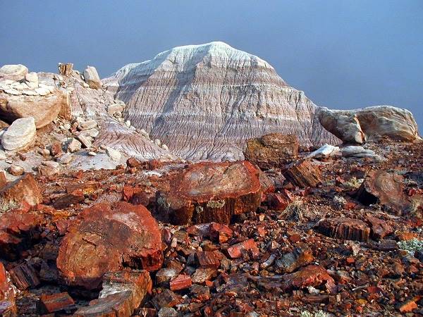
View of some petrified trees at Petrified Forest National Park

A Spanish expedition led by Francisco Vázquez de Coronado explored the area in 1539, and one group commanded by García López de Cárdenas discovered the Colorado River and became the first Europeans to see the Grand Canyon. Their route passed very close to modern Holbrock.
Spain incorporated what is now Arizona into its American Empire in 1597, and in 1821, an independent Mexico inherited the land, only to lose it in 1848 to the U.S.A., after a war. During this period of 350 years, the Navajo had raided the settlements and villages in New Mexico.
The American Army began a campaign to pacify the region by setting up a fort (Fort Defiance) in what is now Arizona in 1851. Despite the American Civil War, a harsh campaign under Gen. Carleton led to the surrender of the Navajo and their internment under terrible conditions in New Mexico. Public outrcy reversed this situation and the Navajo Treaty of 1868 allowed them to return to their homeland.
The Navajo Reservation was created and peace was attained.
Reservation Trivia
Navajo County is the third county in the US ranked by land surface designated as Indian reservations.
The Name: Holbrook
After H.R. Holbrook who was First Chief Engineer of the Atlantic and Pacific railroad.
The surname combines two Old English words: "hol" (Hollow) and "broc" (stream). It may have also absorbed the Dutch surname van Hoobroek.
Beale's Expedition
Vintage Travel Decal of the Petrified Forest, Holbrook, AZ. Route 66

The Lt. Edward Fitzgerald "Ned" Beale (1822 - 1893) was commissioned to survey and build a wagon road from Ft. Smith to California, and he followed a route that roughly lined up with what is now Route 66.
He passed through the place where Holbrook is now located, in 1857. Beale employed camels, imported from Africa as pack animals. Though hardier than mules, the camels scared both horses and mules. The Army decided not to use camels in the future.
In the meantime (1863) the Arizona Territory was separated from New Mexico and what is now Holbrook became part of Yavapai County, as it was so large, it was split up, and Apache county was created in 1879. In 1895, its western part was separated to create Navajo County. And Holbrook won the county seat beating Winslow by a narrow margin.
In 1867, the Santa Fe Stage Company (Star Mail Stage) established passenger and mail service between Santa Fe and Los Angeles; they forded the Little Colorado River at the confluence of the Rio Puerco River. Juan Padilla set up a stage station and store there. The place was called Horsehead Crossing. In 1870 a small military outpost was established there.
In 1876 the Mormons from Utah moved south along the Honeymoon Trail which also went through Horsehead Crossing.
In 1881, the Atlantic and Pacific Railroad, which later became part of the Atchison Topeka & Santa Fe Railroad set up a station 2 miles west of Horsehead Crossing and named it Holbrook. The post office opened in 1882.
The Aztec Land and Cattle Company
A vast ranch for raising cattle, it was formed in 1883 and its land spanned one million acres. It became the second largest cattle ranch in the U.S.; their ruthless cowboys kept homesteaders out and attacked the sheep ranchers. They held sway over 2 million acres. They were known after their brand, "Hashknife".
But a long dry spell and the tough winter of 1898 wiped out their cattle. They went broke in 1900.
The Hanging incident
During the 1880s and 90s, cowboys and railroad workers kept the saloons working and the heavy drinking gun-toting men gave the town a violent reputation: Holbrook was a real Wild West town. The county soon erected a Courthouse with a jail in its basement (Historic Navajo County Courthouse).
Frank Wattron, elected Sheriff in 1896, was required by Arizona State law to "invite" other sheriffs to the first (and only) execution to take place in Holbrook: a convicted murderer named George Smiley was to be hanged on Dec. 8, 1899. Jokingly, Wattron had invitations printed and sent them as required. However a reporter got his hands on one of them and it soon hit the papers all around the world, a sheriff inviting people to an execution. President McKinley got in touch with the Governor of Arizona who postponed the execution for one month and admonished the Sheriff. Smiley was hanged on Jan. 8, 1900. His ghost is said to haunt the courthouse.
Petrified wood at the Petrified Forest National Park near Holbrook, AZ. Route 66
The Flood of 1891
A fire razed the town in 1888 and a flood struck in 1891. Overgrazing led to silting in the river and more flooding. The 1923 flood cut all communications and wahed away part of the town. Business moved to the north of the railway tracks, to higher ground, further from the river. in the 1930s, the US Army Corps of Engineers built levees along the Rio Puerco to protect the town. They are still in use today.
Tourists began arriving in 1906 by rail to visit the Petrified National Monument, created that year. The National Old Trails Road reached Holbrook in 1913, and the town incorporated in 1917 and Route 66 was aligned through it in 1926.
The Interstate highway I-40 bypassed the town in the 1960s and business declined along the Main Street which had been US 66. But you can still see, and even sleep in some, the iconic motels that line the Mother Road.

The weather in Holbrook

Location of Holbrook, Route 66
Holbrook has a dry semi-arid climate with hot summers and cold winters. The day-to-night temperature swing is considerable throughout the year due to the low relative humidity; this means that Summer nights are pleasant and cool, but winter nights are quite cold.
The average high temperature during summer (July) is around 95.4°F (35.2°C) and the average summer low is approx. 598°F (15.4°C).
The winter (January) average high is 50.6°F (10.3°C); and the average low is 20.9°F which is below freezing (-6.2°C).
The arid area does not receive much rainfall, only 9.2 inches per year (234 mm). Half of it falls during the Summer Monsoon period from July to October (4.9 in. - 125 mm). There are some 49 days with precipitation every year.
Snowfall is light with about 6.3 in. per year (16 cm), which falls between October and April.
Tornado risk
There is almost zero tornado risk in Holbrook: Navajo County has no Tornado watches. The area west of the Rocky Mountains has virtually no tornado events at all.
Tornado Risk: read more about Tornado Risk along Route66.
Getting to Holbrook
To the east is Chambers (47 miles), Houck (63 mi.), and on the New Mexico state line is Lupton (75 mi). Further east, in New Mexico is Gallup (96 mi.) and even further east, Albuquerque.
To the west are Winslow (33 miles) and Flagstaff (90 miles).
Where to Stay: Motels in Holbrook
There is lodging on Route 66 in Holbrook itself.
>> Book your Hotels in Holbrook
Find More Lodging Near Holbrook along Route 66
You are so close to Las Vegas!
Click on Deals: Opens in new window
Heading West
- 33 mi. Winslow
- 73 mi. Twin Arrows Resort
- 90 mi. Flagstaff
- 99 mi. Bellemont
- 123 mi. Williams
Heading East. In Arizona
- 47 mi. Chambers
Grand Canyon Hotels
Click on Deals: Opens in new window
East In New Mexico
- 96 mi. Gallup
- 158 mi. Grants
- 178 mi. Acoma Pueblo
- 237 mi. in Albuquerque
- 272 mi. Moriarty
Find your hotel room in Holbrook
Booking.com>> There are RV campgrounds in Holbrook
Map of Route 66 through Holbrook
See a Google Map of Holbrook.
Static Map showing Route 66 alignment through Holbrook, AZ

Key to this map is the following: Pale Blue: Historic Route 66 alignment; Red line: where the original roadbed is under the modern I-40 freeway alignment.
Visit our Missing segments map showing the parts of Route 66 that can't be driven, close to -Holbrook.
Route 66 Alignment near Holbrook
With maps and full information of the old roadway.
- Winslow to Winona (next)
- Lupton to Winslow (Holbrook's)
- Albuquerque to Lupton (previous)
Holbrook, Arizona, its Sights and Attractions
Things to Do and Places to See
- Western Holbrook (this page)
- Parks and outdoors Page 2
- Eastern Holbrook Page 2
- Downtown Holbrook Page 2

Your US66 Road Trip across Western Holbrook:
Begin your Tour of Holbrook on the Northwest corner of Navajo Blvd. and Hopi Drive. We will drive west along Hopi Dr. to visit its classic sights.

Route 66 shield & signs. A. Whittall
Dinosaur statue and Route 66 Shield
Begin your walking tour in the central part of town, at the NW corner of Navajo Blvd. and Hopi Drive. Here is a large US 66 shield painted on a slab of sandstone.
Next to it are signs pointing to different towns along Route 66 with their distances in miles. Just ahead are some petrified trunks and a dinosaur statue, followed by a classic Route 66 Café.
Mural at Joe and Aggie's Café

Austin Whittall
Joe & Aggie's Cafe
120 W Hopi Blvd., Holbrook
This American Mexican food place and its owners were mentioned in the credits of the animated movie "Cars" as follows: "A Special Thanks To Those Who Inspire Us On Route 66, "The Mother Road" ... Arizona ... Aggie Montano, Alice & Stanley Gallegos, Joe & Aggie's Cafe, "Hottest Chow On The Mother Road", Holbrook, AZ."
A classic stop owned and operated by the Gallegos.
It has a menu on its eastern wall, with a map of Route 66 and the shields of US 66 for each state. Worth stopping for a photo.
Go west. Two blocks ahead, to your left is a Motel. Facing an old gas station (to your right).
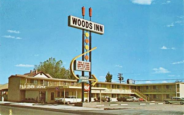
The Woods Inn now Holbrook Inn
221 W. Hopi Dr. Holbrook. The Woods Inn which nowadays is the Holbrook Inn, is depicted in the 1960s postcard shown below. On the back of the card, it promoted itself as follows: "Woods Inn 221 W. Hopi Drive Holbrook, Arizona Phone 524-3961 26 units -- Free T.V. -- Full Tile Bath -- Refrigeration -- Electric Heat -- Wall to Wall Carpeting - Telephones - Good Restaurant Close By".
A 1960s postcard of Woods Inn, Holbrook, AZ. Route 66
Holbrook, AZ Source
Nowadays it is the Holbrook Inn with a different office, but its neon sign is almost the same (with other words on it).
Holbrook Inn, today. Click for Street View

Keep west, on the following block are two motels, one on each side of the street.
The Hiway House Motel now the Roseway Inn
310 W Hopi Dr., Holbrook. To your right is the former Hiway House, later the Roseway Inn. It informed its customers in its postcard (see the image below) that: "HIWAY HOUSE® West Hopi Drive, Holbrook, Arizona Another member of the famous Flamingo-Hiway House Hotel system, noted for all the charm and deep down comfort of the 90s, but with the service and convenience of Tomorrow. Aunt Suzie's kitchen famous for food and "Grub ip a tub" box lunches".
Hiway House Motel in Holbrook, AZ. Route 66
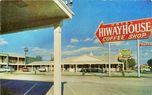
The arrow sign has changed and an air conditioning unit is on the roof, but the "Vacancy" sign seems to be the original one.


Vintage postcard Brad's Motel. Source
Brad's Desert Inn
301 W Hopi Dr. To your left, on the south side of the street is Brad's Desert Inn.
The colorful gabled roof motel has two parallel sets of rooms with a drive along the middle linking Hopi Dr. and Joy Nevin Ave.
The motel has retained its orginal layout, with its neon sign losing its arrow but still very attractive.or
It is still open as a Route 66 Motel.
> > You can Book a Room in Brad's Desert Inn
Brad's Desert Inn nowadays, Holbrook. Click image for more photos.

Then come some repurposed gas stations followed by another classic motel to your left.
Former Western Motel
521 W. Hopi Dr. Set on a corner, the former Western motel is now known as the Route 66 Self Storage, the old rooms were converted into storage areas. The neon sign is gone, but the canopy by the office is clearly the same.

Vintage postcard Western Motel. Source

Western Motel Today. Click for St. view.
On the next block to your right is one of the two Whiting Motels that were located in Holbrook.
The Whiting Motel now Economy Inn
612 W. Hopi Dr. Holbrook, AZ
The Whiting Motel is shown below in a 1970s postcard. The back of the card said "WHITING MOTELS are located in Holbrook, Winslow, Flagstaff, Williams, Kingman, and Yucca, Arizona Barstow, California and Continental Divide, San Fidel Interchange, West Albuquerque,Gallup, & Tucumcari in New Mexico, (all on Interstate 40) 612 West Hopi Drive Phone (602) 524-3946 Box 850 - Holbrook, Arizona 86025".
Whiting Motel 1970s postcard. Holbrook, AZ. Route 66
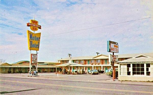
Whiting Bros. and Route 66
The Whiting Brothers were based in Arizona and had a vast network of filling stations and motels in the region, many of them along Route 66.
Four Whiting brothers (Arthur, Earnest, Eddie and Ralph) founded the company in 1926 -the same year that Route 66 was created- and saw it grow to over 100 filling stations plus fifteen motels and truck stops from California to Texas. Many of them were located along Route 66 where you can still see the remains of those that were abandoned.
Their slogan was "Most of the Best for the Least".
The company based in Arizona went through difficult times during the Arab Oil Embargo in 1973, which led to fuel shortages and when the Interstate highway system bypassed many of their service stations located on U.S. Highways (like Route 66). The company sold the stations piecemeal.
Whiting Bros. and Route 66
> > Read more: Visit our Whiting Bros. and Route 66 webpage.
Learn all about the motels and gas stations of Whiting Bros along US 66 in New Mexico and Arizona.
Below is how the WB motel looks today, an Economy Inn: basically the same building in a different color, the neon sign was gone, but they kept the same ornamental gazebo in the front court.
Economy Inn, Holbrook, on Route 66

City Center Motel
615 W Hopi Dr. Opposite the Whiting Bros., on the south side of the road are the remains of the now shuttered Magnusson Hotel, formerly the City Center Motel. The following postcards show its "Then and Now" views.

Vintage postcard City Center Motel. Source

Now in ruins (Magnusson Motel). Click for St. view
Wigwam Village Motel #6
Do it in a Teepee...
811 West Hopi Dr.Holbrook, AZ.
Listed in the National Register of Historic Places
A genuine icon on Route 66, the 1950 Wigwam Motel
Wigwam, Tepee and Hogan
A wigwam is a native shelter made from a pole structure covered with bark. It is usually used as a synonym for tipi or teepee, but they are not the same.
A teepee is a conical tent used by the natives of the Great Plains. It is made with animal hides set upon wooden poles. They have smoke flaps a the tip of the cone. The word "tipi" means "dwelling" in Lakota language (Thípi) and the word "wigwam", derives from the Algonquian "wikewam", with the same meaning.
The local Navajo natives did not use wigwams. They lived in houses called "hogan": a round or polygonal shaped building with timber or stone walls packed with earth, a door facing east and a bark roof.
The first "Wigwam Village" was built in Cave City Kentucky in 1938 by Frank Redford. He patented the idea. Chester E. Lewis liked the idea and licensed the right to use it, paying Redford a royalty fee. Lewis built a total of seven Wigwam Villages over the next 20 years. The sixth village was finished in Holbrook in 1950, hence its name "Village #6".
The motel consists of 15 freestanding teepees placed in a "U" shaped distribution around the central office. Each wigwam is made of concrete and is 21 ft. diameter (6.4 m) and 28 ft. tall (8.5 m), equipped with toilet, sink and shower and a vintage car parked in front of it.
The interstate system hurt business and Lewis sold it in the 1970s and the new owners sold gasoline. After his death, his widow and children bought it back and reopened it as a motel in 1988. Part of the central office was turned into a museum with Mr. Lewis collection of Route 66 mementos, petrified wood and Indian artifacts.
Only two other "Wigwam Villages" survive; the #2 in Cave City, Kentucky, and #7 in San Bernardino, California, the latter is on Route 66.
It is still open today and entices guests with the slogan "Have You Slept in a Wigwam Lately?"
To your right is another motel.
Sun-n-Sand Motel
902 W Hopi Dr. The former Sun-n-Sand Motel is now the Globetrotters Lodge. The building is recognizeable, with its brick-walled pool, and the neon sign which is nearly unchanged.

Vintage postcard Sun-n-Sand Motel. Source

Globetrotter Motelr. Click for Street View.
The Plainsman Restaurant Then and Now
1001 W Hopi Dr. To your left is The Plainsman. According to the postcard pictured below it was "One of Arizona's Finest Restaurants and Cocktail Lounges. West side of Holbrook on Highway 66. Adjacent to Desert View Motel, Holbrook, Arizona". It closed, yet its neon sign survived.
The Plainsman 1960s postcard in Holbrook, AZ. Route 66
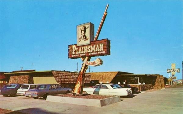
The Plainsman today in Holbrook, AZ. Route 66

Ahead, to the right is the sign of the old Sandman Motel.

Sign of the Sandman Motel. A. Whittall
Sandman Motel
1008 W. Hopi Dr. Built in 1956, it had 10 units; it was originally a Chief Motel. The sign remains and so does the building.
Opposite to it is another shuttered motel, the former Desert View Motel.
Desert View Motel
1011 W Hopi. Dr. The old motel is stil standing, it was later renamed as the Star Inn, now it is closed.

Vintage postcard Desert View Motel. Source

Star Inn now. Click for street view
This is the end of the tour of Western Holbrook
Turn around and head back to the downtown district to tour the Eastern and Southern side of town.
Tour Downtown and Eastern Holbrook
At this point you have two choices (you can do them both in the sequence you prefer) to keep on discovering and exploring Holbrok:
- Head east, leaving the downtown district into Eastern Holbrook
- Visit the sights in Dowtown Holbrook
Petrified Forest National Park
Tip: consider visiting the Petrified Forest National Park (near Holbrook) on your Road Trip.
Only National Park on Route 66

Go to Downtown and Eastern Holbrook on the Next Page
The rest of Holbrook's attractions:
Sponsored Content
>> Book your Hotel in Holbrook
Credits
Banner image: Hackberry General Store, Hackberry, Arizona by Perla Eichenblat
Jack DeVere Rittenhouse, (1946). A Guide Book to Highway 66