

Storm Data and Unusual Weather Phenomena - CIG - Mesonet
Storm Data and Unusual Weather Phenomena - CIG - Mesonet
Storm Data and Unusual Weather Phenomena - CIG - Mesonet
- No tags were found...

Create successful ePaper yourself
Turn your PDF publications into a flip-book with our unique Google optimized e-Paper software.
APRIL 2005VOLUME 47NUMBER 4STORM DATAAND UNUSUAL WEATHER PHENOMENAWITH LATE REPORTS AND CORRECTIONSnoaaNATIONAL OCEANIC AND ATMOSPHERIC ADMINISTRATIONNATIONAL ENVIRONMENTAL SATELLITE, DATA AND INFORMATION SERVICENATIONAL CLIMATIC DATA CENTER, ASHEVILLE, NC
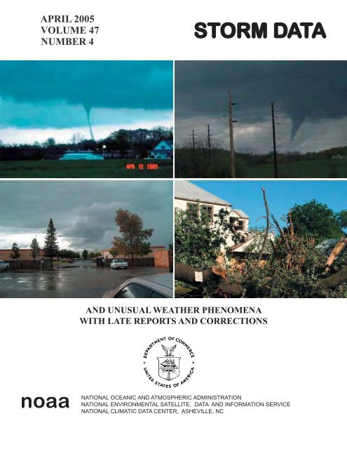
Cover(clockwise): Tornado at Rend Lake looking northeast from Sesser, IL. (Photo courtesy: Deon Seiler.) Jackson funnel cloudwas spawned by a severe thunderstorm over central Cape Girardeau County, MO. (Photo courtesy: Nick Palisch,meteorologist.)Funnel cloud north of Visalia, CA. (Photo courtesy: Adele Greene.) A large oak tree exploded <strong>and</strong> was totally destroyedfrom a lightning strike within the city limits of Hanford, CA, on April 28th, 2005. (Photo courtesy: Dan Gudgel,WCM.)TABLE OF CONTENTSPageOutst<strong>and</strong>ing <strong>Storm</strong> of the Month …..…………….….........……..…………..…….…..…..... 4<strong>Storm</strong> <strong>Data</strong> <strong>and</strong> <strong>Unusual</strong> <strong>Weather</strong> <strong>Phenomena</strong> ....…….…....………..……...........…............ 5Additiona/Corrections.......................................................................................................................... 227Reference Notes .............……...........................……….........…..……........................................... 256STORM DATA(ISSN 0039-1972)National Climatic <strong>Data</strong> CenterEditor: William AngelAssistant Editors: Stuart Hinson <strong>and</strong> Rhonda HerndonSTORM DATA is prepared, <strong>and</strong> distributed by the National Climatic <strong>Data</strong> Center (NCDC), National EnvironmentalSatellite, <strong>Data</strong> <strong>and</strong> Information Service (NESDIS), National Oceanic <strong>and</strong> Atmospheric Administration (NOAA).The <strong>Storm</strong> <strong>Data</strong> <strong>and</strong> <strong>Unusual</strong> <strong>Weather</strong> <strong>Phenomena</strong> narratives <strong>and</strong> Hurricane/Tropical <strong>Storm</strong> summaries are preparedby the National <strong>Weather</strong> Service. Monthly <strong>and</strong> annual statistics <strong>and</strong> summaries of tornado <strong>and</strong> lightning events resultingin deaths, injuries, <strong>and</strong> damage are compiled by the National Climatic <strong>Data</strong> Center <strong>and</strong> the National <strong>Weather</strong>Service’s (NWS) <strong>Storm</strong> Prediction Center.STORM DATA contains all confirmed information on storms available to our staff at the time of publication. Latereports <strong>and</strong> corrections will be printed in each edition.Except for limited editing to correct grammatical errors, the data in <strong>Storm</strong> <strong>Data</strong> are published as received.Note: “None Reported” means that no severe weather occurred <strong>and</strong> “Not Received” means that no reports were receivedfor this region at the time of printing.Subscription, pricing, <strong>and</strong> ordering information is available from:NCDC Subscription Services310 State Route 956Building 300Rocket Center, WV 26726(866) 742-3322 Toll FreeThe editor of STORM DATA solicit your help in acquiring photographs (prints or slides; black <strong>and</strong> white, or color),maps, clippings, etc. of significant or severe weather events (past or present) for use in the “Outst<strong>and</strong>ing <strong>Storm</strong>s of theMonth’’ section of STORM DATA. We request our subscribers or other interested persons to mail such items to:<strong>Storm</strong> <strong>Data</strong>National Climatic <strong>Data</strong> Center151 Patton AvenueAsheville, NC 28801e-mail: storm.data@noaa.govAny such items received by the editor will be for use in STORM DATA only. Any other use will be with the permissionof the owner of said items. Materials will be returned if requested.This is an official publication of the National Oceanic <strong>and</strong> Atmospheric Administration <strong>and</strong> is compiled from informationreceived at the National Climatic <strong>Data</strong> Center Asheville, North Carolina 28801-2733.2Thomas R. KarlDirector,National Climatic <strong>Data</strong> Center
April 2005 Confirmed Tornadoes3F Scale F0 F1 F2 F3 F4 F5 TotalNumber 76 27 2 1 0 0 106F ScaleF0F1F2F3F4F5
OUTSTANDING STORMS OF THE MONTHTHERE IS NO“OUTSTANDING STORM OF THE MONTH”FOR THE MONTH OF APRIL 2005.4
<strong>Storm</strong> <strong>Data</strong> <strong>and</strong> <strong>Unusual</strong> <strong>Weather</strong> <strong>Phenomena</strong>TimeLocal/PathLengthPathWidthNumber ofPersonsEstimatedDamageLocation Date St<strong>and</strong>ard (Miles) (Yards) Killed Injured Property Crops Character of <strong>Storm</strong>April 2005ALABAMA, CentralALZ023-031>032-037-039Tuscaloosa - Greene - Hale - Tallapoosa - Marengo01 0000CST0 0 0 0 Flood03 2300CSTApril began on an active note hydrologically across north central Alabama. Heavy rainfall occurred across much of north centralAlabama through the 2nd of April, with rainfall totals of 2 to 5 inchescommon, especially in areas to the south of a Tuscaloosa toBirmingham to Anniston line. Local amounts of 8 to 10 inches occurred over the lower portions of the Alabama River basin belowSelma. These rains produced mostly minor flooding on the lower Tallapoosa <strong>and</strong> Black Warrior Rivers, as well as on theTombigbee, Cahaba, Sucarnoochee <strong>and</strong> Alabama Rivers. Most of the flooding was minor, overflowing mostly farml<strong>and</strong>s <strong>and</strong>woodl<strong>and</strong>s along these mainstreams. However, moderate flooding occurred from around Selma downstream due to the locallyheavy inflow that occurred from the very heavy (8 to 10 inches) localized rainfall in these areas. In the Selma area, Bloch Park <strong>and</strong>the Selma Country Club experienced flooding, <strong>and</strong> some roads were closed in the area due to high water. Below Selma, flooding ofsome camps <strong>and</strong> cabins along the river occurred. Moderate flooding also occurred on the Tallapoosa River in the vicinity of theTallapoosa Water Plant, flooding portions of Lower Wetumpka Road. However, no reports of major damage from the floodinghave been received.ALZ022-024>025- Pickens - Jefferson - Shelby - Sumter - Bibb030-03401 0000CST0 0 0 0 Flood03 2300CSTApril began on an active note hydrologically across north central Alabama. Heavy rainfall occurred across much of north centralAlabama through the 2nd of April, with rainfall totals of 2 to 5 inches common, especially in areas to the south of a Tuscaloosa toBirmingham to Anniston line. Local amounts of 8 to 10 inches occurred over the lower portions of the Alabama River basin belowSelma. These rains produced mostly minor flooding on the lower Tallapoosa <strong>and</strong> Black Warrior Rivers, as well as on theTombigbee, Cahaba, Sucarnoochee <strong>and</strong> Alabama Rivers. Most of the flooding was minor, overflowing mostly farml<strong>and</strong>s <strong>and</strong>woodl<strong>and</strong>s along these mainstreams. However, moderate flooding occurred from around Selma downstream due to the locallyheavy inflow that occurred from the very heavy (8 to 10 inches) localized rainfall in these areas. In the Selma area, Bloch Park <strong>and</strong>the Selma Country Club experienced flooding, <strong>and</strong> some roads were closed in the area due to high water. Below Selma, flooding ofsome camps <strong>and</strong> cabins along the river occurred. Moderate flooding also occurred on the Tallapoosa River in the vicinity of theTallapoosa Water Plant, flooding portions of Lower Wetumpka Road. However, no reports of major damage from the floodinghave been received.ALZ033-040>042-044 Perry - Dallas - Autauga - Lowndes - Montgomery01 0000CST0 0 22K 0 Flood03 2300CSTALZ043April began on an active note hydrologically across north central Alabama. Heavy rainfall occurred across much of north centralAlabama through the 2nd of April, with rainfall totals of 2 to 5 inches common, especially in areas to the south of a Tuscaloosa toBirmingham to Anniston line. Local amounts of 8 to 10 inches occurred over the lower portions of the Alabama River basin belowSelma.These rains produced mostly minor flooding on the lower Tallapoosa <strong>and</strong> Black Warrior Rivers, as well as on theTombigbee, Cahaba, Sucarnoochee <strong>and</strong> Alabama Rivers. Most of the flooding was minor, overflowing mostly farml<strong>and</strong>s <strong>and</strong>woodl<strong>and</strong>s along these mainstreams. However, moderate flooding occurred from around Selma downstream due to the locallyheavy inflow that occurred from the very heavy (8 to 10 inches) localized rainfall in these areas. In the Selma area, Bloch Park <strong>and</strong>the Selma Country Club experienced flooding, <strong>and</strong> some roads were closed in the area due to high water. Below Selma, flooding ofsome camps <strong>and</strong> cabins along the river occurred. Moderate flooding also occurred on the Tallapoosa River in the vicinity of theTallapoosa Water Plant, flooding portions of Lower Wetumpka Road. However, no reports of major damage from the floodinghave been received.Elmore01 0000CST0 0 5K 0 Flood03 2300CSTApril began on an active note hydrologically across north central Alabama. Heavy rainfall occurred across much of north centralAlabama through the 2nd of April, with rainfall totals of 2 to 5 inches common, especially in areas to the south of a Tuscaloosa toBirmingham to Anniston line. Local amounts of 8 to 10 inches occurred over the lower portions of the Alabama River basin belowSelma. These rains produced mostly minor flooding on the lower Tallapoosa <strong>and</strong> Black Warrior Rivers, as well as on theTombigbee, Cahaba, Sucarnoochee <strong>and</strong> Alabama Rivers. Most of the flooding was minor, overflowing mostly farml<strong>and</strong>s <strong>and</strong>woodl<strong>and</strong>s along these mainstreams. However, moderate flooding occurred from around Selma downstream due to the locallyheavy inflow that occurred from the very heavy (8 to 10 inches) localized rainfall in these areas. In the Selma area, Bloch Park <strong>and</strong>the Selma Country Club experienced flooding, <strong>and</strong> some roads were closed in the area due to high water. Below Selma, flooding ofsome camps <strong>and</strong> cabins along the river occurred. Moderate flooding also occurred on the Tallapoosa River in the vicinity of theTallapoosa Water Plant, flooding portions of Lower Wetumpka Road. However, no reports of major damage from the floodinghave been received.15
<strong>Storm</strong> <strong>Data</strong> <strong>and</strong> <strong>Unusual</strong> <strong>Weather</strong> <strong>Phenomena</strong>TimeLocal/PathLengthPathWidthNumber ofPersonsEstimatedDamageLocation Date St<strong>and</strong>ard (Miles) (Yards) Killed Injured Property Crops Character of <strong>Storm</strong>April 2005ALABAMA, CentralAutauga CountyCountywide 01 0500CST0900CST0 0 8K 0 Flash FloodDoppler radar estimated a few inches of rain in a short period of time across the county. The rain fell on already saturated ground. Afew roads were temporarily impassable due to high water. A large sinkhole formed by the runoff closed Cobbs Ford Road inPrattville.Hale CountyCountywide 01 0500CST0900CST0 0 0 0 Flash FloodDoppler radar estimated several inches of rain in a short period of time across the county. Several roads were temporarilyimpassable due to high water.Dallas CountyCountywide 01 0530CST0930CST0 0 0 0 Flash FloodDoppler radar estimated several inches of rain in a short period of time across the county. The rain fell on already saturated ground.Several roads were temporarily impassable due to high water. Many local creeks<strong>and</strong> streams were out of their banks. Several residents were rescued from the flood waters.Sumter CountyCountywide 01 0530CST0930CST0 0 7K 0 Flash FloodDoppler radar estimated several inches of rain in a short period of time across the county. The rain fell on already saturated ground.Several roads were temporarily impassable due to high water. Many local creeks<strong>and</strong> streams were out of their banks.Perry CountyCountywide 01 0530CST0930CST0 0 28K 0 Flash FloodDoppler radar estimated several inches of rain in a short period of time across the county. The rain fell on already saturated ground.Several roads were temporarily impassable due to high water. Many local creeks<strong>and</strong> streams were out of their banks. A large sinkhole developed on Tutwiler Street in Marion due to the heavy rain.Jefferson CountyCountywide 01 0600CST0800CST0 0 3K 0 Flash FloodA few roads were temporarily impassable due to high water.Shelby CountyCountywide 01 0600CST0900CST0 0 2K 0 Flash FloodDoppler radar estimated several inches of rain in a short period of time across the county. Several roads were temporarilyimpassable due to high water.Lee CountyCountywide 01 0700CST1400CST0 0 300K 0 Flash FloodDoppler radar estimated several inches of rain in a short period of time across Lee County. The rain fell on already saturatedground. Several roads were flooded <strong>and</strong> were temporarily impassable. Two bridges were totally destroyed. One culvert was totallywashed away. A retaining wall collapsed in Auburn.Tallapoosa CountyCountywide 01 0700CST1400CST0 0 9K 0 Flash FloodDoppler radar estimated several inches of rain in a short period of time across the county. Several roads were temporarilyimpassable due to high water.Montgomery CountyCountywide 01 0700CST1400CST0 0 11K 0 Flash FloodDoppler radar estimated several inches of rain in a short period of time across the county. The rain fell on already saturated ground.Several roads were temporarily impassable due to high water. Many local creeks<strong>and</strong> streams were out of their banks.26
<strong>Storm</strong> <strong>Data</strong> <strong>and</strong> <strong>Unusual</strong> <strong>Weather</strong> <strong>Phenomena</strong>TimeLocal/PathLengthPathWidthNumber ofPersonsEstimatedDamageLocation Date St<strong>and</strong>ard (Miles) (Yards) Killed Injured Property Crops Character of <strong>Storm</strong>April 2005ALABAMA, CentralAutauga CountyBillingsley 01 1629CST0 0 350K 0 Thunderstorm Wind (G70)National <strong>Weather</strong> Service meteorologist surveyed the damage in Billingsley <strong>and</strong> determined the damage was caused by straight linewinds. A strong line of thunderstorms moved across central Alabama during the afternoon hours. The isolated damage was mainlyconfined to the Billingsley School property near the intersection of CR 77 <strong>and</strong> Tom Turner Road. This location was about 1 mileeast of Billingsley. A large section of the metal roofing on the school was peeled back. Ceiling insulation <strong>and</strong> small metal debrislittered areas downwind. The exposed classrooms sustained additional damage from rain. Several windows were broken out orcracked by airborne debris. One air conditioner was thrown on its side <strong>and</strong> damaged. A few trees east of the school were snappedoff. Several vehicles in the parking lot suffered dents <strong>and</strong> broken windows from flying debris.ALZ018>019-023>025 Etowah - Calhoun - Tuscaloosa - Jefferson - Shelby02 0800CST0 0 5K 0 Strong Wind1700CSTA strong cold front pushed across central Alabama early on April 2. The pressure gradient behind the front produced gusty windsacross all of central Alabama mainly during the peak heating of the day. The highest measured wind gusts were 40 to 45 miles anhour. A few trees were blown down but overall damage was very light. The wind gusts most likely occurred in every county incentral Alabama but only the counties that measured gusts appear listed above. Here are some peak measured wind gusts in miles anhour:ALZ037-044-047-049Tuscaloosa 35Birmingham 40Calera 36Gadsden 38Anniston 40Alex<strong>and</strong>er City 35Montgomery 38Troy 38Auburn 44Maxwell AFB 38Tallapoosa - Montgomery - Lee - Pike02 0800CST2200CST0 0 4K 0 Strong WindA strong cold front pushed across central Alabama early on April 2. The pressure gradient behind the front produced gusty windsacross all of central Alabama mainly during the peak heating of the day. The highest measured wind gusts were 40 to 45 miles anhour. A few trees were blown down but overall damage was very light. The wind gusts most likely occurred in every county incentral Alabama but only the counties that measured gusts appear listed above. Here are some peak measured wind gusts in miles anhour;Tuscaloosa 35Birmingham 40Calera 36Gadsden 38Anniston 40Alex<strong>and</strong>er City 35Montgomery 38Troy 38Auburn 44Maxwell AFB 38ALZ023-030>032-039 Tuscaloosa - Sumter - Greene - Hale - Marengo06090000CST2300CST0 0 0 0 FloodAdditional rainfall on the 6th <strong>and</strong> 7th produced some secondary rises, especially on the Sucarnoochee <strong>and</strong> lower Black WarriorRivers. Minor flooding occurred once again.Sumter County5 SE Livingston 06 1214CST0 0 1K 0 Hail (0.75)Penny size hail was observed just southeast of Livingston east of SR 28.Greene County4 ESE Eutaw 06 1312CST0 0 1K 0 Hail (0.75)Greene County4 ESE Eutaw 06 1312CST0 0 3KThunderstorm Wind (G40)Penny size hail fell from near Eutaw to the Black Warrior River. Several trees were also blown down in the same area.37
<strong>Storm</strong> <strong>Data</strong> <strong>and</strong> <strong>Unusual</strong> <strong>Weather</strong> <strong>Phenomena</strong>TimeLocal/PathLengthPathWidthNumber ofPersonsEstimatedDamageLocation Date St<strong>and</strong>ard (Miles) (Yards) Killed Injured Property Crops Character of <strong>Storm</strong>April 2005ALABAMA, CentralHale County5 SW Akron to 06 1312CST0 0 16K 0 Hail (1.75)6 E MoundvilleHale County5 SW Akron 061352CST1316CST0 0 0 0 Funnel CloudPenny to golf ball size hail was reported from along the Black Warrior River southwest of Moundville all the way to the TalladegaNational Forest in northeast Hale County. A funnel cloud was also spotted with thisstorm southwest of Moundville. A few vehicles were damaged by the hail.Tuscaloosa County7 SW Duncanville to 06 1352CST0 0 1K 0 Hail (1.00)7 NE Duncanville1410CSTPenny to quarter size hail was reported across southern Tuscaloosa County in <strong>and</strong> around Duncanville.Pickens County1.3 W Aliceville to 06 1651CST 1.5 50 0 0 50K 0 Tornado (F0)1.1 N Aliceville1653CSTNational <strong>Weather</strong> Service Meteorologists surveyed the damage in Aliceville <strong>and</strong> determined that the damage was caused by atornado. The tornado was rated an F0 on the Fujita Scale with localized winds of up to 73 miles an hour. The tornado touched downnear the Aliceville Manor nursing home at approximately 551 pm CDT. The weak tornado tracked northeast generally parallel to17th Street NW. At least 9 homes suffered mainly minor roof damge, although one house had major rood damage. A few porcheswere completely torn off homes <strong>and</strong> the debris was tossed up to one half of a mile away. Several outbuildings were damaged <strong>and</strong>many lawn or outdoor items were overturned. The tornado crossed SR 14 where a few large trees were snapped off or uprooted atthe Aliceville Country Club. Several additional trees <strong>and</strong> power lines were blown down along the relatively short path. The tornadolifted at the end of Country Club Lane at the Aliceville Country Club at approximately 553 pm CDT. The tornado pathlength was one <strong>and</strong> one half miles long <strong>and</strong> 50 yards wide at its widest point. No injuries were reported.Begin: 33 07.83/88 10.47 End: 33 08.70/88 09.31Lamar CountyCountywide 06 1730CST0 0 8K 0 Flash Flood1900CSTDoppler radar estimated 3 to 4 inches of rain in a short period of time. Several roads were flooded <strong>and</strong> were temporarily impassable.Several area creeks <strong>and</strong> streams rose out of their banks.ALZ040Dallas06 1740CST0 0 11K 0 Strong Wind1815CSTSeveral trees <strong>and</strong> power lines were blown down around Selma. This damaging wind occurred behind the line of thunderstorms nearthe time the rain was ending. This event was believed to be caused by a gravity wave.ALZ035Chilton06 1817CST0 0 8K 0 Strong Wind1837CSTSeveral trees <strong>and</strong> power lines were blown down near Maplesville. This damaging wind occurred behind the line of thunderstormsnear the time the rain was ending. This event was believed to be caused by a gravity wave.ALZ028Clay06 2125CST0 0 22K 0 High Wind (G51)One home sustained roof <strong>and</strong> porch damage near Delta. This damaging wind occurred behind the line of thunderstorms near thetime the rain was ending. This event was believed to be caused by a gravity wave.Pickens CountyGordo 06 2138CST0 0 1K 0 Hail (0.75)Penny size hail was reported in Gordo.Winston CountyArley 06 2230CST0 0 1K 0 Thunderstorm Wind (G55)A few trees were blown down in <strong>and</strong> around Arley.Walker CountyJasper 06 2249CST0 0 1K 0 Hail (0.75)2259CSTWalker CountyJasper 06 2249CST0 0 5K 0 Thunderstorm Wind (G55)2259CSTPenny size hail was observed in <strong>and</strong> around Japser. A few trees were also blown down in the area.48
<strong>Storm</strong> <strong>Data</strong> <strong>and</strong> <strong>Unusual</strong> <strong>Weather</strong> <strong>Phenomena</strong>TimeLocal/PathLengthPathWidthNumber ofPersonsEstimatedDamageLocation Date St<strong>and</strong>ard (Miles) (Yards) Killed Injured Property Crops Character of <strong>Storm</strong>April 2005ALABAMA, CentralCherokee County1 E Centre 07 1500CST0 0 1K 0 Hail (0.88)Nickel size hail was reported just east of Centre.ALZ018>019- Etowah - Calhoun - Jefferson - Shelby - Tallapoosa024>025-03711122300CST0500CST0 0 5K 0 Strong WindA strong wake low or gravity wave moved across central Alabama during the overnight hours. This feature occurred toward thevery tail end of a rain area <strong>and</strong> continued after the rain had ended in most locations. This feature moved rather slow <strong>and</strong> allowedthe gusty winds to last for a few hours. Gusty winds up to 30 miles an hour accompanied the feature across western Alabama <strong>and</strong>intensified just after midnight local time. As the feature moved along <strong>and</strong> south of Interstate 20 <strong>and</strong> east of Interstate 65, the highestwind gusts were estimated around 50 miles an hour. Several trees <strong>and</strong> power lines were blown down in each of the counties listed,but most of the counties across central Alabama experienced wind gusts at least 30 miles an hour. The most significant damageoccurred in Talladega, Coosa, <strong>and</strong> Elmore Counties. Some of the fallen trees l<strong>and</strong>ed on homes <strong>and</strong> caused additional damage. Thefallen trees <strong>and</strong> branches produced power outages in several locations.Here are some peak measured wind gusts in miles an hour <strong>and</strong> time observed:ALZ027-036-041-043>044Birmingham 40 1148 PM CSTCalera 35 1149 PM CSTGadsden 32 1235 AM CSTAnniston 35 348 AM CSTAlex<strong>and</strong>er City 46 320 AM CSTMontgomery 47 252 AM CSTTalladega - Coosa - Autauga - Elmore - Montgomery12 0130CST0 0 5K 0 Strong Wind0430CSTA strong wake low or gravity wave moved across central Alabama during the overnight hours. This feature occurred toward thevery tail end of a rain area <strong>and</strong> continued after the rain had ended in most locations. This feature moved rather slow <strong>and</strong> allowed thegusty winds to last for a few hours. Gusty winds up to 30 miles an hour accompanied the feature across western Alabama <strong>and</strong>intensified just after midnight local time. As thefeature moved along <strong>and</strong> south of Interstate 20 <strong>and</strong> east of Interstate 65, the highest wind gusts were estimated around 50 miles anhour. Several trees <strong>and</strong> power lines were blown down in each of the counties listed, but most of the counties across central Alabamaexperienced wind gusts at least 30 miles an hour. The most significant damage occurred in Talladega, Coosa, <strong>and</strong> Elmore Counties.Some of the fallen trees l<strong>and</strong>ed on homes <strong>and</strong> caused additional damage. The fallen trees <strong>and</strong> branches produced power outages inseveral locations.Here are some peak measured wind gusts in miles an hour <strong>and</strong> time observed: NWS OBSALZ045>046Birmingham 40 1148 PM CSTCalera 35 1149 PM CSTGadsden 32 1235 AM CSTAnniston 35 348 AM CSTAlex<strong>and</strong>er City 46 320 AM CSTMontgomeryMacon - Bullock47 252 AM CST12 0400CST0630CST0 0 2K 0 Strong WindA strong wake low or gravity wave moved across central Alabama during the overnight hours. This feature occurred toward thevery tail end of a rain area <strong>and</strong> continued after the rain had ended in most locations. This feature moved rather slow <strong>and</strong> allowedthe gusty winds to last for a few hours. Gusty winds up to 30 miles an hour accompanied the feature across western Alabama <strong>and</strong>intensified just after midnight local time. As thefeature moved along <strong>and</strong> south of Interstate 20 <strong>and</strong> east of Interstate 65, the highest wind gusts were estimated around 50 miles anhour. Several trees <strong>and</strong> power lines were blown down in each of the counties listed, but most of the counties across central Alabamaexperienced wind gusts at least 30 miles an hour. The most significant damage occurred in Talladega, Coosa, <strong>and</strong> Elmore Counties.Some of the fallen trees l<strong>and</strong>ed on homes <strong>and</strong> caused additional damage. The fallen trees <strong>and</strong> branches produced power outages inseveral locations.Here are some peak measured wind gusts in miles an hour <strong>and</strong> time observed: NWS OBSBirmingham 40 1148 PM CST59
<strong>Storm</strong> <strong>Data</strong> <strong>and</strong> <strong>Unusual</strong> <strong>Weather</strong> <strong>Phenomena</strong>TimeLocal/PathLengthPathWidthNumber ofPersonsEstimatedDamageLocation Date St<strong>and</strong>ard (Miles) (Yards) Killed Injured Property Crops Character of <strong>Storm</strong>April 2005ALABAMA, CentralCalera 35 1149 PM CSTGadsden 32 1235 AM CSTAnniston 35 348 AM CSTAlex<strong>and</strong>er City 46 320 AM CSTMontgomery 47 252 AM CSTChilton County5 S Clanton 21 1408CST0 0 6K 0 Hail (1.75)Golf ball size hail was reported by Alabama State Troopers south of Clanton.Autauga CountyPrattville 21 1432CST0 0 12K 0 Thunderstorm Wind (G51)Numerous trees were blown down in <strong>and</strong> around Prattville.Autauga CountyPrattville 21 1450CST0 0 1K 0 Hail (1.00)Quarter size was reported in <strong>and</strong> around Prattville.Montgomery County(Mgm)Montgomery Arp 21 1455CST0 0 1K 0 Hail (1.00)Quarter size was reported near the airport.Montgomery CountyHope Hull 21 1510CST0 0 17K 0 Thunderstorm Wind (G52)A roof was torn off a business on US 31 near Hope Hull.Lowndes CountyWhite Hall 21 1537CST0 0 3K 0 Thunderstorm Wind (G51)A few trees were blown down in <strong>and</strong> near White Hall.Dallas County2 E Selma 21 1543CST0 0 1K 0 Hail (0.75)Penny size hail was reported just east of Selma.Lowndes CountyBraggs 21 1610CST0 0 1K 0 Hail (1.00)Quarter size hail fell in <strong>and</strong> around the Braggs community.Perry County3 W Marion to 21 1649CST0 0 2K 0 Hail (1.75)3 S Marion1659CSTQuarter to golf ball size hail was observed in <strong>and</strong> around the city of Marion.Dallas County5 S Orrville 21 1650CST0 0 2K 0 Hail (1.75)Golf ball size hail was reported south of Orrville.Hale County10 NE Greensboro 21 1715CST0 0 1K 0 Hail (1.00)Quarter size hail was observed along SR 25 in northeastern Hale County.Dallas County8 W Minter 21 1725CST0 0 1K 0 Hail (1.00)Quarter size hail fell west of the Minter community.Hale CountyMoundville 21 1740CST1750CST0 0 6K 0 Hail (1.75)Half dollar to golf ball size hail was reported in <strong>and</strong> around Moundville.Tuscaloosa CountyFosters 21 1755CST0 0 1K 0 Hail (1.00)Quarter size hail was observed in Fosters.Tuscaloosa County5 S Tuscaloosa to 21 1759CST0 0 11K 0 Hail (1.75)11 S Tuscaloosa1832CSTQuarter to golf ball size hail fell south of the city of Tuscaloosa from near the Englewood community to near the Hale County line.The large hail completely covered the ground in several locations.Lamar County3 E Sulligent 21 1829CST0 0 1K 0 Hail (1.25)Half dollar size hail was reported in the Crews community.610
<strong>Storm</strong> <strong>Data</strong> <strong>and</strong> <strong>Unusual</strong> <strong>Weather</strong> <strong>Phenomena</strong>TimeLocal/PathLengthPathWidthNumber ofPersonsEstimatedDamageLocation Date St<strong>and</strong>ard (Miles) (Yards) Killed Injured Property Crops Character of <strong>Storm</strong>April 2005ALABAMA, CentralLamar CountySulligent 21 1840CST0 0 9K 0 Hail (1.75)Golf ball size hail was reported in Sulligent.Lamar CountyBeaverton 21 1840CST0 0 2K 0 Hail (1.75)Golf ball size hail fell in <strong>and</strong> near Beaverton.Marengo CountyDayton 21 1853CST0 0 1K 0 Hail (1.00)Quarter size hail was reported in <strong>and</strong> near the Dayton community.Lamar County6 SE Beaverton 21 1903CST0 0 1K 0 Hail (1.00)Quarter size hail was reported in <strong>and</strong> around the Mansfield community.Marengo County2 W Faunsdale 21 1938CST0 0 1K 0 Hail (0.75)Penny size hail was observed near Faunsdale.Marengo County5 SE Linden 21 2108CST0 0 1K 0 Hail (0.88)Nickel size hail was reported near SR 28 between Linden <strong>and</strong> Thomaston.Marion CountyWinfield 22 0800CST0810CST0 0 1K 0 Hail (0.75)Penny size hail briefly fell across southern Marion County near Winfield.Walker County3 NW Townley 22 0845CST0 0 1K 0 Hail (0.75)Penny size hail was reported between Jasper <strong>and</strong> Carbon Hill along US 78. A few other locations in northern Walker County alsoexperienced dime to penny size hail.R<strong>and</strong>olph CountyWedowee 22 1002CST1012CST0 0 125K 0 Thunderstorm Wind (G52)Damaging straight line winds affected areas in <strong>and</strong> around Wedowee. Several homes sustained roof damage, several docks weredamaged, one bank sustained major roof damage, <strong>and</strong> several trees <strong>and</strong> power lines were blown down. Power outages lastedthrough a large part of the afternoon.Calhoun CountyOhatchee 22 1010CST0 0 1K 0 Hail (1.00)Quarter size hail briefly fell in <strong>and</strong> near Ohatchee.Talladega CountyLincoln 22 1025CST0 0 1K 0 Hail (1.00)Talladega CountyLincoln 22 1039CST0 0 6K 0 Thunderstorm Wind (G52)Quarter size hail was reported by a trained spotter near Lincoln. The thunderstorm blew down several trees in the same area.R<strong>and</strong>olph CountyWedowee 22 1120CST1141CST0 0 3K 0 Thunderstorm Wind (G52)A few trees were blown down across the southern half of the county.Tuscaloosa CountyDuncanville 22 1145CST0 0 1K 0 Hail (0.88)Nickel size hail was reported in Duncanville.Jefferson CountyBessemer 22 1204CST0 0 1K 0 Hail (0.88)Nickel size hail was observed at Visionl<strong>and</strong> Theme Park.Jefferson CountyHoover 22 1212CST0 0 1K 0 Hail (0.75)Dime to penny size hail was reported in Bluff Park.Greene County2 NW Forkl<strong>and</strong> to 22 1212CST0 0 1K 0 Hail (0.75)4 SE Forkl<strong>and</strong>1233CSTPenny size hail fell along CR 20 between Boligee <strong>and</strong> Forkl<strong>and</strong>. The hail continued to fall south <strong>and</strong> east of Forkl<strong>and</strong> all the way tothe Black Warrior River.711
<strong>Storm</strong> <strong>Data</strong> <strong>and</strong> <strong>Unusual</strong> <strong>Weather</strong> <strong>Phenomena</strong>TimeLocal/PathLengthPathWidthNumber ofPersonsEstimatedDamageLocation Date St<strong>and</strong>ard (Miles) (Yards) Killed Injured Property Crops Character of <strong>Storm</strong>April 2005ALABAMA, CentralBibb CountyBrent to 22 1225CST0 0 1K 0 Hail (0.75)Centerville1245CSTDime to penny size hail was reported in <strong>and</strong> around Brent <strong>and</strong> Centreville.Shelby CountyAlabaster 22 1226CST0 0 1K 0 Hail (0.88)Nickel size hail fell in Alabaster.Hale County15 W Newbern to 22 1233CST0 0 4K 0 Hail (1.75)Newbern1300CSTHail up to the size of golf balls fell across southern Hale County.Hale CountyCedarville 22 1235CST0 0 2K 0 Hail (1.75)Golf ball size hail was observed in Cedarville.Perry County12 SW Marion 22 1300CST0 0 1K 0 Hail (1.00)Quarter size hail briefly fell near the Coleman community.Talladega CountyChildersburg 22 1302CST0 0 1K 0 Hail (1.00)Quarter size hail fell in Childersburg.Chilton County2 SW Thorsby to 22 1309CST0 0 1K 0 Hail (1.00)2 N Verbena1340CSTPenny to quarter size hail fell across south central Chilton County.Chilton County5 NE Maplesville to 22 1319CST0 0 1K 0 Hail (1.00)5 SE Verbena1357CSTPenny to quarter size hail was observed across southern Chilton County. This hail producing storm was a separate storm from theone that dumped hail immediately to the north. The storms merged near Verbena.Talladega County2 SE Sylacauga 22 1319CST0 0 1K 0 Hail (1.00)Quarter size hail was reported near Sylacauga.Coosa CountyGoodwater 22 1330CST1340CST0 0 1K 0 Hail (0.75)Penny size hail fell in <strong>and</strong> around Goodwater.Dallas County3 NW Selma to 22 1350CST0 0 8K 0 Hail (1.75)12 SE Selma1427CSTQuarter to golf ball size hail was reported from near Selma eastward to near the Alabama River.Autauga CountyMarbury 22 1350CST1400CST0 0 20K 0 Hail (4.50)Hail up to the size of softballs fell across extreme northeast Autauga County near Marbury.Elmore County9 NW Wetumpka 22 1405CST0 0 1K 0 Hail (1.00)Quarter size hail was reported in the Holtville area.Perry CountyUniontown 22 1406CST0 0 1K 0 Hail (0.75)Penny size hail fell in <strong>and</strong> around Uniontown.Tallapoosa CountyNewsite 22 1411CST0 0 1K 0 Hail (1.00)Quarter size hail was reported in New Site.Coosa CountyEquality 22 1421CST0 0 1K 0 Hail (0.75)Penny size hail was reported near Equality.Elmore County4 N Wetumpka 22 1424CST0 0 1K 0 Hail (1.00)Quarter size hail was observed just north of Wetumpka.812
<strong>Storm</strong> <strong>Data</strong> <strong>and</strong> <strong>Unusual</strong> <strong>Weather</strong> <strong>Phenomena</strong>TimeLocal/PathLengthPathWidthNumber ofPersonsEstimatedDamageLocation Date St<strong>and</strong>ard (Miles) (Yards) Killed Injured Property Crops Character of <strong>Storm</strong>April 2005ALABAMA, CentralLowndes County2 N White Hall to 22 1432CST0 0 5K 0 Hail (1.75)9 E Lowndesboro1513CSTHail up to the size of golf balls fell across extreme northern Lowndes County.Elmore CountyEclectic 22 1435CST0 0 11K 0 Hail (1.75)Golf ball size hail fell in <strong>and</strong> around Eclectic. The hail covered the ground.Chambers CountyLanett 22 1439CST0 0 1K 0 Hail (1.00)Quarter size hail was reported in <strong>and</strong> around Lanett.Tallapoosa County12 SW Dadeville 22 1443CST0 0 2K 0 Thunderstorm Wind (G52)A few trees were blown down just east of Lake Martin.Dallas County3 W Selma to 22 1445CST0 0 9K 0 Hail (1.75)13 SE Selma1530CSTHail up to the size of golf balls fell across central Dallas County. This was the second large hail producing storm to affect areas nearSelma within an hour or so.Lee CountyLoachapoka to 22 1503CST0 0 1K 0 Hail (1.00)Opelika1525CSTHail up to the size of quarters fell in <strong>and</strong> near Interstate 85 across much of Lee County. The storm also knocked several trees downnear Beauregard.Lee CountyCentral Portion 22 1522CST0 0 2K 0 Thunderstorm Wind (G52)Macon CountyNotasulga 22 1514CST0 0 1K 0 Hail (1.00)Quarter size hail was reported in <strong>and</strong> near Notasulga in northern Macon County.Lowndes CountyWhite Hall to 22 1518CST0 0 5K 0 Hail (1.75)Manack1544CSTHail up to the size of golf balls fell across northern Lowndes County. The was the second large hail producing storm to move acrossthe same general area within a few hours.Montgomery CountyPintlalla to 22 1518CST0 0 7K 0 Hail (1.75)10 E Grady1610CSTHail up to the size of golf balls fell across a large part of southern Montgomery County.Jefferson CountyIrondale 22 1527CST0 0 1K 0 Hail (0.75)Penny size hail was reported in Irondale.Jefferson County5 N Birmingham Arpt 22 1528CST1538CST0 0 1K 0 Hail (0.75)Penny size hail fell across north Birmingham including the cities of Fultondale, Tarrant, <strong>and</strong> Centerpoint.Russell County10 W Ladonia to 22 1535CST0 0 1K 0 Hail (0.88)Phenix City1619CSTPenny to nickel size hail was reported along US 80 from near the Hugley community eastward to Phenix City.St. Clair CountyAshville 22 1555CST1603CST0 0 1K 0 Hail (1.00)Quarter size hail was observed in <strong>and</strong> around Ashville.St. Clair CountyBranchville 22 1557CST0 0 1K 0 Hail (0.88)Nickel size hail was reported in the Branchville area.Russell County2 N Seale 22 1609CST0 0 4K 0 Hail (1.75)Golf ball size hail was reported just north of Seale.913
<strong>Storm</strong> <strong>Data</strong> <strong>and</strong> <strong>Unusual</strong> <strong>Weather</strong> <strong>Phenomena</strong>TimeLocal/PathLengthPathWidthNumber ofPersonsEstimatedDamageLocation Date St<strong>and</strong>ard (Miles) (Yards) Killed Injured Property Crops Character of <strong>Storm</strong>April 2005ALABAMA, CentralLowndes CountyHayneville 22 1610CST0 0 1K 0 Hail (1.00)Quarter size hail was observed near Hayneville. This was the third storm of the afternoon that brought large hail to north centralLowndes County.Lowndes CountyBraggs 22 1615CST0 0 1K 0 Hail (0.75)Penny size hail was reported in Braggs.Sumter County5 NW Livingston to 22 1615CST0 0 2K 0 Hail (1.00)5 SE Livingston1640CSTQuarter size hail was reported all around the city of Livingston. The hail completely covered the ground along parts of US 11.Pike County6 NE Orion 22 1615CST0 0 1K 0 Hail (0.75)Penny size hail fell in extreme northern Pike County near the China Grove community.Talladega County2 NW Talladega to 22 1625CST0 0 9K 0 Hail (1.75)5 E Munford1647CSTLarge hail up to the size of golf balls fell across northern Talladega County. Some locations that reported large hail includeStemley, Talladega, Lincoln <strong>and</strong> Munford.Calhoun County10 NW Anniston to 22 1625CST0 0 1K 0 Hail (0.88)10 NE Anniston1650CSTNickel size hail fell across north central Calhoun County.Calhoun CountyOhatchee 22 1629CST0 0 8K 0 Hail (1.75)Golf ball size hail was observed in Ohatchee.Sumter CountyGeiger to 22 1646CST0 0 2K 0 Hail (1.00)Gainesville1705CSTQuarter size hail fell across northern Sumter County from near Geiger to near Gainesville.Lowndes CountyFt Deposit 22 1650CST0 0 4K 0 Hail (1.75)Golf ball size hail was reported in <strong>and</strong> near Fort Deposit.Tuscaloosa CountyTuscaloosa 22 1650CST1700CST0 0 1K 0 Hail (0.75)Dime to Penny size hail fell across the southern part of Tuscaloosa.Pike County1 W Orion to 22 1700CST0 0 3K 0 Hail (1.75)5 SE Linwood1723CSTHail up to the size of golf balls fell across extreme northern Pike County. Wind gusts associated with this storm were estimatedaround 60 miles an hour. The large hail completely covered the ground along US 231 <strong>and</strong> traffic was temporarily halted.Pike County1 W Orion to 22 1700CST0 0 2K 0 Thunderstorm Wind (G52)5 SE Linwood1723CSTMontgomery County10 E Grady 22 1700CST1705CST0 0 1K 0 Hail (1.00)Quarter size hail was reported along the Pike <strong>and</strong> Montgomery County line along US 231.Barbour CountyBakerhill to 22 1717CST0 0 1K 0 Hail (1.00)Eufaula1730CSTQuarter size hail was reported from near Bakerhill to near Eufaula. The hail occurred all the way to the Georgia state line.Marengo CountyJefferson to 22 1720CST0 0 2K 0 Hail (1.75)3 SE Thomaston1805CSTHail up to the size of golf balls was reported from near Jefferson to near Thomaston. The large hail covered the ground in severallocations.1014
<strong>Storm</strong> <strong>Data</strong> <strong>and</strong> <strong>Unusual</strong> <strong>Weather</strong> <strong>Phenomena</strong>TimeLocal/PathLengthPathWidthNumber ofPersonsEstimatedDamageLocation Date St<strong>and</strong>ard (Miles) (Yards) Killed Injured Property Crops Character of <strong>Storm</strong>April 2005ALABAMA, CentralGreene County2 NW Forkl<strong>and</strong> 22 1722CST0 0 1K 0 Hail (1.00)Quarter size hail was reported near Forkl<strong>and</strong>.Pike CountyAnsley to 22 1732CST0 0 1K 0 Hail (1.50)8 SE Brundidge1825CSTHail up to the size of ping pong balls fell across a large part of Pike County. This was the second large hail producing storm toaffect the county in a few hours time. The hail covered the ground in several locations.Cherokee County11 NE Blanche 22 1755CST1800CST0 0 1K 0 Hail (1.00)Quarter size hail was reported in far northern Cherokee County near the Chesterfield community.Barbour CountyLouisville to 22 1757CST0 0 1K 0 Hail (1.00)Texasville1817CSTQuarter size hail fell across southern Barbour County from near Louisville to near Texasville.Perry CountyUniontown 22 1758CST0 0 1K 0 Hail (1.00)Quarter size hail was reported in <strong>and</strong> near Uniontown.Cherokee County2.1 NW Jamestown to 22 1801CST 0.4 75 0 0 4K 0 Tornado (F0)1.8 NW JamestownNational <strong>Weather</strong> Service meteorologists surveyed the damage across far northern Cherokee County. It was determined that thedamage was the result of a tornado. The tornado has been rated an F0. The tornado touched down in Dekalb County in the LittleRiver Canyon Wildlife Management Area <strong>and</strong> crossed in Cherokee County for approximately 0.4 miles. The tornado crossed thecounty line near the confluence of Hurricane Creek <strong>and</strong> Little River <strong>and</strong> ended approximately 1.2 miles west of CR 103. Severaltrees were snapped off or uprooted along the short path in Cherokee County. The tornado occurred at 701 PM CDT.Begin: 34 25.26/85 36.04 End: 34 25.19/85 35.67Cherokee County.8 NE Jamestown to 22 1803CST 0.9 75 0 0 20K 0 Tornado (F0)1.4 NE Jamestown1804CSTThe second Cherokee County tornado touched down just west of CR 15, approximatley one mile north of Jamestown, around 703PM CDT. It stayed on the ground for only about one minute, before lifting around 704 PM CDT. The total path length was 0.9miles with a path width of 75 yards at its widest point. This tornado uprooted or snapped off numerous trees along its path. A porchof one home was completely destroyed. As this tornado crossed over CR 15, a 40 year old home had its tin roof blown off <strong>and</strong>received some structural damage, which included several windows being blown out. On this same property, three to fouroutbuildings were completely destroyed.Begin: 34 24.53/85 34.26 End: 34 24.44/85 33.35Elmore CountyWetumpka 22 1806CST0 0 1K 0 Hail (1.00)1815CSTNumerous reports of quarter size hail were received from in <strong>and</strong> around Wetumpka.Montgomery CountyMontgomery to 22 1808CST0 0 11K 0 Hail (1.75)Mathews1841CSTGolf ball size hail was observed from the Montgomery metropolitan area eastward to the county line near Mathews.Cherokee County8 NE Blanche 22 1808CST0 0 8K 0 Thunderstorm Wind (G52)Several trees were blown down along CR 921. These trees were blown down by the same storm that produced the two tornadoespreviously.Montgomery County3 NE Grady 22 1825CST0 0 5K 0 Thunderstorm Wind (G52)Several trees were blown down near Dublin.Cherokee CountyBlanche to 22 1825CST0 0 1K 0 Hail (1.75)Gaylesville1845CSTHail up to the size of golf balls fell across Cherokee County. The large hail was reported in Jamestown, Blanche, Cedar Bluff <strong>and</strong>Gaylesville.1115
<strong>Storm</strong> <strong>Data</strong> <strong>and</strong> <strong>Unusual</strong> <strong>Weather</strong> <strong>Phenomena</strong>TimeLocal/PathLengthPathWidthNumber ofPersonsEstimatedDamageLocation Date St<strong>and</strong>ard (Miles) (Yards) Killed Injured Property Crops Character of <strong>Storm</strong>April 2005ALABAMA, CentralAutauga County5 W Prattville 22 1842CST0 0 1K 0 Hail (0.75)Penny size hail was observed just west of Prattville.Bullock CountyFitzpatrick to 22 1842CST0 0 1K 0 Hail (1.75)3 S Midway1937CSTLarge hail reported in the county.Jefferson County3 SW Mulga 22 1850CST0 0 1K 0 Hail (0.88)Nickel size hail was reported near Sylvan Springs <strong>and</strong> near Rock Creek.Jefferson CountyHueytown 22 1853CST0 0 1K 0 Hail (0.88)Nickel size hail fell in <strong>and</strong> around Hueytown.Cherokee CountyGaylesville 22 1854CST0 0 0 0 Funnel CloudA funnel cloud was sighted near Gaylesville.Etowah CountyGadsden 22 1854CST0 0 1K 0 Hail (1.00)Quarter size hail was observed in Gadsden.Calhoun CountyPiedmont 22 1915CST0 0 2K 0 Hail (1.75)Golf ball size hail was reported in the city of Piedmont.Barbour County5 E Mt Andrew 22 1932CST0 0 1K 0 Hail (1.00)Quarter size hail was reported near the Barbour Coutny Public Lake.Macon CountyFt Davis 22 1932CST0 0 1K 0 Hail (0.75)Penny size hail was observed near Fort Davis in extreme southern Macon County.Calhoun CountyAlex<strong>and</strong>ria 22 1933CST0 0 1K 0 Hail (0.88)Nickel size hail was reported in <strong>and</strong> around Alex<strong>and</strong>ria.Barbour CountyClio 22 2007CST0 0 1K 0 Hail (0.88)Nickel size hail was reported near Clio.Cleburne CountyHeflin 22 2014CST0 0 1K 0 Hail (0.88)Nickel size hail was reported near Heflin.Fayette CountyHubertville 30 0128CST0151CST0 0 4K 0 Thunderstorm Wind (G52)Several trees were blown down across the northeastern part of the county.Walker County5.8 E Jasper to 30 0205CST 0.6 50 0 0 125K 0 Tornado (F1)6.4 E Jasper0206CSTNational <strong>Weather</strong> Service meteorologists surveyed the damage that affected east central Walker County. It has been determined thedamage was the result of a tornado. The tornado has been rated an F1 with winds estimated around 80 miles an hour. The tornadofirst touched down at approximately 305 AM CDT in the Union Chapel area, on the north side of US 78. This location is near theintersection of US 78 <strong>and</strong> Arron Road. The tornado lifted at approximately 306 AM CDT. The tornado damage path was 0.6 mileslong <strong>and</strong> 50 yards wide at its widest point. The most significant damage caused by the tornado occurred to the Variety Outlet <strong>and</strong>the Valley Used Parts Store. The eastern part of the building was completely destroyed. The remainder of the building sustainedextensive roof damage. Roof sections were blown off to the north up to a quarter of a mile <strong>and</strong> wrapped around a telephone pole.Roof insulation stuck to the western facing store building walls <strong>and</strong> automobiles in the general vicinity. A flea market sustainedmajor damage on US 78. A few homes also received varying degrees of roof damage.Begin: 33 49.29/87 10.54 End: 33 49.36/87 09.911216
<strong>Storm</strong> <strong>Data</strong> <strong>and</strong> <strong>Unusual</strong> <strong>Weather</strong> <strong>Phenomena</strong>TimeLocal/PathLengthPathWidthNumber ofPersonsEstimatedDamageLocation Date St<strong>and</strong>ard (Miles) (Yards) Killed Injured Property Crops Character of <strong>Storm</strong>April 2005ALABAMA, CentralLamar CountyMillport 30 0209CST0227CST0 0 13K 0 Thunderstorm Wind (G52)Several trees were blown down across the southern part of the county. One mobile home park reported minor damage from fallentrees.Walker County2 N Jasper 30 0217CST0 0 1K 0 Hail (0.75)Several trees were blown down. One mobile home park reported minor damage from fallen trees.Walker CountySipsey 30 0225CST0 1 35K 0 Thunderstorm Wind (G52)Several trees <strong>and</strong> power lines were blown down in <strong>and</strong> around Sipsey. A few homes were damaged by fallen trees. One womansuffered minor injuries when a tree fell on her home.Fayette CountyNewtonville 30 0228CST0244CST0 0 11K 0 Thunderstorm Wind (G52)Several trees were blown down across the southern part of the county.Blount CountyCountywide 30 0240CST0311CST0 0 27K 0 Thunderstorm Wind (G55)Several trees <strong>and</strong> power lines were blown down across the entire county. One tree fell on a home in the far southeastern part of thecounty <strong>and</strong> caused moderate damage. One tree fell on a carport in Oneonta.Pickens CountyGordo 30 0253CST0 0 1K 0 Hail (0.75)Penny size hail was reported near Gordo.Tuscaloosa CountyCountywide 30 0302CST0351CST0 0 60K 0 Thunderstorm Wind (G55)Several trees <strong>and</strong> power lines were blown down across the county. This was in addition to the concentrated damage path of thetornado near Northport. Many of the fallen trees temporarily blocked roadways. Several homes suffered minor damage due to thefallen trees.Tuscaloosa CountyElrod 30 0308CST0 0 1K 0 Hail (0.75)Penny size hail was reported in the Sipsey Valley area near Elrod.Etowah CountyCountywide 30 0315CST0342CST0 0 27K 0 Thunderstorm Wind (G55)Several trees were blown down across Etowah County. One mobile home roof was blown off in the Coates Bend area. At least twoother homes were damaged by fallen trees.Tuscaloosa County2.2 NW Northport to 30 0316CST0 0 8K 0 Hail (1.75)5.8 NE Northport0324CSTTuscaloosa County2.2 NW Northport to 30 0316CST 6.9 100 0 0 95K 0 Tornado (F0)5.8 NE Northport0324CSTNational <strong>Weather</strong> Service meteorologists conducted a survey across areas just north northwest of Northport. It has been determinedthe area had experienced an F0 tornado, with winds of estimated around 65 mph. The tornado touched down around 416 AM CDTabout one half mile west of the CR 86 <strong>and</strong> US 43 intersection. The tornado then moved northeast, crossing SR 69 <strong>and</strong> CR 47 beforelifting near the end of CR 87 around 424 AM CDT. The tornado damage path was 6.9 miles long <strong>and</strong> 100 yards wide at its widestpoint. Numerous trees <strong>and</strong> power lines were snapped off along the path. The most concentrated damage was near the end of the pathfrom the far southeastern tip of Lake Tuscaloosa to near the end of CR 87. In this area, several homes received minor damage <strong>and</strong>two homes received significant roof damage due to fallen trees. This storm also produced large hail. The largest hail reported wasgolf ball size <strong>and</strong> occurred across the southern parts of Lake Tuscaloosa.Begin: 33 14.95/87 36.40 End: 33 16.27/87 29.46Jefferson CountyCountywide 30 0320CST0 0 9K 00405CSTSeveral trees <strong>and</strong> power lines were knocked down across the county.Thunderstorm Wind (G52)1317
<strong>Storm</strong> <strong>Data</strong> <strong>and</strong> <strong>Unusual</strong> <strong>Weather</strong> <strong>Phenomena</strong>TimeLocal/PathLengthPathWidthNumber ofPersonsEstimatedDamageLocation Date St<strong>and</strong>ard (Miles) (Yards) Killed Injured Property Crops Character of <strong>Storm</strong>April 2005ALABAMA, CentralTuscaloosa County8 ENE Tuscaloosa 30 0330CST0 0 1K 0 Hail (0.75)Penny size hail was observed in the Peterson community.Marengo County3 NW Myrtlewood 30 0335CST0 0 4K 0 Thunderstorm Wind (G55)Several trees were either uprooted or snapped off near Myrtlewood.St. Clair CountyCountywide 30 0338CST0348CST0 0 2K 0 Thunderstorm Wind (G52)A few trees were blown down across the county.Calhoun CountyCountywide 30 0343CST0427CST0 0 7K 0 Thunderstorm Wind (G52)Several trees were blown down countywide.Bibb CountyWest Blocton 30 0351CST0405CST0 0 4K 0 Thunderstorm Wind (G52)A few trees were blown down across the northern part of the county.Talladega CountyCountywide 30 0354CST0454CST0 0 20K 0 Thunderstorm Wind (G52)Several trees <strong>and</strong> power lines were knocked down countywide.Shelby CountyCountywide 30 0356CST0431CST0 0 1K 0 Hail (0.88)Shelby CountyCountywide 30 0356CST0431CST0 0 100K 0 Thunderstorm Wind (G55)Several trees were snapped off or blown down across the county. Many of the trees l<strong>and</strong>ed on homes producing damage. Onerecreational vehicle was totally destroyed <strong>and</strong> several out-buildings weredamaged. Pea to nickel size hail also fell during the storms. This damage occurred outside the identified tornado damage path.Shelby County3.3 SW Helena to 30 0404CST 11.6 100 0 0 400K 0 Tornado (F1)7.7 NE Helena0418CSTNational <strong>Weather</strong> Service meteorologists surveyed the damage that affected the Helena, Alabaster, Pelham, <strong>and</strong> Chelsea areas earlySaturday morning. The tornado has been rated an F1 with winds estimated around 75 miles an hour. The tornado first touched downjust west of County Road 93 near the Cahaba Wildlife Management Area in Helena. The tornado moved generally eastward <strong>and</strong>crossed County Road 17, County Road 58, US 31, Interstate 65 <strong>and</strong> County Road 11 before ending near County Road 39. Thetornado damage path was approximately 11.6 miles long <strong>and</strong> 100 yards wide at its widest point. The tornado was on the groundfrom approximately 504 AM CDT to 518 AM CDT. The initial damage was minor with only a few trees uprooted or snapped offwest of County Road 17 in Helena. As the tornado crossed County Road 17, it intensified <strong>and</strong> caused its most significant damage.The most concentrated <strong>and</strong> significant damage occurred near Scurlock Road <strong>and</strong> County Road 17 then eastward along County Road58 to just past County Road 95. Several subdivisions were affected including Braelinn Village, Amberley Woods, Navajo Hills, <strong>and</strong>Port South. Numerous homes suffered shingle <strong>and</strong> minor roof damage along with a few broken windows. Many trees <strong>and</strong> powerlines were either blown down or snapped off. Power was unavailable for several hours due to downed power poles. A few homessuffered major damage due to fallen trees. Several automobiles <strong>and</strong> outbuildings were destroyed. A municipal park in Helenasustained minor damage. As the tornado crossed US 31 near Walmart, several large trees <strong>and</strong> signs were blown down or snappedoff. A few homes just east of US 31 were damaged from fallen trees. For the remainder of the tornadoes path, the damage wasrelatively minor <strong>and</strong> mainly affected trees. The tornado crossed the <strong>Weather</strong>ly subdivision <strong>and</strong> the Ballantrae Golf Course <strong>and</strong>subdivision before ending just east of County Road 39 near Hidden Ridge.Begin: 33 16.08/86 53.41 End: 33 16.45/86 41.34Cherokee CountyForney 30 0405CST0 0 2K 00414CSTA few trees were blown down across the southern part of the county.Chilton CountyCountywide 30 0414CST0 0 3K 00445CSTA few trees were knocked down countywide.Thunderstorm Wind (G52)Thunderstorm Wind (G52)1418
<strong>Storm</strong> <strong>Data</strong> <strong>and</strong> <strong>Unusual</strong> <strong>Weather</strong> <strong>Phenomena</strong>TimeLocal/PathLengthPathWidthNumber ofPersonsEstimatedDamageLocation Date St<strong>and</strong>ard (Miles) (Yards) Killed Injured Property Crops Character of <strong>Storm</strong>April 2005ALABAMA, CentralShelby County2.8 NE Columbiana to 30 0422CST 2.2 150 0 0 200K 0 Tornado (F1)4.2 NE Columbiana0423CSTNational <strong>Weather</strong> Service meteorologists surveyed the damage just northeast of Columbiana. It has been determined that thedamage was the result of a tornado. The tornado has been rated an F1 on the Fujita Damage Scale with winds estimated around 75miles an hour. The tornado touched down approximately 3 miles northeast of downtown Columbiana, just west of County Road 25across the train tracks. The tornado snapped off <strong>and</strong> uprooted numerous trees <strong>and</strong> knocked over several power poles along its fairlyshort path. Some of the trees were several feet in diameter. Fallen trees significantly damaged one home, produced minor damage toa few other homes, destroyed at least 4 vehicles, <strong>and</strong> destroyed several outbuildings. The tornado crossed County Road 25 <strong>and</strong>headed eastward across mainly rural farml<strong>and</strong>. The tornado ended near the intersection of Davis Road <strong>and</strong> County Road 5 where agarage sustained roof damage <strong>and</strong> one large tree was uprooted. The tornado damage path was approximately 2.2 miles long <strong>and</strong> 150yards wide at its widest point. The tornado started at 522 AM CDT <strong>and</strong> ended at 523 AM CDT.Begin: 33 12.98/86 35.39 End: 33 13.13/86 33.20Marengo County5 E Linden 30 0426CST0 0 4K 0 Thunderstorm Wind (G52)Several trees were either snapped off or blown down along CR 39 just north of the Half Chance community.Cleburne CountyCountywide 30 0431CST0 0 2K 0 Thunderstorm Wind (G52)0512CSTA few trees were blown down throughout the county.Clay CountyCountywide 30 0458CST0 0 3K 0 Thunderstorm Wind (G52)0525CSTA few trees were blown down countywide outside of the tornado damage area.R<strong>and</strong>olph CountyCountywide 30 0509CST0 0 3K 0 Thunderstorm Wind (G52)0558CSTSeveral trees were blown down outside of the tornado damage path.Clay County11.7 S Ashl<strong>and</strong> to 30 0514CST 10.6 200 0 0 80K 0 Tornado (F1)15.2 SE Lineville0526CSTTallapoosa County5.7 NW Newsite to 30 0514CST 14.1 200 0 0 20K 0 Tornado (F1)4.3 NE Daviston0529CSTR<strong>and</strong>olph County5.1 SW Wadley to 30 0526CST 2.7 200 0 0 18K 0 Tornado (F1)2.5 SW Wadley0529CSTChambers County7 NW Milltown to 30 0529CST 1 200 0 0 3K 0 Tornado (F1)6.4 NW Milltown0530CSTR<strong>and</strong>olph County1.1 S Wadley to 30 0530CST 2.2 200 0 0 60K 0 Tornado (F1)1.2 NE Wadley0533CSTNational <strong>Weather</strong> Service meteorologists surveyed the tornado damage that started over extreme northern Tallapoosa County, about2.2 miles northwest of Goldville. It appears the tornado began at 614 AM CDT. There was F0 damage, in the form of scattered treedamage, from Vine Road just south of the Clay County line, east to near Highway 49. The damage increased to F1 damage alongHighway 49, especially to the southeast of the highway. There were several dozen trees snapped <strong>and</strong> uprooted, with many signs ofconvergence in the pattern of fallen trees. There were a few broken windows in two houses, <strong>and</strong> one house had its carport lifted upoff most of its support columns. In the same area of concentrated damage, four chicken houses sustained significant roof damage,<strong>and</strong> the tin was blown down the tornado track for about 100 yards. The chicken houses were just north of the county line, in ClayCounty. The tornado damage path was about 200 yards wide at this point. This damage occurred around 618 AM CDT. The tornadopath continued to the east with more trees blown down along the Tallapoosa-Clay county line, including across Simpson Road <strong>and</strong>County Road 79. As it crossed County Road 79, around 627 AM CDT, the damage was along the Tallapoosa-R<strong>and</strong>olph county line.The damage path entered extreme northwest Chambers County, around 630 AM, along <strong>and</strong> north of Highway 22. At this point thetornado track ran parallel to Highway 22 all the way to Wadley, on a northeast track. Three brick buildings were significantlydamaged in downtown Wadley, about 100 yards north of the Highway 22/77 intersection, on the east side of Highway 77. Thesouthern most building, built in 1925, sustained a fire several years ago <strong>and</strong> was condemned. The fire had gutted the two-storybuilding, <strong>and</strong> only the four walls were left st<strong>and</strong>ing. There was no roof on this building <strong>and</strong> it was taller than the two adjacent <strong>and</strong>attached buildings. The tornado significantly damaged at least two of the walls, <strong>and</strong> the top of the building toppled over onto theadjacent buildings, causing more damage. Since the integrity of the building had already been compromised, it was determined the1519
<strong>Storm</strong> <strong>Data</strong> <strong>and</strong> <strong>Unusual</strong> <strong>Weather</strong> <strong>Phenomena</strong>TimeLocal/PathLengthPathWidthNumber ofPersonsEstimatedDamageLocation Date St<strong>and</strong>ard (Miles) (Yards) Killed Injured Property Crops Character of <strong>Storm</strong>April 2005ALABAMA, Centraldamage was consistent with F0/F1 wind speeds. The tornado continued northeast across the Tallapoosa River <strong>and</strong> knocked downmore trees near the intersection of County Road 33 <strong>and</strong> County Road 828, near Louina. The total damage path of the tornado was17.1 miles long <strong>and</strong> 200 yards wide at its widest point. For purposes of this write-up, the tornado occurred in two counties at thesame time because its placement was directly on the county lines.Begin: 33 06.25/85 48.71 End: 33 07.39/85 33.03Elmore CountyCountywide 30 0522CST0548CST0 0 2K 0 Thunderstorm Wind (G52)A few trees were blown down across Elmore County.Dallas CountyMinter to 30 0531CST0 0 55K 0 Thunderstorm Wind (G55)5 SE Selma0557CSTSignificant wind damage occurred generally from Minter to Selma <strong>and</strong> areas eastward to the Lowndes County line. Numerous trees<strong>and</strong> power lines were knocked down across the eastern third of the county. One mobile home was totally destroyed <strong>and</strong> at least 8additional homes suffered varying degrees of damage. Several vehicles sustained damage from fallen trees. The Sardis VolunteerFire Department was damaged.Lowndes County8 W Hayneville to 30 0548CST0 4 100K 0 Thunderstorm Wind (G60)4 NW Hayneville0553CSTNational <strong>Weather</strong> Service meteorologists surveyed the damage across Central Lowndes County. The damage was determined to bethe result of straight line thunderstorm winds. Damage was first observed along County Road 17 between Panther Creek <strong>and</strong> AshCreek Church. Damage continued eastward along County Road 13 for approximately 4 miles. Extensive tree damage was observedalong this entire area. No evidence of rotation was observed. Additionally...more concentrated damage was discovered to twomobile homes <strong>and</strong> one old pillar <strong>and</strong> beam constructed home near Cherry Street. Both of the mobile homes were completelydestroyed with debris scattered up to one hundred yards downwind. Four injuries occurred in these homes, two middle agedfemales, a 2 year old girl <strong>and</strong> a 5 year old boy. Injuries were mostly cuts <strong>and</strong> bruises, although the five year old sustained severalbroken bones. A witness reported that the 5 year old was blown a considerable distance from the mobile home. The tin roof of thetraditional home was completely removed. These residences were located atop a hill which likely enhanced the winds.Lowndes County4.2 SW White Hall to 30 0552CST 1.6 50 0 1 110K 0 Tornado (F1)3 SW White Hall0553CSTNational <strong>Weather</strong> Service meteorologists surveyed the damage across northwestern Lowndes County. It was determined that thedamage was the result of a tornado that has been rated F1 on the Fujita Scale. The tornado first touched down near Mount GillardChurch, near the Intersection of US 80 <strong>and</strong> CR 17 around 652 AM CDT. It stayed on the ground for only about a minute, beforelifting around 653 AM CDT. The total path length was 1.6 miles with a width of 50 yards at its widest point. This path was parallelto CR 17, with most of the damage on the northwest side of the road. This tornado, with winds estimated around 100 mph, uprootedor snapped dozens of trees, damaged 2 mobile homes severely...produced minor damage to 3 homes <strong>and</strong> caused severe roof damageto another home. The side of one of the mobile homes was breached by an unidentified piece of debris, resulting in a 7 foot by 3foot hole. The most substantial damage to a home consisted of approximately one third of the roof being blown off, which resultedin the partial collapse of an exterior wall. One middle aged man was injured in this home but did not seek medical treatment.Begin: 32 16.51/86 44.88 End: 32 17.17/86 43.49Lowndes CountyWhite Hall 30 0553CST0 0 26K 0 Thunderstorm Wind (G55)0605CSTSeveral trees were blown down across the eastern half of Lowndes County. This damage was not concentrated but was from thesame line of storms that produced the damage near Mosses <strong>and</strong> White Hall.Lee CountyCountywide 30 0557CST0 0 4K 0 Thunderstorm Wind (G52)0645CSTA few trees were blown down across the county.Autauga CountyCountywide 30 0601CST0 0 2K 0 Thunderstorm Wind (G52)0625CSTA few trees were blown down across southern Autauga County.Chambers CountyFive Pts 30 0607CST0 0 1K 0 Hail (1.00)Quarter size hail was reported in <strong>and</strong> near Five Points.1620
<strong>Storm</strong> <strong>Data</strong> <strong>and</strong> <strong>Unusual</strong> <strong>Weather</strong> <strong>Phenomena</strong>TimeLocal/PathLengthPathWidthNumber ofPersonsEstimatedDamageLocation Date St<strong>and</strong>ard (Miles) (Yards) Killed Injured Property Crops Character of <strong>Storm</strong>April 2005ALABAMA, CentralMontgomery CountyCountywide 30 0607CST0642CST0 0 45K 0 Thunderstorm Wind (G55)Numerous trees were blown down countywide. The most significant damage occurred across the eastern part of the county. Severalstructures suffered varying degrees of roof damage.Pike CountyCountywide 30 0633CST0706CST0 0 4K 0 Thunderstorm Wind (G52)A few trees were knocked down across the county.Bullock CountyCountywide 30 0640CST0714CST0 0 8K 0 Thunderstorm Wind (G52)Several trees were blown down across Bullock County outside of the concentrated damage areas mentioned.Macon CountyCountywide 30 0644CST0710CST0 0 3K 0 Thunderstorm Wind (G52)Several trees were blown down across Macon County outside of the concentrated damage areas mentioned.Bullock County2.8 NW Perote 30 0653CST0654CST0 0 20K 0 Thunderstorm Wind (G55)Right before the tornado touched down, a large swath of straight line wind damage occurred near the Blues Old St<strong>and</strong> Community.One hundred or more large pine trees were snapped off 15 to 25 feet above the ground. The area of considerable tree damage wasapproximately two square miles.Bullock County2.8 N Perote to 30 0654CST 12.6 125 0 0 45K 0 Tornado (F0)2 S Midway0710CSTNational <strong>Weather</strong> Service meteorologists surveyed the damage along CR 14 between Blues Old St<strong>and</strong> <strong>and</strong> areas just south ofMidway. It has been determined that the damage was caused by a tornado. The tornado has been rated an F0 with winds estimatedaround 70 miles an hour. The tornado touched down near Blues Old St<strong>and</strong> around 754 AM CDT. The tornado traveled northeast forapproximately 12.6 miles before lifting about 2 miles south of Midway around 810 AM CDT. Numerous trees were snapped off <strong>and</strong>uprooted along the tornado path. The crossed US 29, SR 239 <strong>and</strong> ended just before crossing SR 51. One commercial hunting lodgewas damaged <strong>and</strong> one mobile home sustained roof damage.Begin: 31 59.22/85 43.16 End: 32 02.89/85 30.99Barbour County2 SE Mt Andrew to 30 0712CST 10 75 0 0 40K 0 Tornado (F1)1 E Comer0719CSTThe tornado first touched down southeast of Mount Andrew near CR 51 where several trees were blown down or snapped off. Asthe tornado moved northeastward, it gained strength <strong>and</strong> produced its most significant damage around the Barbour County PublicLake. Hundreds of very large trees were snapped off or blown down. Some of the trees were at least 4 feet in diameter. One home atthe lake sustained significant damage due to fallen trees. Two out-buildings, one truck, <strong>and</strong> several boats were either damaged ordestroyed on the lake property. Two 14ft aluminum boats were picked up <strong>and</strong> sent flying over 100 yards. Several lake roads weretemporarily impassable due to the fallen trees. Numerous trees were snapped off as the tornado continued northeastward across theBarbour County State Wildlife Management Area. The tornado weakened near the end of the path <strong>and</strong> only produced light treedamage near US 82 <strong>and</strong> CR 49.Begin: 31 55.82/85 29.82 End: 32 01.96/85 22.68Russell CountyHurtsboro 30 0716CST0 0 2K 0 Thunderstorm Wind (G52)A few trees were blown down in <strong>and</strong> near Hurtsboro.Lee County6.3 S Auburn 30 0723CST0 0 2K 0 Thunderstorm Wind (G52)Several large trees were blown down just east of US 29 in southern Lee County.Russell CountyPittsview to 30 0731CST0 0 8K 0 Thunderstorm Wind (G52)Cottonton0738CSTSeveral trees were blown down or snapped off near CR 4 from Pittsview to Cottonton. Additional tree damage occurred along CR12 east of Glenville.1721
<strong>Storm</strong> <strong>Data</strong> <strong>and</strong> <strong>Unusual</strong> <strong>Weather</strong> <strong>Phenomena</strong>TimeLocal/PathLengthPathWidthNumber ofPersonsEstimatedDamageLocation Date St<strong>and</strong>ard (Miles) (Yards) Killed Injured Property Crops Character of <strong>Storm</strong>April 2005ALABAMA, NorthLauderdale CountyKillen01 1425CST1426CST0 0Thunderstorm Wind (G50)A tree was blown down by thunderstorm winds in Killen.Marshall CountyGrant01 1650CST1651CST0 0Thunderstorm Wind (G55)Thunderstorm winds resulted in roof damage to a house.Marshall County5 NE Grant 01 1655CST1656CST0 0Thunderstorm Wind (G55)Thunderstorm winds blew a front porch off a house <strong>and</strong> destroyed a chicken house.Lauderdale CountyCountywide06 1530CST1730CST0 0Flash FloodSeveral roads were closed due to flooding across the county including County Road 96 in Rogersville, County Road 130 <strong>and</strong>Military Road in Green Hill, <strong>and</strong> County Road 502 in Lexington.Lawrence CountySpeake06 1723CST1900CST0 0Flash FloodSeveral inches of water over the intersection of County Road 203 <strong>and</strong> County Road 208 resulted in a road closure.Franklin CountyRussellville06 1750CST1751CST0 0Thunderstorm Wind (G50)Thunderstorm winds blew a tree down on a power line <strong>and</strong> across a road.Marshall County3 N Grant 07 1336CST1338CST0 0Hail (0.75)Penny size hail was reported at Cathedral Caverns.Cullman CountyCullman21 1630CST1633CST0 0Hail (0.88)Nickel size hail was reported.Cullman County2 S Cullman 21 1634CST1637CST0 0Hail (0.88)Nickel size hail was reported.Colbert CountySheffield21 2022CST2023CST0 0Thunderstorm Wind (G50)A tree was blown down on a house on East 20th street.Lauderdale County2 W Florence 21 2025CST2028CST0 0Hail (0.88)Nickel size hail was reported.Lauderdale County1 N Florence 21 2031CST2034CST0 0Hail (1.75)Golf ball size hail was reported.Madison CountyToney21 2245CST2248CST0 0Hail (1.75)Golf ball size hail was reported.Limestone CountyArdmore22 1700CST1704CST0 0Hail (1.00)Quarter size hail was reported.1822
<strong>Storm</strong> <strong>Data</strong> <strong>and</strong> <strong>Unusual</strong> <strong>Weather</strong> <strong>Phenomena</strong>TimeLocal/PathLengthPathWidthNumber ofPersonsEstimatedDamageLocation Date St<strong>and</strong>ard (Miles) (Yards) Killed Injured Property Crops Character of <strong>Storm</strong>April 2005ALABAMA, NorthJackson CountySection22 1705CST1712CST0 0 20KHail (1.75)Golf ball size hail was reported.Limestone CountyArdmore22 1705CST1708CST0 0Hail (1.00)Quarter size hail was reported.Jackson County3 S Section 22 1710CST1715CST0 0 50KHail (2.75)Baseball size hail was reported.Jackson CountyLangston22 1720CST1725CST0 0Hail (0.75)Penny size hail was reported.Jackson CountySection22 1730CST1735CST0 0Hail (1.25)Half dollar size hail was reported.Dekalb CountyRainsville22 1735CST1745CST0 0 25KHail (1.75)Golf ball size hail covered the ground.Marshall CountyGuntersville22 1739CST1744CST0 0Hail (1.25)Half dollar size hail was reported.Dekalb County5 ESE Ft Payne 22 1759CST1800CST0.2 60 0 0Tornado (F0)Tornado touched down briefly in Little River Canyon Wildlife Management Area near the intersection of Hurricane Creek <strong>and</strong>Little River. Numerous large trees were uprooted <strong>and</strong> snapped in this area. The damage occurred in a thickly forested area <strong>and</strong> theexact damage length was a bit uncertain. Maximum winds were estimated at 70 mph.Dekalb CountyFt Payne22 1800CST1807CST0 0Hail (1.00)Quarter size hail was reported.Dekalb CountyFyffe22 1800CST1802CST0 0 10KThunderstorm Wind (G50)A barn along County Road 502 sustained wind damage.Jackson CountyBridgeport22 1800CST1805CST0 0Hail (1.00)Quarter size hail was reported.Dekalb CountyFt Payne22 1805CST1810CST0 0Hail (2.75)Baseball size hail was reported.Dekalb CountyFt Payne22 1807CST0 0 50KHail (1.75)Golf ball size hail accumulated to a depth of 4 inches.ALZ004-006-006 Lawrence - Madison30 0040CST0100CST0 0 5KHigh Wind (G50)Probable gravity wave resulted in high winds that knocked down several trees <strong>and</strong> caused minor roof damage to a church in Caddo.1923
<strong>Storm</strong> <strong>Data</strong> <strong>and</strong> <strong>Unusual</strong> <strong>Weather</strong> <strong>Phenomena</strong>TimeLocal/PathLengthPathWidthNumber ofPersonsEstimatedDamageLocation Date St<strong>and</strong>ard (Miles) (Yards) Killed Injured Property Crops Character of <strong>Storm</strong>April 2005ALABAMA, NorthMorgan CountyDecatur30 0117CST0119CST0 0Thunderstorm Wind (G50)Thunderstorm winds knocked down a few trees in Decatur.Cullman CountyBremen30 0230CST0232CST0 0Thunderstorm Wind (G50)Thunderstorm winds blew down a large tree across County Road 81.Cullman CountyGarden City30 0240CST0242CST0 0Thunderstorm Wind (G50)Thunderstorm winds blew down a large tree across County Road 509.Marshall CountyBoaz30 0320CST0322CST0 0Thunderstorm Wind (G50)Thunderstorm winds blew down a few trees in Boaz.Dekalb CountyCollinsville30 0340CST0342CST0 0Thunderstorm Wind (G50)Thunderstorm winds blew down a large tree in Collinsville.ALABAMA, SoutheastCoffee County1 SE New Brockton 06 1900EST2000EST0 0Hail (0.88)The Coffee County EMA reported nickel size hail.Dale CountyAriton22 1940EST0 0Hail (1.75)Golfball size hail reported by the public.Dale County5 N Ozark 22 2130EST0 0 1KThunderstorm Wind (G50)The Dale County EMA reported a few trees fell on a utility pole.Coffee CountyCountywide30 0750EST0805EST0 0 15KThunderstorm Wind (G55)Numerous downed trees <strong>and</strong> power lines blocking portions of State Highways 167 <strong>and</strong> 125. A residence was damaged on CountyRoad 151 from fallen trees. Reported by the Coffee County EMA.Dale CountyCountywide30 0810EST0820EST0 0 15KThunderstorm Wind (G55)Numerous downed trees <strong>and</strong> power lines along County Roads 95 <strong>and</strong> 209, as well as State Highways 123 <strong>and</strong> 167. Reported by theDale County EMA.ALABAMA, SouthwestBaldwin CountySouth Portion 01 0000CST1130CST0 0 100KFlash FloodHeavy rains that began on March 31 <strong>and</strong> continued into April 1 caused flooding in the southern parts of the county, generally southof I-10. Numerous roads had to be closed for several hours because of the heavy rains. It was estimated that ten to fifteen inches ofrain fell across the area in a 24 hour period. Several homes were evacuated around the Styx river because of the threat of flooding.Several vehicles were flooded when people tried to drive on flooded roadways. Several bridges in the south part of the county alsosuffered damage from the water. No injuries occurred.Mobile CountySouth Portion 01 0000CST1130CST0 0 50KFlash FloodHeavy rains that began on March 31 <strong>and</strong> continued into April 1 caused flooding in the southern parts of the county. Numerousroads had to be closed for several hours because of the heavy rains. It was estimated that seven to eleven inches of rain fell acrossthe area in a 24 hour period. Some homes along the Fowl river <strong>and</strong> along low lying areas in the south part of the county wereevacuated. No injuries occurred.2024
<strong>Storm</strong> <strong>Data</strong> <strong>and</strong> <strong>Unusual</strong> <strong>Weather</strong> <strong>Phenomena</strong>TimeLocal/PathLengthPathWidthNumber ofPersonsEstimatedDamageLocation Date St<strong>and</strong>ard (Miles) (Yards) Killed Injured Property Crops Character of <strong>Storm</strong>April 2005ALABAMA, SouthwestMobile County(Mob)Mobile Bates Fl 01300000CST2359CST0 0Heavy RainThe rainfall total for April at Mobile Regional Airport was 16.62 inches. This was the third wettest April ever recorded in Mobilesince records began in 1841. The wettest April was 17.69 inches in 1955.Mobile CountyMobile01 0200CST0203CST0 0Hail (0.88)Mobile CountyDauphin Is01 0341CST0343CST0 0Hail (0.88)Mobile County(Mob)Mobile Bates Fl 01 0349CST0350CST0 0Hail (0.88)Mobile County(Mob)Mobile Bates Fl 01 0423CST0425CST0 0Hail (1.00)Mobile CountyTanner Williams 01 0430CST0434CST0 0Hail (1.00)Baldwin CountyLoxley01 0505CST0508CST0 0 15KThunderstorm Wind (G50)High winds from a thunderstorm blew down several trees <strong>and</strong> damaged a manufactured home near Loxley.Baldwin CountyFoley06 1405CST1407CST0 0Hail (0.75)Covington CountyLibertyville06 1725CST1727CST0 0 3KHail (1.75)Golfball size hail fell from a thunderstorm near Libertyville. The hail damaged some automobiles.Baldwin CountySouth Portion 06 1730CST2200CST0 0 150KFlash FloodHeavy rains again caused numerous streets to flood in the southern parts of the county. Rainfall totals of six to eight inches in atwelve hour period caused water to pond in several locations. Many drainage systems were also still clogged from debris from Ivan<strong>and</strong> caused water to pond more quickly than would normally occur. Several bridges suffered damage from the heavy rains <strong>and</strong> hadto be closed for a few days until workers could repair them. From March 31 through April 7, it was estimated that 10 to 20 inches ofrain fell across the southern parts of the county.Mobile CountySouth Portion 06 1730CST2200CST0 0 25KFlash FloodHeavy rains again caused numerous streets to flood in the southern parts of the county. Rainfall totals of six to eight inches in atwelve hour period caused water to pond in several locations. Many drainage systems were also still clogged from debris from Ivan<strong>and</strong> caused water to pond more quickly than would normally occur. From March 31 through April 7, it was estimated that 10 to 15inches of rain fell across the southern parts of the county.Mobile County(Mob)Mobile Bates Fl to 11 2349CST0 0 150KThunderstorm Wind (G75)2 E (Mob)MobileBates Fl2353CSTA thunderstorm moved just north of the airport <strong>and</strong> damaged a roof on a building at the Coast Guard station. A couple of airconditioners located on the roof were torn off <strong>and</strong> blown on the ground. There was some damage to light weight objects near thestations swimming pool area. There was also some minor tree damage at the base. The storm blew down a couple of trees just eastof the airport. One of the trees fell on a home. Just a little north of the airport, a couple of barns had their roofs damaged. One ofthe Mobile Regional Airports' wind sheer sensors, located near the Coast Guard base, measured a gust of 75 knots.Conecuh CountyEvergreenEscambia CountyBrewton21211740CST1743CST1740CST1743CST0000Hail (0.75)Hail (0.88)2125
<strong>Storm</strong> <strong>Data</strong> <strong>and</strong> <strong>Unusual</strong> <strong>Weather</strong> <strong>Phenomena</strong>TimeLocal/PathLengthPathWidthNumber ofPersonsEstimatedDamageLocation Date St<strong>and</strong>ard (Miles) (Yards) Killed Injured Property Crops Character of <strong>Storm</strong>April 2005ALABAMA, SouthwestMonroe CountyMonroeville21Crenshaw CountyHighl<strong>and</strong> HomeCrenshaw CountyHighl<strong>and</strong> HomeCrenshaw CountyBradleytonWilcox CountyAlbertaWashington CountyMillryMonroe CountyUriahMobile CountyCitronelleCrenshaw CountyHighl<strong>and</strong> Home toLuverneCrenshaw CountyLuverneBaldwin CountyBay MinetteBaldwin CountyBay MinetteMobile CountySaral<strong>and</strong>Baldwin CountyWhitehouse ForksChoctaw CountyPenningtonChoctaw CountyGilbertown221935CST1937CST1645CST1647CST0000Hail (0.75)Hail (0.75)22 1721CST0 0 5KHail (1.75)1724CSTGolfball size hail fell from a thunderstorm near Highl<strong>and</strong> Home. The large hail damaged several vehicles.22 1736CST0 0 3KHail (1.75)1739CSTGolfball size hail fell from a thunderstorm near Bradleyton. The large hail caused minor damage to a few vehicles.221820CST1823CST00Hail (1.00)22 1845CST0 0 25KLightningLightning struck a home near Millry. The strike caused a fire <strong>and</strong> part of the home was damaged.22 1925CST0 0 10KThunderstorm Wind (G50)1927CSTHigh winds from a thunderstorm blew down several trees <strong>and</strong> power lines near Uriah. One of the fallen trees damaged a vehicle.22 1930CST0 0 4KHail (1.75)1933CSTGolfball size hail fell from a thunderstorm near Citronelle. The large hail damaged several vehicles.22 1955CST0 0 15KThunderstorm Wind (G50)1958CSTSeveral trees <strong>and</strong> power lines were blown down between Highl<strong>and</strong> Home <strong>and</strong> Luverne. The trees <strong>and</strong> power lines were blowndown by high winds from a line of thunderstorms that was moving through the area.22 2010CST0 0 10K2012CSTTrees <strong>and</strong> power lines were blown down by high winds from a thunderstorm.2222262026CST2028CST2123CST2125CST1412CST1414CST000000Thunderstorm Wind (G50)Hail (1.00)Hail (0.75)Hail (0.88)26 1438CST0 0 4KHail (1.75)1440CSTGolfball size hail fell from a thunderstorm near Whitehouse Forks. The large hail damaged a few vehicles.30 0335CST0 0 10KThunderstorm Wind (G50)0337CSTTrees <strong>and</strong> power lines were blown down by high winds from a thunderstorm near Pennington.30 0350CST0 0 10KThunderstorm Wind (G50)0354CSTHigh winds from a thunderstorm blew down trees <strong>and</strong> power lines in the south part of the county. Most of the downed trees werearound Gilbertown.2226
<strong>Storm</strong> <strong>Data</strong> <strong>and</strong> <strong>Unusual</strong> <strong>Weather</strong> <strong>Phenomena</strong>TimeLocal/PathLengthPathWidthNumber ofPersonsEstimatedDamageLocation Date St<strong>and</strong>ard (Miles) (Yards) Killed Injured Property Crops Character of <strong>Storm</strong>April 2005ALABAMA, SouthwestChoctaw CountyPennington30 0415CST0417CST0 0 15KThunderstorm Wind (G50)High winds from a thunderstorm blew down several trees <strong>and</strong> power lines near Pennington. A few of the trees fell on somebuildings causing minor damage to the structures.Washington CountyYarbo30 0435CST0438CST0 0 15KThunderstorm Wind (G50)High winds from a thunderstorm blew down several trees <strong>and</strong> power lines near Yarbo. One of the trees fell on a home.Clarke CountyCoffeevilleClarke CountyWhatleyClarke CountyThomasvilleMonroe CountyMonroevilleWilcox CountyCamdenButler CountyChapmanCrenshaw CountyBradleyton to4 E BradleytonMobile CountyCentral Portion toSouth PortionBaldwin CountyCentral Portion toSouth Portion300435CST0437CST00Hail (1.00)30 0455CST0 0 15KThunderstorm Wind (G50)0458CSTHigh winds from a thunderstorm blew down several trees <strong>and</strong> power lines near Whatley. Some of the trees fell on a house <strong>and</strong>caused minor damage to the roof.30 0456CST0 0 10KThunderstorm Wind (G50)0459CSTTrees <strong>and</strong> power lines were blown down by high winds from a thunderstorm near Thomasville.30 0510CST0 0 10KThunderstorm Wind (G50)0513CSTHigh winds from a thunderstorm blew down several trees <strong>and</strong> power lines north of Monroeville.30 0515CST0 0 8KThunderstorm Wind (G50)0517CSTTrees <strong>and</strong> power lines were blown down by high winds from a thunderstorm just southeast of Camden.30 0600CST0 0 500KThunderstorm Wind (G70)0604CSTA large microburst from a thunderstorm blew down numerous trees in <strong>and</strong> around Chapman. Several of the trees fell on homes.One home had thirty four trees blown down in their yard. Luckily none fell on their house. They had just gotten their homerepaired from the damage they received from Hurricane Ivan. Another home had a large tree break through their roof. They wereasleep <strong>and</strong> the branches fell into their bedroom. They rushed into another room <strong>and</strong> the branches fell through the roof there <strong>and</strong>they were eventually able to escape into the garage. In all about 300 trees were blown down with several homes suffering damage,mostly from fallen trees. No one was injured.30 0620CST 4 200 0 0 150KTornado (F0)0624CSTA weak tornado moved across the northeast part of Crenshaw county. The tornado touched down near Bradleyton <strong>and</strong> movedalmost due east for about four miles. Most of the damage was to timber with some minor damage to a church <strong>and</strong> a few homes.The most damage occurred when a tree fell through an almost new manufactured home <strong>and</strong> split the home in two. The tornadodissipated near the Helicon community. The lady who would have normally been sleeping in the home where the tree fell, hadgone to the hospital for an appointment. Other people were sleeping on both ends of the home <strong>and</strong> never knew the tree had split thehome in two until someone woke them up. No one was injured.30 0815CST0 0Flash Flood1030CSTHeavy rains caused street flooding across the central <strong>and</strong> southern parts of the county. Rainfall totals across the area were betweenthree <strong>and</strong> five inches. Numerous streets in the south part of the county were flooded <strong>and</strong> had to be closed for a couple of hours.This is the third time this month that this same area has been impacted by heavy rains <strong>and</strong> street flooding.30 0815CST0 0Flash Flood1000CSTHeavy rains caused several streets across the central <strong>and</strong> southern parts of the county to flood. The area hardest hit was generallysouth of I-10. Rainfall totals across the area were between three <strong>and</strong> four inches. This is the third time this month that this samearea has been impacted by heavy rains <strong>and</strong> street flooding.2327
<strong>Storm</strong> <strong>Data</strong> <strong>and</strong> <strong>Unusual</strong> <strong>Weather</strong> <strong>Phenomena</strong>TimeLocal/PathLengthPathWidthNumber ofPersonsEstimatedDamageLocation Date St<strong>and</strong>ard (Miles) (Yards) Killed Injured Property Crops Character of <strong>Storm</strong>April 2005ALABAMA, SouthwestBaldwin CountyElberta30ALASKA, NorthernAKZ214AKZ219-225>226AKZ214AKZ223-225>226AKZ222AKZ223AKZ222ALASKA, SoutheastAKZ023-027>0280925CST0928CST00Hail (0.75)Yukon Delta06 0935AST0 0Blizzard1915ASTModerate northerly winds increased as a weak weather front approached; likely creating blizzard conditions at Cape Romanzof.Upper Koyukuk Valley - Denali - Ne. Slopes Of The Ern Ak Rng17 1500AST0 0Heavy Snow19 0830ASTHeavy snow occurred in several places in the interior as an Arctic front moved southeast on the 17th through 19th. In the Bettlesarea. Snow started at 0900 AST on the 16th. Total accumulation was 9.1 inches. Snow occurred from slow cooling from an ArcticFront drifting southeast over the area <strong>and</strong> warm moist air overrunning the region. Along the Alaska Range zones, the front pushedmoist air upslope to increase the cooling <strong>and</strong> produced:Zone 225 - 10.7 inches of snow in 24 hours at Denali National Park Headquarters. Snow began early in the morning of the 17thwith a total accumulation of 15.5 inches through early morning of the 19th.Zone 226 - 18 inches of snow reported by the Alaska Highway Maintenance camp at Trims on the Richardson Highway. Snowbegan on the 17th; time unknown.Yukon Delta20 1835AST0 0Blizzard2055ASTDeltana And Tanana - Denali - Ne. Slopes Of The Ern Ak Rng21 1800AST0 0High Wind (G62)23 1703ASTA strong weather front moved north from the Gulf of Alaska producing high south winds through Alaska Range Passes, as reportedat:Zone 223: Delta Junction ASOS: gust to 62 knots (71 mph).Zone 225: Amateur Radio observer: gusts to 58 knots (67 mph).Zone 226: US Army <strong>Mesonet</strong> stations: Texas Co-op: gusts to 55 knots (63 mph); Texas Range: gusts to 52 knots (60 mph).Blizzard conditions were likely at Cape Romanzof in zone 214 as the associated low pressure center approached the area on the20th.Middle Tanana Valley23 0649AST0 0Flood24 1109ASTKokomo Creek at Mile 38 of the Steese Highway flooded due to a high level of snowmelt <strong>and</strong> overrun from culverts still pluggedwith ice. One home <strong>and</strong> garage was flooded.Deltana And Tanana26 1615AST0 0Flood28 0300ASTAlong with a high amount of snowmelt, an ice jam formed in the Tanana River downstream of Piledriver slough in the Salcha Area,causing water to flow into Piledriver Slough, which then went overbank flooding portions of the Old Richardson Highway <strong>and</strong> anumber of residences along Piledriver Slough. Access to several residences were cut off during the event, <strong>and</strong> the Old Richardsonhighway had 2 to 3 feet of water over it for a time. Damage amounts unknown.Middle Tanana Valley28 0900AST0 0Flood30 2359ASTThe lower Chatanika went overbank twice from ice jams that formed downstream of a half-dozen or more cabins. Two of thecabins were flooded. Damage amount unknown. Event continued into May.Cape Decision To Salisbury Sound Coastal Area - Dixon Entrance To Cape Decision Coastal Area - SouthernInner Channels05 0500AST0 0High Wind (G56)1230ASTHigh winds from the south-southeast developed along a front that swept into the central <strong>and</strong> southern Southeast Alaskan coast.Peak wind gusts of 64 mph (56 knots) occurred on the Central Dixon Entrance buoy, <strong>and</strong> 62 mph (54 knots) at Cape Decision. Theweather spotter in Port Alex<strong>and</strong>er measured south winds sustained at 46 mph (40 knots) with gusts to 63 mph (55 knots). Otherspotter reports estimated winds in excess of 60 mph in Craig <strong>and</strong> on Blashke Isl<strong>and</strong>. No significant damage nor injuries werereported.2428
<strong>Storm</strong> <strong>Data</strong> <strong>and</strong> <strong>Unusual</strong> <strong>Weather</strong> <strong>Phenomena</strong>TimeLocal/PathLengthPathWidthNumber ofPersonsEstimatedDamageLocation Date St<strong>and</strong>ard (Miles) (Yards) Killed Injured Property Crops Character of <strong>Storm</strong>April 2005ALASKA, SouthernAKZ145Susitna Valley18192000AST2000AST0 0Heavy SnowA low moved into the south central region of Alaska Monday April 18th. This low produced moderate to heavy snow throughoutthe Susitna Valley with the heaviest snow occurring along the Parks Highway between mile posts 159 to 196. The State of AlaskaDepartment of Transportation reported 16 inches of snow fell along the highway from 1 am to 1 pm on Tuesday, April 19th.AKZ101-181 Anchorage Muni To Bird Creek - Alaska Peninsula21221300AST1100AST0 0 100KHigh Wind (G78)A strong 967 MB low moved over the False Pass area Thursday morning. The low continued northeast to the Kuskokwim DeltaThursday night. The associated front moved into the south central region of Alaska Thursday evening. Wind in advance of thisfront <strong>and</strong> the typical strong gap wind through the mountains gusted to 90 mph along the upper hillside of Anchorage Thursdaynight. Wind gusted to 86 mph along Turnagain Arm Thursday night. Southeast wind gusted to 79 mph at Cold Bay on the AlaskaPeninsula Thursday night. Damage associated with the wind occurred around the Anchorage Downtown area. A roof was torn off abuilding with an estimate of $100,000 in damage.Kenai Peninsula1.5 S Kasilof 29 1515AST1517AST0 0 1KDust DevilA dust devil was observed on the ground for approximately 2 minutes near Tustumena Lodge at mile 111 on the Sterling Highway.The Dust devil crossed the road. It was about twice the height of the surrounding trees, blew down several trees <strong>and</strong> knocked downa 20 foot sign.AMERICAN SAMOAASZ002>003 Tutuila - Manu'A02 1200SST2200SST0 02K Strong WindA combination of strong trade <strong>and</strong> east winds across the Isl<strong>and</strong>s generated debris along highways <strong>and</strong> recreational areas. Isolatedplantations at higher elevations were damaged from strong winds. Unmeasurable higher gusts were reported from other villagesin Tutuila, but no injury was reported.ASZ002>003 Tutuila - Manu'A21 1300SST2200SST0 0 0 2K Strong WindA developing Tropical Depression about 300 miles southwest of Tutuila impacted local condition over Tutuila <strong>and</strong> Manu'a Isl<strong>and</strong>son April 21st. Increasing downslope winds affected most residents in Tutuila <strong>and</strong> Manu'a, causing downed plantation for somefarmers on Tutuila. <strong>Weather</strong> Spotters reported flying tents <strong>and</strong> outdoor furnitures from this episode. No injury reported.ARIZONA, Central <strong>and</strong> NortheastAZZ014Little Colorado River Valley In Apache County04 1300MST1900MST0 0High Wind (G59)A strong Pacific cold front moved across northern Arizona on April 4 with very strong wind. The strongest wind was in the easternLittle Colorado River Valley. St Johns airport had a wind gust to 59 MPH. The Petrified Forest National Park reported sustainedwind between 40 <strong>and</strong> 50 MPH with a peak wind gust of 68 MPH. Blowing dust reduced the visibility to near zero at the park.AZZ004Kaibab Plateau06072300MST0700MST0 0High Wind (G63)A strong Pacific cold front brought high winds to the Kaibab Plateau overnight April 6 to 7. Remote Automated <strong>Weather</strong> Stations(RAWS) recorded peak wind gusts of 73 MPH at Four Springs <strong>and</strong> 60 MPH at Paria Point.AZZ012>013-015 Little Colorado River Valley In Coconino County - Little Colorado River Valley In Navajo County - WesternMogollon Rim19 0900MST1900MST0 0High Wind (G66)A strong area of low pressure over southern Utah brought very strong winds to much of northern Arizona on April 19. Thestrongest winds were observed from East Flagstaff, into the Little Colorado River Valley, <strong>and</strong> into the Winslow area. The highestwind gusts were reported in Leupp (76 MPH), Doney Park (64 MPH), <strong>and</strong> Winslow (63 MPH). In Winslow, there were some poweroutages <strong>and</strong> a trampoline blew into a car. A semi truck <strong>and</strong> trailer was blown onto its side on I-40 near Winslow. The visibility wasbelow 1/2 mile between Holbrook <strong>and</strong> Winslow between 4:00 <strong>and</strong> 5:00 PM.Coconino CountyFlagstaff Arpt 23 1640MST0 0Funnel CloudA funnel cloud was sighted east of Lake Mary Road in southeast Flagstaff.2529
<strong>Storm</strong> <strong>Data</strong> <strong>and</strong> <strong>Unusual</strong> <strong>Weather</strong> <strong>Phenomena</strong>TimeLocal/PathLengthPathWidthNumber ofPersonsEstimatedDamageLocation Date St<strong>and</strong>ard (Miles) (Yards) Killed Injured Property Crops Character of <strong>Storm</strong>April 2005ARIZONA, Central <strong>and</strong> NortheastAZZ013Little Colorado River Valley In Navajo County24 0151MST0 0High Wind (G60)A house trailer was moved 30 to 40 feet <strong>and</strong> ended up on its side. No one in the trailer was hurt. Two power poles were also blowndown. The wind lasted less than ten minutes.ARIZONA, NorthwestARIZONA, SouthNONE REPORTED.NONE REPORTED.ARIZONA, SouthwestLa Paz County2 S Quartzsite 23 1603MST0 0Funnel Cloud1608MSTMotorist on Interstate 10 observed funnel cloud.Yuma County5 E Yuma 23 1657MST0 0 20KThunderstorm Wind (G50)Winds associated with thunderstorms damaged roofs <strong>and</strong> carports. Power was knocked out in parts of the Yuma Foothills area.Small hail was also reported with these thunderstorms.Maricopa CountyWickenburg23 1809MST0 0Hail (0.75)ARKANSAS, Central <strong>and</strong> North CentralPolk County2 S Cove 05 1935CST0 0Hail (0.75)Polk CountyHatfield05 1938CST0 0Hail (0.75)Pike CountyLangley05 2030CST0 0Hail (0.75)Montgomery CountyNorman05 2035CST0 0Thunderstorm Wind (G50)Thunderstorm winds downed some power lines.Johnson County4 NE Clarksville 05 2115CST0 0Thunderstorm Wind (G50)Several large trees were blown down.Perry CountyPerry05 2125CST0 0Thunderstorm Wind (G50)Thunderstorm winds blew down some trees.Searcy CountyLeslie05 2130CST0 0 5KThunderstorm Wind (G45)Thunderstorm winds blew the metal roofing off several buildings in Leslie.Pope CountyPottsville05 2130CST0 0Thunderstorm Wind (G50)Pope CountyRussellville05 2130CST0 0Thunderstorm Wind (G50)Pope CountyMorel<strong>and</strong>05 2140CST0 0Thunderstorm Wind (G50)Severe thunderstorms downed numerous trees <strong>and</strong> power lines across portions of Pope County.Garl<strong>and</strong> County6 SW Hot Spgs 05 2132CST0 0Hail (0.75)Conway CountyOvercup05 2155CST0 0Thunderstorm Wind (G50)Thunderstorm winds downed some power lines.Van Buren CountyClinton05 2210CST0 0Thunderstorm Wind (G50)Thunderstorm winds blew down some trees <strong>and</strong> power lines.2630
<strong>Storm</strong> <strong>Data</strong> <strong>and</strong> <strong>Unusual</strong> <strong>Weather</strong> <strong>Phenomena</strong>TimeLocal/PathLengthPathWidthNumber ofPersonsEstimatedDamageLocation Date St<strong>and</strong>ard (Miles) (Yards) Killed Injured Property Crops Character of <strong>Storm</strong>April 2005ARKANSAS, Central <strong>and</strong> North CentralStone County2 S Mountain View 05 2245CST0 0Thunderstorm Wind (G50)Wind gusts from a severe thunderstorm blew the front porch off a store just south of Mountain Home.Pulaski CountyLittle Rock11 0425CST0 0Hail (0.75)Pulaski CountyOak Grove11 0430CST0 0Hail (0.75)White CountyRomance11 0520CST0 0Hail (1.75)Saline CountyBenton11 0523CST0 0Hail (1.00)Grant CountySheridan11 0555CST0 0Hail (0.75)Monroe County5 N Clarendon 11 1030CST1300CST0 0Flash FloodHeavy rains caused some localized flash flooding to occur north of Clarendon. Highway 302 was covered by high water <strong>and</strong>impassible for several hours.Arkansas County10 E Stuttgart 11 1200CST1300CST0 0Flash FloodHeavy rains flooded parts of Highway 153 east of Stuttgart. The highway was blocked for about an hour due to the high waterlevels.Yell County3 SW Dardanelle to 11 1745CST 2.1 25 0 0Tornado (F0)1.7 WSW Dardanelle 1752CSTJohnson CountyCoal HillJohnson CountyHartmanIn the picture: <strong>Storm</strong>s were fairly isolated in western Arkansas during the afternoon of 04/11/2005. One of the storms produced aweak tornado a few miles west of Dardanelle (Yell County). The picture is courtesy of Jason Politte.A weak tornado touched down briefly to the southwest of Dardanelle. The only notable damage along the path of the tornado werea number of downed trees <strong>and</strong> others where their tops were twisted off. The tornado was witnessed <strong>and</strong> photographed by a visitorto a nearby state park.11111845CST1855CST0000Hail (1.00)Hail (1.00)2731
<strong>Storm</strong> <strong>Data</strong> <strong>and</strong> <strong>Unusual</strong> <strong>Weather</strong> <strong>Phenomena</strong>TimeLocal/PathLengthPathWidthNumber ofPersonsEstimatedDamageLocation Date St<strong>and</strong>ard (Miles) (Yards) Killed Injured Property Crops Character of <strong>Storm</strong>April 2005ARKANSAS, Central <strong>and</strong> North CentralBaxter County3 NE Buford 21 1440CST0 0Thunderstorm winds downed several trees.Johnson CountyPiney21 1507CST0 0Baxter County2 NE Briarcliff 21 1510CST0 0Baxter CountyNorfork21 1513CST0 0Thunderstorm winds downed a number of trees <strong>and</strong> power lines.Marion CountyPeel21 1520CST0 0Pope CountyLondon21 1525CST0 0Izard CountyWideman21 1605CST0 0Izard County2 S Oxford 21 1618CST0 0Izard County1 N Oxford 21 1620CST0 0Izard CountyCalico Rock21 1626CST0 0Izard CountyZion21 1737CST0 0Independence County5 N Batesville 21 1832CST0 0Independence CountyNewark21 1856CST0 0Independence CountyCord21 1858CST0 0Independence CountyNewark to21 1900CST0 0New HopeJackson CountyTuckerman21 1913CST0 0Van Buren CountyDennard28 2015CST0 0Pope CountyRussellville29 0515CST0 0Pope CountyAtkins29 0523CST0 0Thunderstorm Wind (G50)Hail (0.75)Thunderstorm Wind (G50)Thunderstorm Wind (G50)Hail (0.75)Hail (1.00)Hail (0.75)Hail (1.00)Hail (1.00)Hail (1.00)Hail (0.75)Hail (0.75)Hail (1.00)Hail (1.00)Hail (1.00)Hail (1.75)Hail (1.75)Hail (1.00)Hail (1.75)2832
<strong>Storm</strong> <strong>Data</strong> <strong>and</strong> <strong>Unusual</strong> <strong>Weather</strong> <strong>Phenomena</strong>TimeLocal/PathLengthPathWidthNumber ofPersonsEstimatedDamageLocation Date St<strong>and</strong>ard (Miles) (Yards) Killed Injured Property Crops Character of <strong>Storm</strong>April 2005ARKANSAS, Central <strong>and</strong> North CentralPope CountyPottsville29 0537CST00Hail (1.75)In the picture: Numerous hail storms developed north of a warm front in about the northern half of Arkansas on 04/29/2005. Southof the front, a layer of warm air aloft kept the atmopshere capped with no storms noted.Cleburne County8 SW Heber Spgs 29 0545CST0 0Hail (1.75)Cleburne County6 SE Heber Spgs 29 0550CST0 0Hail (1.25)Johnson County4 E Clarksville 29 0550CST0 0Hail (0.75)White CountyPangburn29 0600CST0 0Hail (1.25)Faulkner CountyGuy29 0600CST0 0Hail (0.88)Faulkner County4 SE Guy 29 0605CST0 0Hail (0.75)Faulkner County10 E Greenbrier 29 0610CST0 0Hail (0.75)Logan County10 ENE Magazine 29 0610CST0 0Hail (1.75)Several vehicles <strong>and</strong> campers were damaged by golfball sized hail at Mt. Magazine State Park.White County14 N Judsonia 29 0620CST0 0Hail (1.00)Yell County3 E Chickalah 29 0630CST0 0Hail (1.75)Yell CountyDanville29 0630CST0 0Hail (1.25)Yell CountyOla29 0638CST0 0Hail (1.75)White CountySearcy29 0645CST0 0Hail (0.88)White CountyJudsonia29 0653CST0 0Hail (0.88)2933
<strong>Storm</strong> <strong>Data</strong> <strong>and</strong> <strong>Unusual</strong> <strong>Weather</strong> <strong>Phenomena</strong>TimeLocal/PathLengthPathWidthNumber ofPersonsEstimatedDamageLocation Date St<strong>and</strong>ard (Miles) (Yards) Killed Injured Property Crops Character of <strong>Storm</strong>April 2005ARKANSAS, Central <strong>and</strong> North CentralPerry CountyBigelow29 0720CST0 0Perry County1 S Perryville 29 0725CST0 0Faulkner County1 S Mayflower 29 0740CST0 0Faulkner County1 S Mayflower 29 0743CST0 0Faulkner CountyCato29 0750CST0 0Hail covered the ground at several locations in southern Faulkner County.Pulaski County3 NW Morgan 29 0746CST0 0Pulaski CountyRunyan Acres 29 0750CST0 0Pulaski County1 N Gravel Ridge 29 0755CST0 0Pulaski County1 S Jacksonville 29 0800CST0 0Pulaski CountyLittle Rock Afb 29 0800CST0 0Pulaski CountyJacksonville29 0804CST0 0Pulaski CountyJacksonville29 0808CST0 0Lonoke CountyCabot29 0815CST0 0Faulkner County2 W Conway 29 0819CST0 0Faulkner County2 SE Conway 29 0845CST0 0Lonoke CountyCabot29 0853CST0 0Lonoke County1 W Cabot 29 0855CST0 0Lonoke CountyWard29 0857CST0 0Lonoke CountyWard29 0900CST0 0Prairie CountyHickory Plains 29 0920CST0 0White CountySearcy29 1020CST0 0White CountySearcy29 1026CST0 0White CountySearcy29 1030CST0 0Woodruff CountyMc Crory29 1055CST0 0Pope CountyRussellville29 1208CST0 0Cleburne County5 SW Heber Spgs 29 1330CST0 0Cleburne County6 SE Wilburn 29 1330CST0 0Hail (1.25)Hail (1.00)Hail (1.00)Hail (0.88)Hail (1.00)Hail (1.00)Hail (0.88)Hail (1.50)Hail (1.75)Hail (1.00)Hail (1.00)Hail (1.75)Hail (0.75)Hail (1.75)Hail (1.75)Hail (1.50)Hail (1.75)Hail (1.00)Hail (0.75)Hail (0.75)Hail (0.75)Hail (1.00)Hail (0.75)Hail (0.75)Hail (0.88)Hail (1.75)Hail (1.75)3034
<strong>Storm</strong> <strong>Data</strong> <strong>and</strong> <strong>Unusual</strong> <strong>Weather</strong> <strong>Phenomena</strong>TimeLocal/PathLengthPathWidthNumber ofPersonsEstimatedDamageLocation Date St<strong>and</strong>ard (Miles) (Yards) Killed Injured Property Crops Character of <strong>Storm</strong>April 2005ARKANSAS, Central <strong>and</strong> North CentralJackson CountyErwin29 1415CST0 0Cleburne CountyHeber Spgs29 1420CST0 0Cleburne County5 SW Heber Spgs 29 1445CST0 0Jackson County5 WSW Ingleside 29 1457CST0 0Jackson CountyOlyphant29 1500CST0 0ARKANSAS, EastCraighead CountyCaraway29 1410CST0 0 0.10K1415CSTMississippi County2 N Three Way 29 1420CST0 0 0.10K1425CSTMississippi CountyLuxora29 1437CST0 0 0.10K1445CSTPoinsett CountyWeiner29 1442CST0 0 5K1450CSTSeveral vehicles were damaged.Poinsett CountyFisher29 1527CST0 0 0.75K1535CSTPoinsett CountyMarked Tree29 1602CST0 0 0.10K1610CSTMississippi CountyDyess29 1617CST0 0 0.01K1625CSTARKANSAS, NorthwestSebastian County1 W Ft Smith 05 1907CST0 0Crawford CountyVan Buren05 1922CST0 0Washington CountyCincinnati05 1925CST0 0Crawford CountyMountainburg 05 1935CST0 0Benton CountyBentonville05 2002CST0 0Franklin County7 WNW Ozark 05 2010CST0 0Franklin County2 N Altus 11 1456CST0 0Franklin County2 N Ozark 11 1510CST 0.1 30 0 0A tornado briefly touched down near Hudspeth Lake just north of I-40.Franklin County2 S Altus 11 1543CST0 0Franklin CountyAltus11 1553CST0 0Carroll County1 NE Beaver 11 1643CST0 0Hail (1.75)Hail (0.75)Hail (0.75)Hail (1.75)Hail (1.25)Hail (1.00)Hail (1.00)Hail (1.00)Hail (1.75)Hail (1.75)Hail (1.00)Hail (0.75)Hail (0.75)Hail (0.88)Hail (0.75)Hail (1.00)Hail (0.75)Hail (0.88)Hail (1.00)Tornado (F0)Hail (1.25)Hail (0.75)Hail (1.00)3135
<strong>Storm</strong> <strong>Data</strong> <strong>and</strong> <strong>Unusual</strong> <strong>Weather</strong> <strong>Phenomena</strong>TimeLocal/PathLengthPathWidthNumber ofPersonsEstimatedDamageLocation Date St<strong>and</strong>ard (Miles) (Yards) Killed Injured Property Crops Character of <strong>Storm</strong>April 2005ARKANSAS, NorthwestCarroll CountyGreen Forest11 1645CST0 0Carroll CountyGreen Forest11 1645CST0 0Thunderstorm winds estimated at 60 miles an hour blew down large tree limbs.Carroll County3 N Coin 11 1705CST0 0Franklin County4 SE Cecil 21 1512CST0 0Franklin County6 S Ozark 21 1516CST0 0Crawford CountyFigure Five29 0550CST0 0Franklin County4 W Ozark 29 0620CST0 0Franklin CountyAltus29 0639CST0 0Franklin County4 W Ozark 29 0652CST0 0Franklin CountyOzark29 0700CST0 0ARKANSAS, SoutheastHail (0.75)Thunderstorm Wind (G52)Hail (0.75)Hail (1.75)Hail (0.88)Hail (0.75)Hail (0.88)Hail (1.00)Hail (0.88)Hail (0.75)NOT RECEIVED.ARKANSAS, SouthwestSevier CountyLockesburg05 2038CST0 0 125KLightningLightning struck a home in town resulting in a fire. The house burned to the ground but there were no injuries.Lafayette CountyStamps26 0040CST0 0Hail (1.00)Lafayette CountyStamps to26 0040CST0 0Hail (1.00)LewisvilleATLANTIC OCEANChesapeake Bay NewPt Comfort To CpHenry VaNew Point Comfort to 02 1743EST0 0Marine Tstm WindCape HenryWind gust of 39 knots measured at ORF.Chesapeake Bay NewPt Comfort To CpHenry VaNew Point Comfort to 02 1812EST0 0Marine Tstm WindCape HenryWind gust of 37 knots measured at Kiptopeke.Cp Charles Lt Va ToNc-Va Bdr Out 20NmCape Charles Light to 02 1824EST0 0Marine Tstm WindNc-Va BorderWind gust of 42 knots measured at the Chesapeake Bay Bridge Tunnel.Chesapeake BaySmith Pt To WindmillPt VaSmith Pt to02 1906EST0 0Marine Tstm WindWindmill PointWind gust of 41 knots measured at Lewisetta.3236
<strong>Storm</strong> <strong>Data</strong> <strong>and</strong> <strong>Unusual</strong> <strong>Weather</strong> <strong>Phenomena</strong>TimeLocal/PathLengthPathWidthNumber ofPersonsEstimatedDamageLocation Date St<strong>and</strong>ard (Miles) (Yards) Killed Injured Property Crops Character of <strong>Storm</strong>April 2005ATLANTIC OCEANS<strong>and</strong>y Hook ToManasquan Inlet NjOut 20NmS<strong>and</strong>y Hook Bay 28 1500EST0 00 Marine Tstm WindA gust front from showers that moved across northern New Jersey caused winds to gust to 40 knots (46 mph) in S<strong>and</strong>y Hook.New York HarborStation Bgnn4 28 1505EST0 0Marine Tstm WindFire Isl<strong>and</strong> Inlet NyTo S<strong>and</strong>y Hook NjOut 20NmLong Beach28 1538EST0 0Marine Tstm WindLong Isl<strong>and</strong> Sound WOf New Haven Ct ToPort Jefferson Ny12 W Bridgeport Airpo 28 1541EST0 0Marine Tstm WindMoriches Inlet ToFire Isl<strong>and</strong> Inlet NyOut 20Nm13 E Fire Isl<strong>and</strong> Inlet 28 1548EST0 0Marine Tstm WindMoriches Inlet ToFire Isl<strong>and</strong> Inlet NyOut 20Nm11 NE Fire Isl<strong>and</strong> Inlet 28 1603EST0 0Marine Tstm WindLong Isl<strong>and</strong> Sound EOf New Haven Ct ToPort Jefferson Ny1 NE New Haven Airpo 28 1616EST0 0Marine Tstm WindLong Isl<strong>and</strong> Sound WOf New Haven Ct ToPort Jefferson NyBridgeport Airport 28 1858EST0 0Marine Tstm WindLong Isl<strong>and</strong> Sound EOf New Haven Ct ToPort Jefferson NyPort Jefferson Harbor 28 1917EST0 0Marine Tstm WindAs a line of showers moved quickly east, it produced wind gusts from 35 knots at Westport Connecticut to 49 knots at the NOSPORTS Bergen Point wind system. Trained spotters reported that high winds over turned 2 boats in the Great South Bay.Manasquan Inlet ToLittle Egg Inlet NjOut 20NmPt. Pleasant to 28 1600EST0 00 Marine Tstm WindBarnegat InletA gust front from showers that moved across northern New Jersey caused winds to gust to 38 knots (44 mph) at Barnegat Inlet <strong>and</strong>36 knots (42 mph) at Point Pleasant.CALIFORNIA, Extreme SoutheastNONE REPORTED.CALIFORNIA, North CentralNONE REPORTED.CALIFORNIA, NortheastCAZ072Greater Lake Tahoe Area03 1900PST0 0Heavy Snow04 0300PSTA winter storm moved through eastern California <strong>and</strong> western Nevada on the 3rd <strong>and</strong> 4th. Snowfall amounts in the central Sierraapproached two feet in the higher elevations.3337
<strong>Storm</strong> <strong>Data</strong> <strong>and</strong> <strong>Unusual</strong> <strong>Weather</strong> <strong>Phenomena</strong>TimeLocal/PathLengthPathWidthNumber ofPersonsEstimatedDamageLocation Date St<strong>and</strong>ard (Miles) (Yards) Killed Injured Property Crops Character of <strong>Storm</strong>April 2005CALIFORNIA, Northeast<strong>Storm</strong> total snowfall amounts:Sierra-at-Tahoe Ski Resort (8800 ft.)Alpine Meadows Ski Resort (mid-mtn)Soda Springs Ski ResortKingvale (6100 ft.)Squaw Valley Ski Resort (8200 ft.)CAZ07321 inches16 inches16 inches11 inches10 inchesMono03042000PST0300PST0 0Heavy SnowA winter storm moved through eastern California <strong>and</strong> western Nevada on the 3rd <strong>and</strong> 4th. Snowfall amounts in the central Sierraapproached two feet in the higher elevations.CAZ071CAZ072<strong>Storm</strong> total snowfall amounts:Mammoth Mountain Ski Resort13 inchesMammoth Lakes9 inchesLassen/Eastern Plumas/Eastern Sierra08 1000PST1500PST0 0Heavy SnowA fast-moving winter storm moved through the Sierra Nevada on the 8th, depositing more than a foot of snow in the higherelevations.<strong>Storm</strong> total snowfall amounts:Sattley6 inchesGreater Lake Tahoe Area08 1000PST1500PST0 0Heavy SnowA fast-moving winter storm moved through the Sierra Nevada on the 8th, depositing more than a foot of snow in the higherelevations.<strong>Storm</strong> total snowfall amounts:Sierra-at-Tahoe Ski Resort14 inchesBoreal Ski Resort14 inchesNorthstar-at-Tahoe Ski Resort12 inchesSquaw Valley Ski Resort (8200 ft.) 12 inches(6200 ft.) 5 inchesEcho Summit (7400 ft.)8 inches4 SSW Prosser Creek Res. 8 inchesSouth Lake Tahoe7 inchesMeyers6 inchesCAZ071Lassen/Eastern Plumas/Eastern Sierra18 1900PST0 019 0030PSTA total of 5 inches of snow reported at Sattley (5000 ft.) overnight.CAZ073Mono18 1900PST0 019 0030PSTOvernight snowfall totals:1 N Walker 9 inchesMammoth Mountain Ski Resort3 inchesCAZ072Greater Lake Tahoe Area18 1900PST0 019 0030PSTOvernight snowfall totals:Alpine Meadows Ski Resort4 inches2 N Incline Village (7600 ft.) 3 inchesCALIFORNIA, NorthwestHeavy SnowHeavy SnowHeavy SnowNONE REPORTED.3438
<strong>Storm</strong> <strong>Data</strong> <strong>and</strong> <strong>Unusual</strong> <strong>Weather</strong> <strong>Phenomena</strong>TimeLocal/PathLengthPathWidthNumber ofPersonsEstimatedDamageLocation Date St<strong>and</strong>ard (Miles) (Yards) Killed Injured Property Crops Character of <strong>Storm</strong>April 2005CALIFORNIA, South CentralCAZ096S Sierra Mtns03042300PST0300PST0 0Winter <strong>Weather</strong>/MixCAZ095-098>099 Kern Cty Mtns - Indian Wells Vly - Se Kern Cty Desert04 0414PST1400PST0 0 27KStrong WindSnowfall totals with this April storm varied from 7 inches at Lower Kibbie Ridge to 11" at Tenaya Lake <strong>and</strong> West WoodchuckMeadow in the S.Sierra Nevada very early on the 4th. Gusty frontal <strong>and</strong> post-frontal wind also occurred in the Kern Mountains <strong>and</strong>Deserts during the 4th. A truck was blown over on Highway 14 approximately 1.5 miles north of Mojave due to the gusting wind.CAZ095-098>099 Kern Cty Mtns - Indian Wells Vly - Se Kern Cty Desert07091200PST2000PST0 0 3KStrong WindGusty west wind plagued the Kern County Mountains <strong>and</strong> Deserts at times from the 7th through the 9th of the month.CAZ097Tulare Cty Mtns08 1430PST2300PST0 0Winter <strong>Weather</strong>/MixIn the Tulare County Mountains, Grant Grove reported 7" <strong>and</strong> Lodgepole 6" of new snow during the 8th.Merced County1 W Ballico to 08 1720PST 1.2 50 0 0 25K 50K Tornado (F0).5 S Ballico1732PSTMerced CountyGustineCAZ095-098>099CAZ095-098>099The track of the Ballico Tornado from northwest (lower left) to the southeast (upper right). (Photo by WCM Dan Gudgel)At Ballico, one larger funnel ran a course from northwest to southeast just west of the community of Ballico in Northern MercedCounty with a smaller funnel causing damage in a smaller path northeast of the main funnel in Ballico itself. The tornado wasassociated convection along pre- <strong>and</strong> post-trof wind shift line in the Central San Joaquin Valley during the early evening of the 8th.08 1720PST0 0Funnel Cloud1725PSTNewspaper reports indicated a funnel cloud observed near Gustine at the same time as the Ballico Tornado.Kern Cty Mtns - Indian Wells Vly - Se Kern Cty Desert13 1050PST0 0 3KStrong Wind2000PSTWesterly wind buffeted the Kern County mountains <strong>and</strong> deserts on the 13th.Kern Cty Mtns - Indian Wells Vly - Se Kern Cty Desert18 1145PST0 0 3KStrong Wind19 2100PSTKern County Mountains <strong>and</strong> Deserts had brisk west winds again on the 18th <strong>and</strong> 19th.3539
<strong>Storm</strong> <strong>Data</strong> <strong>and</strong> <strong>Unusual</strong> <strong>Weather</strong> <strong>Phenomena</strong>TimeLocal/PathLengthPathWidthNumber ofPersonsEstimatedDamageLocation Date St<strong>and</strong>ard (Miles) (Yards) Killed Injured Property Crops Character of <strong>Storm</strong>April 2005CALIFORNIA, South CentralCAZ095Kern Cty Mtns24 0327PST0800PST0 0 3KL<strong>and</strong>slideKern County11.5 W Tehachapi 24 0327PST0 0Heavy RainTulare County1.5 E California Hot Sp 24 0327PST0 0Heavy RainCalifornia Hot Spgs0800PSTRelatively heavy rain up to 1.4" occurred in the mountain areas of Tulare County <strong>and</strong> Kern County of Interior Central Californiaearly on the 24th. A rockslide occurred in the Kern Canyon area east-northeast of Bakersfield due to the locally heavy rain.CAZ098Indian Wells Vly24 1325PST0 0 5KHigh Wind (G90)As reported by residents at the north end of Ridgecrest, CA, approximately 30-seconds of a strong gust of wind caused minordamage the afternoon of the 24th. Fences were downed <strong>and</strong> roof shingles were blown off by what was likely a mountain wave rotortouchdown (based on photographic evidence).Kings County.5 W (Nlc)Nas Lemoore 28 1135PST0 0Funnel Cloud(Nlc)Nas Lemoore1140PSTKings CountyLemoore28 1200PST1300PST0 0Heavy RainKings County1 W Lemoore 28 1225PST0 0LightningKings County.5 NW Lemoore to 28 1233PST0 0Funnel Cloud.5 NE Lemoore1240PSTEarly afternoon thunderstorm activity brought locally heavy rain (0.88"), hail, <strong>and</strong> reports of funnel clouds around the city ofLemoore.Kings County4.5 WNW Hanford 28 1251PST1301PST0 0Hail (0.75)Kings CountyLemoore28 1253PST1303PST0 0Hail (0.75)Kings County4.7 WNW Hanford 28 1307PST1317PST0 0Hail (1.25)Kings County2 W Hanford 28 1309PST1319PST0 0Hail (1.00)Mid-day <strong>and</strong> afternoon thunderstorms during the 28th led to many reports of hail. Damage from hail on the 28th <strong>and</strong> other days ofunseasonably persistent rain into early May resulted in significant crop damage in Central California. These damage figures will bereported in the May 2005 <strong>Storm</strong> <strong>Data</strong>.3640
<strong>Storm</strong> <strong>Data</strong> <strong>and</strong> <strong>Unusual</strong> <strong>Weather</strong> <strong>Phenomena</strong>TimeLocal/PathLengthPathWidthNumber ofPersonsEstimatedDamageLocation Date St<strong>and</strong>ard (Miles) (Yards) Killed Injured Property Crops Character of <strong>Storm</strong>April 2005CALIFORNIA, South CentralKings County1.6 NNW Hanford Mun 28 1314PST0 0 25K 400KLightningA large oak tree literally exploded <strong>and</strong> was totally destroyed from a lightning strike within thecity limits of Hanford, CA, on April 28th, 2005. (photo by WCM Dan Gudgel)Lightning struck within the city limits of Hanford, Kings County, CA, during the severe thunderstorm episode of the 28th. Besidethe destroyed oak tree, windows at the home <strong>and</strong> in the adjacent house were broken by debris resulting from the strike. Reportsfrom the Kings County, Tulare County, <strong>and</strong> Fresno County Ag Commissioners will summarize the crop damage from the late April<strong>and</strong> early May rains <strong>and</strong> hail. The Kings County Ag Commissioner estimated 20% of the cherry crop was damaged by the hail <strong>and</strong>rain on the 28th.Tulare County7 NW Woodlake to 28 1323PST0 0Hail (0.75)8 N Woodlake1400PSTFresno County2 S Fowler to 28 1327PST0 0Funnel Cloud3.6 SSE Selma1333PSTSeveral reports from storm chasers <strong>and</strong> CHP were received in regard to this funnel cloud.Tulare CountyPorterville28 1330PST1635PST0 0Heavy RainTulare CountyVisalia28 1428PST1700PST0 0Heavy RainTulare County1 N Earlimart 28 1503PST1603PST0 0Heavy RainTulare County5 SW Tulare 28 1530PST1622PST0 0Heavy RainAfternoon thunderstorm activity brought 1.57" of rain to the Porterville area the afternoon of the 28th. Numerous areas in TulareCounty had road flooding difficulties due to locally heavy thundershowers.Fresno County3 NW Selma to 28 1354PST0 0Funnel CloudSelma1400PSTFresno County2 W Fresno to 28 1405PST0 0Funnel Cloud1 W Fresno1410PST3741
<strong>Storm</strong> <strong>Data</strong> <strong>and</strong> <strong>Unusual</strong> <strong>Weather</strong> <strong>Phenomena</strong>TimeLocal/PathLengthPathWidthNumber ofPersonsEstimatedDamageLocation Date St<strong>and</strong>ard (Miles) (Yards) Killed Injured Property Crops Character of <strong>Storm</strong>April 2005CALIFORNIA, South CentralFresno County2 W Fresno to 28 1405PST0 0Hail (0.75)1 W FresnoFresno CountyParlier281410PST1432PST1600PST0 0 250KHeavy RainFresno County5.7 WNW Fresno 28 1450PST1530PST0 0Heavy RainLocally heavy rain of 3.57" with some hail during afternoon thunderstorm on the 28th led to substantial street flooding in FresnoCounty town of Parlier. Numerous areas of ponded water in roadways both west <strong>and</strong> east of the city of Fresno were also reported.Areas in Western Fresno County reported in excess of 1.25" of rain during the afternoon.Fresno County5.4 NE Caruthers 28 1405PST1410PST0 0Funnel CloudFresno County1 WSW Parlier to 28 1411PST0 0Hail (0.75)2 NE Parlier1428PSTSeveral reports of hail were received in <strong>and</strong> around the city of Parlier during the 28th. Crop damage from this event <strong>and</strong> persistentrain within Fresno County will be reported in the May 2005 <strong>Storm</strong> <strong>Data</strong>.Tulare County4 NNW Visalia Arpt to 28 1435PST0 0Funnel Cloud5 NNE Visalia Arpt1445PSTFunnel cloud north of Visalia, CA. (photo by Adele Greene)CALIFORNIA, SoutheastNONE REPORTED.CALIFORNIA, SouthwestCAZ061Coachella Valley07 1800PST0 0 20KStrong Wind1830PSTA wind gust of 52 mph was recorded at Thermal Airport. Blowing dust reduced visibility to less than one quarter mile <strong>and</strong> led to a12-car pileup in La Quinta.3842
<strong>Storm</strong> <strong>Data</strong> <strong>and</strong> <strong>Unusual</strong> <strong>Weather</strong> <strong>Phenomena</strong>TimeLocal/PathLengthPathWidthNumber ofPersonsEstimatedDamageLocation Date St<strong>and</strong>ard (Miles) (Yards) Killed Injured Property Crops Character of <strong>Storm</strong>April 2005CALIFORNIA, SouthwestOrange CountyDana Pt to28 0630PST0 0 45KThunderstorm Wind (G60)San Clemente0640PSTA squall line produced strong straight-line winds as it came ashore in southern Orange County. The strong winds damaged 8 to 12homes in Dana Point <strong>and</strong> knocked down several trees. In San Clemente, strong winds blew over a chimney, a large motel sign, <strong>and</strong>numerous tree limbs. Wind damage was also reported in San Juan Capistrano.Riverside CountyHemet28 1218PST0 0Funnel CloudPhotographs of this event show the funnel cloud extending half way to the ground just east of Hemet.San Diego County3 W Carlsbad 28 1850PST0 0Funnel CloudA funnel cloud was observed offshore by lifeguards in Carlsbad.CALIFORNIA, UpperNONE REPORTED.CALIFORNIA, West South CentralNONE REPORTED.CALIFORNIA, WesternNONE REPORTED.CARIBBEAN SEA AND TROPICAL ATLANTICDeerfield Beach ToOcean Reef Fl6 SE Government Cut 02 1200EST0 0A thunderstorm wind gust of 37 knots was measured at Fowey Rocks Light C-MAN.S Santee R Sc ToSavannah Ga 20 To40Nm43 E Folly Beach 07 2250EST0 0Thunderstorm winds gusted to near 35 knots at the Edisto buoy.Deerfield Beach ToOcean Reef Fl6 SE Government Cut 08 0200EST0 0A thunderstorm wind gust of 40 knots was measured at the Fowey Rocks Light C-MAN.Jupiter Inlet ToDeerfield Beach FlOut 20Nm50 E Jupiter Inlet 08 0245EST0 0A thunderstorm wind gust of 38 knots was measured at the Settlement Point C-MAN.Charleston Harbor2 SE The Charleston B 13 1535EST0 0The Charleston BattryQuarter size hail fell on James Isl<strong>and</strong>, which borders the harbor.Atl Nearshore WatersRio Guajataca PrEwd Thru UsviSan Juan22 1502AST0 01515ASTWaterpout reported in the San Juan Bay.Atl Nearshore WatersRio Guajataca PrEwd Thru UsviGuajataca22 1755AST0 01810ASTSeveral waterpouts were reported along the Hatillo coast east of Guajataca.Marine Tstm WindMarine Tstm WindMarine Tstm WindMarine Tstm WindMarine HailWaterspoutWaterspout3943
<strong>Storm</strong> <strong>Data</strong> <strong>and</strong> <strong>Unusual</strong> <strong>Weather</strong> <strong>Phenomena</strong>TimeLocal/PathLengthPathWidthNumber ofPersonsEstimatedDamageLocation Date St<strong>and</strong>ard (Miles) (Yards) Killed Injured Property Crops Character of <strong>Storm</strong>April 2005CARIBBEAN SEA AND TROPICAL ATLANTICJupiter Inlet ToDeerfield Beach Fl 20To 60Nm5 E Jupiter Inlet 26 1400EST1 0Marine Tstm WindA man drowned when rough seas rocked a 17' fishing boat spilling the man into the ocean. Gradient wind speeds were around 30knots.M42IWCharleston Harbor1 W The Charleston Ba 30 1509EST0 0Marine Tstm WindThunderstorm winds gusted to 40 knots at the Coast Guard Station.COLORADO, Central <strong>and</strong> NortheastCOZ041Elbert / C & E Douglas Counties Above 6000 Feet05 0722MST1640MST0 0BlizzardCOZ042>046-048>051Ne Weld County - C & S Weld County - Morgan County - C & E Adams & Arapahoe Counties - N & NeElbert County Below 6000 Feet / N Lincoln County - Logan County - Washington County - Sedgwick County- Phillips County05 0740MST1214MST0 0High Wind (G62)A surface low pressure system intensified over the eastern plains of Colorado <strong>and</strong> produced damaging wind gusts across much ofthe region. The strong wind gusts, ranging from 50 to 70 mph, damaged roofs <strong>and</strong> fences. In addition, sudden cross-winds blewover several empty semi-trailers along Interstates 70 <strong>and</strong> 76. Above 6 thous<strong>and</strong> feet, heavy snow <strong>and</strong> strong wind brought blizzardconditions to the Palmer Divide, south of Denver. Snowfall accumulations ranged from 3 to 8 inches over eastern Douglas <strong>and</strong>western Elbert Counties.Peak wind reports included: 71 mph (62 kts), 7 miles west-northwest of Merino, 70 mph (61 kts), 4 miles east of Haxtun <strong>and</strong> 5miles south of Sedgwick, 68 mph (59 kts) at Crook, 67 mph (58 kts), 3 miles east of Wiggins, 60 mph (52 kts), 3 miles southwest ofBennett, Briggsdale <strong>and</strong> just northeast of Keenseburg, 59 mph (51 kts) at Akron, 7 miles east of Brighton <strong>and</strong> Limon, 58 mph (50kts), 11 miles south of Wiggins. Snowfall totals for the blizzard included: 8 inches, 5 miles south-southeast of Sedalia, 4 inches, 3miles northeast of Castle Rock, <strong>and</strong> 3.5 inches, 4 miles northeast of Franktown.Gr<strong>and</strong> County11 NNE Kremmling 08 1355MST0 0Thunderstorm Wind (G53)COZ039>041-046 Boulder & Jefferson Counties Below 6000 Feet / W Broomfield County - N Douglas County Below 6000 Feet /Denver / W Adams & Arapahoe Counties / E Broomfield County - Elbert / C & E Douglas Counties Above6000 Feet - N & Ne Elbert County Below 6000 Feet / N Lincoln County08 1433MST1618MST0 0High Wind (G59)Larimer County4 NW Masonville 08 1547MST0 0Thunderstorm Wind (G56)Weld CountyGreeley08 1557MST0 0Thunderstorm Wind (G53)Weld CountyGreeley08 1615MST0 0Thunderstorm Wind (G61)A mixture of a strong gradient wind, coupled with thunderstorm outflow winds, swept across parts of North-Central <strong>and</strong> NortheastColorado during the afternoon. The strong wind downed power lines <strong>and</strong> knocked out electricity to approximately 19,000customers on the east side of the Denver area. Peak wind reports from around the region included: 70 mph (61 kts) in Greeley, 68mph (59 kts) in Longmont, 67 mph (58 kts), 12 miles northeast of Kiowa, 64 mph (56 kts), at Cheesman <strong>and</strong> 4 miles northwest ofMasonville, 61 mph (53 kts), 3 miles northeast of Castle Rock <strong>and</strong> 11 miles north-northeast of Kremmling, 60 mph (52 kts) atCOZ033-035>040-042>044-048Limon <strong>and</strong> 59 mph (51 kts) at Centenniel Airport.S & E Jackson / Larimer / N & Ne Gr<strong>and</strong> / Nw Boulder Counties Above 9000 Feet - Larimer & BoulderCounties Between 6000 & 9000 Feet - Jefferson & W Douglas Counties Above 6000 Feet / Gilpin / ClearCreek / Ne Park Counties Below 9000 Feet - C & Se Park County - Larimer County Below 6000 Feet / NwWeld County - Boulder & Jefferson Counties Below 6000 Feet / W Broomfield County - N Douglas CountyBelow 6000 Feet / Denver / W Adams & Arapahoe Counties / E Broomfield County - Ne Weld County - C & SWeld County - Morgan County - Logan County10 0500MST0 0Winter <strong>Storm</strong>11 1700MST4044
<strong>Storm</strong> <strong>Data</strong> <strong>and</strong> <strong>Unusual</strong> <strong>Weather</strong> <strong>Phenomena</strong>TimeLocal/PathLengthPathWidthNumber ofPersonsEstimatedDamageLocation Date St<strong>and</strong>ard (Miles) (Yards) Killed Injured Property Crops Character of <strong>Storm</strong>April 2005COLORADO, Central <strong>and</strong> NortheastCOZ041-045>047-049 Elbert / C & E Douglas Counties Above 6000 Feet - C & E Adams & Arapahoe Counties - N & Ne ElbertCounty Below 6000 Feet / N Lincoln County - Se Elbert County Below 6000 Feet / South Lincoln County -Washington County10110500MST1700MST00BlizzardA potent spring storm brought blizzard conditions areas east of Denver <strong>and</strong> south of Interstate 76, with near blizzard conditionsreported elsewhere. The combination of heavy snow <strong>and</strong> strong wind forced the closure of Denver International Airport, str<strong>and</strong>ingthous<strong>and</strong>s of travelers. Large stretches of Interstates 25, 70 <strong>and</strong> 76 were also closed due to extensive blowing <strong>and</strong> drifting snow.Snow amounts ranged from 1 to 2.5 feet in <strong>and</strong> near Front Range Foothills <strong>and</strong> Palmer Divide, with snow drifts from 2 to 5 feet indepth. Downed power lines caused scattered electrical outages.In the Front Range Foothills <strong>and</strong> Palmer Divide: <strong>Storm</strong> totals included: 31 inches, 4 miles west northwest of Conifer, 27.5 inchesat Aspen Springs, 25.5 inches, 5 miles south-southeast of Sedalia <strong>and</strong> 3 miles north of Blackhawk, 25 inches, 3 miles southwest ofBergen Park <strong>and</strong> around Genesee, 24.5 inches at Pine Junction <strong>and</strong> Roxborough Park, 24 inches, 7 miles southwest of Boulder, 23.5inches at Ken Caryl, 23 inches at Crow Hill <strong>and</strong> 7 miles west of Larkspur, 4 miles south of Evergreen <strong>and</strong> 4 miles northeast ofNederl<strong>and</strong>, 20.5 inches, 18.5 inches, 8 miles south of Sedalia, 18 inches at Eldorado Springs <strong>and</strong> 3 miles northeast of Castle Rock,17 inches, 3 miles north of Chatfield Reservoir <strong>and</strong> Perry Park, 16 inches, 3 miles west of Jamestown, with 14 inches at Lone Tree.Across the remainder of the Urban Corridor <strong>and</strong> Northeast Plains storm totals included: 25 inches, 2 miles southwest of Golden, 23inches near Strasburg, 22.5 inches in Aurora, 22 inches at Bennett, 21 inches at Eldora Ski Area, 20.5 inches, 2 miles southwest ofByers, 20 inches, 2 miles northwest of Arapahoe Park, Centenniel, Littleton <strong>and</strong> South Denver, 19 inches, 7 miles northwest ofLast Chance, 17.5 inches, 4 miles southeast of Bennett, 16 inches, 5 miles northeast of Thornton, 15 inches at Lakewood <strong>and</strong>Wiggins, 14.5 inches, 2 miles southeast of Englewood <strong>and</strong> Wheat Ridge, 14 inches in Arvada, 13.5 inches at Platteville, with 6 to12 inches elsewhere.Douglas County1 E Castle Rock 19 1410MST0 0Hail (0.88)Elbert CountyElizabeth19 1447MST0 0Hail (0.75)Logan County7 NE Sterling 19 1448MST1456MST0.1 50 0 0Tornado (F0)A tornado touched down briefly but did no damage.Elbert CountyElizabeth19 1500MST0 0Hail (0.75)Logan CountySterling19 1504MST0 0Hail (2.00)4145
<strong>Storm</strong> <strong>Data</strong> <strong>and</strong> <strong>Unusual</strong> <strong>Weather</strong> <strong>Phenomena</strong>TimeLocal/PathLengthPathWidthNumber ofPersonsEstimatedDamageLocation Date St<strong>and</strong>ard (Miles) (Yards) Killed Injured Property Crops Character of <strong>Storm</strong>April 2005COLORADO, Central <strong>and</strong> NortheastLogan County10 N Sterling 19 1520MSTJefferson County2 ESE Golden 19 1530MSTLogan CountyCrook19 1532MSTJefferson County5 WSW Arvada 19 1537MSTJefferson CountyArvada19 1539MSTLogan CountyPadroni19 1539MSTJefferson County5 SE Golden 19 1542MSTJefferson CountyArvada19 1545MST1550MSTAdams County1 E Brighton 19 1547MSTJefferson CountyArvada19 1556MSTAdams CountyWestminster19 1557MST1602MSTBroomfield CountyBroomfield19 1605MSTAdams CountyNorthglenn19 1608MSTAdams CountyThornton19 1610MSTAdams CountyThornton19 1613MSTAdams County12 ENE Brighton 19 1615MSTAdams CountyThornton19 1615MSTJefferson CountyArvada19 1615MSTAdams County3 NNW Barr Lake 19 1637MSTWeld County1 S Carr 19 1645MSTWeld County7 SE Ft Lupton 19 1645MSTWeld County2 SSE Hudson 19 1659MSTWeld County16 E Nunn 19 1700MSTWeld County5 SE Roggen 19 1720MSTWeld County8 SE Roggen 19 1727MSTWeld County10 S Briggsdale 19 1732MSTWeld County5 S Briggsdale 19 1732MST000000000000000000000000000000000000000000000000000000Hail (1.75)Hail (0.75)Hail (1.75)Hail (0.75)Hail (1.75)Hail (2.75)Hail (0.75)Hail (1.25)Hail (0.88)Hail (0.75)Hail (1.00)Hail (0.75)Hail (1.00)Hail (0.75)Hail (0.75)Hail (0.75)Hail (1.00)Hail (1.00)Hail (0.88)Hail (1.00)Hail (0.75)Hail (0.75)Hail (0.75)Hail (0.75)Hail (0.75)Hail (1.00)Hail (0.75)4246
<strong>Storm</strong> <strong>Data</strong> <strong>and</strong> <strong>Unusual</strong> <strong>Weather</strong> <strong>Phenomena</strong>TimeLocal/PathLengthPathWidthNumber ofPersonsEstimatedDamageLocation Date St<strong>and</strong>ard (Miles) (Yards) Killed Injured Property Crops Character of <strong>Storm</strong>April 2005COLORADO, Central <strong>and</strong> NortheastWeld County8 NE Briggsdale 19 1740MST0 0Hail (1.25)Weld County12 NE Greeley 19 1744MST0 0Hail (0.75)Elbert County1 S Agate 19 1751MST0 0Hail (1.75)Morgan County2 NNE Weldona 19 1806MST0 0Hail (1.75)Morgan County4 NE Weldona 19 1837MST0 0Hail (1.00)Larimer CountyFt Collins19 2000MST0 0LightningLightning struck a residence after hitting a tree. Much of the electrical wiring around the house was scorched after the bolttravelled into the fuse box.Larimer County3 W Ft Collins 19 2005MST0 0Hail (1.00)Larimer County6 N Wellington 19 2031MST0 0Hail (0.75)Adams County6 S Brighton 20 1610MST0 0Hail (0.75)Adams County4 S Strasburg 20 1640MST0 0Hail (1.00)Jefferson County5 SSW Lakewood 20 1640MST0 0Hail (1.00)Elbert County11 NNE Elizabeth 20 1651MST0 0Hail (0.75)Arapahoe County5 SW Byers 20 1702MST0 0Hail (1.00)Adams CountyStrasburg20 1710MST0 0Hail (0.75)Adams County10 E Bennett 20 1719MST0 0Hail (1.00)Arapahoe County6 WSW Byers 20 1725MST0 0Hail (1.00)Arapahoe CountyByers20 1725MST0 0Hail (1.00)Arapahoe County2 SSE Byers 20 1747MST0 0Hail (0.75)Elbert County13 NE Agate 20 1750MST0 0Hail (0.88)Arapahoe CountyDeer Trail20 1803MST0 0Hail (0.75)Weld County7 SE Ft Lupton 20 1804MST0 0Hail (0.75)Arapahoe County1 S Deer Trail 20 1806MST0 0Hail (1.75)Elbert County12 NE Kiowa 20 1821MST0 0Hail (1.00)Jefferson County4 SW Golden 20 1822MST0 0Hail (0.75)Denver CountyDenver Intl Arpt 20 1824MST0 0Hail (1.75)Jefferson CountyGolden20 1825MST0 0Hail (0.75)Weld County5 NE Hudson 20 1830MST0 0Hail (0.75)4347
<strong>Storm</strong> <strong>Data</strong> <strong>and</strong> <strong>Unusual</strong> <strong>Weather</strong> <strong>Phenomena</strong>TimeLocal/PathLengthPathWidthNumber ofPersonsEstimatedDamageLocation Date St<strong>and</strong>ard (Miles) (Yards) Killed Injured Property Crops Character of <strong>Storm</strong>April 2005COLORADO, Central <strong>and</strong> NortheastWeld County2 N Keenesburg 20 1833MSTAdams County2 NNW Barr Lake 20 1842MSTAdams County37 ENE Bennett 20 1846MST1852MSTElbert County14 NE Kiowa 20 1858MSTWashington County6 NNW Last Chance 20 1858MSTWashington County8 N Last Chance 20 1904MSTWashington County5 NE Last Chance 20 1907MSTWashington County11 N Last Chance 20 1908MSTWashington County3 S Woodrow 20 1912MSTWashington County3 N Last Chance 20 1916MSTAdams County10 NNW Bennett 20 1920MSTMorgan County21 SE Ft Morgan 20 1920MSTWashington County7 N Lindon 20 1925MSTWashington County11 WSW Elba 20 1928MSTWashington County18 S Akron 20 1938MSTWashington County9 SSW Akron 20 1950MSTWashington County10 E Elba 20 1950MSTWashington County3 NW Elba 20 1952MSTWashington County11 SE Akron 20 1957MSTWashington County6 SE Akron 20 1958MSTWashington County34 E Woodrow 20 2006MSTWashington County9 S Otis 20 2012MSTWashington County6 ESE Otis 20 2017MSTWashington County14 S Otis 20 2023MSTWashington County8 E Last Chance 20 2045MSTPhillips County14 SE Holyoke 20 2209MSTLogan CountyCrook21 0027MST000000000000000000000000000000000000000000000000000000Hail (0.75)Hail (0.75)Hail (1.00)Hail (0.75)Hail (1.00)Hail (1.75)Hail (1.75)Hail (1.00)Hail (1.75)Hail (1.00)Hail (0.75)Hail (1.50)Hail (1.00)Hail (1.75)Hail (1.75)Hail (0.75)Hail (1.25)Hail (1.25)Hail (0.75)Hail (0.75)Hail (4.25)Hail (1.75)Hail (0.75)Hail (2.00)Hail (1.00)Hail (0.75)Thunderstorm Wind (G62)4448
<strong>Storm</strong> <strong>Data</strong> <strong>and</strong> <strong>Unusual</strong> <strong>Weather</strong> <strong>Phenomena</strong>TimeLocal/PathLengthPathWidthNumber ofPersonsEstimatedDamageLocation Date St<strong>and</strong>ard (Miles) (Yards) Killed Injured Property Crops Character of <strong>Storm</strong>April 2005COLORADO, Central <strong>and</strong> NortheastCOZ031-034>037 West Jackson & West Gr<strong>and</strong> Counties Above 9000 Feet - S & Se Gr<strong>and</strong> / W Central & Sw Boulder / Gilpin /Clear Creek / Summit / N & W Park Counties Above 9000 Feet - Larimer & Boulder Counties Between 6000& 9000 Feet - Jefferson & W Douglas Counties Above 6000 Feet / Gilpin / Clear Creek / Ne Park CountiesBelow 9000 Feet - C & Se Park County24251100MST0700MST0 00 Winter <strong>Storm</strong>A winter-like storm brought heavy snow to parts of the North-Central Mountains, Front Range Foothills <strong>and</strong> South Park. <strong>Storm</strong>totals included: 16.5 inches at Echo Lake, 14 inches at Berthoud SNOTEL, 8 miles north of Blackhawk <strong>and</strong> 3 miles southeast ofPinecliffe, 13.5 inches, 8 miles northwest of Evergreen, 12 inches at Arrow SNOTEL, 4 miles west-northwest of Conifer, LakeEldora <strong>and</strong> Winter Park, 11.5 inches, 3 miles north of Blackhawk, 11 inches, 4 miles west-northwest of Eldorado Springs, 10.5inches at Jackwhacker Gulch, Pine Junction <strong>and</strong> Tower SNOTEL, 10 inches at Hoosier Pass, Lake George, 4 miles east ofMasonville <strong>and</strong> Rollinsville.COZ032>033-035-038 Gr<strong>and</strong> & Summit Counties Below 9000 Feet - S & E Jackson / Larimer / N & Ne Gr<strong>and</strong> / Nw BoulderCounties Above 9000 Feet - Larimer & Boulder Counties Between 6000 & 9000 Feet - Larimer County Below6000 Feet / Nw Weld County28290700MST0900MST0 00 Winter <strong>Storm</strong>B<strong>and</strong>s of heavy snow fell in the mountains <strong>and</strong> foothills, mainly north of Interstate 70. <strong>Storm</strong> totals included: 24.5 inches, 3 mileswest of Jamestown, 19 inches, 3 miles north of Allenspark, 17.5 inches at Estes Park, 17 inches, 4 miles south-southwest of EstesPark <strong>and</strong> 4 miles east-northeast of Nederl<strong>and</strong>, 15 inches, 5 miles north of Tabernash, 13 inches at Buckhorn Mountain, 7 milesnorth of Glen Haven, 10 inches at Hourglass Reservoir, 4 miles east of Masonville <strong>and</strong> Rollinsville.COLORADO, East CentralCOZ090>092 Yuma County - Kit Carson County - Cheyenne County05 1000MST1500MST0 0High Wind (G52)Strong gradient surface winds resulted in widespread areas of wind 40 mph gusting at times to 55 to 60 mph with minor damage toantennas <strong>and</strong> tree limbs.COZ091>092 Kit Carson County - Cheyenne County10 1400MST2000MST0 0BlizzardFour to six inches of snow fell in western portions of Kit Carson <strong>and</strong> Cheyenne counties. Winds over 30 mph resulted in blowing<strong>and</strong> drifting snow <strong>and</strong> visibility reduced to below 1/4 mile. Interstate 70 through Kit Carson County was closed for much of the dayfrom Burlington to Denver as locations further west reported snow drifts several feet deep along E-W roadways <strong>and</strong> poor visibility.Cheyenne County11 N Wild Horse 17 1544MST0 0Hail (0.88)Yuma County9 S Yuma to 20 2020MST0 0Hail (4.00)2 E Yuma2045MSTNumerous hail reports between 1.00 <strong>and</strong> 2.00 inches in diameter were received, with the largest hailstone of 4.00 inches reported asa short line of thunderstorms moved across the northern portion of Yuma County. Two car dealerships in Yuma reported haildamage, <strong>and</strong> at least one residence reported hail breaking the skylight in their home.Yuma County3 N Yuma 20 2045MST0 0Hail (0.75)Yuma County6 SSW Eckley 20 2047MST0 0Hail (1.00)Yuma County4 N Eckley 20 2053MST0 0Hail (1.00)Yuma CountyEckley20 2055MST0 0Hail (1.00)Yuma County7 W Wray to 20 2100MST0 0Hail (2.75)7 N Wray2110MSTNumerous reports of large hail were received from areas west <strong>and</strong> north of Wray, Colorado as a line of severe storms moved acrossYuma County. Four hail reports of 2.00 to 2.75 inches in diameter were reported along with other reports of hail between 1.00 <strong>and</strong>2.00 inches in diameter.Yuma County9 S Eckley 20 2107MST0 0Hail (0.75)Yuma County4 SE Clarkville 20 2120MST0 0Hail (1.00)4549
<strong>Storm</strong> <strong>Data</strong> <strong>and</strong> <strong>Unusual</strong> <strong>Weather</strong> <strong>Phenomena</strong>TimeLocal/PathLengthPathWidthNumber ofPersonsEstimatedDamageLocation Date St<strong>and</strong>ard (Miles) (Yards) Killed Injured Property Crops Character of <strong>Storm</strong>April 2005COLORADO, East CentralYuma County20 NNE Wray 20 2130MST0 0Hail (2.75)Yuma County10 S Wray 20 2137MST0 0Hail (1.00)Yuma County8 SSE Wray 20 2140MST0 0Hail (1.75)Yuma County2 E Wray to 20 2144MST0 0Hail (1.75)1 N Wray2145MSTSeveral reports of hail between nickel <strong>and</strong> golfball size were reported in <strong>and</strong> around Wray at 10:45 pm MDT.Kit Carson CountyStratton27 1645MST0 0Hail (0.75)Kit Carson CountyVona to27 1645MST0 0Thunderstorm Wind (G50)StrattonSix traffic accidents occurred on Interstate 70 in Kit Carson County, Colorado between Vona <strong>and</strong> Stratton from 5:45 pm MDT to6:00 pm MDT. Accidents were caused by strong thunderstorm outflow <strong>and</strong> rapidly reduced visibility in outflow winds.Kit Carson County17 S Burlington 27 1750MST0 0Hail (0.88)Cheyenne County13 N Arapahoe 27 1820MST0 0Hail (0.75)Cheyenne County2 W Cheyenne Wells 27 1904MST0 0Hail (1.00)COLORADO, South Central <strong>and</strong> SoutheastCOZ085>086-089-093-095>099Colorado Springs Vicinity / Southern El Paso County / Rampart Range Below 7500 Ft - Pueblo Vicinity /Pueblo County Below 6300 Ft - Crowley County - La Junta Vicinity / Otero County - Western Kiowa County- Eastern Kiowa County - Bent County - Lamar Vicinity / Prowers County - Springfield Vicinity / BacaCounty05 0600MST1700MST0 0High Wind (G63)Damaging winds caused by a strong surface low pressure system over southeast Colorado <strong>and</strong> southwest Kansas impacted southeastColorado causing fences, power lines <strong>and</strong> large tree limbs to be taken down. Power lines brought down in the La Junta area, <strong>and</strong>specifically near the airport, caused the airport to be closed for around a day. Some of the higher gradient wind gusts include 58mph at both Springfield <strong>and</strong> Sheridan Lake...60 mph wind gusts at Las Animas...61 mph wind gusts at Lamar...72 mph wind gustsat Manzanola <strong>and</strong> 76 mph wind gusts observed 4 miles to the north-northeast of La Junta.COZ084-094 Northern El Paso County / Monument Ridge / Rampart Range Below 7500 Ft - Eastern Las Animas County05 0700MST1800MST0 0 250KBlizzardBlizzard conditions caused by a strong surface low pressure system over southeast Colorado <strong>and</strong> southwest Kansas impactedsoutheast Colorado causing snow drifts several feet in depth in some areas as well as closed roads. In northern El Paso County,winds gusting over 70 mph brought down 113 power poles carrying 230,000 volts on a line which runs from Colorado Springs toLimon. All told, almost 200 power poles were brought down in northern El Paso County, causing around 600 eastern countyresidents to lose power from highway 94 north. Power substations were also knocked out. Some of the higher snow totals...whichalso included sustained winds in excess of 40 mph as well as visibilities below 1/4 mile at times included 8 to 14 inches in northernEl Paso County in <strong>and</strong> around the Black Forest <strong>and</strong> 12 inches near Branson in southern Las Animas County.COZ081>082 Teller County / Rampart Range Above 7500 Ft / Pikes Peak Between 7500 & 11000 Ft - Pikes Peak Above11000 Ft05 0700MST1700MST0 0Winter <strong>Storm</strong>A winter storm brought gusty winds <strong>and</strong> heavy snow to the west side of El Paso County <strong>and</strong> Teller County. Many areas saw inexcess of 8 inches of snow with blowing a drifting snow with winds gusting to over 40 mph...especially atop Pikes Peak.4650
<strong>Storm</strong> <strong>Data</strong> <strong>and</strong> <strong>Unusual</strong> <strong>Weather</strong> <strong>Phenomena</strong>TimeLocal/PathLengthPathWidthNumber ofPersonsEstimatedDamageLocation Date St<strong>and</strong>ard (Miles) (Yards) Killed Injured Property Crops Character of <strong>Storm</strong>April 2005COLORADO, South Central <strong>and</strong> SoutheastCOZ072>088-094 Northern Sangre De Cristo Mountains Between 8500 & 11000 Ft - Northern Sangre De Cristo MountainsAbove 11000 Ft - Southern Sangre De Cristo Mountains Between 7500 & 11000 Ft - Southern Sangre DeCristo Mountains Above 11000 Ft - Northwest Fremont County Above 8500 Ft - West / Central FremontCounty Below 8500 Ft - Westcliffe Vicinity / Wet Mountain Valley Below 8500 Ft - Wet Mountains Between8500 And 10000 Ft - Wet Mountains Above 10000 Ft - Teller County / Rampart Range Above 7500 Ft / PikesPeak Between 7500 & 11000 Ft - Pikes Peak Above 11000 Ft - Canon City Vicinity / Eastern Fremont County- Northern El Paso County / Monument Ridge / Rampart Range Below 7500 Ft - Colorado Springs Vicinity /Southern El Paso County / Rampart Range Below 7500 Ft - Pueblo Vicinity / Pueblo County Below 6300 Ft -Walsenburg Vicinity / Upper Huerfano River Basin Below 7500 Ft - Trinidad Vicinity / Lower HuerfanoRiver Basin & Western Las Animas County Below 7500 Ft - Eastern Las Animas County10 0400MST2330MST0 0BlizzardA powerful early spring blizzard caused snow drifts up to 8 feet as well as closed schools...businesses <strong>and</strong> roads...including largesections of I-25 in southern Colorado. Travelers were str<strong>and</strong>ed at highways <strong>and</strong> airports until the storm subsided. Some of thehigher snow totals follow...please note that wind gusts up to 50 mph at times along with visibilities under 1/4 mile accompaniedseveral of these snow totals. 7 inches of snow was noted at Thatcher <strong>and</strong> 4 miles to the northwest of Trinidad in Las AnimasCounty...12 to 14 inches of snow occurred at Divide...Woodl<strong>and</strong> Park...Black Forest...Beulah <strong>and</strong> 11 miles to the north-northeast ofthe Air Force Academy...18 to 20 inches of snow was measured at Colorado City...Monument <strong>and</strong> 6 miles to the north-northeast ofdowntown Colorado Springs...22 to 24 inches of snow covered the communties of Cuchara...La Veta <strong>and</strong> Rye...28 inches of snowvisited Walsenburg...while 36 inches of snow fell approximately 18 miles to the southeast of Westcliffe. Finally...the region aroundRosita was inundated with up to 48 inches of snow.Baca County10 NW Campo 10 1144MST1150MST0 0Hail (1.50)Baca County4 SE Springfield 10 1223MST1228MST0 0Hail (0.75)Conejos County1 S Manassa 15 1130MST1132MST0.5 50 0 0Tornado (F0)A brief tornado caused no known damage.Conejos County1 S Manassa 17 1245MST1247MST0.5 50 0 0Tornado (F0)A brief tornado caused no known damage.Baca County6 S Two Buttes 17 1519MST1525MST0 0Hail (0.88)Kiowa County4 NE Eads 17 1525MST1530MST0 0Hail (0.88)Saguache County1 E Crestone 24 1600MST1602MST0.5 75 0 0Tornado (F0)A funnel cloud moved onto the western slopes of the Sangre de Cristo mountains near Crestone. As the terrain intercepted thefunnel cloud...it became a tornado on the mountainside for a brief time causeing some minor tree damage.COZ069-078>079 Del Norte Vicinity / Northern San Luis Valley Below 8500 Ft - Westcliffe Vicinity / Wet Mountain ValleyBelow 8500 Ft - Wet Mountains Between 8500 And 10000 Ft24251700MST0900MST0 0Heavy SnowA weather system produced localized areas of heavy snow in southern Colorado. Some of the heavier snow totals include 7 inchesat Crestone in Saguache County as well as 7 to 15 inches of snow in eastern Custer County...including Rosita.4751
<strong>Storm</strong> <strong>Data</strong> <strong>and</strong> <strong>Unusual</strong> <strong>Weather</strong> <strong>Phenomena</strong>TimeLocal/PathLengthPathWidthNumber ofPersonsEstimatedDamageLocation Date St<strong>and</strong>ard (Miles) (Yards) Killed Injured Property Crops Character of <strong>Storm</strong>April 2005COLORADO, WestCOZ001>014-017>023COZ006COZ009COZ003>004-009>010-012>013-018>019COZ006COZ018>019COZ020COZ022COZ004>005Lower Yampa River Basin - Central Yampa River Basin - Roan And Tavaputs Plateaus - Elkhead And ParkMountains - Upper Yampa River Basin - Gr<strong>and</strong> Valley - Debeque To Silt Corridor - Central Colorado RiverBasin - Gr<strong>and</strong> And Battlement Mesas - Gore And Elk Mountains/Central Mountain Valleys - CentralGunnison And Uncompahgre River Basin - West Elk And Sawatch Mountains - Flattop Mountains - UpperGunnison River Valley - Uncompahgre Plateau And Dallas Divide - Northwestern San Juan Mountains -Southwestern San Juan Mountains - Paradox Valley / Lower Dolores River Basin - Four Corners / UpperDolores River Basin - Animas River Basin - San Juan River Basin01 0000MST0 0Drought30 2359MSTSeveral spring storms affected western Colorado during the month <strong>and</strong> produced mountain snow <strong>and</strong> lower elevation rain <strong>and</strong> snow.These conditions continued the improving trend of the drought situation across the area with mountain snowpack remaining abovenormal across much of the area. Only extreme northwest Colorado remained in the moderate to severe drought categories while therest of western Colorado was generally characterized by abnormally dry conditions. Although drought conditions have beenimproving, there remains concern for water supply both above <strong>and</strong> below ground. Please see the May 2005 <strong>Storm</strong> <strong>Data</strong> Publicationfor a continuation on this drought situation.Gr<strong>and</strong> Valley01 0030MST0 0100K Frost/Freeze0800MSTAfter the start of the growing season, an unseasonably cold airmass resulted in a hard freeze across the Gr<strong>and</strong> Valley. Minimumtemperatures ranged from 18 to 30 degrees. The dollar loss for the orchards is an estimate based on anticipated yields.Gr<strong>and</strong> And Battlement Mesas01 1050MST1 0Avalanche1052MSTA backcountry skier triggered an avalanche at about 10,560 feet above sea level on the Gr<strong>and</strong> Mesa while ascending a slope. Theskier was swept over some rocks <strong>and</strong> down into some trees. His companion notified 911 dispatch of the incident. CDOT employees<strong>and</strong> Mesa County Search <strong>and</strong> Rescue responded <strong>and</strong> found the victim about 2 hours after he was buried. The victim was notequiped with an avalanche rescue beacon <strong>and</strong> apparently died of asphyxiation. M27OURoan And Tavaputs Plateaus - Elkhead And Park Mountains - Gr<strong>and</strong> And Battlement Mesas - Gore And ElkMountains/Central Mountain Valleys - West Elk And Sawatch Mountains - Flattop Mountains -Northwestern San Juan Mountains - Southwestern San Juan Mountains04 0800MST0 0Winter <strong>Weather</strong>/Mix05 1600MSTA strong Pacific cold front moved through western Colorado <strong>and</strong> dumped 3 to 12 inches of snow across the mountains.Additionally, frequent wind gusts of 30 to 40 mph buffeted the mountains <strong>and</strong> caused blowing <strong>and</strong> drifting snow.Gr<strong>and</strong> Valley06 0100MST0 0Frost/Freeze0900MSTMinimum temperatures from 25 to 31 degrees occurred across the Gr<strong>and</strong> Valley.Northwestern San Juan Mountains - Southwestern San Juan Mountains07 1800MST0 0Winter <strong>Weather</strong>/Mix08 1800MSTA quick moving spring storm produced around 5 inches of snow across the San Juan Mountains.Paradox Valley / Lower Dolores River Basin08 0525MST0 0 17KStrong Wind0530MSTStrong winds up to 60 mph caused major damage to an airplane hanger at the Nucla Airport. A portion of the roof, the door, <strong>and</strong>one wall of the hanger were severely damaged. An adjacent hanger rendered some damage when one of the walls of the heavilydamaged hanger was lifted. Debris from the hanger was blown about 600 yards away. Damage to other structures at the airportincluded a broken window, shingles torn from roofs, <strong>and</strong> bent doors.Animas River Basin08 1030MST0 0 4KStrong Wind1200MSTStrong wind gusts of 45 mph caused minor damage to trees <strong>and</strong> structures 8 miles southeast of Durango.Elkhead And Park Mountains - Upper Yampa River Basin08 1100MST0 0 32KStrong Wind1400MSTStrong winds buffeted the upper Yampa River Basin <strong>and</strong> surrounding mountains knocking down power lines <strong>and</strong> causingwidespread power outages. Power outages occurred from the Wyoming border to Bond. In Steamboat Springs, sheet metal hadblown into a power line, trees blew over <strong>and</strong> knocked down some power lines, <strong>and</strong> lines were downed near Soda Creek ElementarySchool. Power lines were also downed near the town of Stagecoach. Two vehicles were crushed by falling trees in Steamboat4852
<strong>Storm</strong> <strong>Data</strong> <strong>and</strong> <strong>Unusual</strong> <strong>Weather</strong> <strong>Phenomena</strong>TimeLocal/PathLengthPathWidthNumber ofPersonsEstimatedDamageLocation Date St<strong>and</strong>ard (Miles) (Yards) Killed Injured Property Crops Character of <strong>Storm</strong>April 2005COLORADO, WestSprings. At the Steamboat Springs Ski Area the gondola <strong>and</strong> ski lifts had to be shut down, str<strong>and</strong>ing 50 to 70 people until theycould be brought off the mountain via Snow Cats.COZ002Central Yampa River Basin08 1100MST1400MST0 0 200KStrong WindStrong gradient winds produced widespread damage in eastern Moffat County. A 60 foot communications tower was blown down<strong>and</strong> microwave dishes <strong>and</strong> antennas were blown off other communications towers. Utility poles <strong>and</strong> trees were blown down, <strong>and</strong>large tree limbs were snapped off. Electric power was knocked out for a few hours in many areas, <strong>and</strong> even longer in a someisolated locations. Several campers <strong>and</strong> trailers were rolled over, <strong>and</strong> several sheds were blown over. Shingles were blown offroofs. Many unsecured items blew away <strong>and</strong> were not found.Moffat County15 W Hiawatha 08 1200MST1205MST0 0Hail (0.88)Routt County1 SE Steamboat Spgs 08 1320MST0 0Thunderstorm Wind (G63)COZ003-009>010-012>013-017>019Roan And Tavaputs Plateaus - Gr<strong>and</strong> And Battlement Mesas - Gore And Elk Mountains/Central MountainValleys - West Elk And Sawatch Mountains - Flattop Mountains - Uncompahgre Plateau And Dallas Divide -Northwestern San Juan Mountains - Southwestern San Juan Mountains09100800MST2300MST0 0Winter <strong>Weather</strong>/MixA vigorous spring storm system produced snowfall of 4 to 14 inches across the mountains of western Colorado. Wind speedsreached 40 to 50 mph across much of the ridge tops <strong>and</strong> exposed high elevations causing blowing <strong>and</strong> drifting snow. The highestwind speed recorded was 91 mph at the top of the Silverton Mountain Ski Area.COZ022Animas River Basin09 1115MST1150MST0 0 0.10KStrong WindStrong winds downed a speed limit sign by breaking the 4 inch by 4 inch wooden post to which the sign was attached.COZ006Gr<strong>and</strong> Valley11 0100MST0900MST0 0Frost/FreezeMinimum temperatures ranged from 25 to 32 degrees across the Gr<strong>and</strong> Valley.COZ022Animas River Basin15200000MST1200MST0 0 10KFloodRapid melting of a heavy snowpack resulted in flooding along rivers <strong>and</strong> streams at various locations in La Plata County. Floodingof low lying areas along the Florida River, including driveways <strong>and</strong> lawns, occurred in the vicinity of County Road 248, about 6miles northeast of Durango. Red Creek also exceeded its banks <strong>and</strong> flooded County Road 501, making the road impassable about10 miles north of Bayfield. Additionally, minor flooding occurred in the Florida Estates area, along Mud Springs Creek, <strong>and</strong> alsosouth of Vallecito Reservoir along Bear Creek.La Plata County6 N Bayfield 15 0700MST1000MST0 0 20KFlash FloodTotal failure of a dam on Bear Creek washed out a private road.COZ019Southwestern San Juan Mountains15 1600MST1800MST0 0AvalancheWarm weather resulted in an unstable snowpack which caused a series of avalanches along Highway 550 near Molas Pass <strong>and</strong> RedMountain Pass. The largest of the slides was 300 feet wide <strong>and</strong> 12 feet deep. The highway was closed for 4 hours near Molas Pass<strong>and</strong> 3 hours on Red Mountain Pass while debris was cleared.COZ019Southwestern San Juan Mountains16 1408MST1413MST0 0AvalancheAn avalanche 120 feet wide <strong>and</strong> 3 feet deep occurred along Highway 550 near Red Mountain Pass. Highway 550 was closed forabout 2 <strong>and</strong> 1/2 hours while debris was cleared.COZ012West Elk And Sawatch Mountains17 1535MST1540MST0 0L<strong>and</strong>slideA mudslide occurred along Highway 133 near Mile Marker 28 west of Paonia Reservoir, disrupting the flow of traffic.4953
<strong>Storm</strong> <strong>Data</strong> <strong>and</strong> <strong>Unusual</strong> <strong>Weather</strong> <strong>Phenomena</strong>TimeLocal/PathLengthPathWidthNumber ofPersonsEstimatedDamageLocation Date St<strong>and</strong>ard (Miles) (Yards) Killed Injured Property Crops Character of <strong>Storm</strong>April 2005COLORADO, WestCOZ014Upper Gunnison River Valley17 1600MST1615MST0 0L<strong>and</strong>slideA mudslide flowed across Highway 50, about 3 miles west-southwest of Sapinero, covering the road about 8 inches deep. Thedriver of a pickup plowed into the mud <strong>and</strong> lost control, causing his vehicle to flip <strong>and</strong> roll three times. Only minor injuries werereported to the lone occupant of the pickup.COZ004-009>010-012>013-018>019Elkhead And Park Mountains - Gr<strong>and</strong> And Battlement Mesas - Gore And Elk Mountains/Central MountainValleys - West Elk And Sawatch Mountains - Flattop Mountains - Northwestern San Juan Mountains -Southwestern San Juan Mountains24250000MST1400MST0 0Winter <strong>Weather</strong>/MixA spring storm dumped widespread snowfall amounts of 5 to 14 inches across most of the mountains in western Colorado. Areas ofthe Southwest San Juan Mountains received up to 20 inches of snow.Mesa CountyFruita24 1730MST1750MST0 0Heavy RainA thunderstorm produced heavy rain <strong>and</strong> pea-sized hail which caused street flooding in Fruita.COZ004Elkhead And Park Mountains27290600MST1200MST0 0Winter <strong>Storm</strong>A spring storm system produced heavy snow across the Elkhead <strong>and</strong> Park Mountains of northwest Colorado. SNOTEL <strong>and</strong> CDOTdata indicated snowfall amounts of 9 inches to 2 feet across the area.COZ005-009>010-012>013-018>019Upper Yampa River Basin - Gr<strong>and</strong> And Battlement Mesas - Gore And Elk Mountains/Central MountainValleys - West Elk And Sawatch Mountains - Flattop Mountains - Northwestern San Juan Mountains -Southwestern San Juan Mountains27290800MST1200MST0 0Winter <strong>Weather</strong>/MixA spring storm system produced 5 to 17 inches of snow across most mountains of western Colorado, as well as the SteamboatSprings area. Local snowfall amounts up to 2 feet occurred across the Flat Top Mountains. Strong winds buffeted the highelevations. Wind gusts up to 51 mph were recorded at Red Mountain Pass <strong>and</strong> the Silverton Mountain Ski Area in the San JuanMountains.COZ019Southwestern San Juan Mountains28 0900MST0902MST0 0AvalancheAn avalanche occurred on the east side of Gr<strong>and</strong> Turk Mountain <strong>and</strong> swept one person about 100 feet down the slope. The personwas able to get to the side of the slide <strong>and</strong> avoid injury before it entered a rocky slot. The avalanche was 300 feet wide <strong>and</strong> ran 800to 900 feet.COZ002Central Yampa River Basin29 0000MST0800MST0 0Winter <strong>Weather</strong>/MixA spring storm system produced 4 to 6 inches of snow across the Central Yampa River Basin.COZ004-009>010-012>013Elkhead And Park Mountains - Gr<strong>and</strong> And Battlement Mesas - Gore And Elk Mountains/Central MountainValleys - West Elk And Sawatch Mountains - Flattop Mountains30 0400MST1800MST0 0Winter <strong>Weather</strong>/MixA spring storm produced 3 to 9 inches of snow across the northern <strong>and</strong> central mountains of western Colorado. Local amounts up to15 inches fell in the Elkhead Mountains.CONNECTICUT, NortheastNONE REPORTED.CONNECTICUT, NorthwestNONE REPORTED.CONNECTICUT, SouthernFairfield CountyCountywide02 0400EST03 2300EST00Heavy Rain5054
<strong>Storm</strong> <strong>Data</strong> <strong>and</strong> <strong>Unusual</strong> <strong>Weather</strong> <strong>Phenomena</strong>TimeLocal/PathLengthPathWidthNumber ofPersonsEstimatedDamageLocation Date St<strong>and</strong>ard (Miles) (Yards) Killed Injured Property Crops Character of <strong>Storm</strong>April 2005CONNECTICUT, SouthernMiddlesex CountyCountywide02 0400EST03 2300ESTNew Haven CountyCountywideNew London CountyCountywide02030400EST2300EST0000Heavy RainHeavy Rain02030400EST2300EST0 0Heavy RainA low pressure system developed in the Gulf Of Mexico <strong>and</strong> rapidly intensified as it moved north to northeast. The low passedover the Appalachian Mountains <strong>and</strong> moved slowly west of the local area Saturday <strong>and</strong> Sunday, April 2nd <strong>and</strong> 3rd. Widespreadheavy rain along with embedded heavy showers <strong>and</strong> thunderstorms occurred with this system. <strong>Storm</strong> Total Rainfall amountsranged from around 1.00 to 2.50 inches.During March 28th <strong>and</strong> 29th, only 3 to 5 days earlier, another low dumped 1.50 to 3.50 inches of rain across the region as it movednorth to northeast along the eastern seaboard. These wet antecedent conditions primed the local area for additional urban floodingwith 2.50 to 6.00 inches of rain occurring in less than 5 days.Heavy rain caused widespread urban flooding. Some small streams <strong>and</strong> rivers experienced significant within bank rises. Inaddition, high wind gusts from 35 to 57 mph, associated with heavier showers, downed many trees.Here are selected rainfall amounts for:Fairfield County - from 1.04 inches at Wilton to 2.70 inches at New Fairfield. At Sikorsky Airport in Bridgeport, 1.16 inches wasmeasured.New Haven County - from 1.20 inches at North Cheshire Wells to 1.69 inches at Tweed Airport in New Haven.Middlesex County - from 1.08 inches at Old Saybrook to 2.20 inches at Haddam.New London County - from 1.10 inches at Old Lyme to 2.28 inches at Bartlett Brook. At New London Airport in Groton, 1.63inches was measured.Here are selected peak wind gusts for:Fairfield County - At Sikorsky Airport in Bridgeport, a peak wind gust to 36 mph was measured on April 2nd at 8:03 am.New Haven County - Measured peak wind gusts ranged from 36 mph at Tweed Airport in New Haven to 39 mph at Oxford Airportin Oxford.New London County - Measured peak wind gusts ranged from 38 mph at New London Airport in Groton to 57 mph at Gales Ferryon April 2nd at 9:35 pm. Spotters reported several downed trees in Voluntown, Baltic, <strong>and</strong> 20 miles north of New London mainlybetween 11:30 pm on April 2nd <strong>and</strong> 12:30 am on April 3rd.Fairfield CountyWeston28 1824EST0 0Thunderstorm Wind (G56)As a shower moved east, it produced a peak wind gust to 64 mph at the Weston Middle School in Weston Connecticut.DELAWARESussex CountyMilford Arpt 02 2015EST0 00 LightningSussex CountyMilford Arpt02 2015EST0 0Thunderstorm Wind (G50)A severe thunderstorm tossed <strong>and</strong> shredded tarps from a baseball field <strong>and</strong> spread debris up to 200 feet across the field from a lightpole that was struck by lightning.DEZ003Inl<strong>and</strong> Sussex06 1509EST1700EST0 0 0WildfireA brush fire occurred along Long Neck Road in Millsboro around 4:09 PM EDT. The area of brush on fire was located behindseveral homes. Firefighters quickly knocked the flames down <strong>and</strong> prevented them from spreading. Meanwhile at 4:20 PM EDT, awoods fire broke out along Conaway Road just west of Millsboro. Firefighters were able to knock down much of the blazepermitting forestry workers to come in with heavy machinery <strong>and</strong> cut a fire break, stopping the fire's progress. No injuries werereported, however a very young puppy was discovered <strong>and</strong> had inhaled a great deal of smoke. Despite the efforts of the workers at5155
<strong>Storm</strong> <strong>Data</strong> <strong>and</strong> <strong>Unusual</strong> <strong>Weather</strong> <strong>Phenomena</strong>TimeLocal/PathLengthPathWidthNumber ofPersonsEstimatedDamageLocation Date St<strong>and</strong>ard (Miles) (Yards) Killed Injured Property Crops Character of <strong>Storm</strong>April 2005DELAWAREDEZ003the scene, the puppy did not survive.Inl<strong>and</strong> Sussex13 1330EST0 0 0Wildfire1730ESTDespite recent heavy rains that soaked the region, several days of steady winds have dried the top layer of the ground, making thegrasses <strong>and</strong> brush perfect kindling for a fire. The fire broke out around 2:30 PM EDT on a young pine plantation for timberproduction along Sussex 432, known as Cross Keys Road, near Sussex 472. This area is south of Georgetown, or just west ofMillsboro. More than 300 firefighters from all 21 companies in Sussex County spent nearly 4 hours on the 13th trying to tame awind-swept wildfire, that scorched nearly 200 acres of woodl<strong>and</strong>s, threatened homes <strong>and</strong> briefly trapped volunteers. Eightfirefighters from Millsboro <strong>and</strong> Frankford were trapped by the fire. A total of four homes near the blaze had to be evacuated. Noinjuries were reported. In addition to the Sussex County units on the fire scene, several departments from Maryl<strong>and</strong> responded,including Parsonsburg, Powellville,Willards <strong>and</strong> Pittsville. In addition to these units, the State Forest Service sent two brush trucks,a bulldozer with a fire plow, <strong>and</strong> two ATV's with water tanks to assist the fire companies. The fire was brought under control justafter 6:30 PM EDT on the 13th.On April 15th, about 100 firefighters were called back to the scene as the blaze rekindled. The hot spots were extinguished,however the winds made it difficult at times. The peak wind gust on the 15th was 40 mph in Georgetown.DEZ001New Castle15 0955EST1051EST0 00 WildfireGusty northeast winds helped fuel a fire at a Wilmington salvage yard that burned nearly 100 vehicles. The fire was reported about10:55 AM EDT, <strong>and</strong> the flames consumed rows of flattened cars in the rear lot of the 6-acre salvage yard, located on South MarketStreet. No injuries were reported. The fire was declared under control at 11:51 AM EDT. The peak wind gust at the New CastleCounty Airport on the 15th was 32 mph <strong>and</strong> the average wind speed for the day was 15.7 mph, the third windiest day by average forApril of 2005.DEZ002Kent17 0920EST1700EST0 0 0WildfireA 400-acre marsh fire started about 10:20 AM EDT on Port Mahon Road east of Little Creek (east of Dover). More than 75firefighters fought the fire, which did not endanger any life or property. Although the cause was unknown, officials said the areawas not dry enough for it to start on its own. This was the second fire in this area within a one week period.DISTRICT OF COLUMBIANOT RECEIVED.FLORIDA, East CentralOkeechobee County2 N Ft Drum 02 0937EST0 0 10K 0 Thunderstorm Wind (G50)Thunderstorm winds damaged an airplane hanger north of Ft. Drum.Lake CountyAstor 07 1600EST0 0 0 0 Hail (1.25)Volusia CountyBarberville 07 1610EST0 0 0 0 Hail (0.75)Volusia County5 SW Ormond By The 07 1620EST0 0 0 0 Hail (0.75)Lake CountyFruitl<strong>and</strong> Park 07 1635EST0 0 0 0 Hail (1.00)Volusia CountyOrmond Beach 07 1635EST0 0 0 0 Hail (0.75)Orange CountyOrl<strong>and</strong>o Intl Arpt 07 1705EST0 0 0 0 Hail (1.00)Seminole CountyGeneva 07 1715EST0 0 0 0 Thunderstorm Wind (G70)Thunderstorm winds blew down trees <strong>and</strong> damaged one house.Seminole CountyOviedo 07 1715EST0 0 150K 0 Thunderstorm Wind (G70)Thunderstorm winds blew down trees <strong>and</strong> produced minor roof damage on five homes near Pine Lake Road. Minor wind damagewas also reported at Oviedo Highschool <strong>and</strong> to a service station awning. A warehouse in the area received major roof damage.5256
<strong>Storm</strong> <strong>Data</strong> <strong>and</strong> <strong>Unusual</strong> <strong>Weather</strong> <strong>Phenomena</strong>TimeLocal/PathLengthPathWidthNumber ofPersonsEstimatedDamageLocation Date St<strong>and</strong>ard (Miles) (Yards) Killed Injured Property Crops Character of <strong>Storm</strong>April 2005FLORIDA, East CentralOrange County4 E Orl<strong>and</strong>o 07 1730EST0 0 50K 0Baseball size hail fell east of Orl<strong>and</strong>o damaging some cars.Orange County5 E Bithlo 07 1740EST0 0 10K 0Brevard CountyTitusville 07 1800EST0 0 0 0Brevard County3 N Cape Canaveral 07 1820EST0 0 0 0A NASA wind tower reported a thunderstorm gust to 56 knots.FLORIDA, Extreme SouthernHail (2.75)Hail (2.25)Hail (1.25)Thunderstorm Wind (G56)NONE REPORTED.FLORIDA, NortheasternHamilton County3 W Jennings 07 1100EST0 0Thunderstorm Wind (G50)Law enforcement reported trees down at CR-152 <strong>and</strong> CR-135.Marion CountyOcala Arpt to 07 1440EST 8 1000 0 3Tornado (F1)Ocala1530ESTAn F1 tornado touched down in the Thoroughbred Acres section of Ocala near the Ocala Airport around 1540 EDT. The tornadomoved northeast across the northern section of Ocala producing sporadic F0-F1 damage. The identifiable tornado track ended nearth intersection of NW 35th Street <strong>and</strong> Highway 25 on the north side of Ocala. Damage continued as straight line windsapproximately 3 miles farther to the northeast. Damage along the tornado path was primarily roof failures to manufactured housing<strong>and</strong> roof damage to more substantial structures. Numerous trees were uprooted or snapped. Outside of the tornado track, damagewas caused by trees fallen on homes. No fatalities were reported. There were 3 injuries reported: 1 person was in a vehicle thatwas crushed by a fallen tree <strong>and</strong> 2 people were lacerated. There were no life-threatening injuries reported at the time of the survey.Below is a time line of reports received at the NWS:0346 p EDT: General Public reported a possible tornado NW of Ocala that downed trees <strong>and</strong> damage home roofs from NW 27th to20th Avenues <strong>and</strong> at 3680 NE 35th within a 3 mile radius.0350 p EDT: The emergency manager said there was a possible tornado touchdown with roof damage to a warehouse on NE 39thStreet. There was also a funnel cloud spotted along I-75 at approximately the same time.0355 p EDT: General public reported a possible tornado that overturned 3 small planes <strong>and</strong> caused damage to numerous hangerdoors at the Ocala Airport.0355 p EDT: A trained spotter reported a garage was demolished on SW 15th Street near the Ocala Airport.0410 p EDT: General public reported a possible tornado that damaged multiple mobile homes near 40th Street <strong>and</strong> Highway 301 inOcala.0410 p EDT: The emergency manager reported that 3 people were trapped in a home on NE Jacksonville Road in Ocala by apossible tornado. There were trees <strong>and</strong> power lines down in the area as well.Marion CountyOcala07 1450EST0 0Hail (0.75)Putnam CountyInterlachen07 1455EST0 0Hail (1.00)Law enforcement reported quarter size hail at the intersection of CR-315 <strong>and</strong> State Road 20 by the Putnam Sheriff's office.Marion CountyOklawaha07 1510EST0 0Thunderstorm Wind (G50)Structural damage occurred to a backyard storage shed.Putnam CountyPomona Park 07 1540EST0 0Thunderstorm Wind (G50)Numerous trees were down in several locations across southeast Putnam county.Flagler County3 W Espanola 07 1545EST0 0Hail (1.00)Flagler County3 W Espanola 07 1545EST0 0Thunderstorm Wind (G61)Flagler County8 N Bunnell 07 1550EST0 0Thunderstorm Wind (G55)A roof was ripped off of a business on North Oceanside Boulevard.Flagler CountyBunnell07 1555EST0 0Hail (0.88)5357
<strong>Storm</strong> <strong>Data</strong> <strong>and</strong> <strong>Unusual</strong> <strong>Weather</strong> <strong>Phenomena</strong>TimeLocal/PathLengthPathWidthNumber ofPersonsEstimatedDamageLocation Date St<strong>and</strong>ard (Miles) (Yards) Killed Injured Property Crops Character of <strong>Storm</strong>April 2005FLORIDA, NortheasternFlagler County8 NNE Bunnell 07 1600EST0 0Thunderstorm Wind (G61)Duval CountyM<strong>and</strong>arin30 1449EST0 0Heavy RainThe pubilc reported about a foot of water covering at 25 yard stretch of road on San Jose Blvd. near M<strong>and</strong>arin Road.Flagler County10 NNE Bunnell to 30 1540EST0 0Thunderstorm Wind (G55)2 NNE BunnellNumerous pool enclosure lanais were destroyed on Commanchee Road in the Hammock area.Columbia CountyLake City30 1800EST0 0Hail (1.25)One <strong>and</strong> a quarter inch hail was reported on U.S. Highway 90 East in Lake City.Duval CountyM<strong>and</strong>arin30 1830EST0 0Hail (0.75)Nassau CountyYulee30 1835EST0 0Hail (1.00)Nassau CountyYulee30 1837EST0 0Hail (1.00)Nassau CountyCallahan30 1845EST0 0Thunderstorm Wind (G55)Two homes had minor damage near Church Road. Trees were blown down <strong>and</strong> a utility shed was blown down.Duval CountySan Pablo30 1852EST0 0Hail (0.75)St. Johns CountyPonte Vedra Beach 30 1920EST0 0Hail (0.75)St. Johns CountyElkton30 1925EST0 0Funnel CloudThe funnel cloud was moivng east-southeast.Flagler County8 NNE Bunnell 30 1940EST0 0Funnel CloudThe public reported a funnel cloud just north of Palm Coast.Putnam CountyPalatka30 2000EST0 0Thunderstorm Wind (G50)The emergency respone center received numerous reported of trees <strong>and</strong> powerlines down:810 pm EDT: Powerlines down in Palatka.834 pm EDT: Tree limbs down in Palatka.945 pm EDT: Powerlines down in Palatka.Putnam CountyBostwick30 2000EST0 0Thunderstorm Wind (G50)The emergency response team reported numerous trees down in Bostwick at 0843 pm EDT <strong>and</strong> at 0901 pm EDT.FLORIDA, NorthwestFLZ009>010 Holmes - Washington01030500EST0600EST0 0 750KFloodFive to eight inches of rain during a 48-hour period across the county as well as torrential rains upstream in Alabama causedflooding along the Choctawhatchee River <strong>and</strong> nearby low-lying areas. Flooding at Cerrogordo forced the evacuation of a fewfamilies. Many creeks <strong>and</strong> streams were running above their banks. Roads along the river were impassable due to high water.Many county roads were closed. Reported by the Holmes County EMA.FLZ014Gulf01070600EST0600EST0 0 5MFloodFive to ten inches of rain during the past few days combined with significant rain amounts upstream caused significant floodingalong the Apalachicola River <strong>and</strong> nearby low-lying areas. 40 to 50 roads throughout the county were closed due to high water.Many residents along Lake Grove Road were adversely affected as low-lying reservoirs, creeks <strong>and</strong> streams surged above theirbanks. This road runs along the Chipola cut-off, which connects the Apalachicola <strong>and</strong> Chipola Rivers. The affected communitiesincluded Wewahitchka, Howards Creek, Dalkeith <strong>and</strong> Overstreet. 150 residences were damaged by the flood waters. A m<strong>and</strong>atoryboil order was issued for people residing in low-lying or riverside areas. Two people were rescued when flood waters pushed theirtruck off Lake Grove Road near Gaskins Park. State officials declared a state of emergency <strong>and</strong> voluntary evacuation order forresidents near waterways. Reported by the Gulf County EMA.5458
<strong>Storm</strong> <strong>Data</strong> <strong>and</strong> <strong>Unusual</strong> <strong>Weather</strong> <strong>Phenomena</strong>TimeLocal/PathLengthPathWidthNumber ofPersonsEstimatedDamageLocation Date St<strong>and</strong>ard (Miles) (Yards) Killed Injured Property Crops Character of <strong>Storm</strong>April 2005FLORIDA, NorthwestLeon CountyTallahassee01 1310EST0 0 20KThunderstorm Wind (G80)Several vehicles were damaged on the FAMU campus. One vehicle was blown on top of another vehicle. Reported by the FAMUPolice.FLZ008Coastal Walton01031600EST1600EST0 0 100KFloodSeveral inches of rain during the past few days combined with heavier amounts to the north caused flooding along theChoctawhatchee River <strong>and</strong> nearby low-lying areas. Many creeks <strong>and</strong> streams were running over their banks. Several county <strong>and</strong>dirt roads were closed by high water.FLZ026Liberty01021800EST0600EST0 0 25KFloodThe Liberty County EMA reported flooding along several creeks <strong>and</strong> streams. Several county roads were closed due to high water.The Bristol public boat l<strong>and</strong>ing was closed.FLZ011Jackson01031800EST1800EST0 0 100KFloodSeveral inches of rain from the past few days <strong>and</strong> upstream in Alabama pushed the Chipola River close to flood stage. Severalroads, including County Road 167, were closed due to high water. Four homes were isolated by flood waters. Reported by theJackson County EMA.Walton County1 S Mossy Head 06 1930EST0 0Hail (1.00)Quarter size hail reported by a EMS unit on Interstate 10 near mile marker 73.Lafayette County2 S Mayo 07 1132EST0 0 0.50KThunderstorm Wind (G50)The Lafayette County Sheriff reported a few large trees down on County Road 51.Jackson County1 SE Sneads 22 2345EST0 0 15KThunderstorm Wind (G60)The Jackson County EMA reported downed trees <strong>and</strong> a barn destroyed on Ham Pond Lane.Lafayette County2 SE Midway to 23 0255EST 0.5 75 0 0 125KTornado (F0)2.5 SE Midway0300ESTA tornado touched down <strong>and</strong> destroyed four chicken houses, overturned a trailer <strong>and</strong> twisted roofing tin around trees of the PickettLake community. It also uprooted trees, downed power lines <strong>and</strong> scattered debris. Reported by the Lafayette County EMA.Holmes County3 NW Bonifay to 26 1705EST 1.1 150 0 0 350KTornado (F1)2.3 NW BonifayA tornado touched down near Boswell Road <strong>and</strong> destroyed a barn <strong>and</strong> downed several trees. After crossing County Road 177A, itdamaged a home on Gator Lane <strong>and</strong> snapped many trees. Another three homes were partially destroyed on Long Round Bay Roadbefore the tornado dissipated. Reported by WJHG-TV Panama City.Bay CountyPanama City30 1300EST1305EST0 0Hail (1.75)Several reports of quarter to golfball size hail by the Panama City Police.FLORIDA, SouthernCollier CountyEverglades City 07 2232EST0 0 5KThunderstorm Wind (G50)Four boats suffered minor damage from thunderstorm windsCollier CountyNaples Muni Arpt 08 0918EST0 0Funnel CloudA funnel cloud was sighted by a SKYWARN spotter near Naples Airport.Palm Beach CountyWest Palm Beach 08 1120EST0 0Thunderstorm Wind (G50)A thunderstorm wind gust of 58 mph was estimated by the public.FLZ073Inl<strong>and</strong> Dade22 1530EST1930EST0 0WildfireA wildfire near SW 177th Avenue <strong>and</strong> U.S. 41 caused the closure of the road.5559
<strong>Storm</strong> <strong>Data</strong> <strong>and</strong> <strong>Unusual</strong> <strong>Weather</strong> <strong>Phenomena</strong>TimeLocal/PathLengthPathWidthNumber ofPersonsEstimatedDamageLocation Date St<strong>and</strong>ard (Miles) (Yards) Killed Injured Property Crops Character of <strong>Storm</strong>April 2005FLORIDA, West CentralSumter County1 N Wildwood 07 1614EST0 0Hail (0.75)Hail was reported by a trained SKYWARN spotter.Hillsborough County4.7 SSW Sun City Cent 07 1735EST0 0 5KThunderstorm Wind (G60)4.2 S Sun City Center 1740ESTStrong thunderstorm winds caused minor damage to several homes <strong>and</strong> downed large tree limbs <strong>and</strong> sections of fence in theSundance area of south Hillsborough County.Sarasota County1 E Venice 07 1750EST1755EST0 5 10KThunderstorm Wind (G50)Video <strong>and</strong> eye witness reports suggested a wet microburst dropped near downtown Venice <strong>and</strong> produced light damage to 15 mobilehomes in the Bay Indies <strong>and</strong> Ridgewood subdivisions, mostly to car ports <strong>and</strong> roofs. However, the winds blew out windows, causedfive injuries, <strong>and</strong> sent patrons diving for cover under tables at a restaurant on the 500 block of East Venice Avenue. The Venice FireStation Number 2 sustained roof damage <strong>and</strong> a training trailer behind the station was knocked on its side.Hillsborough County13 E Sun City Center 07 1800EST0 0 5KThunderstorm Wind (G50)Gusty thunderstorm winds dropped tree limbs on power lines in the Fort Lonesome area.Polk County2 E Bradley 07 1810EST0 0 5KThunderstorm Wind (G50)Gusty thunderstorm winds dropped tree limbs on power lines in the Bradley Junction area of southwest Polk County. This was thesame storm that produced damage south of Sun City Center <strong>and</strong> Fort Lonesome which makes a broad 25 mile track of winddamage.Lee CountyBonita Spgs08 0835EST1 0LightningA golfer was struck while walking on the fairway toward a ball. The sun was shining at the golf course at the time of the strike butisolated thunderstorms were moving onshore near the course.M39OUHillsborough County3 SE Plant City 23 1805EST0 0Funnel CloudA large funnel cloud passed over a trained SKYWARN Spotter's home but there was no evidence it touched down as it exitedHillsborough County.Polk County2 N Mulberry to 23 1830EST 7 150 0 0 250KTornado (F1)Highl<strong>and</strong> CityAn amateur radio operator reported a tornado touchdown north of Mulberry <strong>and</strong> a National <strong>Weather</strong> Service <strong>Storm</strong> survey foundmost of the damage was limited to areas to the northeast in Highl<strong>and</strong> City where eight homes had moderate damage. The tornadocaused no reported injuries but ripped off part of a roof of a Highl<strong>and</strong> City Home, smashed utility sheds, destroyed several poolcages, <strong>and</strong> downed powerlines <strong>and</strong> fences.FLORIDA, West Panh<strong>and</strong>leEscambia CountyCentral Portion to 01 0000CST0 0 100KFlash FloodSouth Portion1130CSTHeavy rains that began on March 31 <strong>and</strong> continued into April 1, caused flooding in the central <strong>and</strong> southern parts of the county.Numerous roads had to be closed for several hours because of the heavy rains. It was estimated that seven to twelve inches of rainfell across the area in a 24 hour period. Pensacola Regional airport had to delay several flights due to the heavy rains. About 100of people had to be evacuated in the south part of the county because of rising water from a swollen creek. Construction along I-10caused water to pond along the interstate <strong>and</strong> some of the lanes had to be closed for hours. No injuries occurred.Okaloosa CountyCentral Portion to 01 0000CST0 0 50KFlash FloodSouth Portion1130CSTHeavy rains that began on March 31 <strong>and</strong> continued into April 1, caused flooding in the central <strong>and</strong> southern parts of the county.Numerous roads had to be closed for several hours because of the heavy rains. It was estimated that six to eight inches of rain fellacross the area in a 24 hour period. More than 50 people were evacuated from an apartment complex due to the threat of it slidinginto a drainage ditch. The heavy rains caused erosion in the ditch <strong>and</strong> the apartments were in danger of sliding in. Fortunatelyworkers were able to shore up the ditch <strong>and</strong> the apartments were saved. No injuries occurred.5660
<strong>Storm</strong> <strong>Data</strong> <strong>and</strong> <strong>Unusual</strong> <strong>Weather</strong> <strong>Phenomena</strong>TimeLocal/PathLengthPathWidthNumber ofPersonsEstimatedDamageLocation Date St<strong>and</strong>ard (Miles) (Yards) Killed Injured Property Crops Character of <strong>Storm</strong>April 2005FLORIDA, West Panh<strong>and</strong>leSanta Rosa CountyCentral Portion to 01 0000CST0 0 25KFlash FloodSouth Portion1130CSTHeavy rains that began on March 31 <strong>and</strong> continued into April 1, caused flooding in the central <strong>and</strong> southern parts of the county.Numerous roads had to be closed for several hours because of the heavy rains. It was estimated that seven to ten inches of rain fellacross the area in a 24 hour period. The biggest problems from the rains were the closed roads. Several people were confined totheir neighborhoods because roads were flooded leading out of their sub divisions. They were able to get out after the water haddrained. No injuries occurred.Escambia County(Pns)Pensacola Regio 01300000CST2359CST0 0Heavy RainThe rainfall total for April at Pensacola Regional Airport was 24.46 inches. This was the wettest month ever recorded in Pensacolasince records began in 1880. The previous April rainfall record was 17.03 inches in 1937. The previous wettest rainfall month was21.43 in August 1935.Okaloosa CountyCrestview01 0130CST0 0 60KLightningLightning struck a garage in Crestview. The strike started a fire <strong>and</strong> the garage <strong>and</strong> two vehicles parked in it were destroyed.Santa Rosa CountyBerrydale01 1100CST0 1LightningThree people were st<strong>and</strong>ing outside when lightning struck near them. One of the persons was taken to the hospital <strong>and</strong> laterreleased. The other two refused treatment.Santa Rosa CountyChumucklaEscambia CountyCantonmentEscambia CountySouth PortionSanta Rosa CountyCentral Portion toSouth PortionOkaloosa CountyMilliganOkaloosa CountyCrestviewOkaloosa CountyCentral Portion toSouth PortionSanta Rosa CountyMilton06061555CST1558CST1635CST1637CST0000Hail (0.75)Hail (0.75)06 1730CST0 0 150KFlash Flood07 0200CSTHeavy rains again caused numerous streets to flood in the southern parts of the county. Rainfall totals of six to eight inches in atwelve hour period caused water to pond in several locations. Many drainage systems were also still clogged from debris from Ivan<strong>and</strong> caused water to pond more quickly than would normally occur. Several bridges suffered damage from the heavy rains <strong>and</strong> hadto be closed for a few days until workers could repair them. From March 31 through April 7, it was estimated that 12 to 22 inches ofrain fell across the southern parts of the county.06 1750CST0 0 25KFlash Flood07 0200CSTHeavy rains again caused numerous streets to flood in the central <strong>and</strong> southern parts of the county. Rainfall totals of six to eightinches in a twelve hour period caused water to pond in several locations. Many drainage systems were also still clogged fromdebris from Ivan <strong>and</strong> caused water to pond more quickly than would normally occur. Areas along the coast seemed to have themost trouble with poor drainage <strong>and</strong> street flooding. From March 31 through April 7, it was estimated that 9 to 18 inches of rainfell generally along <strong>and</strong> south of I-10 with the heaviest amounts being along the coastal communities.06061755CST1757CST1805CST1853CST0000Hail (1.00)Hail (0.75)06072245CST0200CST0 0 50KFlash FloodHeavy rains again caused numerous streets to flood in the central <strong>and</strong> southern parts of the county. Rainfall totals of six to teninches in a twelve hour period caused water to pond in several locations. Many drainage systems were also still clogged fromdebris from Ivan <strong>and</strong> caused water to pond more quickly than would normally occur. From March 31 through April 7, It wasestimated that 8 to 15 inches of rain fell across the area with the coastal communities receiving the heavier amounts of rain .26 1527CST0 0 4KHail (1.75)1530CSTGolfball size hail fell from a thunderstorm near Milton. The large hail damaged several vehicles.5761
<strong>Storm</strong> <strong>Data</strong> <strong>and</strong> <strong>Unusual</strong> <strong>Weather</strong> <strong>Phenomena</strong>TimeLocal/PathLengthPathWidthNumber ofPersonsEstimatedDamageLocation Date St<strong>and</strong>ard (Miles) (Yards) Killed Injured Property Crops Character of <strong>Storm</strong>April 2005FLORIDA, West Panh<strong>and</strong>leOkaloosa CountySouth Portion 30 1100CST1200CST0 0Flash FloodHeavy rains caused several streets across the southern parts of the county to flood. The area hardest hit was generally south of I-10.Rainfall totals across the area were between three <strong>and</strong> four inches. This is the third time this month that this same area has beenimpacted by heavy rains <strong>and</strong> street flooding.Santa Rosa CountySouth Portion 30 1100CST1200CST0 0Flash FloodHeavy rains caused several streets across the southern parts of the county to flood. The area hardest hit was generally south of I-10.Rainfall totals across the area were between three <strong>and</strong> four inches. This is the third time this month that this same area has beenimpacted by heavy rains <strong>and</strong> street flooding.Escambia CountySouth Portion 30 1100CST1200CST0 0Flash FloodHeavy rains caused several streets across the southern parts of the county to flood. The area hardest hit was generally south of I-10.Rainfall totals across the area were between three <strong>and</strong> four inches. This is the third time this month that this same area has beenimpacted by heavy rains <strong>and</strong> street flooding.GEORGIA, East CentralBurke CountyMidville 13 1811EST0 0 0 0 Hail (0.75)Midville Post Office reported penny size hail in the area.Columbia CountyEvans 22 1530EST0 00 Thunderstorm Wind (G50)WAGT TV reported trees down in Evans.Richmond CountyAugusta 22 1535EST0 0 0 0 Hail (0.75)Public reported 1/2 inch hail on Peach Tree road <strong>and</strong> Peach Pond road.Richmond CountyAugusta 22 1535EST0 00 Thunderstorm Wind (G60)Public reported couple of trees down <strong>and</strong> shingles blow off roof.Lincoln County12 SE Lincolnton 30 0917EST0 00 Thunderstorm Wind (G50)Utility company reported powerlines down on Daniel Marshall Camp rd.GEORGIA, LowerCoffee County12 N Douglas 30 1130EST0 0Thunderstorm Wind (G50)Law enforcement reported numerous trees down along Hillcrest Road off of Highway 319 north of Douglas.Jeff Davis County7 S Hazelhurst 30 1145EST0 0Thunderstorm Wind (G50)Satilla REMC recevied numerous reports of trees down on powerlines from south of Hazelhurst to Denton.GEORGIA, North <strong>and</strong> CentralGAZ001>004-008-012-014>016-019-022>025-027-030-032>039-045>047-050-053>060-076Dade - Walker - Catoosa - Whitfield - Union - Gordon - Dawson - Lumpkin - White - Floyd - Forsyth - Hall -Banks - Jackson - Madison - Polk - Cobb - North Fulton - Gwinnett - Barrow - Clarke - Oconee - Oglethorpe -Wilkes - De Kalb - Rockdale - Walton - Greene - Coweta - Fayette - Clayton - Spalding - Henry - Butts -Jasper - Putnam - Jefferson02 0600EST1900EST0 2 270.8KStrong WindAn unusually strong, late winter/early spring cold front moved through the area early in the day, bringing strong <strong>and</strong> gustynorthwest winds to the region, along with some snow <strong>and</strong> sleet showers early in the day. The strong winds, combined with wetground from heavy rain during the previous week, caused several trees to be blown down. Some of the trees also took down powerlines. The strongest winds affected the northern portion of the state. Some of the details are provided below. (Unless otherwisenoted, the information was provided by the respective county's 911 center.)Banks: Several trees <strong>and</strong> power lines down, scattered about the countywide.Barrow: Fourteen trees <strong>and</strong> several power lines down, scattered about the county. One tree fell on a mobile home, completelydestroying one side. (Estimated Damage: $20,000)5862
<strong>Storm</strong> <strong>Data</strong> <strong>and</strong> <strong>Unusual</strong> <strong>Weather</strong> <strong>Phenomena</strong>TimeLocal/PathLengthPathWidthNumber ofPersonsEstimatedDamageLocation Date St<strong>and</strong>ard (Miles) (Yards) Killed Injured Property Crops Character of <strong>Storm</strong>April 2005GEORGIA, North <strong>and</strong> CentralButts: One tree down in the northern portion of the county. (Estimated Damage: $250)Catoosa: Five trees were down on power lines, scattered about the county. Several power outages were reported. (EstimatedDamage: $2,000)Clarke: Several trees <strong>and</strong> power lines were down throughout the county. Trees fell on two separate vehicles, causing minorinjuries to the drivers of these vehicles. In addition, at least three mobile homes were damaged by downed trees. (EstimatedDamage: $25,000)Clayton: A couple of trees down in the Morrow area. (Estimated Damage: $500)Coweta: Several trees down, scattered about the county. Some roadways blocked. (Estimated Damage: $2,000)Cobb: Several trees <strong>and</strong> power lines down countywide. (Estimated Damage: $5,000)Dade: Four trees <strong>and</strong> power lines down across mainly the north <strong>and</strong> central part of the county. (Estimated Damage: $2,000)Dawson: Several trees <strong>and</strong> power lines down, scattered about the county. Power lines down mainly because of trees that had fallenon them. (Estimated Damage: $2,000)DeKalb: Numerous trees were blown down throughout the county. The county 911 center took at least 34 reports of downed treesin the county. (Estimated Damage: $5,000)Fayette: A couple of trees down within the county. (Estimated Damage: $500)Floyd: A couple of trees down, one fell on a home on Woodbine Avenue causing significant damage to the home. (EstimatedDamage: $25,000)Forsyth: Sixteen trees <strong>and</strong> nine power lines were blown down, scattered about the county. In addition, a picnic pavillion wasdamaged at Eagle Point. (Estimated Damage: $10,000)Fulton: One tree down on Buris Court. (Estimated Damage: $250)Gordon: Five trees <strong>and</strong> a couple of power line down, scattered about the county. (Estimated Damage: $2,000)Greene: A few trees down, scattered about the county. (Estimated Damage $1,000)Gwinnett: Several trees <strong>and</strong> power lines down countywide. (Estimated Damage: $5,000)Hall: Dozens of trees <strong>and</strong> power lines down throughout the county. Numerous trees on power lines. Many areas left withoutpower. (Estimated Damage: $15,000)Henry: Four trees <strong>and</strong> ten power lines down, scattered about the county. (Estimated Damage: $5,000)Jackson: A number of trees <strong>and</strong> power lines down throughout the county. The Braselton gazebo, which houses the 85-year old bellfrom the former Braselton High School, collapsed after strong winds hit the structure. In addition, a large highway sign onInterstate-85 was also destroyed by the high winds. (Estimated Damage: $50,000)Jasper: A couple of trees down within the county. (Estimated Damage: $500)Jefferson: A large tree was blown down in the Hidden Lakes Subdivision. An adjacent car sustained minor damage. (EstimatedDamage: $2,500)Madison: Many trees <strong>and</strong> power lines down throughout the county. (Estimated Damage: $10,000)Lumpkin: Several trees down scattered about the county. (Estimated Damage: $2,000)Oconee: Several trees <strong>and</strong> nine power lines down, scattered about the county. Two mobile homes were damaged when trees fell onthem. (Estimated Damage: $15,000)Oglethorpe: Many trees <strong>and</strong> power lines down throughout the county. One of the downed power lines started a small brush fire,but no damage to any structures or buildings resulted. (Estimated Damage: $5,000)5963
<strong>Storm</strong> <strong>Data</strong> <strong>and</strong> <strong>Unusual</strong> <strong>Weather</strong> <strong>Phenomena</strong>TimeLocal/PathLengthPathWidthNumber ofPersonsEstimatedDamageLocation Date St<strong>and</strong>ard (Miles) (Yards) Killed Injured Property Crops Character of <strong>Storm</strong>April 2005GEORGIA, North <strong>and</strong> CentralGAZ006>007-009-013>015-021>023-031>034-045-055Floyd CountyShannonPolk: A few trees <strong>and</strong> power lines down in the county. A large 75-year old oak tree fell onto a home. The porch was crushed <strong>and</strong>the tree also smashed through the roof into the living room causing damage to several pieces of furniture in the room. In addition, aneighbor's vehicle was also damaged. (Estimated Damage: $30,000)Putnam: Three trees down within the county. (Estimated Damage: $750)Rockdale: Twenty trees were reported down within the county. (Estimated Damage: $4,000)Spalding: Four trees down <strong>and</strong> a couple of power lines, scattered about the county. (Estimated Damage: $2,000)Union: A few trees down across the southern portion of the county. (Estimated Damage: $1,000)Walker: Nine trees <strong>and</strong> power lines were down scattered about the county. (Estimated Damage: $3,000)Walton: Nineteen trees <strong>and</strong> several power lines were down within the county. (Estimated Damage: $5,000)White: Four trees reported down, scattered about the county. (Estimated Damage: $1,000)Whitfield: Eleven trees <strong>and</strong> a couple of power lines were down, scattered about the county. (Estimated Damage: $3,000)Wilkes: Approximately 12 trees were down within the county. (Estimated Damage: $3,000)Fannin - Gilmer - Towns - Pickens - Dawson - Lumpkin - Cherokee - Forsyth - Hall - Paulding - Cobb - NorthFulton - Gwinnett - De Kalb - Clayton02 1000EST0 0Winter <strong>Weather</strong>/Mix1200ESTA late Spring <strong>and</strong> strong Canadian cold front combined with a upper-level disturbance to bring an unusually late, albeit brief, periodof snow <strong>and</strong> sleet showers to the area during the late morning hours. Some of the showers were strong enough to even producesome pea-sized hail or graupel on the north side of the Atlanta metropolitan area. The snow <strong>and</strong> sleet showers were generallyconfined to the north central <strong>and</strong> northeast part of the state from the north Atlanta metropolitan area northeast to Hiawassee. Whilelittle snow accumulation was reported with ground surface temperatures in the 40s, some minor accumulation of snow was reportedin the higher elevations of the Blue Ridge Mountains in Northeast Georgia. At Brass Town Bald in western Towns county, over4000 feet elevation, nearly an inch of snow accumulated on the ground. Several visitors to the park had difficulty getting out of thearea on the snow covered roads. Ground surface temperatures were in the 40s, so there was no significant accumulation of snowoutside of the higher elevations.07 1630EST0 0 0.25KThunderstorm Wind (G35)The Floyd County 911 Center reported that one tree was blown down. Street flooding was also reported in the area because ofdrainage problems during heavy rain.Troup County1 S La Grange 07 1640EST0 0The public reported penny-sized hail on the south side of La Grange.Chattooga CountySummerville07 1645EST0 0 0.25KThe Chattooga County 911 Center reported that one tree was down on Airport Road.Schley CountyEllaville07 1651EST0 0The Schley County 911 Center reported penny-sized hail.Macon CountyIdeal07 1700EST0 0The Macon County 911 Center reported penny-sized hail.Troup CountyLa Grange07 1720EST0 0The public reported penny-sized hail on Hogansville Road.Barrow CountyWinder07 1730EST0 0 100KHail (0.75)Thunderstorm Wind (G36)Hail (0.75)Hail (0.75)Hail (0.75)Thunderstorm Wind (G50)The public <strong>and</strong> the Barrow County 911 Center reported that two buildings on Athens Street, three blocks from the court house,suffered significant damage from thunderstorm winds. The roof of a large commercial building , the historic Winder Rug Mill, waslifted off the structure <strong>and</strong> left in the street. Sheet metal from the Winder Rug Mill roof was scattered around parts of the town. Ahome nearby also sustained some roof damage. Several trees in the area were uprooted.6064
<strong>Storm</strong> <strong>Data</strong> <strong>and</strong> <strong>Unusual</strong> <strong>Weather</strong> <strong>Phenomena</strong>TimeLocal/PathLengthPathWidthNumber ofPersonsEstimatedDamageLocation Date St<strong>and</strong>ard (Miles) (Yards) Killed Injured Property Crops Character of <strong>Storm</strong>April 2005GEORGIA, North <strong>and</strong> CentralHall CountyGainesville07 1730EST0 0Hail (0.75)The public reported penny-sized hail.Troup County7 S La Grange 07 1740EST0 0Hail (0.75)The public reported penny-sized hail.Hall CountyGainesville07 1750EST0 0Hail (0.75)The Hall County 911 Center reported penny-sized hail.Newton CountyCovington to07 1800EST0 0 70KHail (1.75)Almon1810ESTThe public reported penny to golf ball-sized hail in Covington <strong>and</strong> penny-sized hail in Almon.Rockdale CountyConyers07 1814EST0 0Hail (0.88)The public reported nickel-sized hail.Spalding CountyGriffin07 1825EST1838EST0 0 25KHail (1.25)The public reported penny to half-dollar-sized hail. The hail dented some vehicles in the area.Banks CountyCarlan07 1830EST0 0 1KThunderstorm Wind (G50)The Georgia Department of Transportation reported that several trees were down off Georgia Highway 63. Funnel clouds werereported in the area by the public.Clarke County4 SW Athens 07 1900EST0 0 1KLightningThe Clarke County 911 Center reported that a home was struck by lightning. Only minor damage was reported.Barrow CountyBethlehem07 1905EST0 0Hail (1.00)The public reported quarter-sized hail.Barrow CountyBethlehem07 1905EST0 0Thunderstorm Wind (G50)The public reported that several trees were blown down.Newton CountyCovington07 1915EST0 0 1KLightningThe Newton County 911 Center reported that a home was struck by lightning. Damage was minor.Butts County8 WSW Jackson 07 1930EST0 0Hail (0.75)The Butts County 911 Center reported penny-sized hail near Interstate-75.Oconee County2 NW Watkinsville 07 2015EST0 0 0.50KThunderstorm Wind (G50)The Oconee County 911 Center reported that a couple of trees were blown down.Oconee County2 NW Watkinsville 07 2030EST0 0 1KLightningThe Oconee County Fire Chief reported that lightning struck a gas line causing a fire to erupt. No structural damage was reported.GAZ057Henry07 1901EST2100EST0 0FloodThe Henry County 911 Center reported that several streams in the area were out of their banks from locally very heavy rain.Cherokee County1 W Woodstock to 12 1725EST0 0 50KHail (1.00)1 E Woodstock1730ESTThe Cherokee County Emergency Management Director reported that penny to quarter-sized hail covered the ground from just westto just east of Woodstock in far southern Cherokee County. Damage to vehicles <strong>and</strong> l<strong>and</strong>scaping was reported in the area.Fulton CountyCrabapple12 1742EST0 0Hail (0.75)The public reported penny-sized hail.6165
<strong>Storm</strong> <strong>Data</strong> <strong>and</strong> <strong>Unusual</strong> <strong>Weather</strong> <strong>Phenomena</strong>TimeLocal/PathLengthPathWidthNumber ofPersonsEstimatedDamageLocation Date St<strong>and</strong>ard (Miles) (Yards) Killed Injured Property Crops Character of <strong>Storm</strong>April 2005GEORGIA, North <strong>and</strong> CentralForsyth County3 SW Cumming 12 1815EST0 0 1KHail (0.75)The public reported penny-sized hail. The hail put some minor dents in a vehicle.Clarke CountyAthens to13 1505EST0 0Hail (0.88)5 SE AthensThe public the <strong>and</strong> the Athens County 911 Center reported dime to nickel-sized hail.Oglethorpe CountyMaxeys13 1610EST0 0Hail (0.75)The public reported penny-sized hail at a local grocery store.Henry CountyLocust Grove 13 1658EST0 0Hail (0.75)The public reported penny-sized hail. The hail lasted for a period up to 10 minutes.Gwinnett CountyDacula13 1710EST0 0Hail (0.75)The public reported penny-sized hail.Butts County5 SW Jackson to 13 1720EST0 0Hail (0.75)Jackson1730ESTThe Butts County 911 Center reported penny-sized hail southwest of Jackson, while the public reported penny-sized hail inJackson.Jefferson CountyLouisville13 1725EST0 0Hail (1.00)The Jefferson County 911 Center reported quarter-sized hail.Douglas CountyDouglasville13 1750EST0 0Hail (0.75)The Douglas County Sheriff's Office reported penny-sized hail.Peach CountyByron22 1030EST1035EST0 0Hail (0.75)The public reported penny-sized hail.Bibb CountyMacon22 1034EST1038EST0 0 1KThunderstorm Wind (G50)The Georgia Forestry Commision reported that a few trees were blown down in the Macon area.Carroll CountyCarrollton22 1145EST1215EST0 0 10KLightningThe Times Georgian of Carrollton reported that lightning struck a tree next to the Starting Block Learning Center sending smokeinto the building. The building was evacuated as a result. In addition, lightning struck an underground service entrance to a Targetstore, causing a high voltage transformer to burn.Fannin CountyMargret22 1145EST0 0Hail (1.00)The public reported quarter-sized hail. In addition, wind gusts were estimated between 50 <strong>and</strong> 60 mph.Heard CountyFranklin22 1200EST0 0Hail (0.75)The Heard County 911 Center reported penny-sized hail.White CountyClevel<strong>and</strong> to22 1200EST0 0Thunderstorm Wind (G50)HelenThe public reported that numerous to widespread trees were blown down along a line from Clevel<strong>and</strong> to Helen. The doors wereblown in at Universal Chevrolet in Clevel<strong>and</strong> <strong>and</strong> golf carts were moved across the lot.Troup CountyHogansville22 1205EST1215EST0 0Hail (1.00)The public reported quarter-sized hail for a period of around 10 minutes. The hail covered the ground in some places.Dawson County3 SW Amicalola 22 1210EST0 0 3KThunderstorm Wind (G50)The Dawson County 911 Center reported that a few trees <strong>and</strong> power lines were down near the Amicalola Falls State Park.6266
<strong>Storm</strong> <strong>Data</strong> <strong>and</strong> <strong>Unusual</strong> <strong>Weather</strong> <strong>Phenomena</strong>TimeLocal/PathLengthPathWidthNumber ofPersonsEstimatedDamageLocation Date St<strong>and</strong>ard (Miles) (Yards) Killed Injured Property Crops Character of <strong>Storm</strong>April 2005GEORGIA, North <strong>and</strong> CentralDouglas CountyWinston to22 1210EST0 0Hail (1.00)Douglasville1215ESTA storm spotter reported quarter-sized hail in Winston, while the public observed penny-sized hail at the Wal Mart in Douglasville.Lumpkin CountyDahlonega22 1210EST0 0Hail (0.75)The public reported penny-sized hail.White CountyClevel<strong>and</strong>22 1210EST0 0Hail (1.00)The public reported quarter-sized hail.Cherokee CountyFree Home22 1215EST0 0 2KThunderstorm Wind (G50)The Cherokee County Emergency Managment Director reported that several trees were down.Coweta County3 E Mc Collum to 22 1215EST0 0Hail (1.00)Mc CollumThe public reported penny to quarter-sized hail near the community of Major in far northeast Coweta county.Hall CountyClermont22 1215EST0 0Thunderstorm Wind (G50)The public reported that the tin roof was peeled off a shed <strong>and</strong> one large 35 foot tall Hickory Nut Tree was blown down.Douglas County3 W Chapel Hill 22 1220EST0 0 0.25KThunderstorm Wind (G39)The public reported that a tree was down along Kings Highway, with several small limbs also down in the area.Forsyth CountyCumming22 1220EST0 0Hail (1.00)The public reported penny to quarter-sized hail.Meriwether CountyLone Oak22 1221EST0 0Hail (0.88)The public reported nickel-sized hail.Carroll CountyCarrollton22 1225EST1245EST0 0Hail (1.00)The public reported penny to quarter-sized hail.Carroll CountyCarrollton22 1225EST1245EST0 0 5KThunderstorm Wind (G50)The Times Georgian of Carrollton reported that thunderstorm winds downed a number of trees <strong>and</strong> power lines in the city.Fulton CountyPalmetto22 1225EST1232EST0 0Hail (1.00)The public reported penny to quarter-sized hail. The hail lasted from six to eight minutes.De Kalb CountyTucker22 1240EST0 0Hail (0.75)The public reported penny-sized hail in Tucker near the Gwinnett County line.Coweta CountyNewnan22 1253EST0 0Hail (0.75)The public reported penny-sized hail.Gwinnett CountyGrayson to22 1300EST0 0Hail (0.75)SnellvilleThe Gwinnett County SkyWarn Coordinator <strong>and</strong> the public reported penny-sized hail.Walton CountyLoganville22 1300EST1305EST0 0Hail (0.88)The public reported penny to nickel-sized hail.Barrow CountyAuburn22 1302EST0 0Hail (0.88)The public reported nickel-sized hail.6367
<strong>Storm</strong> <strong>Data</strong> <strong>and</strong> <strong>Unusual</strong> <strong>Weather</strong> <strong>Phenomena</strong>TimeLocal/PathLengthPathWidthNumber ofPersonsEstimatedDamageLocation Date St<strong>and</strong>ard (Miles) (Yards) Killed Injured Property Crops Character of <strong>Storm</strong>April 2005GEORGIA, North <strong>and</strong> CentralFayette CountyWoolsey22 1305EST0 0 2KThunderstorm Wind (G50)The Fayette County Emergency Management Director reported that several trees were blown down.Spalding CountyCountywide22 1309EST1422EST0 0 10KThunderstorm Wind (G50)The Spalding County 911 Center reported that many trees were down throughout the county. In addition, four power lines weredown in Griffin at Cherokee Avenue <strong>and</strong> Fayetteville Road.Rockdale County5 SE Conyers 22 1313EST0 0 1KThunderstorm Wind (G50)The Rockdale County 911 Center reported that several trees were down in the far southeast part of the county near the NewtonCounty line along Interstate-20, <strong>and</strong> Pleasant Hill Road, Hamel Court, <strong>and</strong> Willow Court.Pike CountyZebulon22 1315EST0 0 0.50KThunderstorm Wind (G50)The Pike County 911 Center reported that a couple of trees were blown down.Newton CountyCovington22 1317EST0 0 0.50KThunderstorm Wind (G50)The Newton County 911 Center reported that two trees were down at Emory Street <strong>and</strong> Echols Street.Lamar CountyCountywide22 1320EST1352EST0 0 5KThunderstorm Wind (G50)The Lamar County Sheriff's Office reported that several power lines were down throughout the county. The public reported thatseveral large limbs were down in the Milner area.Lamar CountyMilner22 1320EST0 0Hail (0.75)The public reported penny-sized hail.Walton CountyCountywide22 1322EST1345EST0 0 5KThunderstorm Wind (G50)The Walton County 911 Center reported that many trees had been blown down throughout the county.Madison County3 S Danielsville 22 1330EST0 0 0.25KThunderstorm Wind (G39)The Madison County 911 Center reported that one tree was blown down across U.S. Highway 29 just south of Danielsville.Oconee CountyCountywide22 1335EST1357EST0 0 3KThunderstorm Wind (G50)The Oconee County 911 Center reported that several trees were down throughout the county.Monroe CountyForsyth22 1345EST0 0 150KLightningThe Monroe County Emergency Management Director reported that a direct lightning strike at the 911 center rendered all of thephones <strong>and</strong> radios in the facility unuseable.Upson CountyThomaston to 22 1350EST0 0Hail (0.88)3 S Thomaston1355ESTThe Upson County Emergency Management Director reported nickel-sized hail south of Thomaston, while the public reportedpenny-sized hail in Thomaston.Jasper County5 S Monticello 22 1352EST0 0Hail (0.75)An amatuer radio operator reported penny-sized hail.Butts CountyJackson22 1400EST0 0 2KThunderstorm Wind (G50)The Butts County Fire Department reported that several trees were down.Monroe CountyForsyth22 1400EST0 0 1KThunderstorm Wind (G50)The Monroe County Emergency Management Director reported that two trees <strong>and</strong> two power lines were down near Forsyth.Oglethorpe CountyLexington22 1400EST0 0 1KThunderstorm Wind (G50)The Lexington Police Department reported that several trees were blown down.6468
<strong>Storm</strong> <strong>Data</strong> <strong>and</strong> <strong>Unusual</strong> <strong>Weather</strong> <strong>Phenomena</strong>TimeLocal/PathLengthPathWidthNumber ofPersonsEstimatedDamageLocation Date St<strong>and</strong>ard (Miles) (Yards) Killed Injured Property Crops Character of <strong>Storm</strong>April 2005GEORGIA, North <strong>and</strong> CentralMonroe CountyForsyth22 1405EST0 0Hail (0.75)The public reported penny-sized hail.Taylor CountyReynolds22 1417EST0 0Hail (1.00)The public reported quarter-sized hail.Bibb County9 W Macon to 22 1419EST0 0 25KThunderstorm Wind (G50)Macon1434ESTThe Bibb County Emergency Management Director reported that numerous trees <strong>and</strong> power lines were down throughout the city.The Macon Telegraph reported that trees were down on power lines in four different areas of Macon. In addition, thunderstormwinds capsized a boat on Lake Tobesofkee, approximately 9 miles west of Macon.Bibb CountyMacon22 1430EST1434EST0 0Hail (0.88)Numerous reports of penny to nickel-sized hail were received from the public.Baldwin CountyMilledgeville22 1445EST0 0 2KThunderstorm Wind (G50)The Baldwin County 911 Center reported that a few trees were down scattered throughout the Milledgeville area.Jones CountyGray22 1500EST0 0Hail (0.88)The public reported nickel-sized hail.Twiggs CountyDry Branch22 1500EST0 0Hail (0.88)The public reported nickel-sized hail.Macon CountyMarshallville22 1510EST0 0Hail (0.75)The public reported penny-sized hail.Wilkinson CountyIrwinton22 1530EST0 0 0.50KThunderstorm Wind (G39)The Wilkinson County 911 Center reported that one tree <strong>and</strong> an old weak sign were blown down.Laurens CountyDexter22 1540EST0 0Hail (0.88)The public reported nickel-sized hail.Muscogee County1 S Columbus to 22 1555EST0 0Hail (0.88)3 NE Columbus1610ESTThe public reported penny-sized hail at the Blue Cross/Blue Shield Center south of Columbus as well as nickel-sized hail in thenortheast part of Columbus.Harris CountyCataula22 1600EST0 0Hail (0.75)The public reported nickel-sized hail.Dooly CountyLilly22 1618EST0 0Hail (0.88)The Dooly County 911 Center reported nickel-sized hail.Harris CountyCataula22 1635EST0 0Hail (0.75)The public reported penny-sized hail.Dooly CountyVienna22 1700EST0 0Hail (1.00)The public reported quarter-sized hail.Talbot CountyGeneva22 1700EST0 0Hail (0.75)The Talbot County Sheriff's Office reported penny-sized hail.Wheeler CountyAlamo to22 1700EST0 0Thunderstorm Wind (G50)GlenwoodThe Alamo Police Department reported that several power lines were down because of large limbs that fell on them. A tree wasblown down in Glenwood.6569
<strong>Storm</strong> <strong>Data</strong> <strong>and</strong> <strong>Unusual</strong> <strong>Weather</strong> <strong>Phenomena</strong>TimeLocal/PathLengthPathWidthNumber ofPersonsEstimatedDamageLocation Date St<strong>and</strong>ard (Miles) (Yards) Killed Injured Property Crops Character of <strong>Storm</strong>April 2005GEORGIA, North <strong>and</strong> CentralMarion CountyFive Pts22 1715EST0 0Hail (0.75)The public reported penny-sized hail.Taylor CountyButler22 1715EST0 0Hail (0.75)The Taylor County 911 Center reported penny-sized hail.Schley CountyEllaville22 1730EST0 0Hail (0.75)The Schley County 911 Center reported penny-sized hail.Dooly CountyByromville to 22 1736EST0 0Hail (0.88)Vienna1738ESTThe Dooly County 911 Center reported nickel-sized hail in Byromville <strong>and</strong> the public reported nickel-sized hail in Vienna.ChattahoocheeCounty1 SE Cusseta 22 1740EST0 0Hail (0.75)The Chattahoochee County Sheriff's Office reported penny-sized hail.Dooly County5 SW Vienna to 22 1800EST0 0Hail (0.88)Vienna1810ESTThe Dooly County 911 Center reported nickel-sized hail southwest of Vienna <strong>and</strong> the public reported nickel-sized hail in Vienna.Crisp County1 E Cordele to 22 1810EST0 0 18KHail (1.75)Cordele1812ESTA trained spotter reported golf ball-sized hail just each of Cordele, while the public reported nickel-sized hail in Cordele.Dade CountyCole City to22 1845EST0 0 5KThunderstorm Wind (G52)Trenton1910ESTThe Dade County 911 Center reported that a number of trees were down in the area, especially around Trenton. An amatuer radiooperator confirmed that many trees <strong>and</strong> several power lines were down. The Dade County Sentinel reported that thunderstormwinds caused damage to roofs <strong>and</strong> blew down trees throughout the county. A portion of a roof was torn off a barn in northwestDade county in the S<strong>and</strong> Mountain area near Cole City. A roof was also blown off a nearby storage building <strong>and</strong> it was carriednearly 40 yards away. Some 25-30 trees were blown down in the Edgewood area of Trenton casusing minor damage to the side ofone home. A trailer was also damaged <strong>and</strong> a car was destroyed when a large oak tree fell on it.Dade CountyTrenton22 1845EST0 0Hail (1.25)The Dade County 911 Center reported ping-pong ball-sized hail. The public reported nickel-sized hail, which covered the groundin some locations.Catoosa CountyFt Oglethorpe to 22 1850EST0 0 150KHail (1.75)2 NNE Ringgold1930ESTNumerous reports of large hail, ranging in size from quarters to golf balls were received from the public. Damage was reported toroofs of several homes in the area. Most of the golf ball-sized hail was reported in the Ringgold area, with mostly quarter tohalf-dollar-sized hail elsewhere.Walker CountyFlintstone to22 1900EST0 0Hail (1.00)Rock Spg1910ESTSeveral reports of hail were received from amateur radio operators <strong>and</strong> the public. Quarter-sized hail was reported in Chickamauga,just south of Chickamauga, <strong>and</strong> near Rock Spring. Nickel-sized hail was reported in Flintstone <strong>and</strong> just south of Flintstone.Chattooga CountyMenlo to22 1905EST0 0Hail (0.88)2 E Lyerly1910ESTThe public reported nickel-sized hail in Menlo <strong>and</strong> Trion, with dime-sized hail just east of Lyerly.Whitfield CountyCohutta22 1923EST0 0Hail (0.75)The public reported penny-sized hail.6670
<strong>Storm</strong> <strong>Data</strong> <strong>and</strong> <strong>Unusual</strong> <strong>Weather</strong> <strong>Phenomena</strong>TimeLocal/PathLengthPathWidthNumber ofPersonsEstimatedDamageLocation Date St<strong>and</strong>ard (Miles) (Yards) Killed Injured Property Crops Character of <strong>Storm</strong>April 2005GEORGIA, North <strong>and</strong> CentralWhitfield CountyCohutta to22 1923EST0 0 15KThunderstorm Wind (G52)DaltonThe public reported that a home sustained significant damage from strong thunderstorm straight-line winds. At one residence onRiver Road in the northeast part of Dalton, the roof was blown off a barn, a portion of a garage, <strong>and</strong> several windows were blownout. A roof was also blown off the porch of a neighboring house. A lot of trees were also blown down in the area. The WhitfieldCounty 911 Center reported that a few trees <strong>and</strong> power lines were down, especially in the Dalton area.Bartow CountyAdairsville22 2000EST0 0Hail (0.88)The public reported penny to nickel-sized hail.Gordon CountyOakman22 2000EST0 0Hail (1.00)The public reported quarter-sized hail.Murray CountyChatsworth22 2000EST0 0 5KThunderstorm Wind (G52)The Murray County 911 Center reported that three trees were blown down <strong>and</strong> a roof was blown off a minor structure. A trainedspotter reported that wind gusts were estimated at 60 mph.Murray CountyHasslers Mill22 2013EST0 0Hail (1.25)The public reported ping-pong ball-sized hail approximately two miles east of the intersection of CCC Camp Road <strong>and</strong> Hyden TylerRoad near Hasslers Mill.Floyd CountySilver Creek to 22 2021EST0 0Hail (0.88)Six Mile2030ESTThe public reported nickel-sized hail in Silver Creek <strong>and</strong> penny-sized hail in the Six Mile area near the Mayfield Dairy <strong>and</strong> FloydCollege.Gilmer CountyCherrylog22 2026EST0 0Hail (1.00)The public reported quarter-sized hail.Cherokee CountyCanton to22 2040EST0 0Hail (0.88)1 S Woodstock2110ESTThe public reported nickel-sized hail in Canton, while numerous reports of penny-sized hail were received from the public <strong>and</strong> theCherokee County Emergency Management Director from Canton, <strong>and</strong> from three miles west to one mile south of Woodstock nearthe Cobb county line.Floyd CountyRome to22 2045EST0 0 50KHail (1.75)Shannon2057ESTSeveral reports of large hail were received from the public <strong>and</strong> an amateur radio operator. Hail ranging in size from pennies to golfballs fell in the Rome area, with quarter to half-dollar-sized hail in the Shannon area.Cobb CountyMarietta22 2113EST0 0Hail (0.75)The public reported penny-sized hail.De Kalb CountyDunwoody to22 2120EST0 0Hail (1.25)Tucker2140ESTNumerous reports of hail, ranging in size from pennies to quarters were received from the public. At some locations the hail fell fora period of up to five minutes. Nickel-sized hail was reported in Chamblee, Tucker, Doraville, <strong>and</strong> Dunwoody, quarter-sized hailwas reported in Chamblee, <strong>and</strong> half-dollar-sized hail was reported in Doraville.Fulton CountyS<strong>and</strong>y Spgs22 2125EST2130EST0 0Hail (1.00)The public reported nickel to quarter-sized hail. At one location, nickel-sized hail lasted for a period of three to four minutes <strong>and</strong>covered the ground.Gwinnett CountyNorcross to22 2131EST0 0Hail (0.88)Lilburn2143ESTSeveral reports of penny to nickel-sized hail were received from the public in Norcross, Lilburn, <strong>and</strong> Berkeley Lakes.6771
<strong>Storm</strong> <strong>Data</strong> <strong>and</strong> <strong>Unusual</strong> <strong>Weather</strong> <strong>Phenomena</strong>TimeLocal/PathLengthPathWidthNumber ofPersonsEstimatedDamageLocation Date St<strong>and</strong>ard (Miles) (Yards) Killed Injured Property Crops Character of <strong>Storm</strong>April 2005GEORGIA, North <strong>and</strong> CentralPickens CountyMarblehill30 0530EST0 0 0.15KHail (0.75)The public observed penny-sized hail at a convenience store. The windshield of a car parked at the facility was cracked.Polk CountyCedartown30 0530EST0 0Hail (0.75)An amateur radio operator reported penny-sized hail.Polk CountyCedartown30 0550EST0 0 0.25KThunderstorm Wind (G39)The Polk County 911 Center reported that one tree was blown down.Floyd County3 N Rome 30 0600EST0 0 0.25KThunderstorm Wind (G39)The Floyd County Fire <strong>and</strong> Rescue Department reported that one tree was blown down just north of Rome.Haralson CountyTallapoosa30 0600EST0 0Hail (0.75)The Tallapoosa Police Department observed penny-sized hail.Paulding CountyDallas30 0600EST0 0Hail (0.75)The public reported penny-sized hail.Heard CountyOwensbyville 30 0730EST0 0Hail (0.75)The public reported penny-sized hail.Troup CountyWest Pt30 0730EST0 0Hail (0.75)The Troup County Fire <strong>and</strong> Rescue Department reported penny-sized hail.ChattahoocheeCountyCusseta30 0900EST0915EST0 0 2KThunderstorm Wind (G50)The public <strong>and</strong> the Chattahoochee County Sheriff's Department reported that around six trees were down in the Cusseta area alongU.S. Highway 27, Georgia Highway 520, <strong>and</strong> at least one private residence.Webster CountyPreston30 0915EST0 0Hail (0.75)The public reported penny-sized hail.Marion County1 W Buena Vista to 30 0930EST0 0 7KThunderstorm Wind (G50)Buena VistaThe public reported that a few trees had fallen down in the city, one of which had fallen on a mobile home <strong>and</strong> another near thecourthouse. The Buena Vista Police Department reported that one tree was down just outside the city limits on Georgia Highway137 West.Schley CountyMurrays Xrds 30 0930EST0 0 0.50KThunderstorm Wind (G50)The Schley County Fire <strong>and</strong> Rescue Department reported that a couple of trees were down on Georgia Highway 240 near MurraysCrossroads.Sumter CountyAmericus30 0930EST0 0 5KThunderstorm Wind (G39)The Americus Times Recorder reported that a relatively large tree was blown down by thunderstorm winds <strong>and</strong> caused minordamage to the corner of an adjacent building <strong>and</strong> slight damage to the roof.Laurens CountyDublin30 1113EST0 0Hail (0.75)The Laurens County Emergency Management Director reported penny-sized hail.Montgomery County1 W Mt Vernon 30 1203EST0 0Hail (0.75)The public reported penny-sized hail at a convenience store.GEORGIA, NortheastGAZ018-026-028 Stephens - Franklin - Hart02 1200EST1900EST0 0 15KHigh Wind (G55)High winds developed around noon across the piedmont <strong>and</strong> foothills of extreme northeast Georgia, <strong>and</strong> continued through theafternoon hours. Numerous trees <strong>and</strong> power lines were blown down, some onto vehicles.6872
<strong>Storm</strong> <strong>Data</strong> <strong>and</strong> <strong>Unusual</strong> <strong>Weather</strong> <strong>Phenomena</strong>TimeLocal/PathLengthPathWidthNumber ofPersonsEstimatedDamageLocation Date St<strong>and</strong>ard (Miles) (Yards) Killed Injured Property Crops Character of <strong>Storm</strong>April 2005GEORGIA, NortheastGAZ010-017 Rabun - Habersham02031200EST1200EST0 0High Wind (G55)High winds developed around noon across the mountains, <strong>and</strong> continued through the afternoon <strong>and</strong> overnight hours beforesubsiding during the late morning of the 3rd. Numerous trees <strong>and</strong> power lines were blown down, resulting in fairly widespreadpower outages.Elbert County9 NE Elberton 22 1325EST0 0Hail (0.88)Rabun CountyTiger to22 1340EST0 0Hail (1.00)Clayton1345ESTHail in Tiger <strong>and</strong> Clayton. Hail covered the ground in Clayton.Rabun CountyClayton22 1340EST1345EST0 0Thunderstorm Wind (G50)A couple of trees down at the highway 76/441 S intersection west of Clayton.Rabun CountyLakemont22 1358EST0 0Hail (0.75)Hart CountyReed Creek22 1400EST0 0Hail (0.75)Hail covered the ground.Franklin County10 NW Carnesville 22 1403EST0 0Hail (0.75)Near the Stephens County line.GEORGIA, SoutheastScreven CountyCountywide22 1700EST1715EST0 0Thunderstorm Wind (G50)Thunderstorm winds knocked down trees <strong>and</strong> power lines in the central <strong>and</strong> southern parts of the county.Tattnall CountyMendes to30 1235EST0 0Thunderstorm Wind (G50)Reidsville1240ESTNumerous trees were knocked down across the county.Evans CountyClaxton30 1245EST1250EST0 0Thunderstorm Wind (G50)Thunderstorm winds knocked down trees along Highway 301.Bulloch CountyStatesboro30 1255EST1305EST0 0Thunderstorm Wind (G50)Thunderstorm winds knocked down trees, power lines, <strong>and</strong> traffic lights.Bryan CountyRichmond Hill 30 1325EST1330EST0 0Thunderstorm Wind (G50)Thunderstorm winds knocked down trees.Effingham CountySpringfield to 30 1325EST0 0Thunderstorm Wind (G50)Rincon1335ESTThunderstorm winds knocked down trees. A trained spotter measured a gust to 60 mph.GEORGIA, SouthwestGAZ155Seminole01021500EST0300EST0 0 25KFloodThe Seminole County EMA reported flooding along Fishpond Drain . High flows from upstream runoff along several creeks <strong>and</strong>streams was observed. Several county roads were closed due to high water.6973
<strong>Storm</strong> <strong>Data</strong> <strong>and</strong> <strong>Unusual</strong> <strong>Weather</strong> <strong>Phenomena</strong>TimeLocal/PathLengthPathWidthNumber ofPersonsEstimatedDamageLocation Date St<strong>and</strong>ard (Miles) (Yards) Killed Injured Property Crops Character of <strong>Storm</strong>April 2005GEORGIA, SouthwestGAZ144Baker04061200EST2100EST0 0 50KFloodTorrential rains during the past weekend upstream caused flooding along the Flint River <strong>and</strong> nearby low-lying areas. Main, Broad<strong>and</strong> Water streets in Newton were flooded. The old courthouse was secured with s<strong>and</strong>bags. The river crested just shy of 31 feet onWednesday. Reported by the Baker County EMA.Quitman County7 SW Georgetown 22 1825EST0 0Hail (0.88)Nickel size hail reported by the Quitman County Sheriff.Lee CountyChokee22 1845EST0 0Hail (0.75)Penny size hail reported by the public.Tift CountyTifton22 1845EST0 0Hail (0.75)Penny size hail reported by the public.Irwin County5 NW Ocilla 27 0110EST0 0Hail (1.75)Golfball size hail reported by the public.Ben Hill CountyFitzgerald27 0130EST0 0Hail (1.00)Quarter size hail reported by the Fitzgerald Police.Quitman County2 S Wire Bridge 30 0905EST0 0 5KThunderstorm Wind (G50)The Quitman County Sheriff reported several downed trees <strong>and</strong> power lines along Highway 39.GULF OF MEXICODestin To PensacolaFl Out 20NmPensacola Beach to 01 0045CST0 0Marine Tstm WindNavarre0050CSTPascagoula Ms To SwPass Of Ms R Out20Nm22 SSE Biloxi 01 0430CST0 0Marine Tstm WindDestin To PensacolaFl Out 20Nm10 S Pensacola Beach to 01 0500CST0 0Marine Tstm Wind20 S Destin0505CSTDestin To PensacolaFl 20 To 60Nm20 S Pensacola Beach to 01 0500CST0 0Marine Tstm Wind40 S Destin0505CSTPascagoula Ms To SwPass Of Ms R Out20Nm22 SSE Biloxi 01 0513CST0 0Marine Tstm WindPascagoula Ms To SwPass Of Ms R Out20Nm22 SSE Biloxi 01 0540CST0 0Marine Tstm WindSw Pass Of The Ms RTo Atchafalaya R LaOut 20NmGr<strong>and</strong> Isle01 0550CST0 0Marine Tstm WindSw Pass Of The Ms RTo Atchafalaya R LaOut 20Nm20 S Venice 01 0818CST0 0Marine Tstm Wind7074
<strong>Storm</strong> <strong>Data</strong> <strong>and</strong> <strong>Unusual</strong> <strong>Weather</strong> <strong>Phenomena</strong>TimeLocal/PathLengthPathWidthNumber ofPersonsEstimatedDamageLocation Date St<strong>and</strong>ard (Miles) (Yards) Killed Injured Property Crops Character of <strong>Storm</strong>April 2005GULF OF MEXICOSw Pass Of The Ms RTo Atchafalaya R LaOut 20Nm20 S Venice 01 0949CSTDestin To PensacolaFl 20 To 60Nm30 S Destin to 01 1225CST50 S Destin1230CSTCameron La To HighIs Tx Out 20Nm7 SW Mouth Of Sabine 06 0530CSTOil rig recorded 50 mph wind gust.Sw Pass Of The Ms RTo Atchafalaya R La20 To 60Nm1 S Port Fourchon to 1109CSTPort FourchonPascagoula Ms To SwPass Of Ms R Out20Nm22 SSE Biloxi 06 1210CSTSw Pass Of The Ms RTo Atchafalaya R LaOut 20Nm20 S Venice 06 1252CSTPensacola Fl ToPascagoula Ms Out20Nm5 S Dauphin Isl<strong>and</strong> to 06 1253CST15 S Dauphin Isl<strong>and</strong>1258CSTMobile BayAlabama Port 06 1325CST1330CSTMobile BayAlabama Port 06 1425CST1430CSTPensacola Fl ToPascagoula Ms Out20NmFt Morgan to 06 1425CST20 S Ft Morgan1430CSTSw Pass Of The Ms RTo Atchafalaya R LaOut 20Nm20 S Venice 06 1600CSTPascagoula Ms To SwPass Of Ms R 20 To60Nm45 E Venice 06 1905CSTPensacola Fl ToPascagoula Ms 20 To60Nm40 S Perdido Key to 06 2220CST60 S Perdido Key2230CST000000Marine Tstm WindMarine Tstm WindMarine Tstm Wind060 0Waterspout1112CSTThe captain of commercial ship observed <strong>and</strong> video recorded a waterspout approaching Port Fourchon. The waterspout cameonshore as a tornado causing significant property damage. See described later in <strong>Storm</strong> <strong>Data</strong>.000000000000000000Marine Tstm WindMarine Tstm WindMarine Tstm WindMarine Tstm WindMarine Tstm WindMarine Tstm WindMarine Tstm WindMarine Tstm WindMarine Tstm Wind7175
<strong>Storm</strong> <strong>Data</strong> <strong>and</strong> <strong>Unusual</strong> <strong>Weather</strong> <strong>Phenomena</strong>TimeLocal/PathLengthPathWidthNumber ofPersonsEstimatedDamageLocation Date St<strong>and</strong>ard (Miles) (Yards) Killed Injured Property Crops Character of <strong>Storm</strong>April 2005GULF OF MEXICODestin To PensacolaFl 20 To 60Nm40 S Pensacola Beach to 06 2220CST60 S Destin2230CSTTarpon Springs ToSuwannee River FlOut 20NmHomossassa River 07 1554EST00Marine Tstm Wind0 0Marine Tstm WindThe gust was recorded at the COMPS station at the entrance to the Homossassa River on the USCG channel marker #26.Englewood ToTarpon Springs FlOut 20Nm9 SSW St Petersburg B 07 1724EST0 0The gust was reported by the COMPS station at Egmont Key.Tampa BayLower Tampa Bay 07 1730EST0 0The gust was measured at the PORTS station near the Sunshine Skyway bridge.Tampa BayOld Tampa Bay 07 1742EST0 0The wind gust was recorded at the tide gauge (8726607) located at Old Port Tampa.Tampa BayHillsborough Bay 07 1800EST0 0The wind gust was measured at the tide gauge located at the Port of Tampa.Key W To DryTortugas Waters10 SW Key West 07 2356EST0 008 2356ESTWind gust 49 knots (56 mph) measured at S<strong>and</strong> Key C-MAN station.Key W To DryTortugas Waters10 SW Key West 08 0200EST0 0Wind gust 40 knots (46 mph) measured at S<strong>and</strong> Key C-MAN station.Craig Key To The WEnd Of The 7 MileBridge Out 20Nm6 SSW Marathon 08 0521EST0 0Wind gust 50 knots (58 mph) measured at Sombrero Key Light C-MAN station.Florida Bay6 ENE Duck Key 08 0645EST0 0Wind gust 45 knots (52 mph) measured at Long Key C-MAN station.Craig Key To The WEnd Of The 7 MileBridge Out 20Nm6 SSW Marathon 08 0906EST0 0Wind gust 34 knots (39 mph) measured at Sombrero Key Light C-MAN station.Craig Key To The WEnd Of The 7 MileBridge Out 20Nm6 SSW Marathon 08 1035EST0 0Wind gust 34 knots (39 mph) measured at Sombero Key C-MAN station.Ocean Reef To CraigKey Fl Out 20Nm8 SSE Key Largo 08 1153EST0 0Wind gust 34 knots (39 mph) measured at Molasses Reef C-MAN station.Marine Tstm WindMarine Tstm WindMarine Tstm WindMarine Tstm WindMarine Tstm WindMarine Tstm WindMarine Tstm WindMarine Tstm WindMarine Tstm WindMarine Tstm WindMarine Tstm Wind7276
<strong>Storm</strong> <strong>Data</strong> <strong>and</strong> <strong>Unusual</strong> <strong>Weather</strong> <strong>Phenomena</strong>TimeLocal/PathLengthPathWidthNumber ofPersonsEstimatedDamageLocation Date St<strong>and</strong>ard (Miles) (Yards) Killed Injured Property Crops Character of <strong>Storm</strong>April 2005GULF OF MEXICOCraig Key To The WEnd Of The 7 MileBridge Out 20Nm6 SSW Marathon 08 1222ESTPascagoula Ms To SwPass Of Ms R Out20Nm22 SSE Biloxi 11 0552CST0 0Wind gust 40 knots (46 mph) measured at Sombrero Key Light C-MAN station.0 0Atchafalaya R ToCameron La 20 To60Nm68 S Marsh Isl<strong>and</strong> 11 1800CST0 0Oil rig recorded 40 mph wind gust.Lake PonchartrainAnd Lake MaurepasMid Lke Pontchartrain 11 1920CST0 0Mobile BayAlabama Port 11 2120CST0 02123CSTPensacola Fl ToPascagoula Ms Out20NmDauphin Isl<strong>and</strong> to 11 2120CST0 05 S Dauphin Isl<strong>and</strong>2125CSTMobile BayPoint Clear11 2220CST0 02225CSTPensacola Fl ToPascagoula Ms Out20NmFt Morgan to 11 2220CST0 020 S Ft Morgan2225CSTPensacola Fl ToPascagoula Ms 20 To60Nm20 S Ft Morgan to 11 2220CST0 050 S Ft Morgan2225CSTMobile BayPinto Isl<strong>and</strong>22 2035CST0 02038CSTDestin To PensacolaFl Out 20NmPensacola Beach to 26 0500CST0 010 S Ft Walton BeachApalachicola ToDestin Fl Out 20Nm4 W Panama City Beac 26 0745EST0 0A waterspout was sighted just offshore of U.S. Highway 98 by the public.Tarpon Springs ToSuwannee River FlOut 20Nm9 SW Hudson 26 1848EST0 0The wind gust was recorded at the COMPS station at Cotie River in Port Richey.Tampa BayMiddle Tampa Bay 26 1924EST0 0A 34 knot wind gust was recorded at the MacDill Air Force Base.Marine Tstm WindMarine Tstm WindMarine Tstm WindMarine Tstm WindMarine Tstm WindMarine Tstm WindMarine Tstm WindMarine Tstm WindMarine Tstm WindMarine Tstm WindMarine Tstm WindWaterspoutMarine Tstm WindMarine Tstm Wind7377
<strong>Storm</strong> <strong>Data</strong> <strong>and</strong> <strong>Unusual</strong> <strong>Weather</strong> <strong>Phenomena</strong>TimeLocal/PathLengthPathWidthNumber ofPersonsEstimatedDamageLocation Date St<strong>and</strong>ard (Miles) (Yards) Killed Injured Property Crops Character of <strong>Storm</strong>April 2005GULF OF MEXICOMobile BayAlabama Port 30Mobile BayAlabama Port300640CST0645CST0645CST0650CSTPensacola Fl ToPascagoula Ms Out20NmGulf Shores to 30 0645CST20 S Gulf Shores0650CSTPensacola Fl ToPascagoula Ms 20 To60Nm20 S Gulf Shores to 30 0645CST30 S Gulf Shores0650CSTAtchafalaya R ToCameron La 20 To60Nm48 SW Marsh Isl<strong>and</strong> 30 0805CSTOil rig recorded 45 mph wind gust.Mobile BayPinto Isl<strong>and</strong> to 30 0806CSTPoint Clear0810CSTPensacola Fl ToPascagoula Ms Out20NmDauphin Isl<strong>and</strong> to 30 0806CST20 S Dauphin Isl<strong>and</strong>0810CSTPascagoula Ms To SwPass Of Ms R Out20Nm22 SSE Biloxi 30 0830CSTAtchafalaya R ToCameron La Out20Nm21 SW Marsh Isl<strong>and</strong> 30 0830CSTOil rig recorded 40 mph wind gust.Mobile BayAlabama Port 30 0853CST0858CSTPensacola Fl ToPascagoula Ms Out20NmDauphin Isl<strong>and</strong> to 30 0853CST20 S Dauphin Isl<strong>and</strong>0900CSTAtchafalaya R ToCameron La 20 To60Nm39 S Marsh Isl<strong>and</strong> 30 0900CSTOil rig recorded 55 mph wind gust.Atchafalaya R ToCameron La Out20Nm29 SE Marsh Isl<strong>and</strong> 30 0930CSTOil rig recorded 60 mph wind gust.00000000000000000000000000Marine Tstm WindMarine Tstm WindMarine Tstm WindMarine Tstm WindMarine Tstm WindMarine Tstm WindMarine Tstm WindMarine Tstm WindMarine Tstm WindMarine Tstm WindMarine Tstm WindMarine Tstm WindMarine Tstm Wind7478
<strong>Storm</strong> <strong>Data</strong> <strong>and</strong> <strong>Unusual</strong> <strong>Weather</strong> <strong>Phenomena</strong>TimeLocal/PathLengthPathWidthNumber ofPersonsEstimatedDamageLocation Date St<strong>and</strong>ard (Miles) (Yards) Killed Injured Property Crops Character of <strong>Storm</strong>April 2005IDAHO, Southeast<strong>and</strong> west of Springfield. Power lines were down in Blackfoot <strong>and</strong> Chubbuck <strong>and</strong> Pocatello in Bannock County with minor poweroutages. Power outages also reported in American Falls in Power County.IDZ017-021 Eastern Magic Valley - Lower Snake River Plain19201700MST1100MST0 0Heavy SnowA spring snowstorm brought late season snow to the Snake River Plain <strong>and</strong> surrounding mountains. 3 to 5 inches were reported inBurley, American Falls <strong>and</strong> Pocatello with 4 to 6 inches in Mink Creek <strong>and</strong> Oakley. Several minor traffic accidents were reportedduring the evening of the 19th in Burley but no injuries reported.Bingham County1 N Ft Hall 19 1730MST1740MST0 0Hail (1.00)Bannock County2 N Chubbuck 19 1755MST1805MST0 0 1KThunderstorm Wind (G60)Wind damage reported in Bannock County. Several fences blown down as well as a basketball st<strong>and</strong> broken in wind.IDAHO, SouthwestIDZ015-030 Southwest Highl<strong>and</strong>s - Southern Twin Falls County20 0100MST1000MST0 0Heavy Snow8-12 inches new snow fell behind a cold front.Ada County7 S (Boi)Gowen Fld Bo 27 1710MST1715MST0 0Hail (0.88)Thunderstorm behind a cold frontILLINOIS, CentralMacon CountyNiantic12 1325CST0 0Hail (0.88)Morgan County2 N Jacksonville 12 1412CST0 0Hail (0.75)Marshall CountyLacon20 1332CST0 0Hail (0.88)Peoria County1 S Edelstein 20 1420CST0 0Thunderstorm Wind (G50)Large tree limbs down.Peoria CountyRome20 1435CST0 0Thunderstorm Wind (G50)A few trees <strong>and</strong> tree limbs down.Woodford CountyMetamora20 1454CST0 0Hail (0.75)Peoria County2 W Rome 20 1512CST0 0Thunderstorm Wind (G50)Large tree down on Wayne Road.Macon County1 S Macon 22 1406CST 0.1 10 0 0Tornado (F0)A tornado briefly touched down in a field. No damage or injuries were reported.Macon County2 E Elwin 22 1414CST 0.1 40 0 0Tornado (F0)A tornado briefly touched down in a field. No damage or injuries were reported.Clay CountyClay City22 1419CST0 0Hail (1.00)Richl<strong>and</strong> CountyOlney22 1420CST0 0Thunderstorm Wind (G50)Trees <strong>and</strong> power lines down.Richl<strong>and</strong> CountyOlney22 1430CST0 0Thunderstorm Wind (G50)Trees <strong>and</strong> power lines down.Lawrence CountySt Francisville 22 1500CST0 0Hail (1.00)7680
<strong>Storm</strong> <strong>Data</strong> <strong>and</strong> <strong>Unusual</strong> <strong>Weather</strong> <strong>Phenomena</strong>TimeLocal/PathLengthPathWidthNumber ofPersonsEstimatedDamageLocation Date St<strong>and</strong>ard (Miles) (Yards) Killed Injured Property Crops Character of <strong>Storm</strong>April 2005ILLINOIS, NortheastNONE REPORTED.ILLINOIS, NorthwestHancock County2 SW Sutter 12 1247CST1248CST0 0Hail (0.75)Thunderstorms developed in West Central Illinois along a trof of low pressure in a semi-moist atmosphere. Due to the slowmovement of the storms, some ponding of water on urban roads occurred. A single storm produced some dime to penny sizedhailstones along with copious amounts of pea to half inch hail.Mercer County2.4 NNW Keithsburg 20 1756CST1801CST0 0 2KHail (1.00)Mercer CountyKeithsburg20 1801CST1806CST0 0 5KHail (1.00)Covered the groundWeak low pressure developed along a stationary front across Iowa <strong>and</strong> moved east. The low allowed isolated severe thunderstormsto develop in a semi-moist atmosphere across East Central Iowa. The storms moved southeast along the front into Northwest <strong>and</strong>West Central Illinois.ILLINOIS, SouthILZ087-092>094 Gallatin - Alex<strong>and</strong>er - Pulaski - Massac01140000CST1700CST0 0FloodMinor flooding of the Ohio River occurred. At Shawneetown, where flood stage is 33 feet, the river crested at 37.8 feet on April 8.At Brookport, where flood stage is 37 feet, the river crested at 38.2 feet on the 10th. At Gr<strong>and</strong> Chain, where flood stage is 42 feet,the crest of 43.0 feet occurred on the 11th. At Cairo, where flood stage is 40 feet, the crest of 40.7 feet was on the 12th. Minorflooding of low-lying fields <strong>and</strong> woodl<strong>and</strong>s occurred.ILZ094Massac11 1910CST1950CST0 0 7KHigh Wind (G50)Trees <strong>and</strong> power poles were blown down at several locations around Massac County. The tree <strong>and</strong> utility line damage was mostsignificant near Joppa, where winds were estimated near 60 MPH. Strong winds were also reported in neighboring counties, butthey were not as high as in Massac County. Wind gusts were measured to 45 MPH at the airport near Cairo in Alex<strong>and</strong>er County. InPulaski County, wind gusts estimated up to 50 MPH blew some debris <strong>and</strong> tree limbs onto roads. The winds weakened north <strong>and</strong>east of Massac County, with gusts estimated from 30 to 40 MPH in Gallatin County. The wind event was associated with amesoscale area of low pressure in the wake of an area of showers.Saline County2 E Eldorado 12 0947CST0 0Funnel CloudSaline County2 S Eldorado to 12 1033CST0 0Hail (0.75)2 E Eldorado1037CSTWhite CountyNorris City12 1115CST0 0Hail (0.88)Williamson CountyBush12 1200CST0 0Hail (1.00)Edwards CountyAlbion12 1217CST0 0Hail (0.75)Franklin CountyWest Frankfort 12 1225CST0 0Hail (0.75)Perry CountyDu Quoin12 1232CST0 0Hail (0.75)Jefferson County3 E Bonnie 12 1254CST0 0Hail (1.00)Jefferson County3 N Waltonville 12 1320CST0 0Hail (1.00)Jefferson County1 SE Woodlawn 12 1320CST0 0Funnel Cloud7781
<strong>Storm</strong> <strong>Data</strong> <strong>and</strong> <strong>Unusual</strong> <strong>Weather</strong> <strong>Phenomena</strong>TimeLocal/PathLengthPathWidthNumber ofPersonsEstimatedDamageLocation Date St<strong>and</strong>ard (Miles) (Yards) Killed Injured Property Crops Character of <strong>Storm</strong>April 2005ILLINOIS, SouthJohnson CountyWest Vienna12 1548CST0 0Hail (0.75)Very cold temperatures in the upper levels of the atmosphere promoted the development of hail in numerous storms. Copiousamounts of hail covered the ground in some cases. Most of the hail was no larger than dimes. A couple of funnel clouds wereobserved by sheriff personnel <strong>and</strong> trained spotters. Two of the most intense storms tracked slowly north across Jefferson County,producing hail up to the size of quarters in the southern half of the county.Jefferson County2 SW Nason to 12 1812CST 4.4 50 0 0Tornado (F0)Ina1820CSTPhoto of the Rend Lake tornado, taken looking northeast from the town of Sesser. Photo by Deon Seiler.This tornado, which was videotaped <strong>and</strong> well-photographed, was over Rend Lake during most of its existence. Tree limbs wereblown down south of Nason, as well as near Ina. Peak winds were estimated near 65 MPH.Jefferson County1.5 SSW Ina 12 1830CST0 0Hail (0.88)Nickel-size hail covered the ground at Rend Lake College, which is along Interstate 57 near the Ina exit.Jefferson County4 W Mt Vernon 21 2043CSTPerry CountyA supercell thunderstorm developed along the western Franklin/Jefferson County line, then moved east along the county line. Thestorm produced copious amounts of large hail, up to the size of nickels, along with a weak tornado that lasted about 8 minutes.00Hail (0.75)Cutler22 1230CST0 0Hail (0.88)Perry CountyTamaroa22 1250CST0 0Hail (0.88)Jefferson County2 N Woodlawn to 22 1254CST0 0Thunderstorm Wind (G63)Woodlawn1301CSTWinds gusted from 60 to around 70 MPH in the Woodlawn area. A spotter measured a wind gust to 72 MPH about two miles northof Woodlawn.Jefferson County4 SW Mt Vernon to 22 1258CST0 0Hail (1.00)Mt Vernon1308CSTNickel to quarter size hail was reported in <strong>and</strong> southwest of Mount Vernon.Franklin County1 S Sesser 22 1259CST0 0 2KThunderstorm Wind (G56)The top of a barn was blown off.7882
<strong>Storm</strong> <strong>Data</strong> <strong>and</strong> <strong>Unusual</strong> <strong>Weather</strong> <strong>Phenomena</strong>TimeLocal/PathLengthPathWidthNumber ofPersonsEstimatedDamageLocation Date St<strong>and</strong>ard (Miles) (Yards) Killed Injured Property Crops Character of <strong>Storm</strong>April 2005ILLINOIS, SouthFranklin CountyWest Frankfort to 22 1315CST0 0 5KThunderstorm Wind (G52)Thompsonville1328CSTNumerous trees were blown down in Thompsonville, <strong>and</strong> a tree was down in the eastern part of West Frankfort.Johnson CountyTunnel Hill22 1315CST0 0Hail (1.00)Williamson CountyJohnston City to 22 1315CST0 0 15KThunderstorm Wind (G50)Marion1320CSTTrees l<strong>and</strong>ed on two houses, including one in Marion <strong>and</strong> one in Johnston City. About eight trees were down across the county.Williamson CountyCreal Spgs22 1324CST0 0Hail (0.75)Hamilton County9 W Mc Leansboro 22 1334CST0 0 2KThunderstorm Wind (G50)Small trees were blown down, <strong>and</strong> tree limbs l<strong>and</strong>ed on power lines. The damage was on Highway 14 near the Franklin Countyline.Saline CountyCarriers Mills to 22 1340CST0 0Hail (2.00)Harrisburg1349CSTGolf-ball size hail, with some even larger stones mixed in, was reported in Carrier Mills. One-inch hail fell in <strong>and</strong> near Harrisburg.Saline County5 WNW Galatia to 22 1342CST0 0Thunderstorm Wind (G52)Harrisburg1352CSTA large tree was blown across Illinois Route 34 near the Franklin County line. Trees were down about 2.5 miles northwest ofHarrisburg, blocking a road. Wind gusts were estimated near 60 MPH on the east side of Harrisburg.Wayne CountyJohnsonville to 22 1351CST0 0Hail (1.00)Cisne1402CSTDime to quarter size hail fell.Pope County1 E Herod 22 1355CST0 0 2KThunderstorm Wind (G50)Trees <strong>and</strong> power lines were blown down near the Saline County line.Wayne CountyWayne City22 1355CST0 0 3KThunderstorm Wind (G55)Two houses on the south edge of town sustained roof damage. A third house received antenna damage.Wayne CountyFairfield22 1407CST0 0 10KThunderstorm Wind (G52)Trees <strong>and</strong> power lines were blown down. Two trees l<strong>and</strong>ed on houses. Roofing was blown off a business. Large tree limbs wereblown down, including one that l<strong>and</strong>ed on a garage <strong>and</strong> another on a truck. Some shingles were blown off houses.White CountyGrayville22 1415CST0 0 20KThunderstorm Wind (G52)A large tree was blown down, l<strong>and</strong>ing on power lines <strong>and</strong> a car. The car was demolished, <strong>and</strong> two power poles were taken down. Afew other trees <strong>and</strong> power lines were downed in the city.Edwards County8.5 SSE Albion 22 1416CST0 0Hail (0.88)Dime to nickel size hail fell in Grayville.Edwards CountyAlbion22 1424CST0 0Thunderstorm Wind (G50)Tree limbs <strong>and</strong> a large tree were blown down.Wabash CountyKeensburg to 22 1427CST0 0Thunderstorm Wind (G52)Mt Carmel1440CSTAt least a couple of trees were blown down in Keensburg, one of which was very large. Large tree limbs were down in MountCarmel. Wind gusts were estimated near 60 MPH at Keensburg <strong>and</strong> Bellmont.Wabash CountyAllendale22 1445CST0 0Hail (0.75)Strong to severe thunderstorms developed west through southwest of Mount Vernon, then tracked eastward across southern Illinois.Some of the storms produced large hail <strong>and</strong> damaging wind. One of the most intense storms tracked from Perry County northeastacross the Mount Vernon area. Another particularly severe storm tracked northeast from near the Johnson/Williamson County line7983
<strong>Storm</strong> <strong>Data</strong> <strong>and</strong> <strong>Unusual</strong> <strong>Weather</strong> <strong>Phenomena</strong>TimeLocal/PathLengthPathWidthNumber ofPersonsEstimatedDamageLocation Date St<strong>and</strong>ard (Miles) (Yards) Killed Injured Property Crops Character of <strong>Storm</strong>April 2005ILLINOIS, SouthSaline CountyHarrisburgacross the Harrisburg area. These storms formed along a cold front <strong>and</strong> very close to an upper level low pressure system.22 1351CST0 0Flash Flood1530CSTMany streets were flooded in <strong>and</strong> around Harrisburg. Swiftly moving water was reported along several streets in parts ofHarrisburg.ILLINOIS, SouthwestClinton County5 SW Breese 12 1237CST0 0Hail (0.75)Macoupin CountyGirard12 1256CST0 0Hail (0.88)Montgomery County2 S Waggoner 12 1307CST 0.1 40 0 0Tornado (F0)A tornado briefly touched down in a field near the Coldfield Rest Area on I-55. No damage or injuries were reported.St. Clair County1 W Floraville 12 1824CST2215CST0 0Flash FloodVery heavy rain fell in a short amount of time over St. Clair County. This caused Kopp Creek, west of Floraville, to rise out of itsbanks for a time.Madison CountyAltonMacoupin County5 SW Carlinville 21 1935CSTMacoupin County5 W Carlinville 21 1935CSTMacoupin CountyCarlinville20 1615CST0<strong>Storm</strong> spotters reported a brief period of 3/4 inch hail.00000Hail (0.88)Hail (1.75)Hail (1.00)21 1950CST0 0Hail (0.88)Macoupin County Emergency Management reported hail up to golfball size southwest of Carlinville <strong>and</strong> nickel size hail inCarlinville.INDIANA, CentralDaviess County3 SE Odon 12 2015EST0 02115ESTHighway 231 was covered with water at the intersection of US 231 <strong>and</strong> SR 58.Hamilton CountyFishers22 0215EST0 0 250KLawrence CountyMitchellFlash FloodLightningLightning struck <strong>and</strong> damaged at least seven homes in the Fishers area early in the morning of 22 April 2005. One of these homeswas so heavily damaged that it was possible that the home may have needed to be razed.221515EST1516ESTJackson County4 NE Medora 22 1540EST1541ESTMorgan CountyMooresville22 1549EST1550ESTMorgan County1 NE Mooresville 22 1550EST1551ESTMarion County5 SW Indianapolis 22 1555EST1556ESTKnox County3 E Vincennes 22 1556EST000000000000Hail (0.75)Hail (0.75)Hail (0.75)Hail (0.88)Hail (0.75)Thunderstorm Wind (G50)8084
<strong>Storm</strong> <strong>Data</strong> <strong>and</strong> <strong>Unusual</strong> <strong>Weather</strong> <strong>Phenomena</strong>TimeLocal/PathLengthPathWidthNumber ofPersonsEstimatedDamageLocation Date St<strong>and</strong>ard (Miles) (Yards) Killed Injured Property Crops Character of <strong>Storm</strong>April 2005INDIANA, CentralMarion County5 SW Indianapolis 22 1558EST1559ESTJackson County10 SW Seymour 22 1559EST1600ESTKnox County3 E Vincennes 22 1600ESTMarion County5 S Indianapolis 22 1603EST1604ESTMarion County4 SW Indianapolis to 22 1603EST9 NE Indianapolis1604ESTMarion County1 S Indianapolis 22 1608EST1609ESTKnox County3 E Vincennes 22 1610EST1611ESTJackson CountySeymour22 1613EST1614ESTKnox County5 E Vincennes 22 1621EST1622ESTJohnson County3 W Greenwood 22 1627EST1628ESTKnox County3 E Vincennes 22 1627EST1628ESTJohnson CountyGreenwood22 1640EST1641ESTMarion CountySouthport22 1640EST1641ESTJohnson County1 N Greenwood 22 1641EST1642ESTMarion County5 S Indianapolis 22 1641EST1642ESTDaviess CountyCannelburg22 1645ESTTrees <strong>and</strong> power lines were blown down.Daviess CountyMontgomery22 1645ESTTrees <strong>and</strong> power lines were blown down.Daviess CountyWashington22 1645ESTTrees <strong>and</strong> power lines were blown down.Jennings County6 SE North Vernon 22 1655EST1656ESTShelby CountyFairl<strong>and</strong>22 1655EST1656EST0000000000000000000000000000000000000000Hail (1.00)Hail (1.00)Thunderstorm Wind (G59)Hail (0.75)Hail (1.00)Hail (0.75)Hail (0.75)Hail (0.75)Hail (1.00)Hail (1.00)Hail (0.75)Hail (0.75)Hail (0.75)Hail (1.00)Hail (1.00)Thunderstorm Wind (G50)Thunderstorm Wind (G50)Thunderstorm Wind (G50)Hail (0.75)Hail (1.75)8185
<strong>Storm</strong> <strong>Data</strong> <strong>and</strong> <strong>Unusual</strong> <strong>Weather</strong> <strong>Phenomena</strong>TimeLocal/PathLengthPathWidthNumber ofPersonsEstimatedDamageLocation Date St<strong>and</strong>ard (Miles) (Yards) Killed Injured Property Crops Character of <strong>Storm</strong>April 2005INDIANA, CentralMartin CountyLoogooteeMarion CountyIndianapolisHamilton CountyCarmel22 1657ESTTrees were blown down.22221659EST1700EST1700EST1701ESTMarion County5 N Indianapolis 22 1701EST1702ESTHamilton CountyCarmel22 1702EST1703ESTJackson CountyBrownstown22 1705EST1706ESTMarion County1 NE Indianapolis 22 1705EST1706ESTHamilton CountyCarmel22 1710EST1711ESTMarion CountyIndianapolis22 1710EST1711ESTHamilton CountyFishers22 1721EST1722ESTHendricks County2 NE Danville 22 1724EST2225ESTShelby County6 W Shelbyville 22 1725ESTTrees were blown down.Shelby CountyShelbyville22 1726EST1727ESTHancock County2 S Westl<strong>and</strong> 22 1730ESTTrees were blown down.Lawrence CountyMitchell22 1730ESTTrees were blown down.Rush CountyCarthage22 1730ESTTrees <strong>and</strong> a highway sign were blown down.Hendricks County8 E Danville 22 1732EST1733ESTShelby CountyShelbyville22 1735EST1736ESTHamilton CountyCarmel22 1738EST1739EST00000000000000000000000000000000000000Thunderstorm Wind (G50)Hail (1.00)Hail (1.00)Hail (1.00)Hail (1.00)Hail (0.88)Hail (0.75)Hail (0.75)Hail (1.75)Hail (0.75)Hail (0.75)Thunderstorm Wind (G50)Hail (1.50)Thunderstorm Wind (G50)Thunderstorm Wind (G50)Thunderstorm Wind (G50)Hail (0.88)Hail (0.75)Hail (0.75)8286
<strong>Storm</strong> <strong>Data</strong> <strong>and</strong> <strong>Unusual</strong> <strong>Weather</strong> <strong>Phenomena</strong>TimeLocal/PathLengthPathWidthNumber ofPersonsEstimatedDamageLocation Date St<strong>and</strong>ard (Miles) (Yards) Killed Injured Property Crops Character of <strong>Storm</strong>April 2005INDIANA, CentralShelby County1 E Shelbyville 22 1738EST1739EST0 0Hail (1.75)Jackson CountyBrownstown22 1749EST0 0Thunderstorm Wind (G50)Trees were blown down.Shelby County10 S Shelbyville 22 1801EST1802EST0 0Hail (1.00)Morgan CountyMooresville22 1823EST1824EST0 0Hail (0.75)Decatur CountyClarksburg22 1826EST1827EST0 0Hail (1.00)Morgan County5 S Mooresville 22 1827EST1828EST0 0Hail (1.50)Decatur CountyClarksburg22 1835EST1836EST0 0Hail (0.75)Johnson County5 W Greenwood 22 1845EST0 0Thunderstorm Wind (G50)Trees were blown down.Complexes of severe thunderstorms moved northward through central Indiana on the afternoon <strong>and</strong> evening of 22 April 2005.Widespread reports of hail were received, with some damaging winds reported as well.INDIANA, NortheastHuntington County5 SW Markle 20 1450EST1455EST0 0Hail (0.75)Penny size hail fell for 5 minutes.INDIANA, NorthwestNONE REPORTED.INDIANA, South CentralWashington CountyMc Kinley22 1547EST0 0Hail (0.75)Penny size hail covered the ground.Dubois CountyFerdin<strong>and</strong>22 1645EST0 0 75KThunderstorm Wind (G70)Thunderstorm winds caused widespread damage in <strong>and</strong> east of Ferdin<strong>and</strong>. The roof was blown off a processing plant. Severalhomes in the town sustained roof damage. A horse barn was destroyed east of town.Dubois CountyBirdseye22 1648EST0 0Thunderstorm Wind (G70)A tree 18 inches in diameter was blown across a road.Orange CountyCountywide22 1653EST0 0Thunderstorm Wind (G65)Trees were blown down countywide. One was blocking the intersection of Highway 56 <strong>and</strong> Airport Road in French Lick.Crawford CountyCountywide22 1700EST0 0 10KThunderstorm Wind (G65)Aluminum siding was torn from a building in English. Trees <strong>and</strong> power lines were downed countywide.Dubois CountyCountywide22 1700EST0 0Thunderstorm Wind (G65)Numerous trees <strong>and</strong> power lines were blocking roads across the county. Billboards <strong>and</strong> signs were blown over along Interstate 64near Ferdin<strong>and</strong>.Washington CountyLivonia22 1702EST0 0Hail (1.75)8387
<strong>Storm</strong> <strong>Data</strong> <strong>and</strong> <strong>Unusual</strong> <strong>Weather</strong> <strong>Phenomena</strong>TimeLocal/PathLengthPathWidthNumber ofPersonsEstimatedDamageLocation Date St<strong>and</strong>ard (Miles) (Yards) Killed Injured Property Crops Character of <strong>Storm</strong>April 2005INDIANA, South CentralFloyd CountyNew Albany22 1745EST0 0Thunderstorm Wind (G52)Clark CountySellersburg22 1800EST0 0Thunderstorm Wind (G50)Trees were downed.INDIANA, SoutheastRipley County1 SSW Sunman 22 1750EST1754EST0 0Hail (1.00)Switzerl<strong>and</strong> County2 N Vevay to 22 1800EST0 0 20KHail (1.50)East Enterprise1810ESTOhio County2 W Rising Sun 22 1815EST1819EST0 0Hail (0.88)INDIANA, SouthwestINZ085-087 Posey - Warrick01110000CST2000CST0 0FloodMinor flooding of the Ohio River occurred. At Newburgh, where flood stage is 38 feet, the river crested at 41.4 feet on April 8. AtMount Vernon, where flood stage is 35 feet, the river crested at 37.5 feet on the same date. This resulted in minor flooding oflow-lying fields <strong>and</strong> woodl<strong>and</strong>s.V<strong>and</strong>erburgh County5 WSW Evansville 12 1440CST0 0Hail (0.75)Dime-size hail was reported at the University of Southern Indiana.Spencer CountyHatfield12 1458CST0 0Hail (0.75)V<strong>and</strong>erburgh County1 N Stacer 12 1530CST0 0Funnel CloudOn the south side of Interstate 64 near the Gibson County line, a wall cloud lowered <strong>and</strong> produced a small funnel. The funnel cloudnever extended more than halfway to the ground. After about 15 minutes, the wall cloud ascended into the storm base.Spencer CountyLamar12 1548CST0 0Hail (0.75)Very cold temperatures in the upper levels of the atmosphere promoted the development of hail-producing thunderstorms. The hailranged up to the size of dimes in a few storms.Posey CountyWadesville to 22 1422CST0 0Hail (1.00)Poseyville1433CSTDime-size hail was reported in Wadesville, <strong>and</strong> one-inch hail fell at Poseyville.Posey CountyWadesville22 1425CST0 0 2KThunderstorm Wind (G52)A trained spotter measured a wind gust to 60 MPH. Trees <strong>and</strong> fences were blown down along Route 66.V<strong>and</strong>erburgh CountySt Wendells22 1435CST1440CST0 0 20KHail (2.75)Hail about the size of baseballs broke windows.V<strong>and</strong>erburgh CountyEvansville to22 1436CST0 0 30KThunderstorm Wind (G53)(Evv)Dress Arpt Evan 1443CSTThe automated observing system at the Evansville Airport measured a wind gust to 61 MPH. Multiple trees <strong>and</strong> power lines wereblown down on the southwest side of Evansville. A trained spotter estimated a gust to 60 MPH on the west side of Evansville. Atree fell on a car, smashing the windshield <strong>and</strong> briefly trapping two women. One of the women was taken to a local hospital but wasnot injured.Gibson CountyHaubstadt22 1450CST0 0Hail (1.00)Warrick CountyNewburgh22 1500CST0 0Thunderstorm Wind (G50)Trees were blown down on Bell Road.8488
<strong>Storm</strong> <strong>Data</strong> <strong>and</strong> <strong>Unusual</strong> <strong>Weather</strong> <strong>Phenomena</strong>TimeLocal/PathLengthPathWidthNumber ofPersonsEstimatedDamageLocation Date St<strong>and</strong>ard (Miles) (Yards) Killed Injured Property Crops Character of <strong>Storm</strong>April 2005INDIANA, SouthwestWarrick CountyLynnville to22 1505CST0 0 10KThunderstorm Wind (G52)Selvin1520CSTTrees <strong>and</strong> power lines were blown down along the Interstate 64 corridor across northern Warrick County, including Lynnville <strong>and</strong>Selvin. In Selvin, wind gusts estimated near 60 MPH blew the roof <strong>and</strong> doors off a pole barn.Gibson CountyOakl<strong>and</strong> City 22 1508CST0 0Thunderstorm Wind (G52)An off-duty National <strong>Weather</strong> Service employee estimated a wind gust to 60 MPH.Pike CountyPetersburg22 1510CST0 0Thunderstorm Wind (G50)Numerous trees were blown down.Warrick CountySelvin22 1520CST0 0 10KLightningLightning struck the Selvin Community Center, burning a portion of the roof.Strong to severe thunderstorms tracked east across southwest Indiana. The most intense storm of this episode moved from northeastPosey County across northern V<strong>and</strong>erburgh County, producing very large <strong>and</strong> damaging hail northwest of Evansville. Outflowwinds from this storm were clocked around 60 MPH in the Evansville area. The storm then continued across southern GibsonCounty <strong>and</strong> Pike County.IOWA, CentralGreene County2 S Rippey 19 1828CST0 0Hail (0.75)Grundy County1 N Reinbeck 19 2026CST0 0Hail (0.75)Tama County1 NNE Gladbrook 19 2051CST0 0Hail (0.75)Carroll CountyArcadia19 2123CST0 0Hail (0.75)Audubon County4 S Audubon 19 2136CST0 0 1KHail (0.88)Marshall CountyGilman20 0200CST0 0 3KLightningMoist <strong>and</strong> unstable air was in place over Iowa as a cold front dropped southeast into the state. Surface dew points were in the upper50s to low 60s. Precipitable water values were quite high for the time of the year with amounts in the 1 to 1.5 inch range. Theairmass became quite unstable in the afternoon with CAPE values near 2500 J/kg <strong>and</strong> lifted indices in the -7 C. range. In spite ofthe passage of a strong upper level low earlier in the day, rapid destabilization <strong>and</strong> the approaching cold front allowed for a line ofstrong thunderstorms to develop. They generally formed in an east to west line across the central sections of the state. The stormsproduced very heavy rainfall <strong>and</strong> marginal severe hail. Reports of three quarter inch hail were received with some of the hail up tonickle size. Later on, the thunderstorms produced a lightning strike near Gilman. The lightning struck a tree <strong>and</strong> blow out thewindows in several houses in the area.IOWA, East Central <strong>and</strong> SoutheastMuscatine County4.8 ESE Nichols 20 1741CST1746CST0 0Hail (0.88)Weak low pressure developed along a stationary front across Iowa <strong>and</strong> moved east. The low allowed isolated severe thunderstormsto develop in a semi-moist atmosphere across East Central Iowa. The storms moved southeast along the front into Northwest <strong>and</strong>West Central Illinois.IOWA, NortheastClayton County1 SW Elkader 17 1455CST0 0Hail (0.75)Clayton County1 SW Elkader 17 1503CST0 0Hail (0.75)Clayton CountyGarber17 1540CST0 0 1KHail (1.75)Clayton CountyElkport17 1550CST0 0 0.80KHail (1.50)Hail ranging in size from pennies to golf balls was reported by the public <strong>and</strong> amateur radio operators.8589
<strong>Storm</strong> <strong>Data</strong> <strong>and</strong> <strong>Unusual</strong> <strong>Weather</strong> <strong>Phenomena</strong>TimeLocal/PathLengthPathWidthNumber ofPersonsEstimatedDamageLocation Date St<strong>and</strong>ard (Miles) (Yards) Killed Injured Property Crops Character of <strong>Storm</strong>April 2005IOWA, NorthwestClay CountySpencerLyon County7 SW Larchwood 17 1637CSTWoodbury CountySalixWoodbury County2 E Salix 17 1713CSTPlymouth County06 0738CST0 0Flash Flood0815CSTRunoff from heavy rain caused flooding of numerous streets in Spencer, with water flowing over curbs.00Hail (0.75)17 1709CST0 0Thunderstorm Wind (G52)Thunderstorm winds blew down one to two inch diameter branches <strong>and</strong> a few power poles.00Hail (0.88)Le Mars17 1800CST0 0Hail (0.75)Woodbury County2 W Sloan 19 2222CST0 0 5KThunderstorm Wind (G61)Thunderstorm winds destroyed a barn.IOWA, SouthwestHarrison County3 S Modale 18 2250CST0 0Thunderstorm Wind (G55)Thunderstorm wind gusts estimated at over 60 mph overturned a center pivot <strong>and</strong> bent a few signs south of Modale.Harrison County3 S Modale 18 2250CST0 0Hail (0.88)Nickel size hail was accompanied by very heavy rain <strong>and</strong> strong winds south of Modale. There was a public report of 4.2 inches ofrain with this storm which left "considerable" amounts of st<strong>and</strong>ing water yet that next morning.Montgomery County1 S Red Oak 19 0443CSTHarrison CountyMagnoliaShelby County2 NE Kirkman 19 2023CSTHarrison County2 NW Little Sioux 20 0425CSTMonona County19 1950CST0Hail up to dime size covered the ground around Magnolia.Blencoe20 0431CST0 0Mills County2 W Pacific Jct 20 0510CST0 0A trained weather spotter estimated thunderstorm wind gusts of 65 mph.Fremont County2 S R<strong>and</strong>olph 20 0530CST0 0Fremont County4 NNW Thurman 21 1712CST0 0Fremont County4 S Farragut 21 1817CST0 0Page CountyShen<strong>and</strong>oah21 1824CST0 0KANSAS, EastMorris CountyWilsey05 1610CST0 0Morris CountyDwight05 1615CST0 0Morris CountyWilsey05 1615CST0 0Morris County2 NNW Wilsey 05 1615CST0 0Lyon CountyOlpe05 1650CST0 00000000Hail (0.75)Hail (0.75)Hail (0.75)Hail (1.50)Hail (0.75)Thunderstorm Wind (G55)Hail (0.75)Hail (0.88)Hail (0.88)Hail (1.00)Hail (0.88)Hail (0.75)Hail (0.88)Hail (0.88)Hail (0.75)8690
<strong>Storm</strong> <strong>Data</strong> <strong>and</strong> <strong>Unusual</strong> <strong>Weather</strong> <strong>Phenomena</strong>TimeLocal/PathLengthPathWidthNumber ofPersonsEstimatedDamageLocation Date St<strong>and</strong>ard (Miles) (Yards) Killed Injured Property Crops Character of <strong>Storm</strong>April 2005KANSAS, EastGeary County2 E Junction City 05 1655CST0 0Hail (1.25)Cloud CountyJamestown05 1716CST0 0Hail (0.88)Cloud County6 N Glasco 05 1750CST0 0Thunderstorm Wind (G56)Jackson CountyDelia05 1855CST0 0Hail (0.75)KSZ037>040-055>056 Morris - Wabaunsee - Shawnee - Douglas - Osage - Franklin08 0030CST0900CST0 0Dense FogDense fog formed around 1230 am <strong>and</strong> created hazardous driving conditions. Visibilities were reported near zero in some areas.Several accidents occurred.Morris CountyWhite City10 1338CST0 0Hail (0.88)Geary County3 E Junction City 10 1350CST0 0Hail (0.88)Geary County3 E Junction City 10 1350CST0 0Thunderstorm Wind (G52)Riley CountyManhattan10 1405CST0 0Hail (1.00)Washington County7 SW Morrowville 10 1420CST0 0Hail (0.88)Wabaunsee County1 SE Eskridge 10 1735CST0 0Hail (1.00)Ground almost white from hail. No wind.Washington County2 E Linn 11 1344CST0 0Hail (1.00)Washington County7 SW Morrowville 11 1354CST0 0Hail (1.00)Washington County2 N Linn 11 1359CST0 0Hail (1.00)Washington County3 S Washington 11 1359CST0 0Hail (1.00)Near Washington, the highway department needed snowplows to clear U.S. Highway 36 <strong>and</strong> Kansas Highway 9.Washington County5 N Hanover 11 1508CST0 0Hail (1.00)Coffey County8 NE Burlington 11 1510CST0 0Hail (0.75)Jefferson County4 ESE Meriden 11 1535CST0 0Hail (0.75)Shawnee CountyTopeka11 1538CST0 0Hail (0.88)Reported at 21st <strong>and</strong> Washburn.Jefferson CountyMeriden11 1610CST0 0Hail (0.88)Jefferson CountyValley Falls11 1618CST0 0Hail (1.00)Jefferson County5 W Oskaloosa 11 1640CST0 0Hail (0.88)Republic County5 NW Republic 18 2023CST0 0Hail (1.00)Republic CountyRepublic18 2039CST0 0Hail (1.00)Republic CountyRepublic18 2046CST0 0Hail (2.00)10 minute duration8791
<strong>Storm</strong> <strong>Data</strong> <strong>and</strong> <strong>Unusual</strong> <strong>Weather</strong> <strong>Phenomena</strong>TimeLocal/PathLengthPathWidthNumber ofPersonsEstimatedDamageLocation Date St<strong>and</strong>ard (Miles) (Yards) Killed Injured Property Crops Character of <strong>Storm</strong>April 2005KANSAS, EastRepublic CountyRepublic18 2046CST0 0Hail (1.75)Republic County1 ESE Republic 18 2054CST0 0Hail (2.00)hail covered groundRepublic County2 N Republic 18 2059CST0 0Hail (1.75)Republic County7 WNW Munden 18 2110CST0 0Hail (1.00)Republic County9 N Belleville 18 2130CST0 0Hail (0.88)Republic County3 NE Munden 18 2142CST0 0Hail (1.75)Republic CountyMunden18 2147CST0 0Hail (1.75)Republic County3 NW Munden 18 2148CST0 0Hail (1.25)Republic County4 NW Republic 18 2227CST0 0Hail (1.00)Republic County4 WNW Munden 18 2246CST0 0Hail (1.75)Hail covers U.S. Highway 81.Republic County7 NW Munden 18 2256CST0 0Hail (1.00)Republic County6 NW Munden 18 2301CST0 0Hail (1.00)Hailed for a half hour <strong>and</strong> covered sidewalk.Cloud CountyGlasco20 2045CST0 0Hail (0.75)Cloud County4 S Aurora 20 2113CST0 0Hail (1.00)Cloud County4 S Glasco 20 2113CST0 0Hail (1.00)Cloud CountyAurora20 2122CST0 0Hail (0.88)Clay CountyMorganville20 2230CST0 0Hail (1.00)Republic County6 E Republic 20 2244CST0 0Hail (1.00)Pottawatomie CountyWheaton21 1339CST0 0Hail (0.75)Nemaha County8 SW Corning 21 1413CST0 0Hail (1.50)Nemaha CountyCorning21 1415CST0 0Hail (1.00)Nemaha County3 S Corning 21 1415CST0 0Hail (1.75)Jackson County1 S Soldier 21 1435CST0 0Hail (1.00)Nemaha County3 NW Corning 21 1448CST1449CST0.1 25 0 0Tornado (F0)Very weak tornado briefly touched down. It caused little to no damage as it traveled across open country.Jackson County8 N Holton 21 1455CST0 0 50KHail (1.75)Hail damaged windshields <strong>and</strong> roofs of some outbuildings.8892
<strong>Storm</strong> <strong>Data</strong> <strong>and</strong> <strong>Unusual</strong> <strong>Weather</strong> <strong>Phenomena</strong>TimeLocal/PathLengthPathWidthNumber ofPersonsEstimatedDamageLocation Date St<strong>and</strong>ard (Miles) (Yards) Killed Injured Property Crops Character of <strong>Storm</strong>April 2005KANSAS, EastJackson County6 NNE Holton 21 1455CST0 0Hail (1.00)Nemaha CountyWetmore21 1455CST0 0Hail (1.50)Jackson County6 NNE Holton 21 1508CST0 0Hail (1.00)Jackson County2 S Whiting 21 1510CST0 0Hail (0.88)Jackson County2 S Whiting 21 1520CST0 0Hail (0.88)Hail covered the ground.Jefferson CountyNortonville21 1553CST0 0Hail (1.00)Jefferson CountyNortonville21 1553CST0 0Thunderstorm Wind (G52)KANSAS, Extreme SoutheastCherokee CountyColumbus05 1843CST0 0Hail (0.75)Crawford CountyCherokee05 1903CST0 0Hail (0.75)Cherokee County9 E Columbus 21 1310CST0 0Thunderstorm Wind (G65)Severe thunderstorm wind gusts downed several power poles <strong>and</strong> trees.Crawford County7 NW Mc Cune 21 1519CST 0.2 50 0 0 0 0 Tornado (F0)Crawford County Emergency Management observed a tornado briefly touch down in western Crawford County. A National<strong>Weather</strong> Service storm survey indicated that several trees were downed from tornadic winds.Cherokee County5 W Melrose 21 1705CST 0.1 20 0 0 0 0 Tornado (F0)Cherokee County Emergency Management observed a brief tornado touch down in rural western Cherokee County. A National<strong>Weather</strong> Service storm survey revealed that no damage occurred from the tornado.Cherokee County5 SW Columbus 21 1710CST0 0Hail (1.25)Cherokee County1 SW Columbus 21 1720CST0 0Hail (1.00)Cherokee CountyColumbus21 1735CST0 0Hail (1.50)Crawford County2 N Mc Cune 21 1745CST0 0Hail (1.75)Bourbon County1 SE Petersburg 21 1821CST0 0 5K 0 Thunderstorm Wind (G60)Severe thunderstorm wind gusts damaged a roof of a farm house. Minor tree damage was also observed.Crawford CountyFrontenac21 1842CST0 0Hail (0.75)KANSAS, North CentralOsborne County1 W Alton to 05 1503CST 1 20 0 0 0 0 Tornado (F0)2 W Alton1508CSTA tornado in far northwest Osborne County drifted west across rural areas of the county west of Alton. No damage was reported.Rooks County2.5 NE Stockton to 05 1521CST 1 20 0 0 0 0 Tornado (F0)1.5 NE Stockton1526CSTA tornado drifted west across rural areas just northeast of Stockton. No damage was reported.Osborne County2 N Alton 05 1526CST0 0 25K 150K Hail (1.75)Jewell County3 S Formoso 05 1738CST0 0 0 0 Hail (1.00)8993
<strong>Storm</strong> <strong>Data</strong> <strong>and</strong> <strong>Unusual</strong> <strong>Weather</strong> <strong>Phenomena</strong>TimeLocal/PathLengthPathWidthNumber ofPersonsEstimatedDamageLocation Date St<strong>and</strong>ard (Miles) (Yards) Killed Injured Property Crops Character of <strong>Storm</strong>April 2005KANSAS, North CentralMitchell CountyCawker City 05 1819CST0 0 0 0 Hail (1.25)Phillips CountyCountywide 05 1906CST2200CST0 0 150K 500K Flash FloodA large closed upper level low pressure system spawned tornado producing thunderstorms in north central Kansas. Two tornadoeswere reported. One was near Alton in Osborne County <strong>and</strong> the other near Stockton in Rooks County. The tornadoes actually movedwest northwest around the upper level low. Fortunately, no damage was reported. Heavy rain of 2 to 4 inches <strong>and</strong> the resultantrunoff was responsible for flash flooding in Phillips County. The heaviest rain fell in the Stuttgart <strong>and</strong> Logan areas. At one pointduring the evening, there were severe roads throughout the county under water. The water receded by midnight.Rooks County4 N Damar 10 1703CST0 0 0 0 Hail (0.88)Rooks County4 W Webster Res 10 1720CST0 0 0 0 Hail (1.00)Jewell CountyMankato 11 1415CST1530CST0 0 10K 150K Heavy RainJewell CountyMankato 11 1422CST0 0 0 75K Hail (1.00)Jewell County4 W Jewell 11 1435CST0 0 0 0 Funnel CloudJewell County3 E Mankato 11 1442CST0 0 5K 150K Hail (1.75)Jewell County1 N Formoso 11 1452CST0 0 0 75K Hail (1.00)A severe thunderstorm near Mankato, Kansas dropped hail ranging from peas to golf balls in size. A motorist drove through golfball size hail east of Mankato <strong>and</strong> stopped in town to pass the information to a deputy sheriff. Snow plows were used to clear hailfrom U.S. Highway 36 in eastern Jewell County. Heavy rain was widespread in eastern Jewell County. Mankato reported 1.50" in alittle over one hour <strong>and</strong> water was over some rural roads for a time east of town. Mankato had already measured 1.50" from a stormthe day before.Jewell County2 E Webber 18 2025CST0 0 25K 100K Hail (1.25)Mitchell County2 E Hunter 20 2039CST0 0 0 0 Hail (0.88)Mitchell County13 NE Hunter 20 2045CST0 0 0 0 Hail (1.00)Mitchell County2 S Asherville 20 2053CST0 0 25K 150K Hail (1.75)Mitchell County6 S Beloit 20 2105CST0 0 0 75K Hail (1.25)Jewell County2 N Webber 20 2245CST0 0 0 0 Hail (1.00)Scattered late evening thunderstorms produced large hail across Mitchell <strong>and</strong> Jewell counties in north central Kansas. The hailranged in size from nickels to golf balls.KANSAS, NortheastLinn CountyLa Cygne11 1650CST0 0Hail (0.75)Leavenworth CountyTonganoxie11 1658CST0 0Hail (0.75)Leavenworth CountyJarbalo11 1715CST0 0Hail (1.00)Leavenworth County1 E Basehor 11 1817CST0 0Hail (1.00)Leavenworth CountyLeavenworth11 1900CST1930CST0 0Flash FloodWater rose to bottom of cars in supermarket parking lot.9094
<strong>Storm</strong> <strong>Data</strong> <strong>and</strong> <strong>Unusual</strong> <strong>Weather</strong> <strong>Phenomena</strong>TimeLocal/PathLengthPathWidthNumber ofPersonsEstimatedDamageLocation Date St<strong>and</strong>ard (Miles) (Yards) Killed Injured Property Crops Character of <strong>Storm</strong>April 2005KANSAS, NortheastMiami County8 S Louisburg 11 1707CST0 0Hail (1.00)Miami County6 S Louisburg 11 1737CST0 0Hail (1.00)Miami County5 S Louisburg 11 1750CST0 0Hail (0.88)Miami County5 S Louisburg 11 1751CST0 0Hail (0.88)Miami County6 S Louisburg 11 1842CST0 0Hail (1.00)Wy<strong>and</strong>otte CountyBonner Spgs11 1809CST0 0Thunderstorm Wind (G52)Atchison CountyArrington21 1527CST0 0Hail (1.00)Atchison CountyEffingham21 1540CST0 0Hail (2.00)Atchison CountyEffingham21 1603CST0 0Hail (1.75)Atchison County5 W Atchison to 21 1604CST 0.5 50 0 0Tornado (F0)5 WSW Atchison1606CSTBrief tornado touchdown wrapped in rain, photographed by storm chaser in open country.Atchison CountyMuscotah21 1605CST0 0Hail (1.25)Atchison County10 S Atchison to 21 1610CST 2 50 0 0Tornado (F0)10 SSE Atchison1613CSTTornado videotaped by storm chaser <strong>and</strong> observed by Leavenworth Co. EMA in open country.Atchison CountyMuscotah21 1610CST0 0Hail (1.25)Leavenworth County3 NW Easton 21 1610CST0 0Hail (2.00)Leavenworth CountyEaston21 1610CST0 0Thunderstorm Wind (G61)Leavenworth County3 NW Easton 21 1610CST0 0Thunderstorm Wind (G70)Leavenworth CountyLeavenworth21 1624CST0 0Hail (1.00)Leavenworth CountyFt Leavenworth 21 1628CST0 0Thunderstorm Wind (G52)Leavenworth CountyLeavenworth21 1629CST0 0Hail (1.75)Wy<strong>and</strong>otte CountyBonner Spgs21 1618CST0 0Hail (1.75)Wy<strong>and</strong>otte CountyBonner Spgs21 1621CST0 0Hail (1.00)Wy<strong>and</strong>otte CountyKansas City21 1630CST0 0Hail (1.75)Wy<strong>and</strong>otte County3 NW Edwardsville 21 1634CST0 0Hail (1.00)Johnson County1 N Shawnee 21 1619CST0 0Hail (1.75)Johnson CountyShawnee21 1621CST0 0Hail (1.00)9195
<strong>Storm</strong> <strong>Data</strong> <strong>and</strong> <strong>Unusual</strong> <strong>Weather</strong> <strong>Phenomena</strong>TimeLocal/PathLengthPathWidthNumber ofPersonsEstimatedDamageLocation Date St<strong>and</strong>ard (Miles) (Yards) Killed Injured Property Crops Character of <strong>Storm</strong>April 2005KANSAS, NorthwestGove County4 S Quinter 05 1204MST0 0Hail (0.75)Gove County1 E Gove 05 1250MST0 0Hail (0.88)Thomas County1 S Gem 05 1400MST0 0Hail (0.88)Sheridan CountyTasco05 1730MST2030MST0 0Flash FloodWater over roads near Tasco.Wichita County12 N Leoti 05 1750MST2050MST0 0Flash FloodCounty roads washed out 4 miles west of Highway 25.Wichita County5 N Leoti 05 1750MST2050MST0 0Flash FloodWater across highway 25.Norton CountyAlmena05 1810MST2110MST0 0Flash FloodCounty roads washed out.KSZ001-013-027-041 Cheyenne - Sherman - Wallace - Greeley05 1210MST1650MST0 0High Wind (G53)Strong gradient winds of 40 mph with gusts to near 60 mph resulted in minor property damage.Sheridan County8 W Hoxie 10 1206MST0 0Hail (0.75)Decatur County10 SSW Oberlin 10 1230MST0 0Hail (1.00)Quarter size hail covered the ground.Gove County1 E Gove 10 1339MST0 0Hail (0.75)Gove County3 N Gove 10 1350MST0 0Hail (1.25)Half dollar size hail covered the ground from Grainfield to north of Gove. Hail also accumulated on roadways.Gove CountyGrainfield10 1400MST0 0Hail (1.00)Hail covered the ground.Graham County1 SW St Peter 10 1500MST1501MST0.1 25 0 0Tornado (F0)Brief touchdown over open field...no known damage. Tornado reported at County Rd D <strong>and</strong> Road 130 in Graham County.Graham County10 ESE St Peter 10 1500MST1501MST0.2 25 0 0 2KTornado (F1)Tornado went through a farm field, damaging a calving shed <strong>and</strong> throwing several 1500 pound hay bales. Tornado reported atCounty Road C <strong>and</strong> Road 240 in Graham County.Wallace County11 NNW Sharon Spgs 27 1818MST0 0Thunderstorm Wind (G52)Sherman County19 SW Goodl<strong>and</strong> 27 1830MST0 0Hail (0.88)Greeley County1 N Tribune 27 1939MST0 0Thunderstorm Wind (G52)KANSAS, SoutheastButler County6 SE El Dorado 05 1506CST0 0Hail (1.00)9296
<strong>Storm</strong> <strong>Data</strong> <strong>and</strong> <strong>Unusual</strong> <strong>Weather</strong> <strong>Phenomena</strong>TimeLocal/PathLengthPathWidthNumber ofPersonsEstimatedDamageLocation Date St<strong>and</strong>ard (Miles) (Yards) Killed Injured Property Crops Character of <strong>Storm</strong>April 2005KANSAS, SoutheastElk County12 NW Howard 05 1508CSTElk County12 NW Howard 05 1508CSTRice CountyLittle River05 1515CSTGreenwood County12 W Eureka 05 1527CSTChautauqua CountySedan05 1545CSTGreenwood County9 WSW Eureka 05 1545CSTMontgomery County1 W Coffeyville 05 1621CSTWilson County5 ESE Neodesha 05 1715CSTWilson County6 SE Altoona 05 1723CSTButler CountyLeon05 1807CSTEllsworth County1 SW Kanopolis 10 1230CSTCO-OP observer.Marion County2 SE Lincolnville 10 1315CSTCO-OP observer.Russell County5 W Milberger to 10 1659CST7 SW Russell1715CST6 440 0000000000000000000000000075KHail (1.00)Thunderstorm Wind (G52)Hail (0.75)Hail (0.75)Hail (0.75)Hail (1.75)Hail (0.75)Hail (0.75)Hail (0.75)Hail (0.88)Hail (1.50)Hail (1.00)Tornado (F1)Farmstead hit sustaining the following damage: Two sheds <strong>and</strong> one garage destroyed. House sustained broken windows on it'ssouth side. Several trees uprooted.Barton County10 SW Great Bend 10 1700CST0 0Hail (1.00)Russell CountyGorham10 1711CST0 0Hail (0.75)Barton County5 NW Great Bend 10 1712CST1715CSTBrief event.Russell County6 SW Russell 10 1724CST1725CSTBrief event.Russell County5 SW Russell 10 1726CSTBrief event.Russell County2 W Russell to 10 1731CST1 W Russell1734CSTRemained in the country.Barton CountyEllinwood10 1752CSTRussell County6 SSW Waldo to 10 1752CST5 SSW Waldo1756CSTRemained in the country.Barton County3 E Great Bend 10 1801CST0.5 55 00.5 55 00.5 55 01 110 01 110 0000000000Tornado (F0)Tornado (F0)Tornado (F0)Tornado (F0)Hail (0.88)Tornado (F0)Hail (0.75)9397
<strong>Storm</strong> <strong>Data</strong> <strong>and</strong> <strong>Unusual</strong> <strong>Weather</strong> <strong>Phenomena</strong>TimeLocal/PathLengthPathWidthNumber ofPersonsEstimatedDamageLocation Date St<strong>and</strong>ard (Miles) (Yards) Killed Injured Property Crops Character of <strong>Storm</strong>April 2005KANSAS, SoutheastKingman CountyCunningham10 1855CST0 0Hail (0.75)Kingman County9 NW Zenda 10 1900CST0 0Hail (0.88)Rice County1 SE Lyons 10 2005CST0 0Hail (0.75)Harper County3 SE Attica 10 2110CST0 0Hail (0.75)Harper CountyAttica10 2117CST0 0Hail (0.75)Hail covered ground.Mcpherson County4 NE Windom 10 2212CST0 0Hail (0.75)Hail covered ground.Barton County6 WSW Great Bend 20 1835CST0 0Hail (1.25)Barton County1 E Great Bend 20 1845CST0 0Hail (2.50)Damage?Barton County1 N Great Bend 20 1849CST0 0Hail (1.00)Vehicle damaged.Barton County1 E Great Bend 20 1853CST0 0 500KHail (3.00)Approximately 70 cars damaged at one dealership, while a second dealership sustained only minor damage. Many homes sustainedroof damage <strong>and</strong> broken windows. Some wheat was also damaged but details were provided as of this writing. (Narrative courtesyHutchinson News.)Barton County5 NE Great Bend 20 1855CST0 0Hail (1.75)Barton County5 SW Hoisington 20 1906CST0 0Hail (1.75)Kingman County1 N Nashville 20 1944CST0 0Hail (0.88)Ellsworth County4 SE Wilson 20 2000CST0 0Hail (1.25)Russell County5 N Dorrance 20 2008CST0 0Hail (1.00)Reno County11 E Arlington 20 2012CST0 0Hail (1.00)Reno County11 E Arlington 20 2012CST0 0Thunderstorm Wind (G52)Russell County5 N Dorrance 20 2013CST0 0Hail (1.75)Lincoln County5 SW Sylvan Grove 20 2016CST0 0Hail (1.25)Lincoln County1 N Sylvan Grove 20 2018CST0 0Hail (1.00)Harper County4 SW Attica 20 2120CST0 0Thunderstorm Wind (G52)Harvey County6 N Burrton 20 2120CST0 0Hail (0.88)Harper County5 SW Attica 20 2122CST0 0Hail (1.75)Harper County3 SSE Attica 20 2127CST0 0Hail (1.00)Damage? The 1.00 inch hail was driven by 74 kt (85 mph) winds.9498
<strong>Storm</strong> <strong>Data</strong> <strong>and</strong> <strong>Unusual</strong> <strong>Weather</strong> <strong>Phenomena</strong>TimeLocal/PathLengthPathWidthNumber ofPersonsEstimatedDamageLocation Date St<strong>and</strong>ard (Miles) (Yards) Killed Injured Property Crops Character of <strong>Storm</strong>April 2005KANSAS, SoutheastHarper County3 SSE Attica 20 2127CST0 0Thunderstorm Wind (G74)Large limbs downed. No other damage reported.Harper County4 S Harper 20 2133CST0 0Thunderstorm Wind (G50)KSN <strong>Weather</strong>lab, Chaparral High School.Harper CountyHarper20 2135CST0 0Thunderstorm Wind (G61)Limbs downed county-wide.Harper County4 S Harper 20 2137CST0 0Thunderstorm Wind (G55)KSN <strong>Weather</strong>lab, Chaparral High School.Sumner County3 SSE Milan 20 2156CST0 0Thunderstorm Wind (G52)Sumner County6 SW Mayfield 20 2202CST0 0Hail (0.75)Sumner County6 SW Mayfield 20 2202CST0 0Thunderstorm Wind (G52)Sumner County5 W Wellington 20 2212CST0 0Hail (1.25)Sumner County5 W Wellington 20 2212CST0 0Thunderstorm Wind (G52)Sumner County1 N Wellington 20 2224CST0 0Hail (1.00)Neosho County2 S Thayer 21 1625CST0 0Hail (1.00)Labette County1 N Bartlett 21 1631CST0 0Hail (1.00)Labette County1 S Chetopa 21 1636CST0 0Hail (1.00)Labette County1 S Chetopa 21 1639CST0 0Hail (1.25)Allen County5 ESE Humboldt 21 1644CST0 0Hail (0.75)Neosho County3 S Galesburg to 21 1654CST 5 200 0 0 200KTornado (F3)2 W South Mound1705CSTDamage summary: Two miles south of Galesburg: One barn damaged & two out-buildings destroyed. Three miles southeast ofGalesburg: Two mobile homes destroyed, one frame house dislodged from it's foundation & two barns destroyed. Four mileseast-southeast of Galesburg: Frame house unroofed with two exterior walls collapsed. A garage <strong>and</strong> one shed were destroyed. Treedamage occurred at each of these locations.Neosho County2 ESE South Mound to 21 1719CST 7 100 0 0 15KTornado (F1)4 SE St Paul1732CSTOne frame house was partially unroofed <strong>and</strong> one barn destroyed. Tornado crossed the Neosho/Crawford county line, 5 milessoutheast of St. Paul. The tornado lifted one mile east of the Neosho/Crawford county line.Labette CountyStrauss21 1734CST 0.5 55 0 0Tornado (F0)Brief event that caused tree damage.KANSAS, SouthwestSeward County6 NNW Kismet to 05 1333CST 7.5 100 0 0Tornado (F1)5 W Kismet1345CSTThis tornado moved south-southwest <strong>and</strong> damaged two structures. A roof was blown off a barn, windows blown out of a vehicle<strong>and</strong> power lines were taken down.9599
<strong>Storm</strong> <strong>Data</strong> <strong>and</strong> <strong>Unusual</strong> <strong>Weather</strong> <strong>Phenomena</strong>TimeLocal/PathLengthPathWidthNumber ofPersonsEstimatedDamageLocation Date St<strong>and</strong>ard (Miles) (Yards) Killed Injured Property Crops Character of <strong>Storm</strong>April 2005KANSAS, SouthwestSeward County2 N Hayne to 05 1335CST 0.5 30 0 0Tornado (F0)1.5 NNW Hayne1337CSTThis was a brief l<strong>and</strong>spout tornado that did not hit anything.Seward County1 W Liberal 05 1345CST0 0Hail (1.00)Haskell County5 E Sublette 05 1348CST0 0Hail (1.00)Haskell County5 NE Sublette to 05 1400CST 0.3 30 0 0Tornado (F0)4.5 NE Sublette1403CSTThis weak tornado moved southwest also.Haskell County5 E Sublette 05 1403CST0 0Hail (0.75)Gray County12 NW Montezuma to 05 1420CST 3.1 100 0 0Tornado (F0)9.3 N Copel<strong>and</strong>1425CSTAnother tornado that moved southwest during this afternoon.Haskell County12 NE Sublette 05 1420CST1422CST0.2 20 0 0Tornado (F0)This was brief tornadoGray County5 NW Montezuma to 05 1427CST 2.6 75 0 0Tornado (F0)6.3 WNW Montezuma 1435CSTThere was nothing for this southwest moving l<strong>and</strong>spout to hit.KSZ061-084 Hamilton - Morton05 1428CST1630CST0 0High Wind (G55)This non-thunderstorm wind was reported 14 miles NNE of Coolidge.Gray County5 NE Copel<strong>and</strong> 05 1435CST1436CST0.3 20 0 0Tornado (F0)This was smaller of two tornadoes that were occurring at the same time within a couple of miles.Rush CountyOtis05 1453CST0 0Hail (0.75)Scott CountyScott City05 1855CST0 0Thunderstorm Wind (G78)Four to six inch diameter tree branches were broken. A few shingles were blown off roofs.Scott County6 W Scott City 10 1300CST1302CST0.3 75 0 0Tornado (F0)This was a multiple vortex tornado that did not strike anything.Scott County1 N Scott State Park 10 1325CST1326CST0.1 20 0 0Tornado (F0)Contact was made with the ground for just a minute.Trego County21 SSW Wakeeney 10 1453CST0 0Hail (0.75)Trego County5 S Cedar Bluff Res 10 1508CST0 0Hail (1.00)Ness County3 NW Brownell 10 1511CST0 0Hail (1.00)Trego County1 S Cedar Bluff Res 10 1520CST0 0Hail (0.75)96100
<strong>Storm</strong> <strong>Data</strong> <strong>and</strong> <strong>Unusual</strong> <strong>Weather</strong> <strong>Phenomena</strong>TimeLocal/PathLengthPathWidthNumber ofPersonsEstimatedDamageLocation Date St<strong>and</strong>ard (Miles) (Yards) Killed Injured Property Crops Character of <strong>Storm</strong>April 2005KANSAS, SouthwestTrego County11 SE Trego Center to 10 1535CST 6.7 150 0 0Tornado (F0)4 N Cedar Bluff Res 1549CSTEarly on this tornado had a small area of contact with the earth, passing across Cedar Bluff Reservoir but did eventually becomebigger <strong>and</strong> appeared to be much stronger north of the lake. It did not strike anything directly.Trego County4 SW Wakeeney to 10 1535CST 0.4 125 0 0Tornado (F0)3.8 SW Wakeeney1536CSTThis was a brief spinup.Trego County2 WSW Wakeeney to 10 1537CST 6.2 200 0 0Tornado (F1)4 NW Wakeeney1548CSTThis tornado appeard to be very strong but only did F1 damage to a barn that did not take a direct hit.Trego County2 NE Collyer to 10 1550CST 1 30 0 0Tornado (F0)3 NE Collyer1553CSTThis was small rope-like tornado.Trego County6 S Ogallah to 10 1556CST 6.5 400 0 0Tornado (F0)4 E Ogallah1610CSTThis tornado grew quite large but did not high anything...it appeared to be very strong.Trego County2 NE Cedar Bluff Res 10 1557CST1558CST0.2 15 0 0Tornado (F0)This was small rope-like tornado.Trego County4 SE Wakeeney to 10 1557CST 0.5 30 0 0Tornado (F0)4.2 ESE Wakeeney1559CSTThis tornado did not high anything.Trego County1 E Ogallah 10 1558CST0 0Hail (1.00)The hail reduced visibility down to near zero!Trego County1.8 SW Ogallah to 10 1604CST 3.7 150 0 0Tornado (F0)2.3 NNW Ogallah1613CSTThere was nothing to hit.Stafford County9 SSE Macksville 10 1609CST0 0Hail (0.75)Rush CountyBison10 1614CST0 0Hail (1.00)Rush CountyLiebenthal10 1615CST0 0Hail (1.00)Pratt CountyByers10 1635CST0 0Hail (0.88)Ellis County6 SSE Victoria 10 1650CST0 0Hail (0.75)Ellis County3 E Hays to 10 1653CST 3.3 100 0 0Tornado (F0)2 SW Emmeram1659CSTEven though this tornado existed for six minutes <strong>and</strong> travelled over 3 miles, it never hit anything.Ellis County4 NNE Hays 10 1655CST0 0Hail (0.88)Ellis County6 ESE Victoria 10 1655CST0 0Hail (0.88)Rush County11 N Otis to 10 1705CST 1.4 50 0 0Tornado (F1)12 NNE Otis1708CSTThere was some roof damage to a farm. A gooseneck trailer was lifted up <strong>and</strong> it's five foot tongue was driven completely into theground. There was also some tree damage.97101
<strong>Storm</strong> <strong>Data</strong> <strong>and</strong> <strong>Unusual</strong> <strong>Weather</strong> <strong>Phenomena</strong>TimeLocal/PathLengthPathWidthNumber ofPersonsEstimatedDamageLocation Date St<strong>and</strong>ard (Miles) (Yards) Killed Injured Property Crops Character of <strong>Storm</strong>April 2005KANSAS, SouthwestStafford County2 E Dillwyn 10 1709CST0Stafford County8 N Hudson 10 1741CST0Pratt County1 S Preston 10 1819CST0The hail completely covered the ground <strong>and</strong> the highway.Barber CountyMedicine Lodge 10 1820CST0Barber CountySharon10 2028CST0Meade County15 S Meade 17 1944CST0Grant County8 WNW Ulysses 18 1545CST0Grant County7 W Ulysses 18 1545CST0Grant County7 WNW Ulysses 18 1557CST0Clark County3 S Ashl<strong>and</strong> 20 1622CST0Kiowa County2 S Mullinville 20 1655CST0Clark CountyEnglewood20 1720CST0Kiowa County7 N Greensburg 20 1724CST0Edwards County5 S Centerview 20 1725CST0The hail covered the ground.Clark County7 N Englewood 20 1730CST0Clark County6 N Englewood 20 1730CST0Edwards County4 S Centerview 20 1730CST0Clark County9 NW Englewood 20 1740CST0Clark County9 NW Englewood 20 1745CST0Clark County1 NW Acres 20 1800CST0Meade County11 E Meade 20 1800CST0Pratt CountyPratt20 1832CST0Clark County2 S Ashl<strong>and</strong> 20 1833CST0Pratt County9 S Pratt 20 1833CST0Clark County3 N Ashl<strong>and</strong> 20 1850CST0Clark County2 SE Ashl<strong>and</strong> 20 1854CST0Clark County1 NE Ashl<strong>and</strong> 20 1900CST0000000000000000000000000000Hail (1.00)Hail (0.75)Hail (0.75)Hail (0.88)Hail (1.00)Hail (1.50)Hail (1.00)Hail (0.88)Hail (0.75)Hail (0.75)Hail (0.75)Hail (1.00)Hail (0.75)Hail (1.75)Hail (2.50)Hail (4.25)Hail (1.75)Hail (2.00)Hail (2.50)Hail (1.75)Hail (0.75)Hail (0.75)Hail (1.75)Hail (0.75)Hail (1.25)Hail (1.00)Hail (0.75)98102
<strong>Storm</strong> <strong>Data</strong> <strong>and</strong> <strong>Unusual</strong> <strong>Weather</strong> <strong>Phenomena</strong>TimeLocal/PathLengthPathWidthNumber ofPersonsEstimatedDamageLocation Date St<strong>and</strong>ard (Miles) (Yards) Killed Injured Property Crops Character of <strong>Storm</strong>April 2005KANSAS, SouthwestClark County9 NW Englewood 20 1900CST0 0This was the second occurrence of tennis ball size hail this evening.Comanche CountyColdwater20 1900CST0 0Clark County8 N Englewood 20 1914CST0 0Comanche County10 S Protection 20 1940CST0 0Meade County10 SE Meade 20 1940CST0 0Barber County3 SW Hazelton 20 1945CST0 0Windows were blown out of a garage.Comanche County5 NW Coldwater 20 1948CST0 0Comanche County9 E Buttermilk 20 2030CST0 0Clark County4 W Ashl<strong>and</strong> 20 2033CST0 0Seward County6 N Liberal 27 1925CST0 0KENTUCKY, CentralHart CountyHorse Cave12 1648EST0 0Several trees were blown down.Hart County1 N Horse Cave 12 1655EST0 0Green CountyCreal12 1725EST0 0Taylor CountyCampbellsville 12 1755EST0 0Hancock CountyLewisport22 1643EST0 0Trees <strong>and</strong> power lines were downed.Logan CountyRussellville22 1655EST0 01705ESTHancock CountyCountywide22 1720EST0 0Numerous trees <strong>and</strong> power lines were downed, mainly over the northern part of the county.Edmonson CountyBrownsville22 1730EST0 0Hardin CountySonora22 1738EST0 0Warren CountyBowling Green 22 1741EST0 0Hardin CountyGlendale22 1744EST0 0Shelby CountyFinchville22 1744EST0 0Jefferson CountyAnchorage22 1753EST0 0Ohio CountyBeaver Dam22 1753EST0 0Hail (2.50)Hail (1.50)Hail (2.75)Hail (0.75)Hail (1.25)Thunderstorm Wind (G65)Hail (0.75)Hail (0.75)Hail (0.75)Thunderstorm Wind (G52)Thunderstorm Wind (G55)Hail (0.88)Hail (1.00)Hail (0.75)Thunderstorm Wind (G55)Hail (0.75)Thunderstorm Wind (G55)Hail (1.00)Hail (0.75)Hail (0.88)Hail (1.00)Hail (0.75)Thunderstorm Wind (G52)Thunderstorm Wind (G50)99103
<strong>Storm</strong> <strong>Data</strong> <strong>and</strong> <strong>Unusual</strong> <strong>Weather</strong> <strong>Phenomena</strong>TimeLocal/PathLengthPathWidthNumber ofPersonsEstimatedDamageLocation Date St<strong>and</strong>ard (Miles) (Yards) Killed Injured Property Crops Character of <strong>Storm</strong>April 2005KENTUCKY, CentralWarren CountyBowling Green 22 1800EST0 0Thunderstorm Wind (G52)Numerous trees <strong>and</strong> power lines were downed.Bullitt CountyCountywide22 1808EST0 0Thunderstorm Wind (G52)Trees <strong>and</strong> power lines were downed.Hart CountyHorse Cave22 1808EST0 0Hail (0.88)Hart CountyHorse Cave22 1808EST0 0Thunderstorm Wind (G52)Trees were downed.Jefferson CountyAnchorage22 1808EST0 0Hail (0.75)Jefferson CountyProspect22 1814EST0 0Hail (1.00)Spencer County7 SW Taylorsville 22 1816EST0 0Thunderstorm Wind (G57)Spencer County2 E Taylorsville 22 1825EST0 0Thunderstorm Wind (G55)Several trees were blown down.Trimble County5 N Bedford 22 1827EST0 0Hail (0.75)Barren CountyGlasgow22 1830EST0 0 10KThunderstorm Wind (G60)Thunderstorm winds did roof damage to several buildings.KYZ064Green22 1838EST0 0 50KHigh Wind (G70)Gradient winds blew the roof off a building in downtown Greensburg.Shelby CountyWaddy22 1845EST0 0 25KThunderstorm Wind (G60)Thunderstorm winds did unspecified structural damage to a home.Franklin CountyFrankfort22 1858EST0 0Hail (0.75)Metcalfe CountyGascon22 1925EST0 0Thunderstorm Wind (G52)Trees <strong>and</strong> power lines were downed.Fayette CountyLexington22 1939EST0 0Hail (0.75)Fayette CountyLexington22 1940EST0 0Thunderstorm Wind (G50)Bourbon CountyMillersburg22 1950EST0 0Thunderstorm Wind (G50)Several trees were blown down.Madison CountyRichmond22 2000EST2001EST0 0 5KHail (0.75)Vehicles were dented at the Kentucky State Police Post.Jefferson County.9 ESE Louisville to 22 1747EST 0.3 50 0 0 100KTornado (F0)1.1 E Louisville1749ESTThe tornado first touched down near the intersection of Campbell <strong>and</strong> Market Streets, where the roof on a business was destroyed,<strong>and</strong> a telephone pole was snapped. An empty trailer was flipped over near this location. The Stockyard Farm Supply Company onSouth Johnson Street sustained roof damage.Madison CountyCountywide30 0235EST0515EST0 0Flash FloodNumerous roads across Madison County were closed due to high water. Some creeks <strong>and</strong> streams were out of their banks.100104
<strong>Storm</strong> <strong>Data</strong> <strong>and</strong> <strong>Unusual</strong> <strong>Weather</strong> <strong>Phenomena</strong>TimeLocal/PathLengthPathWidthNumber ofPersonsEstimatedDamageLocation Date St<strong>and</strong>ard (Miles) (Yards) Killed Injured Property Crops Character of <strong>Storm</strong>April 2005KENTUCKY, EasternWayne CountyBurfield 22 1850EST0 0 0 0 Hail (1.00)Mccreary CountyGreenwood 22 1923EST0 0 0 0 Hail (0.75)Pulaski CountyOak Hill 22 1954EST0 0 0 0 Hail (0.88)Laurel CountyFariston 22 2000EST0 0 0 0 Hail (0.75)Laurel County5 W London 22 2029EST0 0 0 0 Hail (0.75)Laurel County6 W London 22 2030EST0 0 1K 0 Thunderstorm Wind (G55)Power pole blown down on Highway 192.Laurel CountyLondon 22 2036EST0 0 0 0 Thunderstorm Wind (G55)Trees down across Highway 192 near London.Rockcastle CountyBrodhead 22 2000EST2005EST0 0 0 0 Hail (0.75)Estill CountyIrvine 22 2015EST0 0 0.50K 0 Thunderstorm Wind (G56)Awning blown off a funeral home.Powell CountyClay City 22 2015EST0 0 0 0 Thunderstorm Wind (G56)Trees down on Happy Top Road near Clay City.Jackson County5 N Mc Kee 22 2017EST0 0 0 0 Thunderstorm Wind (G56)Several trees blown down near Turkey Foot.Wolfe County1 E Toliver 22 2050EST0 0 0 0 Thunderstorm Wind (G55)Two trees down near the junction of Highways 1010 <strong>and</strong> 2489.Clay County10 SE Manchester 22 2050EST0 0 0 0 Thunderstorm Wind (G55)Trees down on Highway 1524 near Goose Rock.Lee County3 N Beattyville 22 2100EST0 0 0 0 Hail (1.00)Quarter size hail reported on Highway 11 near Beattyville.Owsley CountyVincent 22 2100EST0 0 0 0 Hail (0.75)Menifee CountyWellington 22 2100EST0 0 0 0 Thunderstorm Wind (G55)Power line blown down on Route 1569. Also, one tree blown down 1 mile east of Frenchburg on Highway 1274.Knox County10 E Barbourville 22 2100EST0 0 0 0 Thunderstorm Wind (G55)Trees down on both Highway 223 <strong>and</strong> Highway 718.Pike CountyForest Hills 22 2137EST0 0 0 0 Hail (0.75)Martin CountyInez 22 2140EST0 0 0 0 Hail (0.75)Floyd County3 W Prestonsburg 22 2145EST0 0 0 0 Hail (0.75)Floyd CountyMartin 22 2204EST0 0 0 0 Hail (1.00)Johnson CountyFlatgap 22 2145EST0 0 3K 0 Thunderstorm Wind (G55)Power lines blown down near Flatgap.101105
<strong>Storm</strong> <strong>Data</strong> <strong>and</strong> <strong>Unusual</strong> <strong>Weather</strong> <strong>Phenomena</strong>TimeLocal/PathLengthPathWidthNumber ofPersonsEstimatedDamageLocation Date St<strong>and</strong>ard (Miles) (Yards) Killed Injured Property Crops Character of <strong>Storm</strong>April 2005KENTUCKY, EasternMagoffin CountySalyersville 22 2150EST0 0 0 0 Hail (0.75)Rockcastle CountyConway 29302338EST0330EST0 0 0 0 Flash FloodFive to eight inches of water flowing over both lanes of Highway 25.Floyd County4 W Prestonsburg 30 0125EST0500EST0 0 0 0 Flash FloodSix to eight inches of water flowing over Highway 1427, three miles west from Highway 23.Magoffin CountySalyersville 30 0201EST0530EST0 0 0 0 Flash FloodFlash flooding occurred along Rockhouse Fork of Burning Fork. Also, Routes 40, 30, 7, <strong>and</strong> 807 were closed due to high water.Estill County1 SW Irvine 30 0223EST0800EST0 0 0 0 Flash FloodSix to eight inches of water flowing over Dark Hollow <strong>and</strong> Clear Creek roads. Also, six inches of water was reported to be flowingover Murphys Ford Road, five miles south of Irvine.Martin CountyBeauty 30 0240EST0830EST0 0 0 0 Flash FloodThree <strong>and</strong> a half to four feet of water flowing over Highway 2031.Morgan County1 S Relief 30 0254EST0830EST0 0 0 0 Flash FloodOne <strong>and</strong> a half feet of water flowing across Patoker Branch.Breathitt CountyJackson 30 0300EST0700EST0 0 300K 0 Flash FloodFlash flooding destroyed several roads. Peg Fork, Walnut Fork, <strong>and</strong> Hunting Creek were hardest hit. Roads in the Highway 1098area were impassable due to high water. Numerous culverts were washed out across the county.Lee County3 NE Pinnacle 30 0303EST0700EST0 0 0 0 Flash FloodHighway 52 was closed <strong>and</strong> impassable due to high water.Johnson County3 S Paintsville 30 0334EST0824EST0 0 0 0 Flash FloodHighway 40 closed due to high water at Boons Camp <strong>and</strong> Oil Springs.KYZ107Johnson30 0334EST1255EST0 0 0 0 FloodMillers creek flooded near Van Lear across Silk Stocking Loop.Perry CountyKrypton 30 0450EST1400EST0 0 0 0 Flash FloodJunction of Highway 451 <strong>and</strong> Devil Skull Road closed due to high water.KYZ110Floyd30 0500EST1255EST0 0 0 0 FloodUp to two feet of st<strong>and</strong>ing water covered Highway 1427 four miles northwest of Prestonsburg.KYZ109Magoffin30 0730EST2359EST0 0 0 0 FloodSeveral areas along Highway 460 covered with water. This flooding continued into Sunday Morning May 1st.KYZ059Powell30 0735EST1636EST0 0 0 0 FloodOne foot of water covered Highway 15 along the Middle Fork between Stanton <strong>and</strong> Slade.102106
<strong>Storm</strong> <strong>Data</strong> <strong>and</strong> <strong>Unusual</strong> <strong>Weather</strong> <strong>Phenomena</strong>TimeLocal/PathLengthPathWidthNumber ofPersonsEstimatedDamageLocation Date St<strong>and</strong>ard (Miles) (Yards) Killed Injured Property Crops Character of <strong>Storm</strong>April 2005KENTUCKY, EasternKYZ058Estill30 0800EST2359EST0 0 0 0 FloodHighway 52 near the Lee county line was closed due to high water. The flooding came to an end on the morning of May 3.KYZ119Martin30 0830EST1625EST0 0 0 0 FloodBlacklog Road near Inez covered with water.KYZ111Lee30 0855EST1420EST0 0 0 0 FloodDark Hollow, Murphys Fork, Mills Creek, <strong>and</strong> Red Lick roads were closed due to high water.KYZ106Morgan30 0935EST1420EST0 0 0 0 FloodHighway 191, near Highway 460 in West Liberty, closed due to high water. Mudslides were also reported on Highways 7 <strong>and</strong> 437.KYZ111-114 Lee - Owsley30 1235EST2359EST0 0 0 0 FloodThe South Fork of the Kentucky River at Booneville crested at 29.52 feet or 2.5 feet above flood stage on May 1, 2005 at 12:30 amEDT. The Kentucky River at Heidelberg crested at 21.50 feet or 1.5 feet above flood stage on May 1, 2005 at 3:30 pm EDT.KYZ109Magoffin30 1236EST2001EST0 0 0 0 FloodThe Licking River at Salyersville crested at 17.52 feet or 1.52 feet above flood stage on April 30, 2005 at 4 pm EDT.KENTUCKY, NortheastNONE REPORTED.KENTUCKY, NorthernCarroll CountyCarrollton22 1840EST0 0Hail (0.88)1844ESTGallatin County2 N Sparta 22 1855EST0 0 3KThunderstorm Wind (G50)1900ESTTrees were downed near the intersection of Interstate 71 <strong>and</strong> State Route 35.Pendleton CountyPeach Grove22 1930EST0 0 15KThunderstorm Wind (G50)1935ESTA home sustained damage to its roof <strong>and</strong> front porch.KENTUCKY, SouthwestKYZ014Union04 1100CST0 0Flood11 1300CSTMinor flooding of the Ohio River occurred, mainly upriver from the confluence of the Wabash River. At J.T. Myers Lock <strong>and</strong> Damnear Uniontown, the river crested at 37.8 feet on the 8th. This was less than a foot above the flood stage of 37 feet. Minor floodingof low-lying fields <strong>and</strong> woodl<strong>and</strong>s occurred.Ballard CountyBarlow12 1412CST0 0Hail (0.75)Copious amounts of hail covered the ground.Hickman CountyOakton to21 1908CST0 0Hail (0.75)3 NW Clinton1915CSTKYZ005Mccracken22 1300CST0 0 1KStrong Wind1700CSTStrong west winds occurred in the wake of a cold front passage. The strongest sustained winds were around 30 MPH at BarkleyRegional Airport near Paducah, with gusts to 40 MPH. Small trees were blown down a couple of miles south of the airport.103107
<strong>Storm</strong> <strong>Data</strong> <strong>and</strong> <strong>Unusual</strong> <strong>Weather</strong> <strong>Phenomena</strong>TimeLocal/PathLengthPathWidthNumber ofPersonsEstimatedDamageLocation Date St<strong>and</strong>ard (Miles) (Yards) Killed Injured Property Crops Character of <strong>Storm</strong>April 2005KENTUCKY, SouthwestHenderson CountyHenderson22 1445CST0 0 30KThunderstorm Wind (G50)Several trees <strong>and</strong> power lines were blown down. One tree l<strong>and</strong>ed on a police cruiser, damaging the windshield <strong>and</strong> hood. A treel<strong>and</strong>ed on a house on Kentucky Highway 266. Some trees fell on Kentucky Highway 351 <strong>and</strong> on Old U.S. 60 East.Daviess County1 SE Owensboro to 22 1526CST0 0Thunderstorm Wind (G50)Maceo1536CSTSeveral trees were blown down from the east side of Owensboro to the northeast corner of the county.LAKE ERIEAvon Point ToWillowick OhAvon Point to 20 0855EST0 0Marine Tstm WindWillowick1015ESTLe Avon Pt ToWillowick Oh Byd5Nm Offshore To IntlBorderAvon Point to 20 0855EST0 0Marine Tstm WindWillowick1015ESTLe The Isl<strong>and</strong>s ToVermilion Oh Byd5Nm Offshore To IntlBorderThe Isl<strong>and</strong>s to 20 0855EST0 0Marine Tstm WindVermilion1015ESTLe Vermilion ToAvon Pt Oh Byd 5NmOffshore To IntlBorderVermilion to20 0855EST0 0Marine Tstm WindAvon Point1015ESTLe Willowick ToGeneva On The LakeOh Byd 5NmOffshore To IntlBorderWillowick to20 0855EST0 0Marine Tstm WindGeneva-On-The-Lake 1015ESTThe Isl<strong>and</strong>s ToVermilion OhThe Isl<strong>and</strong>s to 20 0855EST0 0Marine Tstm WindVermilion1015ESTVermilion To AvonPoint OhVermilion to20 0855EST0 0Marine Tstm WindAvon Point1015ESTWillowick To GenevaOn The Lake OhWillowick to20 0855EST0 0Marine Tstm WindGeneva-On-The-Lake 1015ESTA line of very strong thunderstorms moved east across Lake Erie <strong>and</strong> produced estimated wind gusts in excess of 35 knots.Avon Point ToWillowick OhAvon Point to 20 1345EST0 0Marine Tstm WindWillowick1500EST104108
<strong>Storm</strong> <strong>Data</strong> <strong>and</strong> <strong>Unusual</strong> <strong>Weather</strong> <strong>Phenomena</strong>TimeLocal/PathLengthPathWidthNumber ofPersonsEstimatedDamageLocation Date St<strong>and</strong>ard (Miles) (Yards) Killed Injured Property Crops Character of <strong>Storm</strong>April 2005LAKE ERIELe Reno Beach ToThe Isl<strong>and</strong>s Oh Byd5Nm Offshore To IntlBorderReno Beach toThe Isl<strong>and</strong>sLe The Isl<strong>and</strong>s ToVermilion Oh Byd5Nm Offshore To IntlBorderThe Isl<strong>and</strong>s toVermilionLe Vermilion ToAvon Pt Oh Byd 5NmOffshore To IntlBorderVermilion toAvon PointLe Willowick ToGeneva On The LakeOh Byd 5NmOffshore To IntlBorderWillowick toGeneva-On-The-LakeReno Beach To TheIsl<strong>and</strong>s OhReno Beach toThe Isl<strong>and</strong>sThe Isl<strong>and</strong>s ToVermilion OhThe Isl<strong>and</strong>s toVermilionVermilion To AvonPoint OhVermilion toAvon PointWillowick To GenevaOn The Lake OhWillowick toGeneva-On-The-LakeAvon Point ToWillowick OhAvon Point toWillowickLe Avon Pt ToWillowick Oh Byd5Nm Offshore To IntlBorderAvon Point toWillowickLe The Isl<strong>and</strong>s ToVermilion Oh Byd5Nm Offshore To IntlBorderThe Isl<strong>and</strong>s toVermilion202020202020201345EST1500EST1345EST1500EST1345EST1500EST1345EST1500EST1345EST1500EST1345EST1500EST1345EST1500EST00000000000000Marine Tstm WindMarine Tstm WindMarine Tstm WindMarine Tstm WindMarine Tstm WindMarine Tstm WindMarine Tstm Wind20 1345EST0 0Marine Tstm Wind1500ESTA line of severe thunderstorms moved east across Lake Erie <strong>and</strong> produced estimated wind gusts in excess of 35 knots.2728272827282330EST0100EST2330EST0100EST2330EST0100EST000000Marine Tstm WindMarine Tstm WindMarine Tstm Wind105109
<strong>Storm</strong> <strong>Data</strong> <strong>and</strong> <strong>Unusual</strong> <strong>Weather</strong> <strong>Phenomena</strong>TimeLocal/PathLengthPathWidthNumber ofPersonsEstimatedDamageLocation Date St<strong>and</strong>ard (Miles) (Yards) Killed Injured Property Crops Character of <strong>Storm</strong>April 2005LAKE ERIELe Vermilion ToAvon Pt Oh Byd 5NmOffshore To IntlBorderVermilion to27Avon Point28Le Willowick ToGeneva On The LakeOh Byd 5NmOffshore To Intl2330EST0100EST00Marine Tstm WindBorderWillowick to27 2330EST0 0Marine Tstm WindGeneva-On-The-Lake 28 0100ESTThe Isl<strong>and</strong>s ToVermilion OhThe Isl<strong>and</strong>s to 27 2330EST0 0Marine Tstm WindVermilion28 0100ESTVermilion To AvonPoint OhVermilion to27 2330EST0 0Marine Tstm WindAvon Point28 0100ESTWillowick To GenevaOn The Lake OhWillowick to27 2330EST0 0Marine Tstm WindGeneva-On-The-Lake 28 0100ESTA line of strong thunderstorms moved quickly east across Lake Erie <strong>and</strong> produced wind gusts in excess of 35 knots. A 36 knotthunderstorm wind gust was measured along the shore of Lake Erie at Clevel<strong>and</strong> Burke Lakefront Airport.LOUISIANA, NortheastNOT RECEIVED.LOUISIANA, NorthwestWinn ParishSikes01 0005CST0 0Hail (0.88)Hail covered the ground.Caldwell Parish15 NW Columbia 01 0020CST0 0Hail (0.88)Hail fell in Vixen.Ouachita ParishWest Monroe to 01 0035CST0 0Thunderstorm Wind (G58)Monroe0040CSTA few trees were downed...including one that fell atop a mobile home in West Monroe. Trees were also downed on Shady Ln <strong>and</strong>near Finks <strong>and</strong> Hideaway Rd.Caldwell ParishColumbia01 0035CST0 0Hail (0.88)Caldwell Parish7 NE Columbia 01 0040CST0 0Hail (0.88)Hail fell in the town of Hebert.Grant ParishDry Prong01 0215CST0 0Hail (1.00)Bossier ParishPlain Dealing 05 2100CST0 0 50KLightningLightning stuck a home in town resulting in moderate damage. No injuries were reported.De Soto Parish10 E Mansfield 05 2225CST0 0Hail (0.75)Bossier ParishPlain Dealing 05 2230CST0 0Hail (1.00)106110
<strong>Storm</strong> <strong>Data</strong> <strong>and</strong> <strong>Unusual</strong> <strong>Weather</strong> <strong>Phenomena</strong>TimeLocal/PathLengthPathWidthNumber ofPersonsEstimatedDamageLocation Date St<strong>and</strong>ard (Miles) (Yards) Killed Injured Property Crops Character of <strong>Storm</strong>April 2005LOUISIANA, NorthwestBienville Parish5 SW Fryeburg to 05 2315CST1 W Fryeburg2321CSTWebster Parish3 300 01Tornado (F1)A supercell storm spawned a tornado across northwest Bienville parish. The storm destroyed two mobile homes <strong>and</strong> did minordamage to 6 other homes along its path. Numerous trees <strong>and</strong> powerlines were also blown over in the storm. There was one injuryfrom a tree hitting a mobile home approximately one half mile north of Fryeburg.3 S Heflin to 05 2321CST 1 300 0 0 250KTornado (F1)2 SE Heflin2330CSTThis was a continuation of the tornado that first formed 4 miles SW of Fryeburg...<strong>and</strong> then crossed into extreme southern WebsterParish. This storm destroyed two mobile homes <strong>and</strong> damaged four other homes along with uprooting or snapping several treesalong its path. Several power poles were alsodowned.Bienville Parish1 N Fryeburg to 05 2330CST 2 300 0 0Tornado (F1)2 NE Fryeburg2335CSTThis storm was a continuation of the tornado that originally touched down in Bienville Parish beforemoving northeast into southern Webster Parish before once again entering into Bienville Parish before dissipating. The stormcontinued to knock down trees <strong>and</strong> powerlines but did no other damage.Jackson ParishChatham06 0100CST0 0Hail (0.75)Grant Parish5 E Colfax 06 0215CST0 0Thunderstorm Wind (G55)A few trees were downed.Grant ParishFishville06 0310CST0 0Hail (0.75)La Salle ParishJena06 0340CST0 0Hail (0.75)Caddo ParishShreveport11 0543CST0 0Flash Flood1200CSTSevere street flooding at Pines Rd <strong>and</strong> Interstate 20...at Line Ave <strong>and</strong> Evangel...<strong>and</strong> on the 2200 block of Grimmet Dr.Caddo Parish5 SW Shreveport 11 0700CST0 0 125KLightningLightning struck the roof of a home in Keithville resulting in a house fire. The fire consumed the house <strong>and</strong> a vehicle parked insidethe garage. There were no injuries.Bossier Parish5 E Benton 11 0700CST0 0Flash Flood1100CSTWater across the road from a creek over flowing.Bossier ParishBenton11 0725CST0 0Flash Flood1100CSTSevere street flooding in the downtown area.Caddo ParishShreveport11 0800CST0 0Flash Flood1200CSTExcessive heavy rainfall resulted in a bridge being washed out on Jefferson Paige Rd. on the west side of town.Bossier ParishBossier City11 0820CST0 0Flash Flood1100CSTRoad closures from excessive heavy rainfall at Old Minden Rd, Preston <strong>and</strong> Patricia as well as Airline Dr.Webster ParishSpringhill11 0841CST0 0Flash Flood1100CSTDowntown street flooding.Webster ParishDixie Inn11 0900CST0 0Flash Flood1100CSTThe Interstate 20 on-ramp near Dixie Inn was barricaded from excessive heavy rainfall.300K107111
<strong>Storm</strong> <strong>Data</strong> <strong>and</strong> <strong>Unusual</strong> <strong>Weather</strong> <strong>Phenomena</strong>TimeLocal/PathLengthPathWidthNumber ofPersonsEstimatedDamageLocation Date St<strong>and</strong>ard (Miles) (Yards) Killed Injured Property Crops Character of <strong>Storm</strong>April 2005LOUISIANA, NorthwestClaiborne ParishHomer11 0925CST1245CST0 0Flash FloodSeveral roads closed due to high water around Homer...as well as Hwy 3062 west of town...<strong>and</strong> Hwy 520 north of the DetentionCenter.Sabine ParishConverse11 0940CST0 0Thunderstorm Wind (G56)A few trees were downed near Hwy 171.Sabine Parish7 W Florien 11 1040CST0 0Thunderstorm Wind (G55)Trees downed on Hwy 191.De Soto Parish1 S Mansfield 22 1002CST0 0Hail (1.25)Hail fell on the south side of town.Sabine ParishPleasant Hill22 1050CST0 0Hail (0.75)Union Parish4 SE Downsville 29 2030CST0 0Hail (1.50)Union Parish6 E Downsville 29 2033CST0 0Hail (1.75)Golfball sized hail fell at Rocky Branch.Ouachita Parish5 NW Monroe 29 2034CST0 0Hail (1.00)Ouachita ParishSterlington29 2035CST0 0Hail (1.75)Ouachita ParishSterlington29 2035CST0 0Hail (1.00)Caldwell ParishGrayson29 2330CST0 0Hail (1.00)Caldwell ParishGrayson29 2330CST0 0Thunderstorm Wind (G56)Trees <strong>and</strong> power lines were downed.LOUISIANA, SoutheastTangipahoa Parish1.5 NW Kentwood 06 0640CST0645CST0.2 20 0 0 2KTornado (F0)A weak tornado briefly touched down in the Line Creek community destroying 5 sheds, damaging a house, uprooting 3 trees, <strong>and</strong>knocking over a gas tank.Jefferson ParishLafitte to3 NE LafittePlaquemines Parish06 0922CST 3 40 0 0 10KTornado (F0)0928CSTA tornado touched down in Lafitte in Jefferson Parish near City Park Street <strong>and</strong> Highway 45 causing damage to trees <strong>and</strong> powerlines <strong>and</strong> blowing a vehicle off the road along Highway 45. The tornado later continued to travel northeast into Plaquemines Parish3 SW Bertr<strong>and</strong>ville to 06 0928CST 8 40 0 0 100KTornado (F1)5 NE Bertr<strong>and</strong>ville0940CSTA tornado moved out of Jefferson Parish northeastward into Plaquemines Parish where about 25 homes <strong>and</strong> several trees <strong>and</strong> powerlines were damaged from the Bertr<strong>and</strong>ville area to near Braithwaite. The tornado continued to move northeast into St. BernardParish.St. Bernard Parish3 WSW St Bernard to 06 0940CST 2 40 0 0 10KTornado (F1)2 W St Bernard0945CSTA tornado moved into St. Bernard Parish where some tree damge occurred before dissipatingA meso-cyclone thunderstorm produced a tornado causing damage from Jefferson Parish northeastward across Plaquemines <strong>and</strong> St.Bernard Parishes.108112
<strong>Storm</strong> <strong>Data</strong> <strong>and</strong> <strong>Unusual</strong> <strong>Weather</strong> <strong>Phenomena</strong>TimeLocal/PathLengthPathWidthNumber ofPersonsEstimatedDamageLocation Date St<strong>and</strong>ard (Miles) (Yards) Killed Injured Property Crops Character of <strong>Storm</strong>April 2005LOUISIANA, SoutheastLafourche ParishPort Fourchon to 062 NE Port FourchonPlaquemines ParishPort SulphurTerrebonne Parish1112CST2 50 02Tornado (F2)1118CSTA waterspout moved onshore as a multi vortex tornado in Port Fourchon resulting in damage to approximately 12 structures,including several port buildings <strong>and</strong> three businesses. A few buildings sustained significant damage. Two persons suffered minorinjuries. Several hundred vehicles were damage either by flying debris, or with windows blown out. Approximately one mile ofpower lines were downed along Louisiana Highway 3090 which leads to Port Fourchon.06 1210CST 1 50 0 0 20KTornado (F1)1220CSTThe same meso-cylone thunderstorm that produced a tornado earlier in Port Fourchon, spawned another tornado that touched downnear Port Sulphur damaging 15 mobile homes <strong>and</strong> snapping several telephone poles.5 S Chauvin 06 1245CST0 0 25KThunderstorm Wind (G50)Thunderstorm wind gusts caused mainly roof damage to six homes, <strong>and</strong> several trees were blown down as well as power linesdowned.Lafourche ParishThibodaux11 1724CST0 0Hail (0.75)Jefferson ParishMetairie11 2200CST0 0 1KThunderstorm Wind (G50)A tree was blown down on a truck.Pointe Coupee ParishLottie22 1808CST0 0Hail (1.75)Golf ball <strong>and</strong> quarter size hail was reported.Washington Parish1 W Franklinton 26 1230CST0 0Hail (0.75)Washington ParishPine26 1235CST0 0Hail (0.88)Nickel size hail was observed.St. Tammany ParishAbita Spgs30 0557CST0 0 1KThunderstorm Wind (G50)Trees were reported down on Highway 36 <strong>and</strong> on Highway 437.LOUISIANA, SouthwestEvangeline ParishVille Platte06 0820CST0 0Hail (1.75)St. L<strong>and</strong>ry Parish4 WNW Big Cane 06 0845CST0 0Hail (0.88)Avoyelles ParishBordelonville 06 1145CST0 0Hail (0.75)Beauregard Parish7 WNW Fields 11 1145CST0 0 10KThunderstorm Wind (G50)Trees were blown down across the raod <strong>and</strong> a tin roof was blown off a home.Beauregard ParishFields11 1147CST0 0Hail (0.75)Rapides Parish4 NE Gardner 22 1528CST0 0 2KThunderstorm Wind (G50)Trees <strong>and</strong> power lines were blown down.Rapides Parish5 SW Alex<strong>and</strong>ria 22 1530CST0 0Hail (1.75)Avoyelles ParishBunkie22 1635CST0 0 800KThunderstorm Wind (G60)Extensive damage occurred across Bunkie. Many trees <strong>and</strong> power lines were blown down, some across homes, automobiles, <strong>and</strong>businesses. the worst damage happened on the east side of the tracks, where several homes received roof damage, <strong>and</strong> severalbusinesses had sheet metal ripped off the roofs <strong>and</strong> walls.Avoyelles Parish8 SE Evergreen 22 1655CST0 0Hail (0.88)St. L<strong>and</strong>ry ParishBig Cane22 1700CST0 0 100KThunderstorm Wind (G50)250K109113
<strong>Storm</strong> <strong>Data</strong> <strong>and</strong> <strong>Unusual</strong> <strong>Weather</strong> <strong>Phenomena</strong>TimeLocal/PathLengthPathWidthNumber ofPersonsEstimatedDamageLocation Date St<strong>and</strong>ard (Miles) (Yards) Killed Injured Property Crops Character of <strong>Storm</strong>April 2005LOUISIANA, SouthwestSeveral homes <strong>and</strong> businesses were damaged when trees <strong>and</strong> power lines were blown down.St. L<strong>and</strong>ry ParishMelville22 1735CST0 0Hail (1.00)MAINE, NorthMEZ004-010-031 Northern Piscataquis - Central Piscataquis - Southern Piscataquis02062200EST1100EST0 0FloodLow pressure tracking slowly north across New Engl<strong>and</strong> to the Saint Lawrence River Valley brought heavy rains to the region.Event rainfall totals generally ranged from 1.50 to 2.50 inches...with localized totals to around 3.00 inches across terrain enhancedareas. Water levels on rivers <strong>and</strong> streams were still elevated from a heavy rain event less than a week before which had led toflooding. The combination of already elevated water levels...heavy rain...snow melt <strong>and</strong> lingering river ice contributed to newflooding with this event.MEZ005-011-015MEZ001>002-006Flooding initially developed along the Piscataquis River...Kingsbury Stream <strong>and</strong> Pleasant River where several roads were closed.The elevated river levels caused the remaining river ice to move <strong>and</strong> jam resulting in ice jams across the region. Ice jams werereported on the Piscataquis River...Sebec River...Pleasant River <strong>and</strong> Kingsbury Stream.Northern Penobscot - Central Penobscot - Southern Penobscot05 0400EST0 0Flood06 1100ESTLow pressure tracking slowly north across New Engl<strong>and</strong> to the Saint Lawrence River Valley brought heavy rains to the region.Event rainfall totals generally ranged from 1.00 to 2.50 inches. Water levels on rivers <strong>and</strong> streams were still elevated from a heavyrain event less than a week before which had led to flooding. The combination of already elevated water levels...heavy rains...snowmelt <strong>and</strong> lingering river ice contributed to new flooding with this event.An ice jam developed along the East Branch of the Penobscot River near the town of Grindstone along Route 11. This causedflooding of Route 11 from 5 miles north of Grindstone to 5 miles south of Grindstone...resulting in the closure of this 10 milestretch of road. Several homes were also evacuated in this area due to the rising waters. Lesser flooding of smaller rivers <strong>and</strong>streams was also reported across the rest of the county...especially along portions of the Mattawamkeag River.Northwest Aroostook - Northeast Aroostook - Southeast Aroostook06 2230EST0 0Flood14 1200ESTA combination of heavy late winter snows...several heavy rain events <strong>and</strong> thick extensive ice on area rivers <strong>and</strong> streams set thestage for a prolonged ice jam event across Aroostook county. Rising river levels due to a combination of heavy rain <strong>and</strong> snowmeltcaused river ice to begin to move <strong>and</strong> jam in early April.An ice jam developed on the Aroostook River between Caribou <strong>and</strong> Fort Fairfield during the night of the 6th causing the river tooverflow...resulting in the closure of a road along the Caribou - Fort Fairfield town line. Elevated waters from this ice jam backedup into several brooks <strong>and</strong> streams entering the Aroostook River near the point of the ice jam causing them to overflow their banks<strong>and</strong> threaten other roads.Another ice jam developed along the Aroostook River...upriver of the Caribou dam during the morning of the 7th. River levels rosequickly in the vicinity of the ice jam leading to flooding near the town of Parkhurst <strong>and</strong> along several roads bordering the river.During the night of the 7th...ice began to move on the Saint John River near Big Rapids <strong>and</strong> Dickey. Ice also began to move on theAllagash river...which feeds into the Saint John River near Dickey. Water levels on the Saint John <strong>and</strong> Allagash rivers...along withtributary streams <strong>and</strong> brooks...continued to rise through the night. This produced continued ice movement <strong>and</strong> jamming.The ice jam on the Saint John River in the vicinity of Big Rapids <strong>and</strong> Dickey continued to grow during the 8th with iceaccumulating to depths of 30 feet in spots. Ice jams continued to produce rapid fluctuations across the Saint John...Allagash <strong>and</strong>Aroostook river basins during the 8th along both mainstem rivers <strong>and</strong> smaller streams <strong>and</strong> brooks. Another ice jam developed onthe Saint John River between the towns of Gr<strong>and</strong> Isle <strong>and</strong> Lille with continuing increases in river levels. Along the AroostookRiver...ice jammed against the Route 1A bridge at Fort Fairfield where rising water levels closed the road for a time in the vicinityof the bridge.Melting snow continued to supply water to area rivers during the 9th <strong>and</strong> 10th. The Saint John river continued to rise in the vicinityof Gr<strong>and</strong> Isle <strong>and</strong> Lille...with the river spilling over onto surrounding low lying agricultural l<strong>and</strong>s in spots during the morning of the9th. Elevated levels on the Aroostook River in the vicinity of Fort Fairfield continued to affect roads near the river. Other ice jamswere scattered along the length of the Aroostook River leading to localized lowl<strong>and</strong> flooding which affected some roads borderingthe river. Along the Aroostook River...in the vicinity of Washburn...low lying areas of the town park <strong>and</strong> boat launch wereflooded...with a portion of Route 164 near the river closed due to flooding. The Aroostook river briefly exceeded the flood stage atthe Washburn forecast point. Flood stage at Washburn is 14.0 feet <strong>and</strong> the river briefly crested at 14.1 feet during an ice jam on the9th. The ice jam on the Saint John River near Dickey <strong>and</strong> Big Rapids remained active resulting in the flooding of a private roadwhich cut off access to several homes.110114
<strong>Storm</strong> <strong>Data</strong> <strong>and</strong> <strong>Unusual</strong> <strong>Weather</strong> <strong>Phenomena</strong>TimeLocal/PathLengthPathWidthNumber ofPersonsEstimatedDamageLocation Date St<strong>and</strong>ard (Miles) (Yards) Killed Injured Property Crops Character of <strong>Storm</strong>April 2005MAINE, NorthA 2 mile long ice jam on the Aroostook River in the vicinity of Fort Fairfield continued to produce elevated river levels withspillover onto low lying l<strong>and</strong>s <strong>and</strong> roads bordering the river. Ice jams persisted across the Saint John...Allagash <strong>and</strong> AroostookRiver basins on both mainstem rivers <strong>and</strong> smaller streams <strong>and</strong> brooks. Many towns <strong>and</strong> roads were affected by elevated water levelsdue to ice jams. The ice jam near the Caribou dam finally released <strong>and</strong> moved downriver toward the Fort Fairfield ice jam duringthe night of the 10th leading to occasional flooding between Caribou <strong>and</strong> Fort Fairfield.Ice jams persisted on rivers <strong>and</strong> streams across northern Aroostook county during the 11th. A three mile ice jam existed on theAroostook River near Fort Fairfield. Ice jams persisted along the length of the Saint John River from near Nine Mile Bridge innorthwest Aroostook county to Van Buren in northeast Aroostook county along the border of Maine <strong>and</strong> New Brunswick. The icejam on the Saint John River in the vicinity of Dickey <strong>and</strong> Big Rapids had grown to nearly 12 miles in length...with ice piled 30 feetdeep in spots. Reports of bridge damage <strong>and</strong> closures from the North Maine woods began to be received during the morning of the11th due to ice damage along both the Saint John River <strong>and</strong> Allagash Rivers. Flooding of low lying agricultural l<strong>and</strong> persisted alongportions of the Saint John <strong>and</strong> Aroostook rivers with sections of some roads remaining closed due to flooding.Ice continued to move <strong>and</strong> jam during the 12th with snowmelt contributing to further increases on rivers <strong>and</strong> streams...withnumerous reports of ice jam flooding on both mainstem rivers along with smaller streams <strong>and</strong> brooks. Another ice jam developednear the mouth of the Saint Francis River where it feeds into the Saint John River...where an extensive ice jam still existed. The icejam on the Saint Francis River led to flooding of surrounding low lying areas but did not threaten roads or homes. Flooding of lowlying agricultural l<strong>and</strong> persisted along the Saint John River From Gr<strong>and</strong> Isle to Van Buren.MEZ004-010-031MEZ005-011-015MEZ001>002-005>006-011-015>016-029Ice continued to move <strong>and</strong> jam across the region during the 13th. River levels finally began to recede during the 14th leaving muchof the ice either grounded on river banks or along river bottoms. During the 14th much of the remaining flooding was confined tolow lying agricultural l<strong>and</strong> bordering rivers <strong>and</strong> streams. Ice jams persisted through much of the next week...particularly alongportions of the Saint John river <strong>and</strong> Allagash river. However...the ice continued to decay with the rivers cutting paths through theremaning ice with ice also continuing to flush through the rivers. River <strong>and</strong> lake levels remained elevated enough to continuespilling over onto some low lying agricultural l<strong>and</strong>s during this time. Much of the remaining ice was finally flushed through theriver systems from the 20th to the 22nd...with other ice left grounded on the river banks to slowly melt. The ice jam on the SaintJohn River in the vicinity of Dickey <strong>and</strong> Big Rapids was considered one of the worst in decades.Northern Piscataquis - Central Piscataquis - Southern Piscataquis24 2000EST0 0Flood26 0500ESTAnother in a series of heavy rain producing storms brought 1.50 to 2.50 inches of rain to the region...with local totals to around 3.00inches in terrain enhanced areas. This heavy rain falling on soil already saturated from snow melt <strong>and</strong> several weeks of rainproduced rapid run-off into already elevated rivers <strong>and</strong> streams. Rivers <strong>and</strong> streams responded quickly to the heavy rains causingmany to overflow their banks flooding low lying areas <strong>and</strong> causing the closure of some roads <strong>and</strong> bridges. The smaller rivers <strong>and</strong>streams responded initially...with mainstem river flooding developing shortly thereafter.The Piscataquis River at Dover-Foxcroft exceeded flood stage of 11.0 feet during the morning of the 25th...cresting at around 12.0feet that evening...then falling back below flood stage during the early morning hours of the 26th. This flooding....along withflooding on the Pleasant River <strong>and</strong> Kingsbury Stream...led to road closures around Guilford...Dover-Foxcroft <strong>and</strong> BrownvilleJunction. The elevated waters of the Piscataquis River tore the Howl<strong>and</strong> town docks from their moorings <strong>and</strong> washed themdownriver. Water levels began to gradually recede during the night of the 25th...with diminishing flooding...though river levelsremained elevated.Northern Penobscot - Central Penobscot - Southern Penobscot25 1900EST0 0Flood26 0800ESTAnother in a series of heavy rain producing storms brought 1.00 to 2.00 inches of rain to the region...with locally higher totals. Thisheavy rain falling on soil already saturated from snow melt <strong>and</strong> several weeks of rain produced rapid run-off into already elevatedrivers <strong>and</strong> streams. Rivers <strong>and</strong> streams responded quickly to the heavy rains causing many to overflow their banks flooding lowlying areas <strong>and</strong> causing the closure of some roads <strong>and</strong> bridges. The smaller rivers <strong>and</strong> streams responded initially...with themainstem rivers then rising shortly thereafter.The East Branch of the Penobscot River overflowed in the vicinity of Grindstone flooding portions of Route 11...which had to beclosed for a time. Other...mainly lesser...small stream flooding was reported across the rest of the county. Flooding diminishedduring the early morning hours of the 26th.Northwest Aroostook - Northeast Aroostook - Northern Penobscot - Southeast Aroostook - Central Penobscot- Southern Penobscot - Interior Hancock - Coastal Hancock27301500EST2359EST0 0FloodYet another low pressure system brought abundant moisture <strong>and</strong> heavy precipitation to the region...shortly after the previous111115
<strong>Storm</strong> <strong>Data</strong> <strong>and</strong> <strong>Unusual</strong> <strong>Weather</strong> <strong>Phenomena</strong>TimeLocal/PathLengthPathWidthNumber ofPersonsEstimatedDamageLocation Date St<strong>and</strong>ard (Miles) (Yards) Killed Injured Property Crops Character of <strong>Storm</strong>April 2005MAINE, Northsystem. The storm brought heavy rain to the region from the night of the 27th to the 28th. Event rainfall totals of 1.50 to 3.00 incheswere common across the region...with local totals in excess of 4.00 inches. The heaviest rains...exceeding 4.00 inches inspots...occurred across portions of Hancock county. Some of the heavier rain totals were also reported across terrain enhanced areasof Penobscot county. Rivers <strong>and</strong> streams had little time to recover from the previous heavy rains occurring just shortly before thisevent. These most recent heavy rains...combined with a month of snow melt <strong>and</strong> several previous heavy rain events...caused rivers<strong>and</strong> streams to rise rapidly from already elevated levels. Across Aroostook county...melting snow provided additional waterparticularly to the Saint John River <strong>and</strong> tributaries. In addition...water releases from dams in preparation for this event led toflooding along some smaller rivers <strong>and</strong> streams before the rains even began across portions of Penobscot <strong>and</strong> Hancock counties.Elevated lake levels caused increased flows on streams <strong>and</strong> rivers draining the lakes which also contributed to flooding of roads <strong>and</strong>basements.Rivers <strong>and</strong> streams rose rapidly in response to the heavy rains. Reports of lowl<strong>and</strong> flooding <strong>and</strong> road closures begain to be receivedduring the morning of the 28th. Across the North Maine woods of northwest Aroostook county many small streams <strong>and</strong> brookswere reported over their banks leading to flooding of many roads...leading to travel restrictions in that area. The elevated waters ofthe Fish River in northern Aroostook county contributed to the flooding of some basements from the vicinity of Soldier Pond toFort Kent. Elevated lake levels also flooded camps <strong>and</strong> homes bordering the lakes. The Saint John...Allagash <strong>and</strong> Aroostook Riversof northern Aroostook county were very elevated...but generally remained below flood stage with the exception of some spilloveronto low lying agricultural l<strong>and</strong>.Across Penobscot county...many reports of lowl<strong>and</strong> flooding were received along with some road closures. A portion of Route 11was again closed due to flooding in the vicinity of Grindstone. Flooding was also reported along the Millinocket Stream inMillinocket. Around 250 people in Millinocket were cut off from their homes for a time due to flooding...requiring a school bus toprovide access across flooded roads. Around a dozen homes on Route 2 near Milford were surrounded by water...with severalroads closed...due to the elevated Penobscot River. The Penobscot River also spilled over onto the parking lots of severalbusinesses in Old Town. The initial flooding was reported along the smaller tributary streams <strong>and</strong> rivers of the mainstem PenobscotRiver. The Penobscot River exceeded flood stage at both the West Enfield <strong>and</strong> Eddington forecast points. The flood stage at bothWest Enfield <strong>and</strong> Eddington is 18.0 feet. Flood stage at West Enfield was exceeded during the early morning hours of the29th...cresting at nearly 20.0 feet later that night...then falling back below flood stage during the early morning hours of May 1st.Flood stage at Eddington was exceeded during the early morning hours of the 30th...cresting at around 18.5 feet that evening...thenfalling back below flood stage during the evening of May 1st.Across Hancock county lowl<strong>and</strong> flooding <strong>and</strong> road closures were common particularly across the Blue Hill peninsula <strong>and</strong> inEllsworth along the Union River.MEZ003>004-010-031 Northern Somerset - Northern Piscataquis - Central Piscataquis - Southern Piscataquis28 0900EST0 0Flood30 2359ESTYet another low pressure system brought abundant moisture <strong>and</strong> heavy precipitation to the region...shortly after the previoussystem. The storm brought heavy rain to the region from the night of the 27th to the 28th. Event rainfall totals of 1.50 inches to 3.50inches occurred across the region...with the higher totals generally occuring across terrain enhanced areas of Piscataquis county.Rivers <strong>and</strong> streams had little time to recover from the previous heavy rain event occurring just shortly before this event. These mostrecent rains...combined with a month of snow melt <strong>and</strong> several previous heavy rain events...caused rivers <strong>and</strong> streams to rise rapidlyfrom already elevated levels. Across northern Somerset county...melting snow provided additional water particularly to the SaintJohn River <strong>and</strong> its tributaries.MEZ017-030-032Rivers <strong>and</strong> streams rose rapidly in response to the heavy rains. Reports of low l<strong>and</strong> flooding <strong>and</strong> road closures began to be receivedduring the morning of the 28th. Across the North Maine woods of northern Somerset county many small streams <strong>and</strong> brooks werereported over their banks leading to flooding of many roads...leading to travel restrictions there. Across Piscataquis county...manyreports of small river <strong>and</strong> stream flooding were initially reported. The Pleasant River road was closed between Milo <strong>and</strong> Brownvilledue to a washout. The Back Abbot Road was also closed in the vicinity of Kingsbury Stream. Many other roads across the countywere also closed due to flooding. Much of the initial flooding was reported along the smaller tributary streams <strong>and</strong> rivers of themainstem Piscataquis River. The Piscataquis river did excceed flood stage at the Dover - Foxcroft forecast point. Flood stage atDover - Foxcroft is 11.0 feet. Flood Stage at Dover - Foxcroft was exceeded during the evening of the 28th...cresting at around11.2 feet several hours later...then falling back below flood stage during the morning of the 29th.Central Washington - Coastal Washington - Northern Washington28 1500EST0 0Flood30 2359ESTYet another low pressure system brought abundant moisture <strong>and</strong> heavy precipitation to the region...shortly after the previoussystem. The storm brought heavy rain to the region from the night of the 27th to the 28th. Event rainfall totals of 1.50 to 3.00 incheswere common across the region...with local totals in excess of 4.00 inches. Rivers <strong>and</strong> streams had little time to recover from theprevious heavy rain event occurring just shortly before this event. These most recent heavy rains...combined with a month of snowmelt <strong>and</strong> several previous heavy rain events...caused rivers <strong>and</strong> streams to rise rapidly from already elevated levels.112116
<strong>Storm</strong> <strong>Data</strong> <strong>and</strong> <strong>Unusual</strong> <strong>Weather</strong> <strong>Phenomena</strong>TimeLocal/PathLengthPathWidthNumber ofPersonsEstimatedDamageLocation Date St<strong>and</strong>ard (Miles) (Yards) Killed Injured Property Crops Character of <strong>Storm</strong>April 2005MAINE, NorthMEZ001MAINE, SouthRivers <strong>and</strong> streams rose rapidly in response to the heavy rains. Reports of lowl<strong>and</strong> flooding <strong>and</strong> road closures began to be receivedduring the morning of the 28th. Areas of flooding continued to be reported through the 30th...with water levels then receding duringthe early morning hours of May 1st.Northwest Aroostook29 0800EST0 0Heavy Snow1400ESTCold air wrapping around exiting low pressure changed rain to snow across northwest Aroostook county. The result was a lateseason snow event which produced 5 to 10 inches of heavy wet snow. The heavy wet snow accumulating on tree branches weigheddown the branches causing then to contact power lines or snap <strong>and</strong> fall onto power lines...contributing to power outages. Around3500 customers lost power at various times during this event.NOT RECEIVED.MARYLAND, CentralNOT RECEIVED.MARYLAND, NortheastKent County2 E Chestertown 02 1335EST0 0Thunderstorm Wind (G52)Queen Anne'S County3 W Mc Ginnis 02 1335EST0 0Thunderstorm Wind (G52)A severe thunderstorm knocked down several trees along the Kent <strong>and</strong> Queen Anne's County border near Chestertown (KentCounty) <strong>and</strong> Kings Town (Queen Anne's County).MDZ008Cecil03 0950EST0 0Flood06 0930ESTThe combination of heavy rain on the 2nd <strong>and</strong> snowmelt runoff from northern locations in the Susquehanna Basin caused floodingalong the Susquehanna River from April 3rd through the 6th. Rain began falling late in the evening on April 1st <strong>and</strong> fell at itsheaviest during the day on the 2nd. The rain did not end until around sunrise on April 3rd. Doppler radar storm total estimatesaveraged around three inches <strong>and</strong> caused poor drainage flooding. The runoff led to the Susquehanna River at Conowingo flooding(flood stage 23.5 feet) from 1050 a.m. EDT on the 3rd through 1030 a.m. EDT on the 6th. It crested 26.7 feet 945 a.m. EDT on the4th. Flooding occurred at the north end of Port Deposit.The heavy rain was caused by a low pressure system that moved from the southern Gulf Coast States on the morning of April 1stnortheast to the eastern Tennessee Valley during the evening of the 1st, to far western Virginia just after Midnight EST on the 2nd,into central Virginia at 7 a.m. EST on the 2nd, near Washington D.C. at 1 p.m. EST on the 2nd, near Lancaster, Pennsylvania at 7p.m. EST on the 2nd, near Scranton, Pennsylvania at 2 a.m. EDT on the 3rd, over the Finger Lakes in New York at 8 a.m. EDT onthe 3rd <strong>and</strong> into eastern Lake Ontario at 2 p.m. EDT on the 3rd. The strong southeast flow preceding the low pressure system wasable to entrain Atlantic Ocean moisture in addition to the Gulf of Mexico moisture into the system. The southeast flow also wasideal for orographic lifting in the upper part of the Susquehanna Basin. The flooding was exacerbated by the already wet soilconditions due to heavy rain on both March 23rd <strong>and</strong> 28th.MARYLAND, SouthDorchester County7 S Hurlock 02 2030EST0 0 5KThunderstorm Wind (G50)Mobile home on Bailey Store Road pushed 2 feet off foundation. Water service line broken.MARYLAND, WestMDZ001Garrett03 1000EST0 0Heavy Snow1200ESTSurface low pressure passed over Huntington, WV. Then it intensified <strong>and</strong> moved into northeastern Pennsylvania. Heavy snowstarted on the northwest side of the storm by 1130 PM on 2nd. Oakl<strong>and</strong> reached 6 inches of snow by 10 AM on 3rd.MASSACHUSETTS, Central <strong>and</strong> EastNONE REPORTED.MASSACHUSETTS, WestNONE REPORTED.113117
<strong>Storm</strong> <strong>Data</strong> <strong>and</strong> <strong>Unusual</strong> <strong>Weather</strong> <strong>Phenomena</strong>TimeLocal/PathLengthPathWidthNumber ofPersonsEstimatedDamageLocation Date St<strong>and</strong>ard (Miles) (Yards) Killed Injured Property Crops Character of <strong>Storm</strong>April 2005MICHIGAN, EastMIZ047>048-053>055-060>063-069>070MIZ049MICHIGAN, Extreme SouthwestMidl<strong>and</strong> - Bay - Saginaw - Tuscola - Sanilac - Shiawassee - Genesee - Lapeer - St. Clair - Oakl<strong>and</strong> - Macomb23 1600EST0 0Winter <strong>Storm</strong>24 2000ESTA powerful spring storm tracked across the Ohio Valley on Friday the 22nd, <strong>and</strong> into the Eastern Great Lakes on the 23rd. Thestorm then deepened as it slowly backed west toward Lake Huron on the 24th.This intense area of low pressure dumped heavy snow along <strong>and</strong> north of M-59, as well as producing frequent wind gusts to 30mph. Final snowfall accumulations were generally in the 6 to 12 inch range, with slightly higher accumulations over the higherterrain along <strong>and</strong> just south of I-69. It should be noted considerable melting occurred due to the warm ground <strong>and</strong> air temperaturesat or slightly above freezing through the event. The combination of heavy wet snow <strong>and</strong> strong winds lead to numerous reports oftrees <strong>and</strong> tree limbs down, which resulted in power outages.Here are some of the higher snowfall reports received from each county:Bay City (Bay), 5.0 inchesGr<strong>and</strong> Blanc (Genesee), 13.0 inchesDryden (Lapeer), 14.4 inchesRichmond (Macomb), 11.3 inchesMidl<strong>and</strong> (Midl<strong>and</strong>), 5.0 inchesWhite Lake NWS (Oakl<strong>and</strong>), 15.0 inchesSaginaw (Saginaw), 6.0 inchesBrown City (Sanilac), 11.0 inchesCapac (St Clair), 14.0 inchesFairgrove (Tuscola), 6.0 inchesHuron23 1600EST0 0Blizzard24 2000ESTHeavy snowfall up to 12 inches combined with wind gusts to 45 mph created blizzard conditions over Huron County. Blowing <strong>and</strong>drifting snow lead to snow drifts as high as 4 feet.MICHIGAN, NorthMIZ034MIZ018-022-024-029>030MICHIGAN, UpperMICHIGAN, WestNONE REPORTED.Roscommon16 1500EST0 0Wildfire17 2300ESTA long period of warm <strong>and</strong> dry weather affected northern Michigan from the end of March through mid April. Once the spring meltwas completed, the fire danger rapidly increased. A number of wildfires developed in northern Lower Michigan in mid April. Byfar the largest occurred in Nester Township in Roscommon County, south of Prudenville. This fire (of unknown origin) started onthe afternoon of the 16th, <strong>and</strong> burned over 1500 acres before it was gradually brought under control over the next several days.There was no known structural damage, though sixteen to twenty homes in the area were evacuated.Presque Isle - Otsego - Alpena - Oscoda - Alcona24 0400EST0 0 3KHeavy Snow1300ESTA strong upper level disturbance sat over the Great Lakes region from the 23rd through the 25th. This brought an extended periodof rain <strong>and</strong> wet snow to the region. Accumulating snow was confined largely to the nighttime <strong>and</strong> morning hours, whentemperatures were just a touch cooler. A burst of heavier snow brought 6 to 8 inches of accumulation to parts of northeast LowerMichigan, including Alpena, Hubbard Lake, Comins, Presque Isle, <strong>and</strong> V<strong>and</strong>erbilt. The wet, clingy snow, combined with windgusts of 25 to 30 mph, was enough to down a few trees <strong>and</strong> large tree limbs in Harrisville.NONE REPORTED.NONE REPORTED.MINNESOTA, Central <strong>and</strong> South CentralK<strong>and</strong>iyohi CountyNew London05 1830CST00Hail (1.00)114118
<strong>Storm</strong> <strong>Data</strong> <strong>and</strong> <strong>Unusual</strong> <strong>Weather</strong> <strong>Phenomena</strong>TimeLocal/PathLengthPathWidthNumber ofPersonsEstimatedDamageLocation Date St<strong>and</strong>ard (Miles) (Yards) Killed Injured Property Crops Character of <strong>Storm</strong>April 2005MINNESOTA, Central <strong>and</strong> South CentralStearns County1 S Paynesville 05 1917CST0 0Hail (1.00)Hail covered County Road 55.Meeker County2 SW Manannah to 05 1934CST0 0Hail (0.88)1 W Manannah1936CSTDime to nickel sized hail fell.Swift CountyBenson05 1943CST0 0Hail (0.75)Todd County6 N Grey Eagle 05 1952CST0 0Hail (0.75)Swift CountyDe Graff05 2033CST0 0Hail (0.75)Isanti County10 W Cambridge 05 2330CST0 0Hail (0.75)Brown CountyEssig to10 0800CST0 0Hail (0.75)2 W New Ulm0804CSTWatonwan County5 W Madelia 10 0820CST0 0Hail (0.88)Pea to nickel sized hail covered the ground.Meeker County5 W Cedar Mills 10 2010CST0 0Hail (0.75)Freeborn CountyAlbert Lea17 1610CST0 0Hail (0.75)Pope County7 SW Starbuck 19 1606CST 0.1 25 0 0Tornado (F0)A tornado briefly touched down in an open field in Walden Township, Section 16. The touchdown occurred about 2.5 milesnorth-northwest of the west end of Lake Emily. No damage was reported.Pope County6 W Gilchrist 19 1620CST0 0Funnel CloudA funnel cloud was spotted by the public about 5 miles northwest of Swift Falls, or 6 miles west of Gilcrest.MINNESOTA, NortheastKoochiching CountyRanier18 1720CST0 0Hail (1.75)Koochiching CountyRanier18 1737CST0 0Hail (1.25)The hail fell for 10 minutes.Koochiching CountyInternational Falls 18 1844CST0 0Hail (1.00)MINNESOTA, NorthwestMNZ007West Marshall01080000CST2359CST0 0FloodBy the end of March, the only snow left to melt was along the Canadian border, mostly from Langdon (ND) to Roseau (MN). Themelt rate had been nearly ideal, with warm daytime highs <strong>and</strong> nights below freezing. Several late season snowstorms had hit theCanadian border region with some substantial snowfall amounts. Snow depths ranged around 20 inches at Langdon (ND), 15inches at Pembina (ND) <strong>and</strong> Hallock (MN), <strong>and</strong> 12 inches at the Agassiz National Wildlife Refuge (MN). The snow waterequivalent measured at the Agassiz Refuge was about 2.5 inches. As warmer temperatures occurred in early April, there was still agood amount of moisture left to work into the river system across northeast North Dakota <strong>and</strong> northwest Minnesota. The Red Riverstarted rising in the Oslo area in late March. The river crested around 34.2 feet between April 4th <strong>and</strong> 5th, then fell back below itsmoderate flood stage around April 8th.MNZ004Kittson01080938CST2359CST0 0FloodThe Two Rivers River at Hallock began to rise in late March. The river crested between 807 <strong>and</strong> 808 feet MSL on April 4th, thenfell back below its moderate flood stage around April 8th.115119
<strong>Storm</strong> <strong>Data</strong> <strong>and</strong> <strong>Unusual</strong> <strong>Weather</strong> <strong>Phenomena</strong>TimeLocal/PathLengthPathWidthNumber ofPersonsEstimatedDamageLocation Date St<strong>and</strong>ard (Miles) (Yards) Killed Injured Property Crops Character of <strong>Storm</strong>April 2005MINNESOTA, NorthwestLake Of The WoodsCounty1 S Lude 18 1703CST0 0Hail (0.88)MINNESOTA, SoutheastDodge County3 N Mantorville 19 1545CST0 0Funnel CloudFunnel clouds were sighted by law enforcement officials <strong>and</strong> the public, but none touched down.MINNESOTA, SouthwestRock County2 S Magnolia 10 0515CST0 0Hail (0.88)Nobles CountyLismore10 0522CST0 0Hail (0.75)Hail lightly covered the ground.Lincoln County3 SW Lake Benton 16 0940CST0945CST0 0Hail (0.88)Lyon County1 S Florence 16 1044CST0 0Hail (0.75)Rock County5 SE Jasper 17 1633CST0 0Hail (1.00)Pipestone County2 SE Trosky 17 1645CST0 0Hail (0.75)Cottonwood County5 SW Storden 17 2008CST0 0Hail (0.75)MINNESOTA, WestNONE REPORTED.MINNESOTA, West CentralNONE REPORTED.MISSISSIPPI, CentralNOT RECEIVED.MISSISSIPPI, NorthChickasaw County7 S Houston to 01 1149CST0 0 0.15KHail (1.00)6 E Houston1205CSTTishomingo CountyBelmont01 1253CST0 0 0.01KHail (0.75)1300CSTLee CountyTupelo06 1400CST0 0 1KFlash Flood1600CSTSix roads were flooded.Panola CountyPope06 1412CST0 0 0.05KHail (0.88)1420CSTPanola County10 SE Batesville 06 1441CST0 0 0.01KHail (0.75)1450CSTPanola County10 SE Batesville 06 1441CST0 0 20KThunderstorm Wind (G55)1450CSTOne mobile home had roof damage. A shed <strong>and</strong> a carport were badly damaged. Some trees were knocked down.116120
<strong>Storm</strong> <strong>Data</strong> <strong>and</strong> <strong>Unusual</strong> <strong>Weather</strong> <strong>Phenomena</strong>TimeLocal/PathLengthPathWidthNumber ofPersonsEstimatedDamageLocation Date St<strong>and</strong>ard (Miles) (Yards) Killed Injured Property Crops Character of <strong>Storm</strong>April 2005MISSISSIPPI, NorthPanola CountyBatesville06 1500CST0 0 5K1700CSTFlood waters reached several businesses.Lafayette County7 W Oxford 06 1506CST0 0 0.10K1511CSTLafayette County2 SE Oxford 06 1527CST0 0 15K1532CSTOne mobile home was damaged. Several trees <strong>and</strong> power lines were blown down.Prentiss County1 E Booneville 07 1300CST0 0 0.05K1305CSTTate CountySenatobia11 1300CST0 0 1K1500CSTSeveral roads were flooded. The water reached up to the doorways of several cars.Prentiss County8 E Booneville 22 0220CST0 0 0.75K0225CSTDe Soto CountySouth Haven22 0427CST0 0 0.01K0435CSTPanola CountySardis29 1942CST0 0 0.01K1950CSTMonroe County2 NW Aberdeen to 29 2342CST 2 75 0 0 25K2 N Aberdeen2344CSTFlash FloodHail (1.00)Thunderstorm Wind (G50)Hail (0.88)Flash FloodHail (1.75)Hail (0.75)Hail (0.75)Tornado (F1)This building was damaged by an F1 tornado which hit near Aberdeen, MS on April 29th.The tornado touched down near Aberdeen <strong>and</strong> moved northeast. One house lost half of its roof. Several other homes sufferedshingle damage. Several large trees were uprooted.117121
<strong>Storm</strong> <strong>Data</strong> <strong>and</strong> <strong>Unusual</strong> <strong>Weather</strong> <strong>Phenomena</strong>TimeLocal/PathLengthPathWidthNumber ofPersonsEstimatedDamageLocation Date St<strong>and</strong>ard (Miles) (Yards) Killed Injured Property Crops Character of <strong>Storm</strong>April 2005MISSISSIPPI, SouthJackson County7 W Vancleave 01 0103CST0 0Hail (0.75)Pearl River CountyPicayune01 0215CST0 0Hail (1.75)Hail ranging in size from pennies to golfballs was reported.Pearl River CountyCountywide01 0330CST0930CST0 0 25KFlash FloodHarrison CountyCountywide01 0430CST1030CST0 0 50KFlash FloodJackson CountyCountywide01 0430CST1030CST0 0 200KFlash FloodMSZ077-081>082 Pearl River - Harrison - Jackson01020930CST1800CST0 0 325KFloodHeavy rainfall that began on March 31st continued through the morning hours of April 1st resulting in the flooding of numerousroadways <strong>and</strong> homes in sections of coastal <strong>and</strong> south Mississippi. The hardest hit area was Jackson County where 8 to 12 inches ofrain fell during the night <strong>and</strong> morning hours. The heavy rain also resulted in signficant flooding in lower portions of several rivers<strong>and</strong> streams in south Mississippi, particularly along major rivers in in Harrison <strong>and</strong> Jackson Counties, such as the Escatawpa, Biloxi<strong>and</strong> Tchoutacabouffa Rivers. Overall 250 homes <strong>and</strong> numerous roadways were flooded across Jackson County, with thecommunities of Moss Point <strong>and</strong> Ocean Springs were especially hard hit. In Harrison County, a number of roadways were flooded<strong>and</strong> a few homes around D'Iberville received water damage. In Pearl River County, several roads were flooded by the heavyrainfall.Pike CountyProgress to06 0650CST 9 100 0 2 200KTornado (F2)2 ENE Holmesville0715CSTA tornado touched down near the community of Progress in Pike County <strong>and</strong> moved north northeast to the Barto area beforecrossing Highway 98 <strong>and</strong> moving out of Pike County <strong>and</strong> into Walthall County about 2 miles east northeast of Holmesville. Alongits path in Pike County, the tornado destroyed a church <strong>and</strong> a couple of mobile homes, damaged a number of houses <strong>and</strong> businesses,<strong>and</strong> knocked down numerous trees.Walthall County3 WNW Dinan to 06 0715CST 7 100 0 0 300KTornado (F2)2 W Sartinsville0755CSTA tornado moved out of Pike County <strong>and</strong> entered Walthall County about 3 miles west northwest of Dinan <strong>and</strong> continued travellingnorth northeast until it dissipated approximately 2 miles west of Sartinsville. The tornado caused significant damage to 25 houses,10 trailers, <strong>and</strong> 2 businesses in Walthall County.A meso-cyclone thunderstorm produced a tornado as moved on an intermittent path northeastward across eastern Pike County <strong>and</strong>northwest Walthall County.Wilkinson CountyFt Adams06 0845CST0 0Hail (1.00)Hancock County2 W Wavel<strong>and</strong> 06 1035CST1038CST1.5 30 0 0 50KTornado (F1)A tornado moved through the community of Bayside Park damaging around 30 houses <strong>and</strong> 8 mobile homes. Some of the homesreceived severe damage. The tornado also knocked down numerous trees <strong>and</strong> damaged several vehicles. Most of the damage wasproduced by trees falling on structures <strong>and</strong> automobiles.Amite County5 E Liberty 06 1315CST0 0Hail (0.75)Jackson County5 NNE Ocean Spgs 06 1445CST1545CST0 0Flash FloodA bridge was washed out on Old Fort Bayou Road.Amite CountyGillsburg11 1704CST0 0Funnel CloudPike CountyMc Comb Pike Co Arpt 11 1720CST0 0Funnel Cloud118122
<strong>Storm</strong> <strong>Data</strong> <strong>and</strong> <strong>Unusual</strong> <strong>Weather</strong> <strong>Phenomena</strong>TimeLocal/PathLengthPathWidthNumber ofPersonsEstimatedDamageLocation Date St<strong>and</strong>ard (Miles) (Yards) Killed Injured Property Crops Character of <strong>Storm</strong>April 2005MISSISSIPPI, SouthWalthall County5 SE Tylertown 11 1755CST0 0 2KThunderstorm Wind (G50)Trees <strong>and</strong> power lines were blown down in the southeast portion of Walthall County.Walthall County5 E Tylertown 11 1755CST 0.1 25 0 0Tornado (F0)A weak tornado was observed to briefly touch down causing no damage.Hancock CountyWavel<strong>and</strong>11 1920CST0 0 2KThunderstorm Wind (G50)Trees <strong>and</strong> power lines were knocked down.Harrison CountySaucier11 2200CST0 0 1.5KThunderstorm Wind (G50)Thunderstorm winds knocked down power lines <strong>and</strong> a street sign <strong>and</strong> caused damage to a porch.Pike County3 W Summit 22 1845CST0 0Hail (0.75)Amite CountySmithdale22 1845CST0 0Hail (0.75)Walthall County5 N Salem 22 1910CST0 0 1KThunderstorm Wind (G50)Power lines were blown down in the Sartinville area.Pike County3 W Mc Comb 22 1945CST0 0Hail (0.88)Nickel size hail fell in the Pinehurst area along Highway 48.Pearl River County4 W Poplarville 26 1233CST0 0Hail (0.75)Pearl River County9 W Poplarville 26 1235CST0 0Hail (1.00)Harrison CountyBiloxi to26 2005CST0 0Hail (0.75)D IbervillePenny size hail was reported in Biloxi <strong>and</strong> D'Iberville.Walthall CountyTylertown30 0350CST0 0Thunderstorm Wind (G50)A tree was blown down near Tylertown.Pearl River CountyCountywide30 0550CST0615CST0 0 2KThunderstorm Wind (G50)Numerous trees were reported down across the county.MISSISSIPPI, SoutheastGeorge CountySouth Portion 01 0915CST1000CST0 0Flash FloodHeavy rains caused several roads in the southern parts of the county to flood. Many of the roads had to be closed for about an hour.It was estimated that four to six inches of rain fell across the area in a six hour period.Perry CountyRunnelstown11 1730CST1733CST0 0Hail (0.75)Perry CountyRichton11 1745CST1748CST0 0Hail (0.75)Wayne County10 S Waynesboro 11 1807CST1810CST0 0Hail (0.75)Wayne CountyBuckatunna11 1820CST1823CST0 0Hail (0.75)Wayne County10 W Clara 22 1735CST1738CST0 0 3KHail (1.75)Golfball size hail fell from a thunderstorm near Strengthford. The hail caused minor damage to some vehicles.119123
<strong>Storm</strong> <strong>Data</strong> <strong>and</strong> <strong>Unusual</strong> <strong>Weather</strong> <strong>Phenomena</strong>TimeLocal/PathLengthPathWidthNumber ofPersonsEstimatedDamageLocation Date St<strong>and</strong>ard (Miles) (Yards) Killed Injured Property Crops Character of <strong>Storm</strong>April 2005MISSISSIPPI, SoutheastWayne CountyWaynesboro22Perry CountyRichtonGreene CountyBothwellWayne CountyClaraGreene CountyRounsavilleWayne CountyWaynesboroStone CountyWigginsWayne CountyWaynesboroStone CountyWigginsMISSOURI, EastSt. Louis CountyChesterfieldSt. Louis CountyTown And CountrySt. Louis CountyAffton1755CST1757CST00Hail (0.75)22 1810CST0 0 4KHail (1.75)1815CSTGolfball size hail fell from a thunderstorm near Richton. The large hail damaged several vehicles.22221815CST1817CST1850CST1853CST0000Hail (0.75)Hail (0.88)22 1910CST 0.5 200 0 0 25KTornado (F0)1911CSTA weak tornado briefly touched down near Rounsaville. The tornado blew down several trees <strong>and</strong> caused minor roof <strong>and</strong> sidingdamage to two homes. The storm also dropped quarter size hail.26261210CST1212CST1250CST1253CST0000Hail (0.75)Hail (0.75)30 0400CST0 0 15KThunderstorm Wind (G50)0403CSTHigh winds from a thunderstorm blew down several trees <strong>and</strong> power lines near Waynesboro. The high winds also damaged someoutbuildings in the area.30 0500CST0 0 8K0503CSTHigh winds from a thunderstorm blew down several trees <strong>and</strong> power lines near Wiggins.121725CST1729CST00Thunderstorm Wind (G50)Hail (0.75)12 1745CST0 0Flash Flood2215CSTVery heavy rain fell in a short amount of time over St. Louis county, especially western sections of the county. The area affectedthe most was in Town <strong>and</strong> Country, along a four mile stretch of Highway 141 from Ladue Road to Dutch Mill Road. The highwaywas briefly closed at Dutch Mill Road due to water over the road. The county road department was forced to close the flood gatesat Ladue Road where 2 <strong>and</strong> a half feet of water was over the roadway. Also, several side roads, including Conway, White <strong>and</strong>Clayton had up to 8 inches of water flowing over them for a brief time.12 1900CST0 0Flash Flood2215CSTVery heavy rain fell in a short amount of time over St. Louis County. In Affton, Grant Road in Grantwood Village, betweenGravois Road <strong>and</strong> Pardee Road, was briefly closed due to fast rising water from the creek along Grant Road.Monroe CountyParis20 1220CST0 0Thunderstorm winds blew down several trees, tree branches <strong>and</strong> power lines in Paris.Callaway County3 SE Kingdom City 20 1334CST0 0<strong>Storm</strong> spotters reported hail up to 3/4 inch in diameter nearly covered the ground.Franklin CountyRobertsville20 1535CST0 0<strong>Storm</strong> spotters reported 3/4 inch hail.Thunderstorm Wind (G50)Hail (0.75)Hail (0.75)120124
<strong>Storm</strong> <strong>Data</strong> <strong>and</strong> <strong>Unusual</strong> <strong>Weather</strong> <strong>Phenomena</strong>TimeLocal/PathLengthPathWidthNumber ofPersonsEstimatedDamageLocation Date St<strong>and</strong>ard (Miles) (Yards) Killed Injured Property Crops Character of <strong>Storm</strong>April 2005MISSOURI, EastCrawford CountyBourbonSt. Louis CountyLemayMoniteau CountyCalifornia20 1541CST0The County EOC reported nickel size hail in Bourbon.210240CSTMoniteau County3 NW Jamestown 21 1500CSTMoniteau CountyJamestownCrawford CountyBourbonBoone County3 S Ashl<strong>and</strong> 21 1530CSTBoone County21 1430CSTThe Sheriff Department reported nickel size hail.0000000Hail (0.88)Hail (0.88)Hail (0.88)Hail (1.25)21 1510CST0 0Hail (1.00)<strong>Storm</strong> Chasers from the University of Missouri reported half dollar size hail. Local law enforcement reported 1 inch hail inJamestown.21 1530CST0Local law enforcement reported nickel size hail in Bourbon.3 S Ashl<strong>and</strong> 21 1535CST0 0The Boone County EOC reported hail up to golfball size just south of Ashl<strong>and</strong>.Monroe CountyParis21 1530CST0 0Callaway County2 NE Wainwright 21 1605CSTCallaway County1 N Holts Summit 21 1610CSTCallaway CountyTebbettsCallaway CountyTebbetts000Hail (0.88)Hail (0.88)Hail (1.75)Thunderstorm Wind (G55)Thunderstorm winds downed a 2 foot <strong>and</strong> 1 foot diameter tree on Cooper Street. A large tree limb was also downed on the groundsof the Monroe County Courthouse. The "Stihl" sign in front of Ed's Hardware was blown down by the wind.211610CSTOsage County5 S Bonnots Mill 21 1610CSTOsage CountyLoose CreekGasconade CountyOwensville21 1620CSTGasconade CountyOwensville21 1625CSTGasconade County7 N Owensville 21 1635CST0000005KHail (2.50)Hail (1.75)Hail (0.88)21 1612CST0 0 1KHail (1.75)Hail up to 2.5 inches in diameter was reported by storm chasers from the University of Missouri <strong>and</strong> storm spotters. Numerousvehicles along Highway 94 from Tebbetts to Wainright suffered broken windows.00Hail (0.75)21 1610CST0 0Hail (0.88)<strong>Storm</strong>chasers from the University of Missouri reported nickel size hail in Loose Creek. The public reported 3/4 inch hail south ofBonnotts Mill.0000Hail (1.00)Hail (0.75)0 0Hail (0.75)<strong>Storm</strong> chasers from the University of Missouri, storm spotters <strong>and</strong> local law enforcement reported hail from 3/4 to 1 inch indiameter in <strong>and</strong> north of Owensville.Osage County15 SW Chamois 21 1625CST0 0A storm spotter reported 3/4 inch hail at Highway 100 <strong>and</strong> Route C.Franklin CountyGerald21 1630CST0 0Local law enforcement reported 3/4 inch hail.Crawford County4 W Cuba 21 1640CST0 0Hail (0.75)Hail (0.75)Hail (0.88)121125
<strong>Storm</strong> <strong>Data</strong> <strong>and</strong> <strong>Unusual</strong> <strong>Weather</strong> <strong>Phenomena</strong>TimeLocal/PathLengthPathWidthNumber ofPersonsEstimatedDamageLocation Date St<strong>and</strong>ard (Miles) (Yards) Killed Injured Property Crops Character of <strong>Storm</strong>April 2005MISSOURI, EastCrawford CountyCubaOsage County1 SE Linn 21 1701CSTOsage CountyLinnWashington County2 N Potosi 21 1705CSTWashington County3 SE Richwoods 21 1705CSTWashington CountyPotosiWashington CountyCentral Portion21 1645CST0 0Local law enforcement reported hail up to nickel size in <strong>and</strong> west of Cuba.00Hail (0.75)Hail (1.75)21 1705CST0 0Hail (1.00)<strong>Storm</strong> spotters reported hail up to golfball size just southeast of Linn. Local law enforcement reported 1 inch hail in Linn.00Hail (0.75)0 0Hail (0.88)The Sheriff Department reported 3/4 inch hail just north of Potosi. <strong>Storm</strong> spotters reported about 10 minutes of of nickel size hailsoutheast of Richwoods.21 1725CSTA storm spotter reported 3/4 inch hail in Potosi.00Hail (0.75)21221725CST0530CST0 0Flash FloodHeavy rain from several thunderstorms caused flash flooding in Washington County, mainly in the central part of the county. Someareas around Potosi reported up to 7 inches of rain. Flooding was reported on Highway F 10 miles north of Potosi. Breton Creek inPotosi flooded, closing all the road crossings over the creek. There were reports of some basements flooded, otherwise there wasno major damage.Jefferson County2 NE High Ridge 21 1815CST0 0Hail (0.88)The public reported nickel size hail just northeast of High Ridge.St. Louis (C)St Louis21 1820CST0 0Hail (1.75)The City of St. Louis EMA office reported hail up to golfball size at the intersection of Goodfellow <strong>and</strong> Natural Bridge roads.St. Louis CountyFenton21 1820CST0 0Hail (0.88)St. Louis CountyOakville21 1825CST0 0Hail (0.75)Hail up to nickel size was reported in south St. Louis County. 3/4 inch hail fell for about 10 minutes in the Oakville area.Osage CountyWestphalia21 1855CST0 0Hail (1.00)Osage CountyWestphalia21 1905CST0 0Hail (0.88)The Sheriff Department reported hail up to 1 inch in Westphalia.Boone CountyColumbia21 1900CST0 0Hail (0.75)The Columbia EOC reported 3/4 inch hail in Columbia.Cole CountyBrazito21 1915CST0 0Hail (1.00)Cole County7 SW Brazito 21 1917CST0 0Hail (1.75)Cole CountyBrazito21 1920CST0 0Hail (1.75)Law enforcement <strong>and</strong> fire department personnel reported hail up to golfball size in the Brazito area.Washington CountyPotosi21 1915CST0 0Hail (1.00)A storm spotter reported 1 inch hail in Potosi.Boone County3 N Ashl<strong>and</strong> 21 2000CST0 0Hail (0.75)Federal officials reported 3/4 inch hail north of Ashl<strong>and</strong>.122126
<strong>Storm</strong> <strong>Data</strong> <strong>and</strong> <strong>Unusual</strong> <strong>Weather</strong> <strong>Phenomena</strong>TimeLocal/PathLengthPathWidthNumber ofPersonsEstimatedDamageLocation Date St<strong>and</strong>ard (Miles) (Yards) Killed Injured Property Crops Character of <strong>Storm</strong>April 2005MISSOURI, EastWashington CountyPotosiCallaway CountyMillersburgCallaway CountyFultonCallaway CountyFultonBoone CountyColumbiaCole County3 W Jefferson City 21 2135CSTCole CountySt Martin21 2135CSTCole CountyJefferson City 21 2145CSTCole County1 E Jefferson City 21 2145CSTCallaway CountyNew BloomfieldMontgomery CountyNew FlorenceMISSOURI, LowerNONE REPORTED.MISSOURI, Northeast21 2005CST0Local law enforcement reported nickel size hail in Potosi.21 2010CST0A storm spotter reported half dollar size hail in Millersburg.21 2030CST0 02040CSTA storm spotter reported hail up to 1 inch fell in Fulton for at least 10 minutes.21 2115CST0The Sheriff Department reported power lines down in Fulton.000Hail (0.88)Hail (1.25)Hail (1.00)Thunderstorm Wind (G50)21 2115CST0 0Thunderstorm Wind (G50)2120CSTBoone County EMA reported 2-5 inch tree limbs <strong>and</strong> power lines down near the University of Missouri campus.000000Hail (1.00)Hail (1.00)Hail (0.75)0 0Hail (0.88)Local law enforcement reported hail up to 1 inch in St. Martin <strong>and</strong> west of Jefferson City. Hail up to nickel size was reported inJefferson City <strong>and</strong> just east of the city.21 2152CST0 0Local law enforcement reported power lines down in New Bloomfield.21 2205CSTLocal law enforcement reported 3/4 inch hail.00Thunderstorm Wind (G50)Hail (0.75)NONE REPORTED.MISSOURI, NorthwestBates County3 E Amoret 11 1700CST0 0Bates County6 W Butler 11 1720CST0 0Cass CountyDrexel11 1740CST0 0Platte CountyCamden Pt11 1842CST0 0MOZ020Buchanan12 0800CST0 02000CSTThe Platte River near Agency crested at 21.58 feet, or 1.58 feet above flood stage.MOZ032Chariton12 1800CST0 013 0800CSTThe Chariton River near Prairie Hill crested at 17.59 feet, or 2.59 feet above flood stage.Hail (1.00)Hail (1.75)Hail (0.75)Hail (0.88)FloodFlood123127
<strong>Storm</strong> <strong>Data</strong> <strong>and</strong> <strong>Unusual</strong> <strong>Weather</strong> <strong>Phenomena</strong>TimeLocal/PathLengthPathWidthNumber ofPersonsEstimatedDamageLocation Date St<strong>and</strong>ard (Miles) (Yards) Killed Injured Property Crops Character of <strong>Storm</strong>April 2005MISSOURI, NorthwestClinton CountyGower20 0755CSTClinton CountyLathrop20 0847CSTJackson CountyIndependence 20 0901CSTDe Kalb CountyFairport21 0800CSTCooper County4 NW Bellair 21 1406CSTCooper County3 NNW Bellair 21 1417CSTCooper County1 NE Bunceton 21 1434CSTCooper County3 SW Prairie Home 21 1452CSTCooper CountyPrairie Home 21 1452CSTCooper CountyOtterville21 1618CSTCooper County3 SE Boonville 21 1650CSTCooper CountyPilot Grove21 1700CSTBates CountyBallard21 1545CSTBates County3 N Ballard 21 1609CSTHenry CountyCalhoun21 1610CSTHenry CountyUrich21 1611CSTPlatte CountyWeston21 1618CSTPlatte CountyParkville21 1638CSTPlatte CountyPlatte City21 1652CSTBuchanan County4 SE De Kalb 21 1621CSTJohnson County1 W Whiteman Afb 21 1630CSTPettis CountyGreen Ridge21 1637CSTPettis CountyHughesville21 1652CSTClay CountyLiberty21 1658CSTClay County1 S Claycomo 21 1700CSTClay CountySmithville21 1705CSTClay County2 N Gladstone 21 1707CSTClay CountyLiberty21 1714CST00000000000000000000000000000000000000000000000000000000Hail (0.75)Hail (0.75)Hail (0.75)Hail (1.25)Hail (0.88)Hail (1.00)Hail (1.00)Hail (1.75)Hail (1.00)Hail (0.75)Hail (0.88)Hail (0.88)Hail (2.75)Hail (2.75)Hail (1.00)Hail (0.88)Hail (1.75)Hail (1.75)Hail (1.25)Hail (1.00)Hail (1.50)Hail (1.00)Hail (1.00)Hail (1.00)Hail (1.00)Hail (1.00)Hail (1.75)Hail (1.00)124128
<strong>Storm</strong> <strong>Data</strong> <strong>and</strong> <strong>Unusual</strong> <strong>Weather</strong> <strong>Phenomena</strong>TimeLocal/PathLengthPathWidthNumber ofPersonsEstimatedDamageLocation Date St<strong>and</strong>ard (Miles) (Yards) Killed Injured Property Crops Character of <strong>Storm</strong>April 2005MISSOURI, NorthwestClay CountyLiberty21 1716CST0 0Hail (1.00)Clay County1 SSW Excelsior Spgs 21 1726CST0 0Hail (1.00)Cass CountyWest Line21 1810CST0 0Hail (1.00)Cass County1 NW Peculiar 21 1819CST0 0Hail (0.88)Cass County2 NE Freeman 21 1835CST0 0Hail (1.00)Cass CountyHarrisonville21 1851CST0 0Hail (0.88)Jackson County3 WSW Greenwood 21 1817CST0 0Hail (0.75)Jackson County3 NE Atherton 21 1850CST1853CST2 50 0 0Tornado (F0)Tornado touched down in open country near the Missouri River. Caught on video tape by area residents. No damage reported.Lafayette CountyWellington21 1817CST0 0Hail (1.00)Lafayette County2 SSW Lexington 21 1833CST0 0Hail (1.00)Lafayette County5 S Higginsville 21 1857CST0 0Hail (0.88)Lafayette County1 N Higginsville 21 1900CST0 0Hail (0.88)Lafayette County1 N Higginsville 21 1907CST0 0Hail (1.75)MOZ023-046 Livingston - Cooper22231400CST1800CST0 0FloodThe Gr<strong>and</strong> River near Sumner crested at 29.36 feet, or 3.36 feet above flood stage. The Petite Saline Creek near Boonville crestedat 18.35 feet, or 2.35 feet above flood stage.MISSOURI, SoutheastMOZ111Scott11 1805CST1845CST0 0 15KHigh Wind (G52)A farm equipment shed was heavily damaged just north of Sikeston along Highway 61. Trees <strong>and</strong> power lines were blown down inSikeston. Tree limbs l<strong>and</strong>ed on the roof of a home. An uprooted tree damaged a fence <strong>and</strong> blocked a street. The strongest windsappeared to be in the southern half of the county. At the Cape Girardeau Airport on the north end of the county, peak wind gustswere measured at 44 MPH. These winds were associated with a mesoscale area of low pressure in the wake of an area of showers.Scott CountyOran12 1025CST1035CST0 0Funnel CloudA funnel cloud was observed over northwest Scott County. The funnel cloud was observed on a towercam operated by a CapeGirardeau television station. The funnel cloud was also observed by trained observers at the Cape Girardeau airport.Cape GirardeauCountyFruitl<strong>and</strong>12 1222CST0 0Hail (0.75)125129
<strong>Storm</strong> <strong>Data</strong> <strong>and</strong> <strong>Unusual</strong> <strong>Weather</strong> <strong>Phenomena</strong>TimeLocal/PathLengthPathWidthNumber ofPersonsEstimatedDamageLocation Date St<strong>and</strong>ard (Miles) (Yards) Killed Injured Property Crops Character of <strong>Storm</strong>April 2005MISSOURI, SoutheastCape GirardeauCounty7 W Cape Girardeau to 12 1235CST2 S Jackson1310CST00Funnel CloudA funnel cloud was spawned by a severe thunderstorm over central Cape Girardeau County. This funnel cloud was photographednear Jackson by meteorologist Nick Palisch.The funnel cloud was captured by a Cape Girardeau television station's towercam, <strong>and</strong> the video was broadcast live for over fiveminutes. The funnel cloud associated with the nearly stationary thunderstorm was visible from time to time for over half an hour.Scott County5 NW Lusk 12 1305CST0 0Hail (0.75)Cape GirardeauCounty1.5 S Fruitl<strong>and</strong> 12 1312CST0 0Hail (1.75)The sheriff department reported golf-ball size hail on Interstate 55 at exit 105. Many locations in <strong>and</strong> near Fruitl<strong>and</strong> reported anextended period of large hail due to the very slow movement of the storm. Hail depths were reported up to 4 inches, creating awinter-like scene <strong>and</strong> slippery road conditions. The county highway department was dispatched to clear the roads.A severe thunderstorm remained nearly stationary over central Cape Girardeau County for 30 to 45 minutes. The result was alocalized area of flash flooding <strong>and</strong> copious amounts of hail, in addition to a funnel cloud.Cape GirardeauCountyJackson to12 1330CST0 0 50KFlash FloodFruitl<strong>and</strong>1630CSTFlash flooding of creeks <strong>and</strong> roads occurred as a result of a nearly stationary severe thunderstorm. In Jackson, Hubble Creekinundated numerous roads <strong>and</strong> most of the city park. Floodwaters swept debris onto tennis courts <strong>and</strong> overflowed a footbridge. OnMain Street in the city, a vehicle became str<strong>and</strong>ed in high water. The street was closed. Water was over U.S. Highway 61 betweenJackson <strong>and</strong> Fruitl<strong>and</strong>. A couple of intersections on Highway W were flooded. State roads 605, 603, <strong>and</strong> 601 in Fruitl<strong>and</strong> wereflooded. The preliminary rainfall total from the co-operative observer in Jackson was 2.20 inches, most of which fell within anhour.Ripley County9 N Doniphan 21 1701CST0 0Hail (0.75)Stoddard CountyPuxico21 1812CST0 0Hail (0.88)Scott County2 N Miner 21 1928CST0 0Hail (0.75)126130
<strong>Storm</strong> <strong>Data</strong> <strong>and</strong> <strong>Unusual</strong> <strong>Weather</strong> <strong>Phenomena</strong>TimeLocal/PathLengthPathWidthNumber ofPersonsEstimatedDamageLocation Date St<strong>and</strong>ard (Miles) (Yards) Killed Injured Property Crops Character of <strong>Storm</strong>April 2005MISSOURI, SoutheastMOZ087Cape Girardeau22 1300CST1700CST0 0 1KStrong WindStrong west winds occurred in the wake of a cold front passage. The strongest wind gust at the Cape Girardeau Airport was 45MPH.Bollinger County4 S Marble Hill 29 0025CST0 0Hail (0.88)Nickel-size hail was reported on Highway 51.Stoddard CountyBell City29 0045CST0 0Hail (0.88)Scott CountyOran29 0100CST0 0Hail (0.88)A severe thunderstorm moved east northeast across northern Stoddard into western Scott County, producing nickel-size hail.MISSOURI, SouthwestNewton CountyHornet05 1910CST0 0Hail (0.75)Jasper CountyJoplin05 1914CST0 0Hail (0.75)Jasper CountyJoplin05 1930CST0 0Hail (0.88)Vernon CountyDeerfield05 2000CST0 0Hail (0.75)Barry CountyCassville 05 2035CST0 0 15K 0 Thunderstorm Wind (G65)Severe thunderstorm wind gusts damaged a farm store. Most of the damage occurred to the store building, however, a stock tankwas blown about one quarter of a mile from where it was stored.Christian County2 SW Nixa 05 2143CST0 0Thunderstorm Wind (G60)Severe thunderstorm wind gusts downed a few trees near the city of Nixa.Christian CountyNixa 05 2145CST0 0 5K 0 Thunderstorm Wind (G65)Downburst winds downed trees <strong>and</strong> caused roof <strong>and</strong> window damage to a home in Nixa.Polk County2 E Pleasant Hope 06 1953CST2100CST0 0Flash FloodStrong thunderstorms caused flash flooding to occur over a low water crossing on Highway 215.Douglas CountyAva11 1425CST1600CST0 0Flash FloodSections of Highways FF <strong>and</strong> Y were impassable due to flash flooding.Jasper CountyWebb City11 1525CST0 0Hail (0.75)Jasper CountyCarl Jct11 1535CST0 0Hail (0.75)Jasper CountyCarthage11 1543CST0 0Hail (0.75)Camden CountyLinn Creek11 1604CST1800CST0 0Flash FloodHeavy thunderstorms caused flash flooding over low water crossings near the community of Linn Creek.Vernon County1 W Deerfield 11 1630CST0 0Hail (0.88)Jasper County2 NE Avilla 11 1746CST0 0Hail (0.88)Lawrence CountyPierce City11 1751CST0 0Hail (0.75)Barry CountyMonett11 1800CST0 0Hail (1.00)127131
<strong>Storm</strong> <strong>Data</strong> <strong>and</strong> <strong>Unusual</strong> <strong>Weather</strong> <strong>Phenomena</strong>TimeLocal/PathLengthPathWidthNumber ofPersonsEstimatedDamageLocation Date St<strong>and</strong>ard (Miles) (Yards) Killed Injured Property Crops Character of <strong>Storm</strong>April 2005MISSOURI, SouthwestWright CountyGrovespring11 1800CST2100CST0 0Flash FloodFlash flooding occurred over low water crossings near the community of Grovespring.Ozark County1 S Noble 11 1830CST2100CST0 0Flash FloodNumerous low water crossings experienced flash flooding south of Noble.Wright CountyHartville11 1855CST2100CST0 0Flash FloodHeavy thunderstorms caused the Woods Fork Tributary of the Gasconade river to flow out of its banks in several locations.Stone County2 S Elsey 11 1859CST0 0Hail (0.75)Greene County1 E Battlefield 11 1955CST0 0Hail (0.75)MOZ092Wright12 0800CST1400CST0 0FloodA low water crossing along Highway Z over Elk Creek remained impassable for several hours after heavy rain affect the area.MOZ096Douglas12 0800CST1200CST0 0FloodA low water crossing along Highway EE at the North Fork <strong>and</strong> White Rivers remained flooded for several hours after a flash floodevent.MOZ105Ozark12 0800CST1200CST0 0FloodSeveral low water crossings countywide remained impassable for a few hours following a flash flood episode. Two notablecrossings that were flooded include sections of Highway T at Little Creek <strong>and</strong> Possum Walk Creek, along with a section ofHighway 95 at Bryant Creek.MOZ082Texas12 0800CST1200CST0 0FloodA low water crossing along Highway U west of Highway 137 was impassable for several hours following the occurrence of heavythunderstorms.Lawrence County3 W Halltown 12 2035CST0 0Hail (0.75)Miller CountyEldon20 1325CST0 0Hail (0.88)Miller County3 NE Lake Ozark 20 1340CST0 0Hail (1.00)Miller CountyIberia20 1340CST0 0Hail (1.00)Maries County5 S Brinktown 20 1415CST0 0Hail (0.88)Pulaski CountyHancock20 1425CST0 0Hail (1.00)Miller CountyIberia20 1425CST0 0Hail (0.88)Maries CountyHayden20 1445CST0 0Hail (1.00)Pulaski CountyDixon20 1510CST0 0Hail (1.00)Pulaski CountyDixon20 1528CST0 0Hail (0.88)Pulaski CountyFt Leonard Wood 20 1545CST0 0Hail (0.88)128132
<strong>Storm</strong> <strong>Data</strong> <strong>and</strong> <strong>Unusual</strong> <strong>Weather</strong> <strong>Phenomena</strong>TimeLocal/PathLengthPathWidthNumber ofPersonsEstimatedDamageLocation Date St<strong>and</strong>ard (Miles) (Yards) Killed Injured Property Crops Character of <strong>Storm</strong>April 2005MISSOURI, SouthwestPulaski CountyWaynesville20 1545CST1730CST0 0Flash FloodNumerous roads <strong>and</strong> low lying areas were inundated with flash flooding. Several areas were impassable to motorists.Pulaski County1 E Gospel Ridge 20 1545CST0 0Hail (1.00)Pulaski CountyFt Leonard Wood 20 1555CST0 0Hail (1.00)Phelps CountyEdgar Spgs20 1625CST0 0Hail (1.00)Pulaski CountyFt Leonard Wood 20 1650CST0 0Hail (1.50)Phelps CountyDuke20 1659CST0 0Hail (1.75)Texas CountyLicking20 1720CST0 0Hail (1.00)Miller County3 SE Iberia 20 1730CST2000CST0 0Flash FloodSeveral bridges <strong>and</strong> low water crossings along the Tavern Creek <strong>and</strong> Little Tavern Creek in far southeast Miller County wereimpassable from flash flooding.Maries County8 S Brinktown 20 1730CST2000CST0 0Flash FloodSeveral low water crossings in far southwest Maries County became impassable after heavy thunderstorms affected the area. Asection of County Road 628 near Highway BB had several inches of water flowing over the roadway.Texas CountyLicking20 1730CST0 0Hail (1.00)Shannon County15 W Eminence 20 1825CST0 0Hail (1.00)Texas CountySummersville 20 1825CST0 0Hail (1.00)Texas County2 E Summersville 20 1910CST0 0Hail (1.00)Shannon CountyBirch Tree20 1915CST0 0Hail (0.88)Shannon CountyBirch Tree20 1915CST0 0Hail (0.88)Dent County2 N Turtle 21 0205CST0 0Hail (1.00)Dent CountySligo21 0421CST0600CST0 0Flash FloodHeavy thunderstorms caused flash flooding over a section of Highway TT near the community of Sligo.Jasper CountyJasper21 1332CST0 0Hail (1.00)Newton County3 S Neosho 21 1333CST0 0Hail (0.75)Newton County5 SW Neosho 21 1334CST0 0Hail (0.75)Newton CountyNeosho21 1355CST0 0Hail (0.75)Taney CountyTaneyville21 1420CST0 0Hail (0.75)Taney CountyProtem21 1510CST0 0Hail (0.88)129133
<strong>Storm</strong> <strong>Data</strong> <strong>and</strong> <strong>Unusual</strong> <strong>Weather</strong> <strong>Phenomena</strong>TimeLocal/PathLengthPathWidthNumber ofPersonsEstimatedDamageLocation Date St<strong>and</strong>ard (Miles) (Yards) Killed Injured Property Crops Character of <strong>Storm</strong>April 2005MISSOURI, SouthwestDouglas County7 S Ava 21 1528CST0 0Hail (1.00)Douglas County5 S Ava 21 1530CST0 0Hail (1.00)Douglas County7 S Ava 21 1535CST0 0Hail (0.88)Douglas CountyAva21 1543CST0 0Hail (1.00)Pulaski CountyFt Leonard Wood 21 1545CST0 0Hail (0.75)Douglas County2 S Ava 21 1545CST0 0Hail (1.00)Wright CountyMansfield21 1607CST0 0Hail (1.00)Texas CountyBendavis21 1745CST0 0Hail (1.00)Maries County12 N Vienna 21 1750CST0 0Hail (1.00)Maries County7 S (Vih)Rolla/Vichy A 21 1758CST0 0Hail (1.25)Barton County1 W Mindenmines 21 1848CST0 0Hail (0.75)Jasper County2 S Asbury 21 1857CST0 0Hail (0.88)Jasper County4 S Jasper 21 1945CST0 0Thunderstorm Wind (G55)Several trees were downed from severe thunderstorm wind gusts along Highway 71 south of Jasper.Dallas CountyLouisburg21 2036CST0 0Hail (0.75)Jasper County4 N Carthage 22 0817CST0 0Thunderstorm Wind (G55)Severe thunderstorm wind gusts downed several trees across rural central Jasper County.Stone CountyLampe28 0515CST0 0Hail (0.75)Mcdonald CountyAnderson28 0640CST0 0Hail (0.75)Barry CountyRidgley28 0700CST0 0Hail (0.75)MONTANA, CentralMTZ009North Rocky Mountain Front01 1024MST0 0High Wind (G60)A high wind event occurred during the morning hours of the 1st. Reported wind speeds include a gust to 69 mph at the TwoMedicine Department of Transportation site.MTZ050>051 Judith Basin - Fergus09 1403MST1439MST0 0Winter <strong>Storm</strong>An early spring storm brought winter conditions to Fergus <strong>and</strong> Judith Basin counties during daylight hours on the 9th. Reportedsnow fall amounts include: 10 inches at Havre 23S; 6 inches at Hobson 6ESE <strong>and</strong> 4 inches at Lewistown 8E. In addition to theheavy snow, strong winds created areas of blowing snow that reduced visibilities to less than 100 yards at times. The heavy wetsnow <strong>and</strong> high winds were responsible for the downing of 141 power poles in Blaine county resulting in the interruption of powerto nearly 400 homes. Additionally, an estimated 170 trees were either blown over or had their tops broken off at the Montana GulchCampground located in the Little Rocky Mountains.MTZ009-048 North Rocky Mountain Front - Southern Rocky Mountain Front14 0800MST0 0Winter <strong>Storm</strong>A strong Pacific weather system brought brought heavy snows to the Rocky Mountain Front on the 14th. Reported snow fallamounts include: 8 inches at Rogers Pass; 6 inches at Marias Pass <strong>and</strong> 4 inches at Great Falls.130134
<strong>Storm</strong> <strong>Data</strong> <strong>and</strong> <strong>Unusual</strong> <strong>Weather</strong> <strong>Phenomena</strong>TimeLocal/PathLengthPathWidthNumber ofPersonsEstimatedDamageLocation Date St<strong>and</strong>ard (Miles) (Yards) Killed Injured Property Crops Character of <strong>Storm</strong>April 2005MONTANA, CentralMTZ012-015-050>055 Cascade - Madison - Judith Basin - Fergus - Jefferson - Broadwater - Meagher - Gallatin18 1400MST0 0Winter <strong>Storm</strong>19 0500MSTA powerful spring storm brought heavy snow to a wide area of Southwest Montana from the 18th through the afternoon of the 19th.Reported snow fall amounts include: 18 inches at Lewistown 11SSE; 16 inches at Lewistown 22S; 12 inches at Clancy 3W, 12inches at Crstal Lake, 12 inches at Rogers Pass; 11 inches at Bozeman; 10 inches at Lewistown 10S, 10 inches at Half Moon Pass; 9inches at Big Sky 2WNW, 9 inches at Lima, 9 inches at Montana State University (Bozeman) <strong>and</strong> 4 inches at Lewistown, Utica11SW <strong>and</strong> Hobson 16SW.MTZ014>015-052- Southern Lewis And Clark - Madison - Jefferson - Meagher - Gallatin054>05527 0600MST0 0Winter <strong>Storm</strong>1020MSTA vigorous spring storm brought heavy snow to elevations above 6000 feet in Southwest Montana. Reported snow fall amountsinclude: 7 inches at Norris 14W, 7 inches at Jefferson City 9W, 7 inches at White Sulphur Springs 40N, 7 inches at Bozeman 13NE;6 inches at Rimini, 6 inches at Augusta 20W; 5 inches at Clancy 10SE, 5 inches at Jefferson City 9W <strong>and</strong> 5 inches at Belgrade14NE.MONTANA, EastMTZ025>026-060 Dawson - Prairie - Little Rocky Mountains09 0600MST0 0 100KBlizzard10 1000MSTA strong <strong>and</strong> nearly stationary area of low pressure across extreme northeast Montana produced blizzard conditions in the LittleRockies <strong>and</strong> Big Sheep mountains, where up to 2 feet of wet snow was reported across the higher elevations. The snow wasaccompained by wind gusts in excess of 70 mph which produced considerable blowing <strong>and</strong> drifting snow. Snow drifts of up to 6feet were reported in the town of Zortman, <strong>and</strong> the power was out in town for about 24 hours. Many calves were lost in the LittleMTZ016>017-021>023-026-059>061MTZ016>020-022>025-059-061>062Rockies, <strong>and</strong> 100 year old trees were blown down due to the high wind.Central And Se Phillips - Central And Southern Valley - Petroleum - Garfield - Mccone - Prairie - NorthernPhillips - Little Rocky Mountains - Northern Valley09 1345MST0 0 746KHigh Wind (G74)10 1000MSTA strong area of low pressure across the extreme northeast corner of Montana produced a period of strong wind along the backsideof the low. Sustained winds of 40 to 50 mph were common with wind gusts as high as 85 mph at the Zortman Mine Raws site. Atotal of 348 power poles were snapped by a combination of wet snow <strong>and</strong> sleet that stuck to the poles <strong>and</strong> the strong wind acrossPhillips, McCone, Garfield, <strong>and</strong> Prairie Counties. One of the harder hit area was in the Little Rockies where shingles blew off ofseveral houses in the town of Zortman. The Gulch Campground in the Little Rockies was severely impacted by the storm as anestimated 170 trees of varying sizes were either totally blown over or the tops broken off. Other areas that were particularly hardhit included Brockway <strong>and</strong> Brusett where many power poles snapped. Although the power was restored to most areas within acouple of days, a few spots remained without power for nearly a week. The lack of electricity made calving operations difficult formany ranchers. A few of the higher wind gusts included:Zortman Mine Raws Site (Phillips county): 85 mphKing Coulee Raws Site (Valley county): 72 mphBluff Creek Raws Site (Valley county): 62 mphCentral And Se Phillips - Central And Southern Valley - Daniels - Sheridan - Western Roosevelt - Garfield -Mccone - Richl<strong>and</strong> - Dawson - Northern Phillips - Northern Valley - Eastern Roosevelt14 1325MST0 0High Wind (G64)1940MSTAn intense area of low pressure tracked from central Montana into southern Saskatchewan sending a strong cold front acrossnortheast Montana. Strong gradient winds in the wake of a cold front produced a period of strong wind across much of northeastMontana during the afternoon <strong>and</strong> early evening hours. The strong winds uprooted a large tree in Plentywood, <strong>and</strong> caused a slide incamper to flip over just outside of Wolf Point. Sustained winds of 40 to 49 mph were common with wind gusts of 58 to 74 mph. Afew of the more impressive wind gusts included:MONTANA, SouthMTZ029-066Bluff Creek Raws Site (Valley County): 74 mphWhitewater (Phillips County): 67 mphMalta (Phillips County): 65 mphKing Coulee Raws Site (Valley County): 64 mphMusselshell - Beartooth Foothills09 0400MST1514MST0 09 inches 5W Red Lodge (Cole Creek Snotel 12-hour total); 10 inches 10S RoundupHeavy Snow131135
<strong>Storm</strong> <strong>Data</strong> <strong>and</strong> <strong>Unusual</strong> <strong>Weather</strong> <strong>Phenomena</strong>TimeLocal/PathLengthPathWidthNumber ofPersonsEstimatedDamageLocation Date St<strong>and</strong>ard (Miles) (Yards) Killed Injured Property Crops Character of <strong>Storm</strong>April 2005MONTANA, SouthMTZ028-034>035-038-041-056-063Southern Wheatl<strong>and</strong> - Northern Stillwater - Yellowstone - Southern Big Horn - Northern Sweet Grass - RedLodge Foothills - Judith Gap20 0500MST0 0Heavy Snow21 1546MSTA very moist spring storm system brought abundant precipitation to South Central Montana. This came both in the form of rain <strong>and</strong>snow. They heaviest amounts of snowfall occurred from the Judith Gap area to the Beartooth Mountains. Between April 18th <strong>and</strong>the 21st...liquid precipitation was over two inches in most areas of South Central Montana. A few areas...particularly aroundBillings received over 3 inches of liquid precipitation. The Billings airport during this period received 2.60 inches of liquidprecipitation from 19.8 inches of snowfall. The following is a list of the snowfall reports from this storm:5 inches in Red Lodge; 11 inches in Billings (7 inches of wet, heavy snow fell between 6am <strong>and</strong> noon. This also set a dailyprecipitation record with 0.55 inches or liquid); 8 inches in Rapelje; 14 inches 14E Melville; 8 inches 4S Rapelje; 7 inches in JudithGap; 8 inches 7S Absarokee; 6 inches in Molt, Pryor, <strong>and</strong> 10S TwodotMTZ056-066 Red Lodge Foothills - Beartooth Foothills27 0950MST2000MST0 0Heavy Snow8 inches 6S Roscoe; 6 inches 7S Mc Leod; 8 inches in Red LodgeMTZ056Red Lodge Foothills28 0100MST0 0Heavy Snow24 inches 5W Red Lodge (Cole Creek Snotel 24-hour total)MONTANA, WestMTZ002-007-043 West Glacier Region - Butte / Pintlar Region - Blackfoot Region13142100MST1045MST0 0Heavy SnowLate season winter storm averaged 6 to 10 inches of snow across portions of Western Montana. The heaviest snowfall was recordednear Helmville with 14 inches <strong>and</strong> over the higher elevations of Glacier National Park, where up to two feet of new snow fell.MTZ007Butte / Pintlar Region18 0300MST0900MST0 0Winter <strong>Storm</strong>Late season winter storm brought 6 to 13 inches of snow to the Butte/Pintlar region,as well as north winds at 15 to 25 mph.NEBRASKA, CentralCuster County2 E Callaway 09 1930CST0 0Hail (0.88)Custer County5 NW Merna 09 2000CST0 0Hail (1.00)Perkins County2 S Venango 09 2000MST0 0Hail (0.75)Blaine County14 SSE Brewster 09 2040CST0 0Hail (0.75)Blaine County6 N Dunning 10 0000CST0 0 1KHail (1.25)Logan County5 W Stapleton 10 0000CST0 0Hail (0.75)Brown County22 S Johnstown 10 0030CST0 0Hail (1.00)Perkins County1.5 S Grant 10 1335MST0 0 2KLightningLightning struck a farm house <strong>and</strong> damaged the phone lines as well as electrical wiring to the well pump.Frontier County21 WSW Stockville 10 1459CST0 0Hail (0.75)Hayes County12 E Hayes Center 10 1500CST0 0Hail (0.75)Hooker County25 SW Mullen 15 0607MST0 0Hail (1.00)Thomas County7 S Seneca 15 0801CST0 0Hail (1.00)132136
<strong>Storm</strong> <strong>Data</strong> <strong>and</strong> <strong>Unusual</strong> <strong>Weather</strong> <strong>Phenomena</strong>TimeLocal/PathLengthPathWidthNumber ofPersonsEstimatedDamageLocation Date St<strong>and</strong>ard (Miles) (Yards) Killed Injured Property Crops Character of <strong>Storm</strong>April 2005NEBRASKA, CentralThomas County5 SSE Seneca to 15 0813CST0 0Hail (1.00)7 E SenecaSheridan County19 N Rushville 180815CST1825MST0 0Hail (0.88)Garden County30 N Lewellen 19 1445MST0 0Hail (0.88)Garden County37 N Oshkosh 19 1642MST0 0 1KHail (1.75)Cherry County58 SSW Merriman 19 1652MST0 0 2KHail (2.50)Grant County23 SW Hyannis 19 1724MST0 0Hail (1.00)Garden County32 NNE Lewellen 19 1726MST0 0Hail (1.00)Garden County41 NNE Lewellen 19 1740MST0 0Hail (0.75)Hail covered the ground.Grant County19 SW Hyannis 19 1746MST0 0Hail (0.88)Cherry County59 S Merriman 19 1801MST0 0 1KHail (1.25)Hail covered the ground.Arthur County10 NW Arthur 19 1809MST0 0 5KHail (2.75)Golfball to baseball size hail covered the ground <strong>and</strong> broke out windows in a house.Cherry County43 SSW Cody 19 1830CST1833CST0.3 20 0 0Tornado (F0)The tornado touched down in open rangel<strong>and</strong>.Hooker County9 WSW Mullen 19 1928MST0 0Hail (0.88)Hooker CountyMullen19 1939MST0 0Hail (0.88)Hooker County11 SE Mullen 19 2025MST0 0Hail (0.75)Wheeler CountyBartlett19 2030CST0 0 1KHail (1.75)Thomas CountySeneca19 2053CST0 0Hail (0.75)Lincoln County10 NNE North Platte 19 2230CST0 0Hail (1.00)Lincoln County4 N North Platte 19 2238CST0 0Hail (1.00)Wheeler CountySoutheast Portion 19202300CST0200CST0 0 3KFlash FloodOver 3 inches of rain fell across southeast Wheeler County as storms moved slowly over the area producing rapid runoff.Accumulated runoff caused water to flow across Highway 281 south of Bartlett. A few county roads southeast of Bartlett were alsopartially washed away due to water flowing over them.Chase County3 W Champion 20 2214MST0 0 1KHail (1.75)Perkins County1 S Grainton 20 2335MST0 0Hail (0.75)Lincoln County2 E Wallace 21 0055CST0 0Hail (0.88)133137
<strong>Storm</strong> <strong>Data</strong> <strong>and</strong> <strong>Unusual</strong> <strong>Weather</strong> <strong>Phenomena</strong>TimeLocal/PathLengthPathWidthNumber ofPersonsEstimatedDamageLocation Date St<strong>and</strong>ard (Miles) (Yards) Killed Injured Property Crops Character of <strong>Storm</strong>April 2005NEBRASKA, CentralLincoln CountyNorth Platte to 21 0205CST0 0 65KHail (1.50)North Platte Arpt0220CSTNickel to ping pong size hail fell in North Platte <strong>and</strong> eastward 2 miles to the NWS office. The hail did minor damage to siding <strong>and</strong>roofs on homes <strong>and</strong> businesses, broke windows in a few vehicles, <strong>and</strong> did body damage to numerous vehicles at car dealerships onthe east <strong>and</strong> south sides of North Platte.Wheeler County8 E Ericson 21 1350CST1400CST0 0Hail (0.88)NEBRASKA, EastCedar CountyHartington05 2218CST0 0Hail (0.75)Knox County5 S Verdel 10 0020CST0 0Hail (0.75)Knox CountyVerdigre10 0035CST0 0Hail (0.88)Seward County6 N Utica to 10 1520CST0 0Thunderstorm Wind (G50)9 N UticaThunderstorm wind gusts that were estimated at 60 mph downed some 3 to 4 inch tree limbs north of Utica.Butler CountyLinwood10 1535CST0 0Thunderstorm Wind (G50)Thunderstorm wind gusts were estimated at 60 mph by a trained weather spotter.Colfax County1 N Schuyler 10 1620CST0 0Hail (0.75)Dodge County10 N North Bend 10 1643CST0 0Thunderstorm Wind (G50)Thunderstorm wind gusts were estimated at 60 mph by a trained weather spotter.Cuming County3 SE West Pt 10 1706CST0 0Hail (0.75)Cuming CountyWest Pt10 1710CST0 0Thunderstorm Wind (G50)Thunderstorm wind gusts estimated at 60 mph blew down a few trees <strong>and</strong> caused isolated power outages in town.Lancaster County1 NW Lincoln 11 1245CST0 0Hail (0.88)Lancaster County2 W Lincoln 11 1300CST0 0Hail (1.00)Jefferson County3 W Plymouth 11 1308CST0 0Hail (0.88)Dime to nickel size hail covered Highway 4 near town.Saline CountyCrete11 1323CST0 0Hail (0.88)Dime to nickel size hail on the northwest side of town.Lancaster County1 N Raymond 11 1348CST0 0Hail (1.00)Lancaster County2 NW Denton 11 1350CST0 0Hail (1.75)Seward County5 S Pleasant Dale 11 1352CST0 0Hail (0.88)Saline County3 N Crete 11 1354CST0 0Hail (0.88)Saline County3 NNE Crete 11 1405CST0 0Hail (1.00)Seward CountyPleasant Dale 11 1412CST0 0Hail (0.75)134138
<strong>Storm</strong> <strong>Data</strong> <strong>and</strong> <strong>Unusual</strong> <strong>Weather</strong> <strong>Phenomena</strong>TimeLocal/PathLengthPathWidthNumber ofPersonsEstimatedDamageLocation Date St<strong>and</strong>ard (Miles) (Yards) Killed Injured Property Crops Character of <strong>Storm</strong>April 2005NEBRASKA, EastSeward County5 S Pleasant Dale 11 1417CST0 0Hail up to 1.25 inches in diameter covered Highway 103 south of town.Lancaster CountyEmerald11 1427CST0 0Saunders County3 SW Weston 11 1440CST0 0Dime to nickel size hail was reported south to southwest of Weston.Douglas CountyOmaha11 1457CST0 0Near Harney <strong>and</strong> I480.Otoe County3 E Syracuse 11 1505CST0 0Douglas CountyOmaha11 1508CST0 0Near Cuming <strong>and</strong> 43rd Streets.Sarpy CountyPapillion11 1511CST0 0Otoe County2 W Dunbar 11 1515CST0 0Douglas CountyOmaha11 1521CST0 0Near 72nd <strong>and</strong> State Streets.Gage County2 W Odell to 11 1526CST0 0Odell1533CSTHail up to 1.5 inches in diameter fell in <strong>and</strong> just west of Odell.Jefferson County5 E Steele City 11 1530CST0 0Sarpy CountyPapillion11 1535CST0 0Gage County1 E Wymore 11 1538CST0 0Douglas CountyOmaha11 1545CST0 0Near 90th <strong>and</strong> Fort Streets.Gage County3 W Odell 11 1547CST0 0The hail covered Highway 8 <strong>and</strong> the resultant slick roads caused a few accidents.Cass County1 W Weeping Water 11 1550CST0 0Saunders CountyColon18 1610CST0 0Saunders County8 ENE Cedar Bluffs 18 1624CST0 0Butler County2 W Rising City 18 1634CST0 0Dodge CountyFremont18 1637CST0 0Dodge County1 E Nickerson 18 1644CST0 0Seward County2 N Utica 18 1751CST0 0Seward County5 NW Staplehurst 18 1802CST0 0Saunders County10 WSW Wahoo 18 1903CST0 0Hail (1.25)Hail (0.75)Hail (0.88)Hail (0.75)Hail (0.88)Hail (0.88)Hail (0.75)Hail (0.88)Hail (0.75)Hail (1.50)Hail (0.75)Hail (0.88)Hail (0.88)Hail (0.75)Hail (1.00)Hail (0.75)Hail (0.75)Hail (1.00)Hail (0.88)Hail (0.75)Hail (0.75)Hail (1.75)Hail (0.75)Hail (0.75)135139
<strong>Storm</strong> <strong>Data</strong> <strong>and</strong> <strong>Unusual</strong> <strong>Weather</strong> <strong>Phenomena</strong>TimeLocal/PathLengthPathWidthNumber ofPersonsEstimatedDamageLocation Date St<strong>and</strong>ard (Miles) (Yards) Killed Injured Property Crops Character of <strong>Storm</strong>April 2005NEBRASKA, EastSaline County1 SW Tobias 18 1904CST0 0Hail (1.50)Saunders CountyValparaiso18 1919CST0 0Hail (0.88)Saunders CountyCeresco18 1933CST0 0Hail (0.75)Saunders County2 SW Weston to 18 1933CST0 0Hail (0.88)Weston1939CSTHail up to nickel size was reported in <strong>and</strong> just southwest of Weston.Saline County1 SW Tobias 18 1936CST0 0Hail (0.88)Saline CountyWestern18 1947CST0 0Hail (1.75)Saline County1 E Tobias 18 1947CST0 0Hail (1.75)Saline County5 SW Wilber 18 2001CST0 0Hail (1.00)Saline County1 N Swanton 18 2004CST0 0Hail (1.00)Saunders CountyWahoo18 2004CST0 0Hail (0.75)Jefferson County2 W Daykin 18 2014CST0 0Hail (1.75)Saline County1 SW Tobias 18 2046CST0 0Hail (0.88)Gage County6 W Beatrice 18 2115CST0 0Thunderstorm Wind (G55)Law enforcement estimated thunderstorm winds gusted over 60 mph west of Beatrice. The winds caused some tree damage neartown.Gage County6 W Beatrice 18 2115CST0 0Hail (1.00)One inch hail was reported along with thunderstorm wind gusts estimated at over 60 mph.Washington County3 NE Kennard 18 2200CST0 0Hail (0.75)Gage County2 W Wymore to 18 2206CST0 0Hail (1.00)Wymore2213CSTHail up to 1 inch in diameter was reported in Wymore <strong>and</strong> just west of town.Lancaster County3 N Malcolm 18 2255CST0 0Hail (0.88)Saline CountyCountywide19 0000CST0230CST0 0Flash FloodMinor lowl<strong>and</strong> flooding was reported along small creeks <strong>and</strong> county roads due to rainfall of 2 to 4 inches that fell across the county.Cass CountyPlattsmouth19 0315CST0 0Hail (0.75)Colfax County2 E Clarkson 19 1900CST0 0Hail (1.25)Hail up to 1.25 inches in diameter covered the ground near Clarkson.Stanton County15 SSE Stanton 19 1915CST0 0Hail (0.88)Antelope County6 W Elgin 19 2045CST0 0Hail (1.00)Antelope County5 W Elgin 19 2209CST0 0Hail (1.75)136140
<strong>Storm</strong> <strong>Data</strong> <strong>and</strong> <strong>Unusual</strong> <strong>Weather</strong> <strong>Phenomena</strong>TimeLocal/PathLengthPathWidthNumber ofPersonsEstimatedDamageLocation Date St<strong>and</strong>ard (Miles) (Yards) Killed Injured Property Crops Character of <strong>Storm</strong>April 2005NEBRASKA, EastAntelope CountyElgin19 2232CST0 0Hail (0.88)Antelope County8 W Elgin to 19 2241CST0 0Hail (1.75)ElginGolfball size hail was reported from Elgin to 8 miles west of town.Boone County6 N Albion 19 2250CST0 0Hail (0.75)Antelope County7 SSE Oakdale 19 2310CST0 0Hail (0.75)Antelope County7 W Elgin 19202314CST0130CST0 0Flash FloodHeavy rainfall from thunderstorms that persisted over Antelope county for several hours caused flash flooding west of Elgin wherewater was reported over highway 70 as high as the hood of a car. There were unofficial reports that 6 to 8 inches of rain fell 6 to 10miles west of Elgin. The highway was closed for several hours as flood waters rushed over it. As the flood waters receeded, asignificant amount of st<strong>and</strong>ing water persisted for a few days around the Elgin area.Madison CountyMeadow Grove 19 2342CST0 0Hail (0.88)Boone County2 N Albion 20 0005CST0 0Hail (1.75)Pierce CountyHadar20 0020CST0 0Hail (0.75)Lancaster County2 NW Raymond 20 0255CST0 0Hail (1.00)Sarpy County1 N La Platte 20 0445CST0 0Hail (1.25)Boone County10 S Albion 21 1315CST0 0Hail (1.00)Boone County10 S Albion 21 1358CST1530CST0 0Flash FloodHeavy rain fell on saturated ground <strong>and</strong> caused flash flooding across a few county roads south of Albion.Boone County4 W St Edward 21 1405CST0 0Hail (1.00)Boone County3 S Albion 21 1410CST0 0Hail (1.75)Gage County3 S Adams 21 1426CST0 0Hail (1.50)Saline CountyWestern21 1430CST0 0Hail (0.75)Saline CountySwanton21 1432CST0 0Hail (0.88)Gage CountyAdams21 1437CST0 0Hail (0.88)Pawnee County4 N Table Rock 21 1450CST0 0Hail (1.00)Johnson CountySterling21 1457CST1500CST0 0Hail (1.50)Hail up to 1.5 inches in diameter fell for several minutes in the Sterling area.Nemaha County2 W Johnson 21 1505CST0 0Hail (0.88)Johnson County4 W Cook 21 1513CST0 0Hail (1.75)Nemaha County11 W Auburn 21 1513CST0 0Hail (0.88)137141
<strong>Storm</strong> <strong>Data</strong> <strong>and</strong> <strong>Unusual</strong> <strong>Weather</strong> <strong>Phenomena</strong>TimeLocal/PathLengthPathWidthNumber ofPersonsEstimatedDamageLocation Date St<strong>and</strong>ard (Miles) (Yards) Killed Injured Property Crops Character of <strong>Storm</strong>April 2005NEBRASKA, EastJohnson County5 NE Sterling 21 1513CST0 0Hail (1.50)Otoe County6 S Syracuse 21 1519CST0 0Hail (0.75)Gage CountyCortl<strong>and</strong>21 1520CST0 0Hail (0.88)Johnson County5 SW Cook 21 1528CST0 0Hail (1.00)Otoe County5 E Syracuse 21 1528CST0 0Hail (0.75)Cass CountyEagle21 1538CST0 0Hail (1.00)Johnson County2 W Cook 21 1542CST0 0Hail (1.25)Lancaster County2 NE Waverly 21 1544CST0 0Hail (0.88)Gage CountyAdams21 1546CST0 0Hail (0.75)Lancaster County1 E Lincoln to 21 1548CST0 0Hail (0.88)1 NE Lincoln1553CSTHail up to nickel size was reported just east <strong>and</strong> northeast of Lincoln.Johnson CountyCook21 1553CST0 0Hail (1.00)Saunders County3 W Ashl<strong>and</strong> 21 1557CST0 0Hail (0.75)Otoe CountySyracuse21 1559CST0 0Hail (1.00)Quarter size hail filled ditches 6 inches deep in town.Cass County2 SE Elmwood 21 1559CST0 0Hail (1.00)Johnson CountyCook21 1601CST0 0Hail (1.00)Otoe County5 SW Nebraska City 21 1603CST0 0Hail (1.00)Otoe County1 W Talmage 21 1611CST0 0Hail (1.00)Cass County1 SW Weeping Water 21 1615CST0 0Hail (0.75)Otoe County5 E Syracuse 21 1615CST0 0Hail (0.75)Otoe County4 S Nebraska City to 21 1616CST0 0Hail (1.50)Nebraska City1639CSTHail up to walnut size caused damage to vehicles <strong>and</strong> trees in Nebraska City <strong>and</strong> several miles west through south of town. The hailwas accompanied by heavy rain that caused some street flooding in town.Otoe CountyNebraska City 21 1645CST1745CST0 0Flash FloodHeavy rain that fell in less than 1 hour caused extensive street flooding in Nebraska City.Otoe CountyLorton21 1721CST0 0Hail (1.50)Hail up to 1.5 inches in diameter caused some tree <strong>and</strong> vehicle damage in Lorton. The hail piled up a foot deep in spots <strong>and</strong>snowplows were used to clear some roads in the area.138142
<strong>Storm</strong> <strong>Data</strong> <strong>and</strong> <strong>Unusual</strong> <strong>Weather</strong> <strong>Phenomena</strong>TimeLocal/PathLengthPathWidthNumber ofPersonsEstimatedDamageLocation Date St<strong>and</strong>ard (Miles) (Yards) Killed Injured Property Crops Character of <strong>Storm</strong>April 2005NEBRASKA, EastOtoe CountyCountywideNEBRASKA, Extreme NortheastDakota CountyJackson1921 1730CST0 0Flash Flood1900CSTRainfall of around 2 inches <strong>and</strong> significant amounts of hail fell at the same time across parts of the county. The hail clogged severalculverts which resulted in rural flooding over several county roads near tributaries of the Little Nemaha River.2158CST2202CST00Hail (0.75)Dakota CountySouth Sioux City 20 0500CST0630CST0 0Flash FloodRunoff from heavy rain caused street flooding, including water covering a large part of Dakota Avenue.NEBRASKA, Extreme SouthwestNEZ079>080 Dundy - Hitchcock05 2000MST2300MST0 0High Wind (G50)Strong gradient winds developed at the surface resulting in sustained winds of 40 mph with gusts of 55 to 60 mph over SWNebraska.Dundy County4 W Haigler 20 2158MST0 0Hail (1.00)NEBRASKA, South CentralAdams CountyHastings 05 1937CST0 0 0 0 Hail (0.75)Hamilton County1 NW Aurora 10 0545CST0 0 0 0 Hail (0.75)Merrick CountyCentral City 10 0553CST0 0 0 0 Hail (0.75)Clay County6 SE Clay Center 10 0655CST0 0 10K 0 Hail (1.50)Sunrise thunderstorms dropped hail along State Highway 14 from Clay Center to Central City, including penny size hail coveringthe ground just north of Aurora.York CountyYork 18 1530CST1830CST0 0 100K 0 Heavy RainYork CountyYork 18 1533CST0 0 1M 0 Hail (1.75)York County1 NE York 18 1540CST0 0 0 0 Funnel CloudYork County4 W Waco 18 1545CST0 0 0 0 Hail (1.00)York County3 W Waco 18 1558CST0 0 0 0 Funnel CloudFillmore County5 N Fairmont 18 1618CST0 0 0 0 Hail (0.88)Hamilton County7 NE Stockham 18 1629CST0 0 0 0 Hail (0.75)York County5 NE Mc Cool Jct 18 1629CST0 0 0 0 Hail (0.75)York County5 S Waco 18 1640CST0 0 0 0 Hail (1.00)Fillmore County5 W Grafton 18 1705CST0 0 100K 0 Hail (1.75)Fillmore County3 W Grafton 18 1715CST0 0 0 0 Funnel Cloud139143
<strong>Storm</strong> <strong>Data</strong> <strong>and</strong> <strong>Unusual</strong> <strong>Weather</strong> <strong>Phenomena</strong>TimeLocal/PathLengthPathWidthNumber ofPersonsEstimatedDamageLocation Date St<strong>and</strong>ard (Miles) (Yards) Killed Injured Property Crops Character of <strong>Storm</strong>April 2005NEBRASKA, South CentralFillmore County4 W Grafton to 18 1722CST 0.5 30 0 0 0 0 Tornado (F0)3.5 W Grafton1725CSTA tornado in far northwest Fillmore County knocked over an irrigation center pivot system on its short path.York County3 W Lushton 18 1730CST0 0 0 0 Funnel CloudYork CountyYork 18 1730CST1930CST0 0 100K 0 Flash FloodYork County1 S Lushton 18 1740CST1741CST0.1 10 0 0 0 0 Tornado (F0)A brief tornado was reported by local law enforcement near Lushton in southwest York County. No damage was reported.Fillmore County4 N Geneva 18 1745CST0 0 100K 0 Hail (1.75)Fillmore CountyExeter 18 1800CST0 0 0 0 Hail (0.88)Fillmore CountyGeneva 18 1800CST0 0 1.5M 0 Hail (1.75)York CountyWaco 18 1817CST2100CST0 0 100K 0 Flash FloodFillmore County3 S Geneva 18 1837CST0 1 100K 0 Hail (2.75)Baseball size hail pounded the vehicle of the Fillmore County Emergency Manager. The windshield was shattered <strong>and</strong> glass flewinto the eyes of the Emergency Manager. He was able to drive to the local hospital to receive treatment <strong>and</strong> was released.Fillmore County4 E Shickley 18 1837CST0 0 100K 0 Hail (1.75)Fillmore CountyStrang 18 1900CST0 0 100K 0 Hail (1.75)Nuckolls County3 W Ruskin 18 1900CST2230CST0 0 25K 0 Heavy RainPolk County7 S Shelby 18 1900CST2300CST0 0 50K 0 Flash FloodFillmore County4 W Ohiowa 18 1910CST0 0 250K 0 Hail (2.75)Thayer County5 W Bruning 18 1921CST0 0 0 0 Funnel CloudThayer CountyBruning 18 1933CST0 0 250K 0 Hail (1.75)Thayer County3 E Belvidere 18 1947CST0 0 0 0 Funnel CloudNuckolls County3 N Hardy 18 1958CST0 0 25K 0 Hail (1.25)Thayer CountyGilead 18 2019CST0 0 0 0 Hail (0.75)Nuckolls County1 W Ruskin 18 2030CST0 0 0 0 Hail (1.00)Thayer CountyDeshler 18 2100CST0 0 0 0 Hail (0.75)Nuckolls CountyRuskin 18 2121CST0 0 250K 0 Hail (1.75)Thayer County4 W Chester 18 2225CST0 0 0 0 Hail (0.75)140144
<strong>Storm</strong> <strong>Data</strong> <strong>and</strong> <strong>Unusual</strong> <strong>Weather</strong> <strong>Phenomena</strong>TimeLocal/PathLengthPathWidthNumber ofPersonsEstimatedDamageLocation Date St<strong>and</strong>ard (Miles) (Yards) Killed Injured Property Crops Character of <strong>Storm</strong>April 2005NEBRASKA, South CentralThayer County4 W Chester 18 2235CST0 0 0 0 Funnel CloudA wild night of weather became the first major severe weather event of the season in south central Nebraska. Severe thunderstormswere responsible for tornadoes, very large hail <strong>and</strong> flash flooding, mainly east of Columbus to Hastings line.Fillmore County was hardest hit. A tornado in the northwest corner of the county damaged a center pivot. The county EmergencyManager was injured by flying glass after baseball sized hail pummeled his vehicles' windshield. He was treated <strong>and</strong> released fromthe hospital that evening. The hail hammered much of the county over the course of 3 to 4 hours. Geneva sustained some of themore widespread property damage. Damage in Fillmore County totaled in the millions. In York County, a tornado was reportedsouth of Lushton, but not damaged was noted. Drifts of golf ball size hail <strong>and</strong> heavy rain pounded York County as well.Flash flooding was reported in York <strong>and</strong> Polk counties. In York County, the underpass north of downtown was full of water <strong>and</strong> theBeaver Creek Trails on the west side of town flooded. In Polk County, there were several roads reported under water around 8 pmin eastern sections of the county. Heavy rain of 1 to 3 inches in eastern Nuckolls County caused damage to county roads aroundRuskin <strong>and</strong> Hardy.Nuckolls CountySuperior 20 2245CST0 0 0 0 Hail (0.75)Nuckolls CountyNelson 20 2305CST0 0 0 0 Hail (1.00)Thayer County2 N Hebron 20 2330CST0 0 0 0 Hail (1.00)Clay County4 E Clay Center 21 0010CST0 0 0 0 Hail (1.00)Hamilton CountyStockham 21 0039CST0 0 0 0 Hail (0.75)Hamilton CountyPhillips 21 0048CST0 0 100K 0 Hail (1.75)Merrick County4 SW Chapman 21 0053CST0 0 100K 0 Hail (2.00)Merrick County1 SW Palmer 21 0120CST0 0 25K 0 Hail (1.50)Nance County2 N Fullerton 21 0138CST0 0 0 0 Hail (1.00)Greeley County7 N Wolbach 21 0205CST0 0 25K 100K Hail (1.75)Scattered severe thunderstorms rumbled across a section of south central Nebraska, along <strong>and</strong> east of U.S. Highway 281 in theevening <strong>and</strong> overnight. Two inch in diameter hail was reported southwest of Chapman in Merrick County <strong>and</strong> golf ball size wasreported by trained spotters at Phillips in Hamilton County. One severe thunderstorm with golf ball size hail flattened a one foothigh alfalfa field north of Wolbach. The hail covered the ground, <strong>and</strong> literally pulverized the alfalfa right down to the ground.Greeley County4 NW Greeley 21 1320CST0 0 0 0 Hail (0.75)Greeley County14 N Greeley 21 1333CST0 0 0 0 Hail (0.75)Nance County3 N Fullerton 21 1400CST0 0 0 0 Hail (1.25)Isolated severe thunderstorms rumbled north of Nebraska State Highway 92 on the afternoon of April 21st, <strong>and</strong> dropped penny toslightly larger than quarter size hail.NEBRASKA, WestMorrill County12 SE Bridgeport 18 1607MST1613MST0 0Hail (0.75)Cheyenne CountySidney19 1510MST1519MST0 0Hail (1.75)Nickel to golfball-sized hail reported.Scotts Bluff County16 ENE Scottsbluff 19 1515MST1519MST0 0Hail (1.00)141145
<strong>Storm</strong> <strong>Data</strong> <strong>and</strong> <strong>Unusual</strong> <strong>Weather</strong> <strong>Phenomena</strong>TimeLocal/PathLengthPathWidthNumber ofPersonsEstimatedDamageLocation Date St<strong>and</strong>ard (Miles) (Yards) Killed Injured Property Crops Character of <strong>Storm</strong>April 2005NEBRASKA, WestCheyenne CountySidney191529MST1534MSTBox Butte County22 WSW Alliance 19 1607MST1611MSTNEVADA, NorthNVZ033NVZ031-034NVZ031-034NVZ036NEVADA, SouthNVZ020NEVADA, WestNVZ003NVZ003NVZ003NVZ003NVZ003NVZ003NVZ001NVZ003NVZ0030000Hail (1.00)Hail (1.75)X E Elko13 1655PST1715PST0 0High Wind (G60)N Elko Cnty - Ruby Mountains/E Humboldt Range20 0800PST0 0Heavy Snow1800PST15 inches of snow was reported at Jacks Creek Lodge, 12 inches in Jarbidge, <strong>and</strong> 14 inches at the Dorsey Basin Snotel in the EastHumboldt Range.N Elko Cnty - Ruby Mountains/E Humboldt Range24 1400PST0 0Heavy Snow2200PST8-16 inches of snow was reported at the Snotel sites across the mountains of northern Elko County. 1-2 feet of snow was reportedby Snotel gages in the Ruby Mountains <strong>and</strong> East Humboldt Range.N L<strong>and</strong>er & N Eureka29 1000PST0 0Flood30 2359PSTThe Humboldt River rose above flood stage in Battle Mountain with minor lowl<strong>and</strong> flooding reported.Las Vegas Valley08 2230PST0 0 20KHigh Wind (G50)Strong winds were reported throughout the Las Vegas valley with several trees <strong>and</strong> power lines blown down.Greater Reno/Carson City/Minden Area03 1155PST0 0High Wind (G55)A 55 kt (63 mph) wind gust reported by a trained spotter 5 miles east of Gardnerville.Greater Reno/Carson City/Minden Area03 1357PST0 0High Wind (G55)A 55 kt (63 mph) wind gust reported by a trained spotter 6 miles southwest of Gardnerville.Greater Reno/Carson City/Minden Area03 1358PST0 0High Wind (G57)A 57 kt (66 mph) wind gust recorded at the NWS Forecast Office in north Reno.Greater Reno/Carson City/Minden Area07 0122PST0 0High Wind (G63)A 63 kt (73 mph) wind gust reported by a trained spotter 6 miles southwest of Gardnerville.Greater Reno/Carson City/Minden Area07 0520PST0 0High Wind (G55)A 55 kt (63 mph) wind gust recorded at the Desert Springs RAWS sensor 12 miles NNW of Reno.Greater Reno/Carson City/Minden Area07 0630PST0 0High Wind (G50)A 50 kt (58 mph) wind gust recorded at the DRI wind sensor at Wolf Run Golf Course in south Reno.Mineral/Southern Lyon07 0700PST0 0High Wind (G56)A 56 kt (64 mph) wind gust recorded at NDOT wind sensor at Walker Lake.Greater Reno/Carson City/Minden Area07 0700PST0 0High Wind (G53)A 53 kt (61 mph) wind gust recorded at the Galena RAWS sensor.Greater Reno/Carson City/Minden Area07 0715PST0 0High Wind (G50)A 50 kt (58 mph) wind gust recorded at the NDOT sensor at Five Mile Flat north of Virginia City.142146
<strong>Storm</strong> <strong>Data</strong> <strong>and</strong> <strong>Unusual</strong> <strong>Weather</strong> <strong>Phenomena</strong>TimeLocal/PathLengthPathWidthNumber ofPersonsEstimatedDamageLocation Date St<strong>and</strong>ard (Miles) (Yards) Killed Injured Property Crops Character of <strong>Storm</strong>April 2005NEVADA, WestNVZ003NVZ003NVZ002Greater Reno/Carson City/Minden Area07 0730PST0 0High Wind (G50)A 50 kt (58 mph) wind gust recorded at the NDOT sensor in Washoe Valley 2 miles south of Washoe City.Greater Reno/Carson City/Minden Area07 0803PST0 0High Wind (G66)A 66 kt (76 mph) wind gust reported by a trained spotter 6 miles southwest of Gardnerville.Greater Lake Tahoe Area08 1000PST0 0Heavy Snow1500PSTA fast-moving winter storm moved through the Sierra Nevada on the 8th, depositing more than a foot of snow in the higherelevations.NVZ003NVZ003Douglas CountyGardnerville<strong>Storm</strong> total snowfall amounts:Mt. Rose Ski Area18 inches2 N Incline Village (7600 ft.) 14 inchesIncline Village (6500 ft.)10 inchesGreater Reno/Carson City/Minden Area13 0530PST0 0A 57 kt (66 mph) wind gust reported by a trained spotter 6 miles southwest of Minden.Greater Reno/Carson City/Minden Area18 1900PST0 019 0030PSTOvernight snowfall totals:Caughlin Ranch area in SW Reno (5050 ft.) 4 inches7 NW Reno (5360 ft.) 4 inchesHigh Wind (G57)Heavy Snow27 1230PST0 0LightningLightning struck a poplar tree at a home in Gardnerville. The lightning bolt blew out the front door jamb of the house. Anautomobile's windshield was badly cracked. Computers, televisions, <strong>and</strong> VCRs throughout the neighborhood were damaged fromthe strike. In a house a few doors away, kitchen lights were blown from their sockets.Carson City (C)2 NE Carson City Arpt 27 1730PST 0.2 50 01735PSTAn F0 tornado was reported near the Carson-Tahoe Hospital.NEW HAMPSHIRE, North <strong>and</strong> CentralNOT RECEIVED.NEW HAMPSHIRE, Southern0Tornado (F0)NONE REPORTED.NEW JERSEY, NortheastNJZ002>006-011 Western Passaic - Bergen - Eastern Passaic - Essex - Hudson - Union02 0900EST0 0 12MFlood04 0700ESTA low pressure system developed in the Gulf Of Mexico <strong>and</strong> rapidly intensified as it moved north to northeast. The low passedover the Appalachian Mountains <strong>and</strong> moved slowly west of the local area during Saturday <strong>and</strong> Sunday, April 2nd <strong>and</strong> 3rd.Widespread heavy rain along with embedded heavy showers <strong>and</strong> thunderstorms occurred with this system. <strong>Storm</strong> Total Rainfallamounts ranged from 1.50 to 3.25 inches.During March 28th <strong>and</strong> 29th, only 3 to 5 days earlier, another low dumped 1.50 to 3.00 inches of rain across the region as it movednorth to northeast along the eastern seaboard. These wet antecedent conditions primed the local area for additional widespreadflooding with 3 to 6 inches of rain occurring in less than 5 days.Heavy rain caused widespread urban flooding. Most small streams <strong>and</strong> rivers overflowed their banks. In addition, high wind gustsfrom 46 to 57 mph, associated with heavier showers, downed many trees.The Saddle River at Lodi reached its' flood stage of 6.0 feet at 8:45 pm on April 2nd. It crested at 6.56 feet at 1:45 am on April 3rd,then receded below flood stage at 5:45 am.The Ramapo River at Mahwah reached its' flood stage of 8.0 feet at 6:45 pm on April 2nd. It crested at 9.87 feet at 9 am on April143147
<strong>Storm</strong> <strong>Data</strong> <strong>and</strong> <strong>Unusual</strong> <strong>Weather</strong> <strong>Phenomena</strong>TimeLocal/PathLengthPathWidthNumber ofPersonsEstimatedDamageLocation Date St<strong>and</strong>ard (Miles) (Yards) Killed Injured Property Crops Character of <strong>Storm</strong>April 2005NEW JERSEY, Northeast3rd, then receded below its' flood stage at 8 am on April 4th. Major flooding occurred along Route 202. Glen Gray Road wascompletely flooded <strong>and</strong> Bear Swamp Road was partially flooded.The Ho-Ho-Kus Brook reached its' flood stage of 3.0 at 5:00 pm on April 2nd. It crested briefly at 3.15 feet at 9 pm, then recededbelow its' flood stage at 11:00 pm on April 2nd.Here are selected rainfall amounts for:Passaic County - from 2.01 inches at Wayne to 3.77 inches at Greenwood Lake.Bergen County - from 1.35 inches at Woodridge to 3.25 inches at Rutherford. At Teterboro Airport, 1.81 inches was measured.Essex County - from 1.40 inches at Newark Airport to 2.35 inches at Montclair.Hudson County - from 1.78 inches at Harrison to 2.84 inches at West New York.Union County - from 1.50 inches at Roselle to 2.23 inches at Canoe Brook.Here are selected peak wind gusts for:Passaic County - 32 mph at Hawthorne on April 2nd at 4:08 pm.Bergen County - from 50 mph at Woodridge <strong>and</strong> Bergenfield to 68 mph at North Arlington on April 2nd around 7:30 pm. AtTeterboro Airport, a 54 mph peak wind gust was measured at 8:26 pm. Spotters reported numerous trees downed in NorthArlington. Other spotter reports included a downed tree <strong>and</strong> pole on Terrace Ave. near Madison Ave. in Hasbrouck Heights.Power lines were downed on Masonicus Road <strong>and</strong> East Cresent Ave. in Mahwah. Large branches <strong>and</strong> a few trees were downedthroughout the Borough of Wood Ridge.Essex County - 52 mph at Newark Airport on April 2nd at 7:30 pm. Spotters reported a tree down in Belleville <strong>and</strong> Nutley.Hudson County - from 44 mph at Kearny on April 2nd at 7:12 pm to 53 mph at Jersey City on April 3rd at 5:00 am. Spottersreported roof damage in Jersey City <strong>and</strong> a large tree fell onto a house in Harrison.Union County - 37 mph at Elizabeth on April 2nd.Bergen CountyNorth Arlington 02 1920EST0 0Thunderstorm Wind (G59)An isolated severe thunderstorm embedded in a field of heavy rain produced a wind gust to 68 mph at North Arlington. Spottersreported numerous trees downed. At Teterboro Airport, a peak wind gust to 54 mph was measured.Bergen CountyTeaneck28 1515EST0 0Thunderstorm Wind (G50)As a shower moved east across the region, it produced high winds that downed several trees <strong>and</strong> power lines in Teaneck. A spotterreported a large tree down on the front of a house at 827 Grange Place. Power lines were downed at Bogart <strong>and</strong> Queen AnneRoads, <strong>and</strong> Degraw Ave. <strong>and</strong> Teaneck Road.NEW JERSEY, South <strong>and</strong> NorthwestNJZ007Warren11 1230EST1600EST0 0 0WildfireSeveral brush fires were started by trains running along the Norfolk Southern Line during the afternoon of the 10th. The firesoccurred from Alpha west to West Portal. The fires threatened barns in the area, but no structures caught fire. The fires wereextinguished by the end of the afternoon.NJZ018-027 Camden - Southeastern Burlington20 0700EST2030EST0 0 0WildfireA forest fire in Wharton State Forest, when discovered at about 9:00 AM EDT on the 20th, covered about 30 acres in WaterfordTownship in Camden County. The fire, fanned by brisk winds of 20 to 25 mph, spread to 325 acres mainly in the Camden Countypart of the state forest. No homes were in danger. Wind-whipped embers caused spot fires east of the Mullica River in ShamongTownship (Burlington County). These were quickly extinguished. The blaze was reported to be under control at 9:30 PM EDT onthe 20th. The cause of the fire was not known. It appeared to have ignited about one mile east of the raceway on Old Atsion Road.The Federal Aviation Administration (FAA) had temporary flight restrictions for three square miles of airspace around the fire. TheHammonton Airport was closed so the fire service could fly its aircraft in <strong>and</strong> out unimpeded. No rain since April 8th, low humiditylevels <strong>and</strong> sporadic high winds contributed to the rapid spread of the fire. The unseasonably dry weather caused the Forestry144148
<strong>Storm</strong> <strong>Data</strong> <strong>and</strong> <strong>Unusual</strong> <strong>Weather</strong> <strong>Phenomena</strong>TimeLocal/PathLengthPathWidthNumber ofPersonsEstimatedDamageLocation Date St<strong>and</strong>ard (Miles) (Yards) Killed Injured Property Crops Character of <strong>Storm</strong>April 2005NEW JERSEY, South <strong>and</strong> NorthwestService to declare Stage 1 campfire restrictions in effect, with no fires on the ground unless they are in a prepared fire ring.NEW MEXICO, Central <strong>and</strong> NorthNMZ006>008-011-011>013-018-021Harding - Far Northeast Plains - Westcentral Mountains - Central High Plains/Estancia Valley County -Conchas Lake/Guadalupe - Quay - De Baca - Curry04051456MST1905MST0 0 35KHigh Wind (G60)NMZ005-007 Northeast Highl<strong>and</strong>s - Far Northeast Plains05 0200MST1200MST0 0Heavy SnowA late season upper level storm produced gusty winds <strong>and</strong> swaths of heavy snow as it moved over northern New Mexico. Gustywinds of 50-60 mph were reported at several western <strong>and</strong> central locations beginning on the afternoon of the 4th, but the mainperiod of strong wind gusts was during the morning <strong>and</strong> afternoon of the 5th across northeast <strong>and</strong> east central New Mexico.Heaviest snow of 5-7 inches was recorded near Des Moines <strong>and</strong> Capulin in Union County where the wind <strong>and</strong> snow helped toppleabout 15 power poles. A truck <strong>and</strong> motor home also wrecked near Capulin in the high winds that continued into the afternoon of the5th.NMZ011Central High Plains/Estancia Valley County08 1320MST1515MST0 0High Wind (G53)A period of gust winds was reported over the central highl<strong>and</strong>s between Las Vegas <strong>and</strong> Clines Corners.NMZ004>005 Sangre De Cristo Mountains - Northeast Highl<strong>and</strong>s10 0100MST0800MST0 0Heavy SnowA storm brought heavy snow to the far northern mountains of north central New Mexico. The northern border areas reported 5-12inches between Costilla <strong>and</strong> Raton while Sugarite Canyon State Park northeast of Raton had 10 inches.Valencia County15 E Los Lunas 16 1406MST0 0Funnel CloudBernalillo County10 SE Albuquerque Int 16 1409MST0 0Funnel CloudBernalillo County6 SE Albuquerque Intl 16 1418MSTBernalillo CountyAlbuquerque16 1425MSTBernalillo CountyAlbuquerque Intl Arpt161435MST1438MST0.1 30 000000Tornado (F0)Hail (0.75)Hail (1.00)Bernalillo County6 NW Albuquerque Int 16 1445MST0 0Hail (1.00)S<strong>and</strong>oval County4 W Placitas 16 1530MST0 0Hail (0.88)A storm that formed southeast of Belen in Valencia County moved north along the western slopes of the Manzano Mountainsproducing several leading edge funnel clouds. One funnel appeared to make a brief touch down as the storm passed north intoBernalillo County southeast of the Albuquerque International Airport. An axis of larger hail moved northwest over the airport <strong>and</strong>into northwest sections of Albuquerque.Socorro County10 WSW Bernardo 17 1333MST 0.1 30 0 0Tornado (F0)A strong storm produced a brief l<strong>and</strong>spout over open desert.Chaves County15 SW Roswell 17 1443MST0 0Funnel CloudChaves CountyHagerman17 1510MST0 0Hail (0.75)Chaves County25 WSW Roswell 17 1520MST0 0Funnel CloudChaves CountyLake Arthur17 1546MST0 0Hail (0.75)A storm southwest of Roswell produced a swath of small hail <strong>and</strong> several funnel clouds.Rio Arriba CountySan Juan Pueblo 17 1550MST0 0Hail (0.75)145149
<strong>Storm</strong> <strong>Data</strong> <strong>and</strong> <strong>Unusual</strong> <strong>Weather</strong> <strong>Phenomena</strong>TimeLocal/PathLengthPathWidthNumber ofPersonsEstimatedDamageLocation Date St<strong>and</strong>ard (Miles) (Yards) Killed Injured Property Crops Character of <strong>Storm</strong>April 2005NEW MEXICO, Central <strong>and</strong> NorthDe Baca County18 NNE Ft Sumner 17 1609MST0 0Hail (1.75)De Baca County4 NE Ft Sumner to 24 1715MST0 0Hail (0.75)5 NE Ft Sumner1730MSTA storm northeast of Fort Sumner produced a swath of small hail that covered the ground to a depth of 3 inches.NEW MEXICO, South Central <strong>and</strong> SouthwestNONE REPORTED.NEW MEXICO, SoutheastEddy County9 N Artesia to 17 1530MST0 0 70K 25K Hail (1.75)15 NE Carlsbad1710MSTNumerous reports of golfball size hail were received as an isolated supercell storm propagated southeast over portions of northernEddy County during the late afternoon <strong>and</strong> early evening hours of the 17th. The swath of damaging hail began at the Eddy <strong>and</strong>Chaves County line nine miles north of Artesia along New Mexico Highway 351, <strong>and</strong> ended as the storm weakened over ruralnortheastern Eddy County.Eddy CountyThe most significant damage was reported between Artesia <strong>and</strong> the Eddy <strong>and</strong> Chaves County line. At least four residences sufferedroof damage <strong>and</strong> broken windows. Four vehicles also were heavily damaged, including a New Mexico State Police cruiser <strong>and</strong> awelding truck.Several reports indicated that the duration of hail fall exceeded thirty minutes at some homesteads. Hail accumulated to depths ofeight inches at some locales along the storm's path. Traffic along U.S. Highway 285 <strong>and</strong> New Mexico Highway 351 was reportedlyat a st<strong>and</strong> still in the wake of the storm as hail covered the driving surfaces <strong>and</strong> created hazardous driving conditions.9 N Artesia 17 1535MST0 0 20K 75K Hail (2.50)1600MSTA resident along the Eddy <strong>and</strong> Chaves County line, near the intersection of North 13th Street <strong>and</strong> Pearson Road, reported thatoccasional hen egg to tennis ball size hail accompanied the storm. The homestead suffered "extensive" damage, both structural <strong>and</strong>to several vehicles. The hail was, at times, wind driven by severe thunderstorm wind gusts. This resulted in the loss of all northwardfacing windows. The roof of the residence was severely damaged. Crop damage on the property also was reported to be "extensive".Eddy County9 N Artesia 17 1540MST0 0 0 0 Thunderstorm Wind (G57)Severe thunderstorm winds accompanied the giant hail at a homestead located on the Eddy <strong>and</strong> Chaves County line. Rural residentsestimated the peak wind gusts to be near 65 MPH. These winds drove very large hail horizontally which resulted in the loss ofnorthward facing windows in the home <strong>and</strong> in several vehicles. Significant damage was not otherwise directly attributed to thesevere winds.Eddy County3 S Carlsbad Arpt to 17 1815MST0 0 0 0 Hail (1.75)Whites City1846MSTA second supercell storm developed over southern Eddy County. This storm resulted in large hail over the area from just south ofthe Carlsbad Airport to Whites City. Public reports from Whites City indicated that golfball size hail covered the ground. Nosignificant damage was reported.Two isolated supercell thunderstorms resulted in very large hail over the plains of Eddy County during the late afternoon <strong>and</strong>evening of the 17th. The first storm propagated southeast out of Chaves County. This storm slowly moved southeast over portionsof northern Eddy County <strong>and</strong> resulted in nearly two hundred thous<strong>and</strong> dollars worth of damage to vehicles, homes, <strong>and</strong> crops. Dueto the storm's slow movement, hail up to the size of golfballs persisted for up to half an hour in some locations. Wind driven tennisball size hail produced "extensive" damage to a farm on the Eddy <strong>and</strong> Chaves County line north of Artesia. The storm eventuallyweakened in rural northeastern Eddy County.Another supercell developed over southern Eddy County. This storm resulted in large hail ranging in size from pennies to golfballsfrom just south of the Carlsbad Airport to Whites City. No significant damage was reported with this storm.NEW YORK, CentralNYZ045Chenango01060000EST0735EST0 0 500KFloodA strong Atlantic coast storm brought heavy rain with amounts between 1 <strong>and</strong> 3 inches on the 28th. In addition snowmelt wascausing elevated river flows before the rain started late on the 27th. Water equivalent of the snowmelt was a few more inches. TheSusquehanna River at Bainbridge went briefly below flood stage of 13 feet on the 31st before rising again. Temperatures in the 50s146150
<strong>Storm</strong> <strong>Data</strong> <strong>and</strong> <strong>Unusual</strong> <strong>Weather</strong> <strong>Phenomena</strong>TimeLocal/PathLengthPathWidthNumber ofPersonsEstimatedDamageLocation Date St<strong>and</strong>ard (Miles) (Yards) Killed Injured Property Crops Character of <strong>Storm</strong>April 2005NEW YORK, Centralon the 31st caused added snowmelt rising the river. Another slow moving storm from the Ohio Valley brought 2 to 3 inches of rainon April 2nd <strong>and</strong> 3rd. By the time the river fell below flood stage most of the snow had melted. This additional rain <strong>and</strong> snowmeltcaused the river to rise rapidly to a crest of 20.47 feet at 4:15 AM on April 4th. This was the 6th highest crest at Bainbridge foralmost the last 100 years. The river fell below flood stage the morning of April 6th.NYZ056Broome01060000EST2025EST0 0 1MFloodThe Susquehanna River at Conklin continued above its flood stage of 11 feet into April. This high water was due to 1 to 3 inchesof rain <strong>and</strong> more snowmelt the last week of March. A slow moving storm from the Ohio Valley brought 2 to 3 inches of rain onApril 2nd <strong>and</strong> 3rd. In additional several inches of water equivalent added to the runoff by snowmelt. Little snow was left after thestorm. This additional rain <strong>and</strong> snowmelt caused the Susquehanna River at Conklin to rise rapidly to a second higher crest of 18.08feet at 9 AM EST on April 3rd. This was the 8th highest crest at Conklin. The river fell below flood stage the evening of April 6th.200 families flooded.NYZ045Chenango01050000EST0730EST0 0 1MFloodThe Chenango River at Sherburne rose above flood stage late on March 31st. The rise was due to rain that fell on March 28th <strong>and</strong>increasing snowmelt leading up to the 31st. The water equivalent of the snow amounted to several inches. A slow moving stormfrom the Ohio Valley brought 2 to 3 inches of rain on April 2nd <strong>and</strong> 3rd. By the time the river fell below flood stage most of thesnow had melted. This additional rain <strong>and</strong> snowmelt caused the river to rise to a crest of 10.78 feet at 2:30 AM on April 3th. Thiswas the 2nd highest flood crest at Sherburne. The river fell below flood stage the morning of April 5th. Many streets <strong>and</strong>basements flooded in Sherburne <strong>and</strong> Norwich.NYZ044Cortl<strong>and</strong>01060000EST1600EST0 0 12MFloodThe Tioughnioga River at Cortl<strong>and</strong> rose above flood stage of 8 feet late on March 31st. The rise was due to rain that fell on March28th <strong>and</strong> increasing snowmelt leading up to the 31st. The water equivalent of the snow amounted to several inches. A slowmoving storm from the Ohio Valley brought 2 to 3 inches of rain on April 2nd <strong>and</strong> 3rd. By the time the river fell below flood stageon the 6th, most of the snow had melted. This additional rain <strong>and</strong> snowmelt caused the river to rise to a crest of 14.07 feet at 2:00PM EST on April 3th. This was a record flood crest at Cortl<strong>and</strong>. The previous flood of record was 13.82 feet in 1950. Hundredsof buildings were flooded. Hardest hit were Cortl<strong>and</strong>, Cortl<strong>and</strong>ville, <strong>and</strong> Marathon. State Route 11 in Marathon was closed due tothe flooding. Buildings there were flooded to the first floor.NYZ056Broome01060000EST1504EST0 0 1MFloodA slow moving storm from the Ohio Valley brought 2 to 3 inches of rain on April 2nd <strong>and</strong> 3rd. Before this storm, river levels werealready above its 18 foot flood stage due to a previous rainstorm March 28th <strong>and</strong> snowmelt. By the time the river fell below floodstage most of the snow had melted. The Susquehanna River at Vestal crested at 28.87 feet at 5:45 PM EST on April 3rd, then fellback below flood stage on the 6th. This was the 2nd highest flood crest at Vestal. 250 families in Endwell were displaced by theflood. Endwell Mobile Home Park flooded to first floors.NYZ055Tioga01070000EST1153EST0 0 1MFloodA slow moving storm from the Ohio Valley brought 2 to 3 inches of rain on April 2nd <strong>and</strong> 3rd. Before this storm, the SusquehannaRiver at Waverly, NY / Sayre, PA was already above its 11 foot flood stage due to a previous rainstorm March 28th <strong>and</strong> snowmelt.By the time the river fell below flood stage most of the snow had melted. The Susquehanna River at Waverly, NY / Sayre, PAcrested at 20.88 feet at 12:00 AM EST on April 4th, then fell back below flood stage on the 7th. This was the 3rd highest floodcrest. In Owego, Riverview Manor nursing home was evacuated when the basement flooded. The kitchen was in the basement.Electricity, phones, water, <strong>and</strong> sewer all had to be shut off. 72 residents were put into other facilities. A man in Barton had a heartattack while cleaning his flooded basement.NYZ057Delaware02031315EST1903EST0 0 500KFloodA slow moving storm from the Ohio Valley brought 2 to 3 inches of rain on April 2nd <strong>and</strong> 3rd. Also most of the snow had melteddue to mild temperatures <strong>and</strong> several inches of rain the week before. This additional rain caused the Beaver Kill at Cooks Falls torise rapidly to a crest of 18.97 feet at 2:00 AM EST on April 3rd. Flood stage is 10 feet. This was a record flood at Cooks Falls. Itbeat the previous record flood crest from 1933 by over a foot.Sullivan CountyCountywide02031700EST0700EST0 0 10MFlash FloodA slow moving storm from the Ohio Valley brought 2 to 4 inches of rain on April 2nd <strong>and</strong> 3rd. Before this storm, the rivers <strong>and</strong>147151
<strong>Storm</strong> <strong>Data</strong> <strong>and</strong> <strong>Unusual</strong> <strong>Weather</strong> <strong>Phenomena</strong>TimeLocal/PathLengthPathWidthNumber ofPersonsEstimatedDamageLocation Date St<strong>and</strong>ard (Miles) (Yards) Killed Injured Property Crops Character of <strong>Storm</strong>April 2005NEW YORK, Centralstreams had high flows due to a previous rainstorm March 28th <strong>and</strong> snowmelt. The hardest hit areas due to the flash flooding wereLivingston Manor, Roscoe, <strong>and</strong> Jeffersonville, but all towns were affected. All streams <strong>and</strong> creeks flooded. Buildings, roads, <strong>and</strong>bridges damaged.NYZ057Delaware02031729EST1109EST0 0 500KFloodA slow moving storm from the Ohio Valley brought 2 to 4 inches of rain on April 2nd <strong>and</strong> 3rd. Before this storm, the rivers hadhigh flows due to a previous rainstorm March 28th <strong>and</strong> snowmelt. By the time the river fell below flood stage most of the snow hadmelted. The East Branch of the Delaware River at Fishs Eddy rose to its flood stage of 15 feet on the 2nd, crested at 22.49 feet at2:00 AM on the 3rd, then fell back below flood stage that same morning. This was the second highest flood of record <strong>and</strong> thehighest in over 100 years.NYZ017Southern Cayuga02091900EST0935EST0 0 100KFloodA slow moving storm from the Ohio Valley brought 1 to 3 inches of rain on April 2nd <strong>and</strong> 3rd. Before this storm, the rivers hadhigh flows due to a previous rainstorm March 28th <strong>and</strong> snowmelt. By the time the river fell below flood stage most of the snow hadmelted. The Owasco Lake Outlet at Auburn rose to its flood stage of 5 feet the evening of the 2nd, crested at 8.27 feet at 8:15 AMon the 4th, then fell back below flood stage on the 9th.Delaware CountyCountywide02031900EST0700EST0 0 2MFlash FloodA slow moving storm from the Ohio Valley brought 2 to 4 inches of rain on April 2nd <strong>and</strong> 3rd. Before this storm, the rivers <strong>and</strong>streams had high flows due to a previous rainstorm March 28th <strong>and</strong> snowmelt. The hardest hit areas were in the southern part of thecounty. Many roads <strong>and</strong> bridges damaged. For a few hours State Route 17, which is to become Interstate 86, was closed in bothdirections.Broome CountyCountywide02031900EST0700EST2 0 1MFlash FloodA slow moving storm from the Ohio Valley brought 1 to 4 inches of rain on April 2nd <strong>and</strong> 3rd. Before this storm, the rivers <strong>and</strong>streams had high flows due to a previous rainstorm March 28th <strong>and</strong> snowmelt. A man drove his van into a flooded road next to theOquaga Creek in the village of Deposit <strong>and</strong> the town of Sanford. The vehicle was swept downstream. The man, a passenger, <strong>and</strong> adog all drowned. All towns were affected in the county by flash flooding. Roads, bridges <strong>and</strong> buildings were damaged. Numerouscreeks <strong>and</strong> streams were out of their banks. M55VE, M62VEOtsego CountyCountywide02031900EST0700EST0 0 500KFlash FloodA slow moving storm from the Ohio Valley brought 1 to 3 inches of rain on April 2nd <strong>and</strong> 3rd. Before this storm, the rivers <strong>and</strong>streams had high flows due to a previous rainstorm March 28th <strong>and</strong> snowmelt. All towns were affected in the county by flashflooding. Numerous streams <strong>and</strong> creeks came out of their banks. Roads, bridges <strong>and</strong> buildings were damaged. The worst hit areawas Worcester.Chenango CountyCountywide02031900EST0700EST0 0 1MFlash FloodA slow moving storm from the Ohio Valley brought 1 to 4 inches of rain on April 2nd <strong>and</strong> 3rd. Before this storm, the rivers <strong>and</strong>streams had high flows due to a previous rainstorm March 28th <strong>and</strong> snowmelt. All towns were affected in the county by flashflooding. Roads, bridges <strong>and</strong> buildings were damaged. Numerous creek <strong>and</strong> streams came out of their banks.Tioga CountyCountywide02031900EST0700EST0 0 500KFlash FloodA slow moving storm from the Ohio Valley brought 1 to 4 inches of rain on April 2nd <strong>and</strong> 3rd. Before this storm, the rivers <strong>and</strong>streams had high flows due to a previous rainstorm March 28th <strong>and</strong> snowmelt. All towns were affected in the county by flashflooding. Roads, bridges <strong>and</strong> buildings were damaged. Numerous creeks <strong>and</strong> streams were out of their banks.NYZ056>057 Broome - Delaware02041920EST2150EST0 0 1MFloodA slow moving storm from the Ohio Valley brought 2 to 4 inches of rain on April 2nd <strong>and</strong> 3rd. Before this storm, the rivers hadhigh flows due to a previous rainstorm March 28th <strong>and</strong> snowmelt. By the time the river fell below flood stage most of the snow hadmelted. The West Branch of the Delaware River at Hale Eddy rose to its flood stage of 11 feet the evening of the 2nd, crested at14.12 feet at 4:00 AM on the 3rd, then fell back below flood stage on the 4th. For a few hours State Route 17, which is to becomeInterstate 86, was closed in both directions between Deposit <strong>and</strong> Hancock.148152
<strong>Storm</strong> <strong>Data</strong> <strong>and</strong> <strong>Unusual</strong> <strong>Weather</strong> <strong>Phenomena</strong>TimeLocal/PathLengthPathWidthNumber ofPersonsEstimatedDamageLocation Date St<strong>and</strong>ard (Miles) (Yards) Killed Injured Property Crops Character of <strong>Storm</strong>April 2005NEW YORK, CentralCortl<strong>and</strong> CountyCountywide0203Tompkins CountyCountywideCayuga CountySouth PortionSeneca CountyCountywideNYZ062Chemung CountyCountywideSteuben CountySoutheast PortionSchuyler CountyBeaver DamsYates CountyCountywide1930EST0700EST003MFlash FloodA slow moving storm from the Ohio Valley brought 1 to 4 inches of rain on April 2nd <strong>and</strong> 3rd. Before this storm, the rivers <strong>and</strong>streams had high flows due to a previous rainstorm March 28th <strong>and</strong> snowmelt. All towns were affected in the county by flashflooding. Otter Creek caused significant flooding. Numerous other streams <strong>and</strong> creeks also came out of their banks. Roads,bridges <strong>and</strong> buildings were damaged.02031930EST0700EST0 0 200KFlash FloodA slow moving storm from the Ohio Valley brought 1 to 4 inches of rain on April 2nd <strong>and</strong> 3rd. Before this storm, the rivers <strong>and</strong>streams had high flows due to a previous rainstorm March 28th <strong>and</strong> snowmelt. All towns were affected in the county by flashflooding. Roads, bridges <strong>and</strong> buildings were damaged. The Taughannock Creek caused significant flooding. Other creeks <strong>and</strong>streams also came out of their banks. McLean <strong>and</strong> Groton were the hardest hit.02031930EST0700EST0 0 100KFlash FloodA slow moving storm from the Ohio Valley brought 1 to 3 inches of rain on April 2nd <strong>and</strong> 3rd. Before this storm, the rivers <strong>and</strong>streams had high flows due to a previous rainstorm March 28th <strong>and</strong> snowmelt. All towns were affected in the county by flashflooding. Roads, bridges <strong>and</strong> buildings were damaged. The hardest hit areas from the flash flooding were in the southern quarter ofthe county. Several streams <strong>and</strong> creeks came out of their banks.02 1930EST0 0 50KFlash Flood03 0600ESTA slow moving storm from the Ohio Valley brought 1 to 4 inches of rain on April 2nd <strong>and</strong> 3rd. Before this storm, the rivers <strong>and</strong>streams had high flows due to a previous rainstorm March 28th <strong>and</strong> snowmelt. There was some road closures <strong>and</strong> floodedbasements. 1 road <strong>and</strong> 1 bridge were damaged. The hardest hit areas were Waterloo <strong>and</strong> Seneca Falls. Streams <strong>and</strong> creeks wereout of their banks.Sullivan02 1945EST0 0 1MFlood04 0700ESTA slow moving storm from the Ohio Valley brought 2 to 4 inches of rain on April 2nd <strong>and</strong> 3rd. Before this storm, the rivers hadhigh flows due to a previous rainstorm March 28th <strong>and</strong> snowmelt. By the time the river fell below flood stage most of the snow hadmelted. The Delaware River at Callicoon rose to its flood stage of 12 feet the evening of the 2nd, crested at 17.97 feet at 8:00 AMon the 3rd, then fell back below flood stage the morning of the 4th. This was the flood of record. The next highest crest was 17.33feet from the remnants of hurricane Ivan the previous September.02032000EST0400EST0 0 100KFlash FloodA slow moving storm from the Ohio Valley brought 1 to 4 inches of rain on April 2nd <strong>and</strong> 3rd. Before this storm, the rivers <strong>and</strong>streams had high flows due to a previous rainstorm March 28th <strong>and</strong> snowmelt. There was some road closures <strong>and</strong> floodedbasements. Several streams <strong>and</strong> creeks came out of their banks.02032000EST0400EST0 0 50KFlash FloodA slow moving storm from the Ohio Valley brought 1 to 4 inches of rain on April 2nd <strong>and</strong> 3rd. Before this storm, the rivers <strong>and</strong>streams had high flows due to a previous rainstorm March 28th <strong>and</strong> snowmelt. There was some road closures <strong>and</strong> floodedbasements. Most of the damage occurred in East <strong>and</strong> South Corning, Campbell, Lindley, <strong>and</strong> Prattsburg. Streams <strong>and</strong> creeksflooded.02032000EST0500EST0 0 50KFlash FloodA slow moving storm from the Ohio Valley brought 1 to 4 inches of rain on April 2nd <strong>and</strong> 3rd. Before this storm, the rivers <strong>and</strong>streams had high flows due to a previous rainstorm March 28th <strong>and</strong> snowmelt. There was some road closures <strong>and</strong> floodedbasements. A few streams <strong>and</strong> creeks came out of their banks.02032000EST0600EST0 0 100KFlash FloodA slow moving storm from the Ohio Valley brought 1 to 4 inches of rain on April 2nd <strong>and</strong> 3rd. Before this storm, the rivers <strong>and</strong>streams had high flows due to a previous rainstorm March 28th <strong>and</strong> snowmelt. There was some road closures. The areas affectedthe most were Jerusalem, Italy, Penn Yan, <strong>and</strong> Dundee. Several streams <strong>and</strong> creeks came out of their banks.149153
<strong>Storm</strong> <strong>Data</strong> <strong>and</strong> <strong>Unusual</strong> <strong>Weather</strong> <strong>Phenomena</strong>TimeLocal/PathLengthPathWidthNumber ofPersonsEstimatedDamageLocation Date St<strong>and</strong>ard (Miles) (Yards) Killed Injured Property Crops Character of <strong>Storm</strong>April 2005NEW YORK, CentralMadison CountyLebanon to02Hamilton03NYZ056NYZ044NYZ046-057Onondaga CountyEast Syracuse toManliusOneida CountyKirkl<strong>and</strong>NYZ045NYZ018NYZ0622000EST0600EST00100KFlash FloodA slow moving storm from the Ohio Valley brought 1 to 4 inches of rain on April 2nd <strong>and</strong> 3rd. Before this storm, the rivers <strong>and</strong>streams had high flows due to a previous rainstorm March 28th <strong>and</strong> snowmelt. There was some road closures <strong>and</strong> floodedbasements in the towns of Lebanon <strong>and</strong> Hamilton. A few roads <strong>and</strong> a bridge were damaged. Creeks, streams, <strong>and</strong> the headwatersof the Chenango River were all out of their banks.Broome02 2004EST0 0 1MFlood05 1437ESTA slow moving storm from the Ohio Valley brought 2 to 3 inches of rain on April 2nd <strong>and</strong> 3rd. Before this storm, river levels wereelevated due to a previous storm March 28th <strong>and</strong> snowmelt. By the time the river fell below flood stage most of the snow hadmelted. The Chenango River at Chenango Forks rose to its 10 foot flood stage late on the 2nd, crested at 14.34 feet at 1:22 PM onApril 3rd, then fell back below flood stage on the 6th. This was the 4th highest flood crest at Chenango Forks. Many houses <strong>and</strong>businesses were flooded.Cortl<strong>and</strong>02 2005EST0 0 5MFlood03 1916ESTA slow moving storm from the Ohio Valley brought 2 to 3 inches of rain on April 2nd <strong>and</strong> 3rd. Before this storm, river levels wereelevated due to a previous storm March 28th <strong>and</strong> snowmelt. By the time the river fell below flood stage most of the snow hadmelted. The Otselic River at Cincinnatus rose to its 9 foot flood stage late on the 2nd, crested at 10.43 feet at 1:31 AM EST onApril 3rd, then fell back below flood stage on the 3rd. This was the 5th highest flood crest at Cincinnatus. Most of Cincinnatuswas flooded. The school received $1 million in damages when the basement had 6 to 7 feet of water.Otsego - Delaware02 2052EST0 0 150KFlood05 0715ESTA slow moving storm from the Ohio Valley brought 2 to 3 inches of rain on April 2nd <strong>and</strong> 3rd. Before this storm, river levels wereelevated due to a previous storm March 28th <strong>and</strong> snowmelt. By the time the river fell below flood stage most of the snow hadmelted. The Susquehanna River at Unadilla rose to its 11 foot flood stage late on the 2nd, crested at 13.68 feet at 10:15 PM EST onApril 3rd, then fell back below flood stage on the 5th. This was the 7th highest flood crest at Unadilla.02032100EST0600EST0 0 50KFlash FloodA slow moving storm from the Ohio Valley brought 1 to 3 inches of rain on April 2nd <strong>and</strong> 3rd. Before this storm, the rivers <strong>and</strong>streams had high flows due to a previous rainstorm March 28th <strong>and</strong> snowmelt. There was some road closures <strong>and</strong> floodedbasements in DeWitt, East Syracuse, Manlius, <strong>and</strong> La Fayette. Streams <strong>and</strong> creeks came out of their banks including ButternutCreek.02032100EST0000EST0 0 5KFlash FloodA slow moving storm from the Ohio Valley brought 1 to 4 inches of rain on April 2nd <strong>and</strong> 3rd. Before this storm, the rivers <strong>and</strong>streams had high flows due to a previous rainstorm March 28th <strong>and</strong> snowmelt. The Oriskany Creek overflowed its banks ontoKirkl<strong>and</strong> Avenue near State Route 5.Chenango02 2118EST0 0 1MFlood05 0643ESTA slow moving storm from the Ohio Valley brought 2 to 3 inches of rain on April 2nd <strong>and</strong> 3rd. Before this storm, river levels wereelevated due to a previous storm March 28th <strong>and</strong> snowmelt. By the time the river fell below flood stage most of the snow hadmelted. The Chenango River at Greene rose to its 13 foot flood stage late on the 2nd, crested at 18.47 feet at 12:20 PM on April3rd, then fell back below flood stage on the 5th. This was the 2nd highest flood crest at Greene. Homes, businesses, <strong>and</strong> roadswere flooded all along the Chenango River.Onondaga02 2259EST0 0 50KFlood03 1322ESTA slow moving storm from the Ohio Valley brought 1 to 3 inches of rain on April 2nd <strong>and</strong> 3rd. Before this storm, the rivers hadhigh flows due to a previous rainstorm March 28th <strong>and</strong> snowmelt. By the time the river fell below flood stage most of the snow hadmelted. The Onondaga Creek at Syracuse rose to its flood stage of 5 feet the evening of the 2nd, crested at 5.12 feet at 2:17 AM onthe 3rd, then fell back below flood stage later that same day.Sullivan02 2301EST0 0 1MFlood04 0708EST150154
<strong>Storm</strong> <strong>Data</strong> <strong>and</strong> <strong>Unusual</strong> <strong>Weather</strong> <strong>Phenomena</strong>TimeLocal/PathLengthPathWidthNumber ofPersonsEstimatedDamageLocation Date St<strong>and</strong>ard (Miles) (Yards) Killed Injured Property Crops Character of <strong>Storm</strong>April 2005NEW YORK, CentralA slow moving storm from the Ohio Valley brought 2 to 4 inches of rain on April 2nd <strong>and</strong> 3rd. Before this storm, the rivers hadhigh flows due to a previous rainstorm March 28th <strong>and</strong> snowmelt. By the time the river fell below flood stage most of the snow hadmelted. The Delaware River at Barryville rose to its flood stage of 17 feet the evening of the 2nd, crested at an estimated 24.80 feetat 9:00 AM on the 3rd, then fell back below flood stage the morning of the 4th. This was the second highest flood of record <strong>and</strong> thehighest in almost 50 years.NYZ024Chemung02032332EST1245EST0 0 50KFloodA slow moving storm from the Ohio Valley brought 2 to 3 inches of rain on April 2nd <strong>and</strong> 3rd. Before this storm, the ChemungRiver had high flows due to a previous rainstorm March 28th <strong>and</strong> snowmelt. By the time the river fell below flood stage most ofthe snow had melted. The Chemung River at Elmira rose to its flood stage of 12 feet late on the 2nd, crested at 12.93 feet at 4:45AM EST on April 3rd, then fell back below flood stage midday on the 3rd.NYZ045>046 Chenango - Otsego03040110EST1223EST0 0 100KFloodA slow moving storm from the Ohio Valley brought 1 to 3 inches of rain on April 2nd <strong>and</strong> 3rd. Before this storm, the rivers hadhigh flows due to a previous rainstorm March 28th <strong>and</strong> snowmelt. By the time the river fell below flood stage most of the snow hadmelted. The Unadilla River at Rockdale rose to its flood stage of 11 feet early on the 3rd, crested at 11.83 feet at 9:45 PM on the3rd, then fell back below flood stage midday on the 4th.NYZ024Chemung03 0338EST1957EST0 0 100KFloodA slow moving storm from the Ohio Valley brought 2 to 3 inches of rain on April 2nd <strong>and</strong> 3rd. Before this storm, the ChemungRiver had high flows due to a previous rainstorm March 28th <strong>and</strong> snowmelt. By the time the river fell below flood stage most ofthe snow had melted. The Chemung River at Chemung rose to its flood stage of 16 feet early on the 3rd, crested at 17.40 feet at10:15 AM EST on April 3rd, then fell back below flood stage late on the 3rd.Broome CountyJohnson City27 1810EST0 0 0Hail (0.88)Law enforcement officials reported dime to nickle size hail with a thunderstorm.NEW YORK, CoastalKings CountyCountywide02 0900EST0 0Heavy RainNassau CountyCountywide02 0900EST0 0Heavy RainQueens CountyCountywide02 0900EST0 0Heavy RainRichmond CountyCountywide02 0900EST0 0Heavy RainSuffolk CountyCountywide02 0900EST0 0Heavy RainBronx CountyCountywide02 1000EST0 0Heavy RainNew York CountyCountywide02 1000EST0 0Heavy RainNYZ067>071 Orange - Putnam - Rockl<strong>and</strong> - Northern Westchester - Southern Westchester02031000EST2030EST0 0 17MFloodA low pressure system developed in the Gulf Of Mexico <strong>and</strong> rapidly intensified as it moved north to northeast. The low passedover the Appalachian Mountains <strong>and</strong> moved slowly west of the local area during Saturday <strong>and</strong> Sunday, April 2nd <strong>and</strong> 3rd.Widespread heavy rain along with embedded heavy showers <strong>and</strong> thunderstorms occurred with this system. <strong>Storm</strong> Total Rainfallamounts ranged from around 1.00 inch on parts of Long Isl<strong>and</strong> to nearly 4.00 inches across parts of the Lower Hudson Valley.During March 28th <strong>and</strong> 29th, only 3 to 5 days earlier, another low dumped 2.00 to 3.00 inches of rain across the region as it movednorth to northeast along the eastern seaboard. These wet antecedent conditions primed the local area for additional widespreadurban flooding with 3 to 7 inches of rain occurring in less than 5 days.Heavy rain caused widespread urban flooding. Most small streams <strong>and</strong> rivers overflowed their banks. In addition, high wind gustsfrom 46 to 57 mph, associated with heavier showers, downed trees.The Delaware River overflowed its' banks across the Port Jervis-Deer Park area of extreme Western Orange County during Sunday,151155
<strong>Storm</strong> <strong>Data</strong> <strong>and</strong> <strong>Unusual</strong> <strong>Weather</strong> <strong>Phenomena</strong>TimeLocal/PathLengthPathWidthNumber ofPersonsEstimatedDamageLocation Date St<strong>and</strong>ard (Miles) (Yards) Killed Injured Property Crops Character of <strong>Storm</strong>April 2005NEW YORK, CoastalApril 3rd. It rose above its' flood stage of 18.0 feet around 2:30 am. The river crested at 20.53 feet at 12:15 pm, then recededbelow its' flood stage between 9:15 pm <strong>and</strong> 9:30 pm on April 3rd. The Orange County Office of Emergency Management reported100 basements flooded ($1 M) in Port Jervis <strong>and</strong> 160 houses damaged ($16 M) in Deer Park. Port Jervis officials issued am<strong>and</strong>atory evacuation for people living along the Delaware River. The town of Deer Park was placed under a State of Emergency.The Wallkill River at Gardiner reached its' flood stage of 13.0 feet at 3:00 am on April 3rd. It crested at 13.77 feet at 10:00 am,then receded below flood stage during the afternoon.The Mahwah River at Suffern reached its' flood stage of 4.0 feet by 3:15 pm <strong>and</strong> crested at 5.99 feet at 9:15 pm on April 2nd. Itgradually receded below flood stage by 10:45 pm on April 3rd.Here are selected rainfall amounts for:Orange County - from 2.00 inches at Blooming Grove to 3.80 inches at Monroe. At Port Jervis, the cooperative weather observermeasured 3.24 inches. A spotter reported flooding of several streets in Greenwood Lake. A spotter reported Moodna creekoverflowing its' banks in New Windsor at 2:10 pm on April 2nd.Putnam County - 1.97 inches was measured at Carmel.Rockl<strong>and</strong> County - from 2.37 inches at Orangeburg to 3.37 inches at Stony Point.Westchester County - from 2.25 inches at Armonk to 3.52 inches at Yorktown Heights.New York City - from 1.24 inches at JFK Airport in Queens to 2.08 inches at Parkchester in the Bronx. At Central Park, 1.80inches was measured. At LaGuardia Airport, 1.67 inches was measured.Nassau County - from 1.15 inches at Lido Beach to 1.67 inches at Lynbrook.Suffolk County - from 1.00 inch at Dix Hills to 1.64 inches at Shirley. At Islip McArthur Airport, 1.29 inches was measured.Here are selected peak wind gusts for:Orange County - from 36 mph at Montgomery Airport on April 3rd to 44 mph at Stewart Airport in Newburgh on April 2nd.Putnam County - 30 mph at Carmel on April 2nd.Rockl<strong>and</strong> County - from 35 mph at Stony Point to 53 mph at Blauvelt on April 2nd at 11:25 pm.Westchester County - 40 mph wind gust at Westchester County Airport in White Plains on April 2nd.New York City - from 48 mph at Central Park at 7:42 pm to 58 mph at LaGuardia Airport at 8:36 pm on April 2nd. At JFK Airport,a 49 mph wind gust was measured at 8:44 pm on April 2nd. A spotter reported downed power lines in Far Rockaway.Nassau County - from 38 mph at Great Neck at 7:30 pm to 44 mph at Levittown at 11:00 pm on April 2nd.NYZ076NYZ072NEW YORK, EastNYZ052Suffolk County - from 44 mph at Islip <strong>and</strong> Riverhead between 10:00 pm <strong>and</strong> 11:00 pm to 56 mph at Kings Park <strong>and</strong> Stony Brook at11:00 pm on April 2nd.Queens02 1936EST0 0High Wind (G50)As a strong low pressure system moved west of the area, the Automated Surface Observing System at LaGuardia Airport measureda peak wind gust to 58 mph. Scattered power outages resulted from downed tree limbs <strong>and</strong> power lines.New York (Manhattan)28 1515EST0 2Strong WindAs a shower moved east across the area, it produced a peak wind gust to 36 mph at Central Park. Two injuries resulted. Apedestrian was struck by a table blown off a roof 2 miles east of Central Park. A man was struck by debris blown off a roof 1 mileeast of Central Park.Eastern Albany02 1000EST0 01700ESTBike path flooded around the 4th Street tunnel in Waterveliet.Flood152156
<strong>Storm</strong> <strong>Data</strong> <strong>and</strong> <strong>Unusual</strong> <strong>Weather</strong> <strong>Phenomena</strong>TimeLocal/PathLengthPathWidthNumber ofPersonsEstimatedDamageLocation Date St<strong>and</strong>ard (Miles) (Yards) Killed Injured Property Crops Character of <strong>Storm</strong>April 2005NEW YORK, EastNYZ064NYZ064NYZ038NYZ060NYZ047NYZ047NYZ059NYZ047NYZ058NYZ064NYZ058NYZ058NYZ047Eastern Ulster02 1321EST0 01421ESTIn the town of High Falls, intersection of Stone RidgeRoad <strong>and</strong> Route 213 under water, but bridge notunder water.Eastern Ulster02 1321EST0 02021ESTSpringtown Road closed between Kleinkill Road<strong>and</strong> Dug Road in New Paltz due to flooding.Southern Herkimer02 1336EST0 02036ESTMud slide in the town of Cedarville.Western Columbia02 1510EST0 02010ESTClaverack Creek out of its banks.Schoharie02 1557EST0 02257ESTSmall creeks out of banks.Schoharie02 1612EST0 02312ESTCluverwie Creek flooded.Eastern Greene02 1632EST0 02332ESTPaul Saxe, Embought <strong>and</strong> Mountain Roads closedin the town of Catskill due to flooding.Schoharie02 1725EST0 003 0025ESTEly Road closed between Guinea <strong>and</strong> Spencer Roadsin the town of Gilboa. Culvert washed out.Western Greene02 1725EST0 003 0025ESTWest Kill reached flood stage at 3.0 feet in Spruceton.Eastern Ulster02 1800EST0 003 0100ESTState of Emergency declared throughout entirecounty due to widespread flooding.Western Greene02 1915EST0 02115ESTNon-thunderstorm wind damage; roof blown off house in Lexington.Western Greene02 2010EST0 003 0410ESTCounty Route 67 closed near town of Freehold.Schoharie02 2010EST0 003 0410ESTWater in fields covering Route 145 in Middleburgh.2KFloodFloodFloodFloodFloodFloodFloodFloodFloodFloodHigh Wind (G60)FloodFlood153157
<strong>Storm</strong> <strong>Data</strong> <strong>and</strong> <strong>Unusual</strong> <strong>Weather</strong> <strong>Phenomena</strong>TimeLocal/PathLengthPathWidthNumber ofPersonsEstimatedDamageLocation Date St<strong>and</strong>ard (Miles) (Yards) Killed Injured Property Crops Character of <strong>Storm</strong>April 2005NEW YORK, EastNYZ058NYZ058NYZ064NYZ061NYZ051NYZ059NYZ059NYZ063NYZ047NYZ064NYZ052NYZ060Western Greene02 2012EST0 003 0412ESTCounty Routes 77, 23C, 14, as well as State Route 23A,all closed in the town of Jewett due to flooding.Western Greene02 2115EST0 003 0515ESTState Route 23A washed out in Haines Falls.Eastern Ulster02 2130EST0 003 0540ESTHeavy rainfall has pushed water over roads near BlueMountain Reservior in Saugerties.Eastern Columbia02 2152EST0 003 0552ESTStockport Creek out of its banks in Columbiaville.Western Albany02 2237EST0 003 0637ESTState Route 145 closed due to flooding on Catskill Creek in Rensselaerville.Eastern Greene02 2325EST0 003 0725ESTRoute 32 under water in Greenville Center.Eastern Greene02 2325EST0 003 0725ESTRoute 23B under water at the intersection of CorterskillRoad in Leeds. Lexington Road also under water.Western Ulster03 0310EST0 00810ESTBushnellsville Creek out of its banks <strong>and</strong> Route 42 floodedin the town of Sh<strong>and</strong>aken. In town of Lexington, Route 42closed as flooding water pushed a boulder onto the road.Schoharie03 0337EST0 00837ESTBecause of flooding, significant evacuations at theintersection of Route 30 <strong>and</strong> Bakers Road in Middleburgh.Other evacuations throughout the county.Eastern Ulster03 0441EST0 00941ESTPancake Hollow Road to South Chodikee Lake Roadclosed due to flooding in New Paltz.Eastern Albany03 0759EST0 01259ESTIn Delmar, Kenwood Avenue closed between Glendale<strong>and</strong> Adams Plaza due to being flooded.Western Columbia03 0800EST0 01300ESTThe Kinderhook flooded a portion of Route 9G in Kinderhook.FloodFloodFloodFloodFloodFloodFloodFloodFloodFloodFloodFlood154158
<strong>Storm</strong> <strong>Data</strong> <strong>and</strong> <strong>Unusual</strong> <strong>Weather</strong> <strong>Phenomena</strong>TimeLocal/PathLengthPathWidthNumber ofPersonsEstimatedDamageLocation Date St<strong>and</strong>ard (Miles) (Yards) Killed Injured Property Crops Character of <strong>Storm</strong>April 2005NEW YORK, EastNYZ064NYZ047NYZ047NYZ047NYZ047NYZ063NYZ038NYZ038NYZ038NYZ052NYZ040NYZ050NEW YORK, NorthNYZ028Eastern Ulster03 0827EST0 01327ESTPlains Road from Main Street to Locust Lane flooded in New Paltz.Schoharie03 0941EST0 0 5K1441ESTStonesthrow Road closed due to flooding in Broome Center. Bridge damaged.Schoharie03 1041EST0 01541ESTThe intersection of Route 30 <strong>and</strong> Route 145 closed bypolice due to flooding in Middleburgh.Schoharie03 1049EST0 01549ESTBroome Center Road blocked by baseball to basketballsize rocks, 1/2 mile from the Albany County line, inBroome Center due to flooding waters.Schoharie03 1108EST0 0Trees down in Lexington due to non thunderstorm wind.Western Ulster03 1226EST0 01726ESTTractor trailer tanker floated into bridge on RondoutCreek in Kerhonkson. Many roads reported to be closedthroughout Ulster County.Southern Herkimer03 1300EST0 01800ESTRoute 20 closed due to flooding near the town of West Winfield.Southern Herkimer03 1300EST0 01800ESTMiller Mills Road closed due to flooding. Other minorflooding in basements in Columbia Center.Southern Herkimer03 1300EST0 01800ESTRoads closed due to flooding in the town of Herkimer.Eastern Albany03 1344EST0 01844ESTBike path from Cohoes to Men<strong>and</strong>s under water.Montgomery03 1400EST0 02000ESTThe towns of Charleston, Florida <strong>and</strong> Glen in State ofEmergency due to flooding.Southern Saratoga03 1541EST0 02041ESTIn Clifton Park, Riverview Road between Boyack<strong>and</strong> Van Vranken, closed due to Hudson River hasoverflowed into the area.Eastern Clinton01 0400EST1500EST005KFloodFloodFloodFloodHigh Wind (G60)FloodFloodFloodFloodFloodFloodFloodFlood155159
<strong>Storm</strong> <strong>Data</strong> <strong>and</strong> <strong>Unusual</strong> <strong>Weather</strong> <strong>Phenomena</strong>TimeLocal/PathLengthPathWidthNumber ofPersonsEstimatedDamageLocation Date St<strong>and</strong>ard (Miles) (Yards) Killed Injured Property Crops Character of <strong>Storm</strong>April 2005NEW YORK, NorthAn ice jam on the Great Chazy River at Perry Mills, NY resulted in river levels exceeding flood stage. Minor flooding of low lyingareas resulted.NYZ034>035 Western Essex - Eastern Essex03 1000EST0 0 6KFlood2000ESTA storm system moved from Pennsylvania on April 2nd into New York State on April 3rd. Warmer air, rainfall <strong>and</strong> melting snowresulted in rising river levels. Minor flooding resulted along stretches of the Ausable River, with most of the flooding minor <strong>and</strong>impacting fields <strong>and</strong> low lying areas especially in eastern Essex county.NYZ034>035 Western Essex - Eastern Essex24 0800EST0 0 25KFlood2300ESTA storm system moved from the Ohio Valley on Saturday, April 23rd northeast across southern Quebec <strong>and</strong> northern New York onSunday, April 24th. Rain spread across the area with total rainfall across Essex county of up to 2 inches. Rivers became swollen <strong>and</strong>eventually flooded. Some of the rivers that flooded were the Ausable, Bouquet <strong>and</strong> Putnam Creek. The river gauge on the AusableRiver crested at 9.5 feet. Portions of local roads across the county were closed, especially in the towns of Ausable Forks, Jay <strong>and</strong>Keene. Portions of Rte 73 <strong>and</strong> county routes 8 <strong>and</strong> 9 were closed. Water flowed across portions of route 9N near New Russia. Themore significant flooding occurred across the east half of the county.NYZ028Eastern Clinton24 1500EST0 0 1KFlood1900ESTA storm system moved from the Ohio Valley on Saturday, April 23rd northeast across southern Quebec <strong>and</strong> northern New York onSunday, April 24th. Rain spread across the area with total rainfall across Clinton county of 1 to 11/2 inches. Rivers became swollenacross the area. Minor flooding occurred along the Great Chazy River near Champlain, NY.NYZ034>035 Western Essex - Eastern Essex27 2300EST0 0 2KFlood28 0400ESTA storm system in the upper Great Lakes region on Tuesday, April 26th moved east across southern Quebec during Wednesday,April 27th. Associated rainfall with this system was 1/2 to 1 inch with rises on most rivers. Minor flooding of fields <strong>and</strong> low lyingareas occurred along the Ausable River during the night of April 27 into the early morning of April 28th. The river gauge on theAusable River crested at 7.1 feet.NEW YORK, WestNYZ001>003- Niagara - Orleans - Monroe - Wayne - Northern Cayuga - Jefferson - Lewis - Genesee - Livingston - Ontario003>005-007-007>008-011-013>01402 2000EST0 1 600KFlood06 1500ESTDeep low pressure over Pennsylvania brought copious amounts of precipitation to western <strong>and</strong> central New York...falling mainly asrain across much of the area. Rainfalls totals generally ranged from two to three inches. The rain, combined with snowmelt,produced flooding. Roads were closed in Gorham, Scottsville, Newark, Williamson, Sodus <strong>and</strong> Lowville. Basement flooding wasreported in Gorham <strong>and</strong> Rochester. Evacuations were necessary in some locations in Wayne county. The heavy rains produced slickroads that were blamed for numerous automobile accidents in Monroe <strong>and</strong> Wayne counties. In Murray, Orleans county, a 50-footsection of the south bank of the Erie Canal collapsed. In Ontario county, a Lyons man was treated for hypothermia after beingrescued from flood waters. The man drove his ATV into 8-10" of water, however the swift current rolled the four-wheeler over <strong>and</strong>the rider was swept away. Six area creeks <strong>and</strong> rivers reached flood stage. Oatka Creek at Garbutt was above its 6' flood stage for 48hours <strong>and</strong> crested at 7.03 feet. Black Creek at Churchville was above its 6' flood stage for 51 hours <strong>and</strong> crested at 7.76 feet.Tonaw<strong>and</strong>a Creek at Batavia was above its 8' flood stage for 5 hours <strong>and</strong> crested at 9.10 feet <strong>and</strong> at Rapids was above its 12' floodstage for 48 hours <strong>and</strong> crested at 13.78 feet. The Black River at Watertown was above its 10' flood stage for 53 hours <strong>and</strong> crested atNYZ001-010-019>020-08510.93 feet. The Genesee River at Avon was above its 33' flood stage for 21 hours <strong>and</strong> crested at 33.46 feet.Niagara - Northern Erie - Chautauqua - Cattaraugus - Southern Erie03 0730EST0 2 500K 100K Heavy Snow2300ESTDeep low pressure over Pennsylvania brought copious amounts of precipitation to western New York. West of the Genesee Riverthe precipitation fell mainly as heavy, wet snow with eight to twelve inches reported across much of the area. Locally heavieramounts of up to two feet were reported along the ridges southeast of Lake Erie. Numerous accidents were blamed on the springsnowstorm. Tens of thous<strong>and</strong>s were without power as the heavy snow downed trees, limbs <strong>and</strong> power lines. In Chautauqua county,the weight of the snow damaged vineyards, breaking vine posts <strong>and</strong> roots. In Stockton, the weight of the snow caused a barn tocollapse, killing 16 head of cattle. In Niagara Falls, a large inflated golf dome collapsed under the weight of the snow. Two workerswere injured. They had been inside checking for snow <strong>and</strong> water damage when the dome collapsed.156160
<strong>Storm</strong> <strong>Data</strong> <strong>and</strong> <strong>Unusual</strong> <strong>Weather</strong> <strong>Phenomena</strong>TimeLocal/PathLengthPathWidthNumber ofPersonsEstimatedDamageLocation Date St<strong>and</strong>ard (Miles) (Yards) Killed Injured Property Crops Character of <strong>Storm</strong>April 2005NORTH CAROLINA, CentralWayne CountyGoldsboro Arpt 02 1620EST0 0Thunderstorm Wind (G50)NORTH CAROLINA, Central CoastalNCZ103Eastern Dare03 0100EST0400EST0 0<strong>Storm</strong> SurgeModerate sound-side flooding occurred across northern portions of the Outer Banks near Oregon Inlet during the early morninghours of Sunday, April 3rd. Highway 12 was closed for several hours with one foot of water reported over the road.NCZ103Eastern Dare15 1100EST1300EST0 0High Wind (G55)Winds gusted from 60 to 63 mph at Alligator River Bridge <strong>and</strong> Hatteras village between noon <strong>and</strong> 3 PM.NCZ093>095-103 Craven - Pamlico - Carteret - Eastern Dare15161200EST1800EST0 0 90K<strong>Storm</strong> SurgeA Noreaster affected Eastern North Carolina during the middle of the month resulting in persistent strong wind gusts measuredfrom near 40 mph to slightly over 60 mph. This in combination with large ocean swells resulted in coastal flooding <strong>and</strong> high surffrom north of Hatteras on the ocean side in Dare county, <strong>and</strong> sound-side flooding along western portions of the Pamlico soundincluding the Neuse <strong>and</strong> Trent Rivers, affecting Craven, Pamlico, <strong>and</strong> Eastern Carteret counties. Water level rises between 3 to 5feet resulting in many road closures, <strong>and</strong> some property damage.Beaufort CountyBath23 1707EST0 0Hail (0.75)NORTH CAROLINA, Extreme SouthwestClay CountyHayesville22 1200EST1210EST0 0 3KThunderstorm Wind (G65)A few trees <strong>and</strong> powerlines down in Hayesville area. Reported by a local newspaper.NORTH CAROLINA, North CoastalPerquimans CountyBelvidere02 1700EST1 0 5KThunderstorm Wind (G50)Large tree blown down onto Belvidere Road. The large tree fell <strong>and</strong> smashed a Ford Explorer. The force of the falling tree knockedthe Ford Explorer into a light pole, killing the woman driver.F61VENorthampton CountyPleasant Hill23 1455EST0 0Hail (0.75)Chowan CountyEdenton23 1655EST0 0Hail (1.00)Gates CountyGates23 1700EST0 0Hail (0.88)Perquimans CountyHertford23 1702EST0 0Hail (0.75)Perquimans County3 E Belvidere 23 1710EST0 0Hail (0.75)Pasquotank CountyElizabeth City 23 1715EST0 0Hail (0.75)Camden County3 N South Mills 23 1730EST0 0Hail (0.75)Pasquotank CountyElizabeth City 23 1735EST0 0 2KThunderstorm Wind (G50)Tree down on trailer on West Main Street.NORTH CAROLINA, Northwest <strong>and</strong> North CentralNCZ001>003-018>019 Ashe - Alleghany - Surry - Watauga - Wilkes03 0400EST1800EST0 1High Wind (G56)Deep closed upper level low <strong>and</strong> associated surface low passed directly over northwest North Carolina on April 2nd. The surfacelow deepened significantly as it exited <strong>and</strong> headed northeast. <strong>Unusual</strong>y strong low level winds developed in the deep, cyclonic flowin the storm's wake. The strongest wind gusts topped out in the 50 to 56 kt range for at least a one hour time frame. The windscaused widespread (mostly tree <strong>and</strong> powerline) damage over the favored high (cross-mountain flow) wind locations. Wet soil157161
<strong>Storm</strong> <strong>Data</strong> <strong>and</strong> <strong>Unusual</strong> <strong>Weather</strong> <strong>Phenomena</strong>TimeLocal/PathLengthPathWidthNumber ofPersonsEstimatedDamageLocation Date St<strong>and</strong>ard (Miles) (Yards) Killed Injured Property Crops Character of <strong>Storm</strong>April 2005NORTH CAROLINA, Northwest <strong>and</strong> North Centralconditions likely aggravated the tree damage. There were also a few reports of structural damage (mainly roof <strong>and</strong> siding damage).The injury in Wilkes Co. occurred in Traphill. A female was brusied <strong>and</strong> scratched when wind jerked open a door to her home asshe turned the door knob to exit. The door being blow open quickly by the wind caused her to fall into a vehicle parked outside.NCZ003-019 Surry - Wilkes16 0400EST0800EST0 0Frost/FreezeCold arctic high pressure over the region allowed for clear skies <strong>and</strong> light winds, the perfect combination for cold temperatures.Sub-freezing were reported across parts of northwest North Carolina. Specific morning low temperatures for Wilkes Co. include 32at West Jefferson <strong>and</strong> 29 in eastern Wilkes Co.; for Surry Co. include 29 at Mount Airy <strong>and</strong> 29 at King.NORTH CAROLINA, South CoastalNOT RECEIVED.NORTH CAROLINA, SouthwestNCZ033-048>053- Avery - Madison - Yancey - Mitchell - Swain - Haywood - Buncombe - Graham - Northern Jackson - Macon -058>059-062>063 Southern Jackson02 0800EST0 0Winter <strong>Weather</strong>/Mix03 1700ESTWet snow, heavy at times, developed in the higher elevations of the North Carolina mountains during the morning. By earlyevening, snowfall amounts ranged from trace amounts to 4 inches, mainly in areas above 3500 feet. By early evening, some of thehighest elevations reeached heavy snowfall criteria, mainly above 4000 feet. Light accumulations were reported in locations as lowas 3000 feet. Meanwhile, the major valleys received mostly rain.NCZ033-050-052-059- Avery - Mitchell - Haywood - Northern Jackson - Southern Jackson06302 1700EST0 0Heavy Snow03 0200ESTPersistent snowfall resulted in heavy accumulations of wet snow in the high elevations of the North Carolina mountains, mainly inareas above 4000 feet. Accumulations were generally 4 to 6 inches, although some areas above 5000 feet received higher amounts,including 16 inches at Mount Mitchell, <strong>and</strong> 13 inches at Soco Gap. U.S. 19 <strong>and</strong> 441 were closed through the high elevations of theBalsams <strong>and</strong> Smokies. Several bicyclists were str<strong>and</strong>ed in the snow in Jackson County, <strong>and</strong> had to be rescued.NCZ056-068 Catawba - Clevel<strong>and</strong>02 2000EST0 0 4KHigh Wind (G55)03 0400ESTHigh winds developed during the evening hours across the foothills, <strong>and</strong> far western piedmont, <strong>and</strong> continued through the overnighthours before subsiding during the pre-dawn hours. Numerous trees <strong>and</strong> power lines were blown down, resulting in quite a fewpower outages. At least one tree fell on a vehicle.NCZ033>034- Avery - Caldwell - Yancey - Mitchell - Haywood - Buncombe - Mcdowell - Burke - Transylvania - Henderson049>050-052>055- - Polk - Rutherford064>06702 2000EST0 0 700KHigh Wind (G60)03 1200ESTHigh winds developed across the mountains <strong>and</strong> foothills during the evening, <strong>and</strong> continued through the overnight hours beforesubsiding during the late morning of the 3rd. Numerous trees, power poles, <strong>and</strong> power lines were blown down, resulting in fairlywidespread power outages. The northern foothill counties appeared to the the hardest hit. In McDowell County, several homes <strong>and</strong>vehicles were damaged by falling trees. In Caldwell County, the roof of the County office building was damaged in Lenoir, <strong>and</strong> atleast two homes were damaged by falling trees in the northern part of the county.Catawba CountyHickory07 1855EST0 0Hail (0.75)Jackson CountySylva12 2155EST0 0Hail (0.88)Burke County11 WSW Morganton 22 1520EST0 0 5KThunderstorm Wind (G50)Several trees down in the Patton Rd area. One tree fell on a mobile home.Clevel<strong>and</strong> CountyPolkville to22 1625EST0 0Thunderstorm Wind (G50)ShelbySeveral trees down in Shelby, <strong>and</strong> some out in the county.Rowan CountySalisbury22 1800EST0 0 2KThunderstorm Wind (G45)A tree was blown onto a power line <strong>and</strong> a second, partially rotted tree fell on a vehicle.158162
<strong>Storm</strong> <strong>Data</strong> <strong>and</strong> <strong>Unusual</strong> <strong>Weather</strong> <strong>Phenomena</strong>TimeLocal/PathLengthPathWidthNumber ofPersonsEstimatedDamageLocation Date St<strong>and</strong>ard (Miles) (Yards) Killed Injured Property Crops Character of <strong>Storm</strong>April 2005NORTH CAROLINA, SouthwestMadison CountyMarshall22 2227EST0 0Hail (0.75)NCZ033-048>053- Avery - Madison - Yancey - Mitchell - Swain - Haywood - Buncombe - Graham - Northern Jackson - Macon058>059-06223242200EST1100EST0 0Winter <strong>Weather</strong>/MixA late season storm brought significant snowfall to the mountains of North Carolina. Accumulations were highly variable across thearea, with as much as 8 inches falling in the higher elevations. However, even locations in the lower French Broad Valley observedup to 3 inches.NORTH DAKOTA, Central <strong>and</strong> WestNDZ035Burleigh08 1400CST1915CST0 3WildfireStrong southerly winds gusting to 45 mph combine with low relative humidities <strong>and</strong> dry pastures, created red flag conditions inNorth Dakota. A large grass fire developed east of Wilton. The fire became very large in size, creating its own weather conditions.Winds shifted entrapping 3 rural firefighters. One firefighter suffered a broken leg while two other suffered second <strong>and</strong> third degreeburns.Mchenry County9 NE Drake 17 2255CST2258CST0 0Hail (0.75)NORTH DAKOTA, EastNDZ014>015-026 Benson - Ramsey - Nelson01300000CST2359CST0 0FloodThe level of Devils Lake was frozen around 1448.00 feet MSL over the winter. After the ice came out <strong>and</strong> the spring runoffoccurred, the lake level rose to about 1448.40 feet MSL. Water seepage occurred along the roadbed of North Dakota Highway 20at three locations near St. Michael (on the Spirit Lake Nation reservation). This highway has acted like a dam to the rising watersof Devils Lake, which it was not designed for. If the road caved away, the rushing water would threaten about 15 homes in thatarea. Work on the Devils Lake outlet to the Sheyenne River was about 80 percent complete, <strong>and</strong> was expected to be operational byJuly 2005. Water continued to flow through the Jerusalem Coulee (from Devils Lake) <strong>and</strong> into Stump Lake. The lake hadreportedly risen about 8.5 feet MSL in the past year, closing multiple Nelson county roads. Several farmsteads were also threatenedby the rising water levels. Nelson county officials issued an Emergency Declaration on April 19th. County officials were alsoconcerned about response times for emergency vehicles in rural areas around Stump Lake.NDZ016Eastern Walsh01080001CST2359CST0 0FloodBy the end of March, the only snow left to melt was along the Canadian border, mostly from Langdon (ND) to Roseau (MN). Themelt rate had been nearly ideal, with warm daytime highs <strong>and</strong> nights below freezing. Some late season snowstorms had hit theCanadian border region with some substantial snowfall amounts. Snow depths ranged around 20 inches at Langdon (ND), 15inches at Pembina (ND) <strong>and</strong> Hallock (MN), <strong>and</strong> 12 inches at the Agassiz National Wildlife Refuge (MN). The snow waterequivalent measured at the Agassiz Refuge was about 2.5 inches. As warmer temperatures occurred in early April, there was still agood amount of moisture left to work into the river system across northeast North Dakota <strong>and</strong> northwest Minnesota. The Red Riverstarted rising in the Oslo area in late March. The river crested around 34.2 feet between April 4th <strong>and</strong> 5th, then fell back below itsmoderate flood stage around April 8th. Although no flood warnings were issued for the Park or Forest Rivers, they were both high<strong>and</strong> flowing fast. Two people tried to cross a flooded bridge at the Park River park, <strong>and</strong> had their pickup truck swept away. Thetwo occupants safely got out of the truck <strong>and</strong> the floodwaters. A suspicious death occurred along the Forest River near Warsaw. A43 year-old man from the Warsaw area drove around several road barriers <strong>and</strong> into the flooded Forest River. His body was foundnear his car as the river receded. Due to the suspicious nature of this death, <strong>and</strong> the fact that the man ignored several road barriers,this death was not counted as a direct storm-related death.NDZ008Pembina04090927CST2359CST0 0FloodAs the Pembina River began to rise in early April, a river flood warning was issued for the Pembina River at Neche. The rivercrested between 20 <strong>and</strong> 21 feet around April 6th, then fell back below its moderate flood stage on April 9th.Towner County5 NE Rocklake 18 0030CST0 0Hail (0.75)Cavalier County6 S Munich 18 0100CST0 0Hail (0.75)Cavalier County6 N Langdon 18 0230CST0 0Hail (0.75)159163
<strong>Storm</strong> <strong>Data</strong> <strong>and</strong> <strong>Unusual</strong> <strong>Weather</strong> <strong>Phenomena</strong>TimeLocal/PathLengthPathWidthNumber ofPersonsEstimatedDamageLocation Date St<strong>and</strong>ard (Miles) (Yards) Killed Injured Property Crops Character of <strong>Storm</strong>April 2005NORTH DAKOTA, EastWalsh County3 NW Forest River 18 1627CST0 0Hail (0.88)Nelson County2 S Mc Ville 18 1730CST0 0Hail (0.75)Griggs County8 N Jessie 18 1822CST0 0Hail (0.75)Nelson County3 NW Kloten 18 1843CST0 0Hail (0.75)Nelson County2 SW Kloten 18 1857CST0 0Hail (0.75)OHIO, EastOHZ059Belmont02 0730EST0930EST0 0FloodAt 730 AM, McMahon Creek overflowed near Warnock. By 742 AM, Pipe Creek flooded Rte 54 southwest of Shadyside.Columbiana CountyLisbon20 1636EST0 0 5KThunderstorm Wind (G50)Trees blown down at intersection of Rtes 30 <strong>and</strong> 45. Several other trees down in the townships of Hanover <strong>and</strong> Liverpool.Tuscarawas County6 SW New Philadelphia 20 1735EST0 0Thunderstorm Wind (G50)2 trees down.Harrison CountyBowerston20 1805EST0 0 6KThunderstorm Wind (G50)Trees <strong>and</strong> power lines down.OHIO, NorthOHZ011>014- Cuyahoga - Lake - Geauga - Ashtabula - Portage - Trumbull - Richl<strong>and</strong> - Ashl<strong>and</strong> - Mahoning022>023-029>030-03302030400EST1100EST0 0 3.6MWinter <strong>Storm</strong>A strong area of low pressure moved northeast from Texas to western Pennsylvania during the early morning hours of the April2nd. Heavy wet snow fell across Northeast Ohio during the day on the 2nd, <strong>and</strong> strong winds of up to 50 mph were reported. Thewet snow, in combination with strong winds, brought down many trees <strong>and</strong> power lines causing hundreds of thous<strong>and</strong>s of homes tolose power. Blizzard like conditions were observed at times. The snow continued through the evening of the 2nd, <strong>and</strong> tapered offduring the early morning hours of the 3rd. As the low pulled away, strong north to northwest winds developed behind the lowcenter allowing lake effect snow to intensify around midday on the 3rd. Gusty winds to 30 mph were reported across northeastOhio. Officially, 6.8 inches of snow fell at Clevel<strong>and</strong> Hopkins International Airport with 8.5 inches at Youngstown-WarrenRegional Airport <strong>and</strong> 8.0 inches at Mansfield Lahm Airport. Some of the higher snowfall totals included; 24.1 inches at Thompson(Geauga County), 23 inches in Pierpont (Ashtabula County, <strong>and</strong> 20 inches at Dorset (Ashtabula County). During the event,hundreds of accidents were reported. Power was restored to all locations across northeast Ohio by late in the day on April 4th.OHZ010Lorain03041100EST1500EST0 0 100KFloodFlooding occurred along the Black River in Carlisle Township. The flooding was caused by rapidly melting snow from a lateseason winter storm. Homes on Woodside <strong>and</strong> Gr<strong>and</strong>view Roads sustained minor damage from the flooding.Crawford CountyBucyrus20 0835EST0 0Hail (0.75)Penny size hail was observed two miles southwest of Bucyrus.Richl<strong>and</strong> CountyShelby20 0910EST0 0Hail (0.75)Penny size hail was observed near Shelby.Holmes CountyGlenmont20 1100EST0 0 3KHail (1.00)Penny to quarter size hail was observed.S<strong>and</strong>usky CountyGibsonburg20 1400EST0 0Hail (0.75)Penny size hail was observed.160164
<strong>Storm</strong> <strong>Data</strong> <strong>and</strong> <strong>Unusual</strong> <strong>Weather</strong> <strong>Phenomena</strong>TimeLocal/PathLengthPathWidthNumber ofPersonsEstimatedDamageLocation Date St<strong>and</strong>ard (Miles) (Yards) Killed Injured Property Crops Character of <strong>Storm</strong>April 2005OHIO, NorthErie CountyS<strong>and</strong>uskyErie CountyCastaliaCuyahoga CountyLakewoodLorain CountyGraftonPortage CountyWindhamErie CountyHuronMedina CountyMedinaSummit CountyTallmadge toCopleyTrumbull CountyNewton FallsMahoning CountyYoungstownWy<strong>and</strong>ot CountyCareyHuron CountyGreenwichHolmes CountyHolmesvillePortage CountyKentRichl<strong>and</strong> CountyShilohHolmes CountyCountywideHancock CountyFindlaySeneca CountyCentral Portion20 1403EST0 01406ESTPenny size hail was observed.20 1425EST0 0Penny size hail was observed northeast of Castalia.20 1438EST0 01442ESTNickel size hail was observed.20 1452EST0 0Penny size hail was observed.20 1535EST0 0Several trees were downed.20 1540EST0 0Penny size hail was observed.20 1540EST0 0Penny size hail was observed just southeast of Medina.20 1545EST0 0 2K1630ESTThunderstorm winds downed trees in Tallmadge <strong>and</strong> Copley.20 1545EST0 0 2KThunderstorm winds downed one tree <strong>and</strong> one large limb.20 1600EST0 0Several large limbs were downed in Youngstown.20 1600EST0 0Penny size hail was observed.20 1620EST0 0Penny size hail was observed.20 1645EST0 0 2KPenny size hail covered the ground.20 1645EST0 0Nickel size hail was observed.20 1658EST0 0Penny size hail was observed.20 1700EST0 0 10KThunderstorm winds downed many large tree limbs across county.20 1717EST0 0 25KWalnut size hail was observed near Findley. Several vehicles were damaged.20 1730EST0 0Penny size hail was observed over the south-central portion of the county.Hail (0.75)Hail (0.75)Hail (0.88)Hail (0.75)Thunderstorm Wind (G50)Hail (0.75)Hail (0.75)Thunderstorm Wind (G50)Thunderstorm Wind (G50)Thunderstorm Wind (G50)Hail (0.75)Hail (0.75)Hail (0.75)Hail (0.88)Hail (0.75)Thunderstorm Wind (G50)Hail (1.50)Hail (0.75)161165
<strong>Storm</strong> <strong>Data</strong> <strong>and</strong> <strong>Unusual</strong> <strong>Weather</strong> <strong>Phenomena</strong>TimeLocal/PathLengthPathWidthNumber ofPersonsEstimatedDamageLocation Date St<strong>and</strong>ard (Miles) (Yards) Killed Injured Property Crops Character of <strong>Storm</strong>April 2005OHIO, NorthAshl<strong>and</strong> CountyAshl<strong>and</strong>Wy<strong>and</strong>ot CountyUpper S<strong>and</strong>uskyOHZ010>011-013-019-029>03020 1735EST0 0Several large limbs along with a few signs were blown down just north of Ashl<strong>and</strong>.20 1740EST0 0Penny size hail was observed.Lorain - Cuyahoga - Geauga - Huron - Richl<strong>and</strong> - Ashl<strong>and</strong>Thunderstorm Wind (G50)Hail (0.75)23251200EST0700EST0 0 2.6MWinter <strong>Storm</strong>An unprecedented late winter storm affected portions of northern Ohio. A low pressure system over southeastern Ohio movednortheast across western Pennsylvania <strong>and</strong> into western New York State on the April 23rd. Precipitation associated with this lowbegan as rain in northern Ohio early on the 23rd. The rain quickly transitioned to wet, heavy snow by early afternoon. As the lowmoved through western New York State, it turned northwest <strong>and</strong> eventually became centered to the north of Lake Erie by late onthe 23rd. Wintry precipitation continued into the 24th across north-central Ohio as b<strong>and</strong>s of snow rotated around the low pressurecenter. Lake Erie helped enhance these b<strong>and</strong>s <strong>and</strong> snowfall rates at times were well in excess of an inch per hour. The snow beganto taper off during the early morning hours of the 25th. During this event, heavy wet snow accumulated on trees <strong>and</strong> power linescausing several hundred thous<strong>and</strong> homes to lose power. Tree damage, especially across the eastern suburbs of Clevel<strong>and</strong>, wassubstantial. Hundreds of accidents were also reported during this event as the wet, heavy nature of the snow made it hard to treatroadways. Officially, 12.4 inches of snow fell at Clevel<strong>and</strong> Hopkins International Airport. Other snowfall reports included; 25.3inches in North Royalton/Broadview Heights (Cuyahoga County), 19.8 inches at Pepper Pike (Cuyahoga County) <strong>and</strong> 21.8 inchesat Thompson (Geauga County). The heavy snow fell as far south as Ashl<strong>and</strong> <strong>and</strong> Richl<strong>and</strong> Counties with 10.1 inches measuredofficially at Mansfield Lahm Airport. This snowstorm is believed to have produced the latest one inch snowfall ever in northernOhio.OHIO, NorthwestPutnam County2 N Columbus Grove to201505EST0 0 9KThunderstorm Wind (G50)1 N Columbus Grove 1510ESTThree power lines <strong>and</strong> a total of 9 power poles were knocked down.Paulding County2 W Havil<strong>and</strong> 20 1641EST0 0Hail (0.88)OHIO, SoutheastAthens CountyAlbany22 2310EST0 0 5KFlash Flood23 0030ESTRains of 1.75 to 2.25 inches fell in less than 3 hours. The 24 hour amount at Athens was 2.4 inches. Small streams flooded Route681 around Albany. No dwellings were affected.Vinton CountyZaleski toPrattsvilleOHIO, SouthwestHamilton CountyDelhiHamilton CountyCheviot22232315EST0045EST0 0 5KFlash FloodSmall streams, such as Wheelabout Creek, that flow into Racoon Creek overflowed onto roads. Rains of 1.75 to 2.25 inches fell inless than 3 hours. Route 50 was blocked.22221850EST1854EST1852EST1856ESTClermont County2 N Pt Pleasant 22 1925EST1929ESTSeveral trees <strong>and</strong> large limbs were downed.Highl<strong>and</strong> CountyHillsboro22 2015EST2019ESTOHZ078-080 Clermont - Highl<strong>and</strong>22 2025EST2040EST000000000020K15K3KHail (1.75)Hail (1.25)Thunderstorm Wind (G50)Hail (0.88)Flood162166
<strong>Storm</strong> <strong>Data</strong> <strong>and</strong> <strong>Unusual</strong> <strong>Weather</strong> <strong>Phenomena</strong>TimeLocal/PathLengthPathWidthNumber ofPersonsEstimatedDamageLocation Date St<strong>and</strong>ard (Miles) (Yards) Killed Injured Property Crops Character of <strong>Storm</strong>April 2005OHIO, SouthwestClermont CountyBatavia22 2040EST2200EST0 0Flash FloodSeveral roads were flooded.Highl<strong>and</strong> County3 S Hillsboro 22 2115EST2300EST0 0Flash FloodA vehicle became trapped in high water on State Route 247 south of Hillsboro.Scioto CountyWheelersburg 22 2130EST2135EST0 0 20KThunderstorm Wind (G50)Numerous trees were knocked down from a possible downburst. Two cars also sustained significant damage from falling treedebris.Ross CountyChillicothe22 2131EST2135EST0 0 15KHail (1.25)OKLAHOMA, EasternOkfuskee County3 W Castle 05 1406CST0 0Hail (0.88)Okfuskee County3 W Castle 05 1406CST0 0 5KThunderstorm Wind (G61)Thunderstorm winds estimated at 70 miles an hour blew some shingles off of three homes. The wind also took the porch roof off ofone of the homes.Osage County2 E Shidler 05 1411CST0 0Hail (0.75)Creek County5 S Bristow 05 1415CST0 0Hail (0.75)Okfuskee County1 E Mason 05 1415CST0 0 2KThunderstorm Wind (G61)Thunderstorm winds estimated at 70 miles an hour blew sheet metal off the roof of a barn.Osage County10 W Pawhuska 05 1420CST0 0Hail (0.75)Creek County1 N Tuskegee 05 1428CST0 0Hail (0.75)Okfuskee County3 NW Okfuskee 05 1428CST0 0Hail (0.75)Tulsa County10 W S<strong>and</strong> Spgs 05 1428CST0 0Hail (0.75)Creek CountySlick05 1429CST0 0Hail (1.00)Okfuskee CountyWeleetka05 1450CST0 0Hail (0.88)Okfuskee CountyWeleetka05 1450CST0 0Thunderstorm Wind (G61)Thunderstorm winds estimated at 70 miles an hour blew down a tree.Okmulgee CountyHenryetta05 1505CST0 0Hail (1.50)Creek CountyMounds05 1507CST0 0Hail (0.75)Okmulgee County1 W Henryetta 05 1507CST0 0Hail (0.88)Okmulgee County3 S Okmulgee 05 1511CST0 0Hail (1.25)Osage CountyAvant05 1515CST0 0Hail (1.00)Okmulgee CountyMorris05 1518CST0 0Hail (1.00)163167
<strong>Storm</strong> <strong>Data</strong> <strong>and</strong> <strong>Unusual</strong> <strong>Weather</strong> <strong>Phenomena</strong>TimeLocal/PathLengthPathWidthNumber ofPersonsEstimatedDamageLocation Date St<strong>and</strong>ard (Miles) (Yards) Killed Injured Property Crops Character of <strong>Storm</strong>April 2005OKLAHOMA, EasternTulsa CountyJenks to05 1525CST0 0 65MHail (3.00)7 E Tulsa1545CSTA supercell thunderstorm moved north-northeast across the central portion of Tulsa County producing a several mile wide swath oflarge, damaging hail. Reports of golfball or larger hail was common in a densely populated area of the county from Jenks to acrossthe City of Tulsa. The largest hailstones reported were 3 inches in diameter. Many automobiles, homes, <strong>and</strong> businesses weredamaged by the hailstorm.Washington County1 E Bartlesville 05 1545CST0 0Hail (0.88)Pittsburg CountySavanna05 1547CST0 0Hail (0.88)Mcintosh CountyHitchita05 1600CST0 0Hail (0.75)Washington County9 NE Dewey 05 1600CST0 0Hail (0.88)Rogers County9 WSW Claremore 05 1601CST0 0Hail (1.00)Tulsa CountyOwasso05 1601CST0 0Hail (0.75)Pittsburg CountyAlderson05 1611CST0 0Hail (1.00)Nowata County4 NE Wann 05 1614CST0 0Hail (1.00)Muskogee CountyBoynton05 1616CST0 0Hail (1.25)Muskogee CountyTaft05 1633CST0 0Hail (1.25)Rogers CountyOologah05 1640CST0 0Hail (0.75)Mayes CountyMazie05 1645CST0 0Hail (0.75)Pittsburg County2 SW Quinton 05 1650CST0 0Hail (1.00)Muskogee County3 N Muskogee 05 1658CST0 0Hail (2.50)Nowata County4 E Childers 05 1700CST0 0Hail (0.88)Craig County3 NW Centralia 05 1707CST0 0Hail (0.88)Wagoner County4 E Wagoner 05 1707CST0 0Hail (1.00)Cherokee County10 W Tahlequah 05 1709CST0 0Hail (1.00)Haskell CountyKinta05 1715CST0 0 5KThunderstorm Wind (G70)Thunderstorm winds estimated at 80 miles an hour damaged outbuildings.Mayes CountySalina05 1716CST0 0Hail (1.00)Latimer County7 N Wilburton 05 1717CST0 0Hail (0.88)Nickel size hail fell at Robber's Cave State Park.Haskell County3 NW Kinta 05 1720CST0 0Hail (1.75)Wagoner CountyWagoner05 1720CST0 0Hail (1.00)164168
<strong>Storm</strong> <strong>Data</strong> <strong>and</strong> <strong>Unusual</strong> <strong>Weather</strong> <strong>Phenomena</strong>TimeLocal/PathLengthPathWidthNumber ofPersonsEstimatedDamageLocation Date St<strong>and</strong>ard (Miles) (Yards) Killed Injured Property Crops Character of <strong>Storm</strong>April 2005OKLAHOMA, EasternLatimer County2 W Red Oak to 05 1735CST 1.5 75 0 0Tornado (F0)1 NW Red Oak1740CSTA tornado snapped <strong>and</strong> uprooted trees.Mayes County3 N Locust Grove 05 1735CST0 0Hail (0.88)Pushmataha CountySnow05 1735CST0 0Hail (0.88)Pushmataha CountySnow05 1735CST0 0 25KThunderstorm Wind (G61)Thunderstorm winds estimated at 70 miles an hour blew some siding off a house. A tree blown down by the wind fell onto thehouse.Latimer County3 N Red Oak to 05 1742CST 2 75 0 0Tornado (F0)5 NE Red Oak1750CSTA tornado snapped <strong>and</strong> uprooted trees.Latimer CountyWilburton05 1749CST0 0Hail (0.88)Pushmataha County4 W Nashoba 05 1749CST0 0Hail (1.00)Pushmataha County4 W Nashoba 05 1749CST0 0 50KThunderstorm Wind (G70)Thunderstorm winds estimated at 80 miles an hour did considerable damage just west of Nashoba.A 30 foot section of a lumber storage building was destroyed as was a garage. Numerous trees were uprooted.Haskell County2 SE Tamaha 05 1755CST0 0Thunderstorm Wind (G52)Strong thunderstorm wind snapped several large tree limbs.Latimer CountyRed Oak05 1755CST0 0Hail (1.00)Sequoyah County3 NW Sadie to 05 1800CST0 0 100KThunderstorm Wind (G61)1 W Sallisaw1815CSTStrong thunderstorm wind snapped large tree limbs, uprooted trees, produced minor damage to homes, <strong>and</strong> damaged small metalbuildings in a several mile-wide swath from near the shoreline of Robert S. Kerr Reservoir to the west <strong>and</strong> north sides of Sallisaw.The horse track on the west side of Sallisaw sustained roof damage to the main building, which resulted in subsequent waterdamage as water flowed through the roof into the building. Several horse stables also sustained major damage.Choctaw CountyMesser05 1806CST0 0Hail (1.00)Sequoyah County5 WSW Sallisaw to 05 1808CST 2.5 150 0 0 15KTornado (F1)3 NW Sallisaw1816CSTA tornado snapped a number of large trees <strong>and</strong> tree limbs, uprooted a number of large trees, severely damaged several metal barns,<strong>and</strong> snapped four power poles.Haskell CountyKeota05 1820CST0 0Hail (0.75)Le Flore County2 S Talihina 05 1825CST0 0Hail (0.88)Ottawa CountyCommerce05 1825CST0 0Hail (0.88)Adair County4 E Bunch 05 1835CST0 0Hail (1.00)Ottawa County6 E Miami 05 1837CST0 0Hail (1.75)Le Flore CountyPoteau05 1903CST0 0Thunderstorm Wind (G61)Thunderstorm winds estimated at 70 miles an hour blew down a large tree.Sequoyah County3 SE Rol<strong>and</strong> 05 1907CST0 0Hail (0.75)165169
<strong>Storm</strong> <strong>Data</strong> <strong>and</strong> <strong>Unusual</strong> <strong>Weather</strong> <strong>Phenomena</strong>TimeLocal/PathLengthPathWidthNumber ofPersonsEstimatedDamageLocation Date St<strong>and</strong>ard (Miles) (Yards) Killed Injured Property Crops Character of <strong>Storm</strong>April 2005OKLAHOMA, EasternPittsburg CountyKiowa10Latimer CountyGowen10Washington CountyBartlesville10Le Flore CountyCameron11Ottawa CountyQuapaw212010CST2043CST2134CST0315CST1257CST1303CST0000000000Thunderstorm Wind (G57)Hail (0.75)Hail (0.75)Hail (0.75)Hail (0.75)Wagoner County9 N Coweta 21 1839CST0 0Hail (0.88)Rogers County5 W Inola 21 1840CST0 0Hail (1.00)Rogers County3 E Inola 21 1845CST0 0Hail (1.75)Rogers County3 SW Inola 21 1848CST 0.1 30 0 0Tornado (F0)<strong>Storm</strong> chasers witnessed a brief tornado touchdown. An NWS storm survey indicated no damage from this tornado.Mayes County3 W Mazie 21 1859CST0 0Hail (1.75)Rogers CountyTiawah21 1900CST0 0Hail (4.25)Rogers County2 SW Inola 21 1908CST0 0Hail (1.50)Mayes CountyMazie21 1912CST0 0Hail (1.75)Wagoner County4 N Wagoner 21 1930CST0 0Hail (1.00)Wagoner County6 N Wagoner 21 1930CST 0.1 30 0 0Tornado (F0)A storm chaser witnessed a brief tornado touchdown. An NWS storm survey indicated no damage from this tornado.Wagoner County4 N Wagoner 21 1934CST0 0Thunderstorm Wind (G57)Wagoner County3 N Wagoner 21 1940CST0 0Hail (1.00)Delaware CountyBernice21 1955CST0 0Hail (0.75)Pittsburg CountyAshl<strong>and</strong>21 2148CST0 0Hail (0.88)Muskogee County3 S Webbers Falls 21 2150CST0 0Thunderstorm Wind (G60)The Oklahoma mesonet site near Webbers Falls measured a 69 mile an hour wind gust.Haskell CountyKeota21 2210CST0 0Thunderstorm Wind (G52)Thunderstorm winds estimated at 60 miles an hour blew down large tree limbs.Haskell County4 NE Keota 21 2210CST0 0Thunderstorm Wind (G52)Thunderstorm winds estimated at 60 miles an hour blew down large tree limbs.Le Flore County3 SSW Cowlington 21 2220CST0 0 5KThunderstorm Wind (G52)Thunderstorm winds estimated at 60 miles an hour destroyed a carport.Le Flore CountyCowlington21 2221CST0 0 15KThunderstorm Wind (G52)Thunderstorm winds estimated at 60 miles an hour blew several outbuildings over.166170
<strong>Storm</strong> <strong>Data</strong> <strong>and</strong> <strong>Unusual</strong> <strong>Weather</strong> <strong>Phenomena</strong>TimeLocal/PathLengthPathWidthNumber ofPersonsEstimatedDamageLocation Date St<strong>and</strong>ard (Miles) (Yards) Killed Injured Property Crops Character of <strong>Storm</strong>April 2005OKLAHOMA, EasternLe Flore CountyShady Pt21 2249CST0 0Le Flore CountyCameron21 2306CST0 0Thunderstorm winds estimated at 70 miles an hour blew down a tree.Creek County3 WNW Bristow 25 1742CST0 0Creek CountyMannford25 1748CST0 0Creek CountyBristow25 1749CST0 0Choctaw CountySpeer25 1751CST0 0Tulsa CountyTulsa25 1830CST0 0Nickel size hail fell at the KOTV studio in downtown Tulsa.Pittsburg County5 W Mc Alester 25 2030CST0 0Pittsburg CountyMc Alester25 2037CST0 0Choctaw County9 N Boswell 25 2112CST0 0Haskell County4 S Whitefield 25 2125CST0 0Haskell County1 E Whitefield 25 2126CST0 0Haskell CountyStigler25 2143CST0 0Le Flore CountyHeavener25 2152CST0 0Choctaw CountySawyer25 2216CST0 0Muskogee CountyMuskogee28 0220CST0 0Delaware CountyOaks28 0223CST0 0Delaware CountyJay28 0332CST0 0Craig CountyVinita28 0402CST0 0OKLAHOMA, Extreme SoutheastMccurtain County10 NW Wright City 05 1830CST0 0Hail fell in the community of Rufe.Mccurtain County10 S Battiest 05 1855CST0 0Hail fell at Carter Mountain.Mccurtain CountyValliant25 2250CST0 0OKLAHOMA, Panh<strong>and</strong>leOKZ001-001-001-001- Cimarron - Texas001>002-002-002-002-002-002-002-002-002-002-00205 1445CST0 01930CSTHail (0.88)Thunderstorm Wind (G61)Hail (1.50)Hail (1.00)Hail (1.00)Hail (1.00)Hail (0.88)Hail (0.75)Hail (1.25)Hail (1.00)Hail (0.75)Hail (1.00)Hail (0.88)Hail (0.88)Hail (0.88)Hail (1.00)Hail (1.00)Hail (0.75)Hail (0.75)Hail (1.00)Hail (1.75)Hail (2.00)High Wind (G56)167171
<strong>Storm</strong> <strong>Data</strong> <strong>and</strong> <strong>Unusual</strong> <strong>Weather</strong> <strong>Phenomena</strong>TimeLocal/PathLengthPathWidthNumber ofPersonsEstimatedDamageLocation Date St<strong>and</strong>ard (Miles) (Yards) Killed Injured Property Crops Character of <strong>Storm</strong>April 2005OKLAHOMA, Panh<strong>and</strong>leSurface low pressure system developed <strong>and</strong> deepened along the lee of the Rockies which resulted in high winds during theafternoon <strong>and</strong> evening hours across the western <strong>and</strong> central Oklahoma panh<strong>and</strong>le. Wind gusts reached or exceeded 58 miles perhour at both the Boise City MesoNet located three miles south-southeast of Boise City <strong>and</strong> at the Goodwell MesoNet site locatedtwo miles east of Goodwell.Beaver CountyForgan17 1843CST0 0Hail (1.75)Beaver CountyBryans Corner 17 1845CST0 0Hail (1.50)Hail greater than quarter size all over the ground.Beaver County10 S Turpin 17 1905CST0 0Hail (0.88)Beaver CountyBryans Corner 17 1909CST0 0Hail (0.88)Beaver County11 SE Beaver 17 1945CST0 0Hail (1.50)Severe thunderstorms with large hail moved across the eastern Oklahoma panh<strong>and</strong>le during the evening hours. No damage orinjuries were reported.Beaver County2 S Gate 20 1840CST0 0Hail (2.50)Beaver County5 S Slapout 20 1840CST0 0Hail (1.00)Beaver CountyGate20 1845CST0 0Hail (1.00)Beaver County2 S Gate 20 1901CST0 0Hail (2.50)Associated with a second severe storms which moved over the area.Beaver CountyGate20 1915CST0 0Hail (1.00)Severe thunderstorms with very large hail moved across the eastern Oklahoma panh<strong>and</strong>le during the early evening hours. Nodamage or injuries were reported from the large hail.OKLAHOMA, Western, Central <strong>and</strong> SoutheastPontotoc CountyAda05 1350CST0 0Hail (1.00)Seminole CountySasakwa05 1405CST0 0Hail (0.75)Hughes CountyHoldenville05 1410CST0 0Hail (0.88)Hughes CountyHoldenville05 1427CST0 0Hail (0.75)Hughes CountyWetumka05 1430CST0 0Thunderstorm Wind (G61)Johnston CountyBromide05 1440CST0 0Hail (0.75)Johnston CountyFillmore05 1445CST0 0Hail (0.88)Hughes CountyDustin05 1450CST0 0Hail (1.75)Coal County3 SSE Clarita 05 1500CST0 0Hail (0.75)Hughes County5 WSW Lamar 05 1520CST0 0Hail (0.75)Coal CountyLehigh05 1540CST0 0Hail (0.75)Bryan CountyDurant05 1545CST0 0Hail (0.75)Atoka CountyAtoka05 1600CST0 0Thunderstorm Wind (G52)168172
<strong>Storm</strong> <strong>Data</strong> <strong>and</strong> <strong>Unusual</strong> <strong>Weather</strong> <strong>Phenomena</strong>TimeLocal/PathLengthPathWidthNumber ofPersonsEstimatedDamageLocation Date St<strong>and</strong>ard (Miles) (Yards) Killed Injured Property Crops Character of <strong>Storm</strong>April 2005OKLAHOMA, Western, Central <strong>and</strong> SoutheastBryan CountyAlbany05 1635CST0 0Hail (0.75)Bryan CountyAlbany05 1635CST0 0Thunderstorm Wind (G52)Mcclain County2 SSW Blanchard 10 1735CST0 0Hail (0.75)Mcclain County4 SE Newcastle 10 1805CST0 0Hail (1.00)Hail was observed on Highway 9 between May <strong>and</strong> Penn Avenue.Clevel<strong>and</strong> CountyMoore10 1821CST0 0Thunderstorm Wind (G53)The wind gust was measured near the intersection of 19th Street <strong>and</strong> SW 25th Street.Clevel<strong>and</strong> CountyNorman10 1829CST0 0Hail (0.75)Hail was observed at Highway 9 <strong>and</strong> Interstate 35.Clevel<strong>and</strong> CountyNorman10 1841CST0 0Hail (0.75)Hail was reported at the intersection of Lindsey Street <strong>and</strong> Asp Avenue.Clevel<strong>and</strong> County7 W Stella 10 1902CST0 0Hail (0.75)Hail was observed at the Water Treatment Plant southeast of Lake Stanley Draper.Clevel<strong>and</strong> CountyMoore10 1910CST0 0Thunderstorm Wind (G53)Wind gust was measured near the intersection of 19th Street <strong>and</strong> SW 25th Street.Clevel<strong>and</strong> County6 WNW Stella 10 1910CST0 0Hail (0.88)Hail was observed near the intersection of SE 119th Street <strong>and</strong> Anderson Road.Bryan CountyDenison Dam 10 1925CST0 0Hail (0.75)Atoka County6 W Caney 10 1928CST0 0Hail (1.00)Hail was reported covering the ground.Oklahoma CountyChoctaw10 1930CST0 0Hail (0.75)Oklahoma County4.5 WSW Newalla to 10 1930CST 5 75 0 0 150KTornado (F1)3.5 SW Harrah1944CSTThe tornado touched down just inside the Oklahoma City city limits near SE 74th Street <strong>and</strong> Marianne Drive. It movednorth-northeast for about 5 miles before lifting just inside or near the Harrah city limits, southwest of Reno Avenue <strong>and</strong> PeeblyRoad. The tornado first caused damage to an area of trees approximately 100 yards long, near SE 74th <strong>and</strong> Marianne Drive, west ofTriple XXX Road. A trailer <strong>and</strong> metal barns were then damaged near SE 53rd Street <strong>and</strong> Triple XXX Road. A barn roof was laterdamaged near SE 29th <strong>and</strong> Triple XXX Road. As the tornado continued along its path, it downed many power lines <strong>and</strong> poles alongSE 15th Street west of Peebly Road. The tornado caused the worst damage at the Hasel Farm near SE 15th Street <strong>and</strong> Peebly Roadbefore lifting. The farm sustained damage to a barn, numerous trees were damaged or downed. Fences were also damaged when thetrees fell on them.Atoka County3 SW Lane 10 2030CST0 0Hail (0.75)Atoka CountyAtoka11 0022CST0 0 200KLightningA home was struck by lightning in the early morning hours causing a fire. The lightning struck a dryer vent in the roof whichsparked an electrical fire in an inside wall that spread to the attic. It was estimated that half the house was completely burned withthe rest of the home sustaining some damage.Coal County12 N Coalgate 11 0130CST0 0 7.5KThunderstorm Wind (G61)An 18 inch diameter tree was blown onto a house causing roof damage.169173
<strong>Storm</strong> <strong>Data</strong> <strong>and</strong> <strong>Unusual</strong> <strong>Weather</strong> <strong>Phenomena</strong>TimeLocal/PathLengthPathWidthNumber ofPersonsEstimatedDamageLocation Date St<strong>and</strong>ard (Miles) (Yards) Killed Injured Property Crops Character of <strong>Storm</strong>April 2005OKLAHOMA, Western, Central <strong>and</strong> SoutheastOKZ015Dewey18 0005CST0015CST0 0High Wind (G56)Showers <strong>and</strong> thunderstorms moving across portions of western Oklahoma began to diminish causing wind gusts as high as 56 knots(64 mph). The wind gusts were measured by the Oklahoma mesonet station located 4 WNW of Camargo. Even though the activitywas dying out which is known to cause heat bursts, there were no notable temperature changes measured at area mesonet sites.OKZ021-035 Beckham - Kiowa18192310CST0125CST0 0High Wind (G57)Dying showers <strong>and</strong> thunderstorms caused a heat burst in west central Oklahoma during the overnight hours. Wind gusts weremeasured as high as 57 knots (66mph) at the Oklahoma mesonet site 4 miles SE of Hobart in Kiowa county. A wind gust to 52knots (60 mph) was also measured at the mesonet site 4 miles ESE of Erick in Beckham county. As is typical of heat bursts, themesonet sites also measured an increase in temperatures <strong>and</strong> a decrease in dewpoints during these wind gusts. The temperature nearHobart increased from 64 degrees to near 70 degrees while the dewpoint dropped 7 degrees. A larger temperature increase occurrednear Erick where temperatures raised from 68 degrees to 79 degrees. No damage was reported with this heat burst.Beckham County11 SSW Erick 20 1725CST0 0Hail (0.75)Harmon County8 NNW Hollis 20 1736CST0 0Hail (0.75)Harmon County4 NNW Mc Knight 20 1748CST0 0Hail (0.75)Harmon CountyHollis20 1750CST0 0 10KThunderstorm Wind (G61)Power lines <strong>and</strong> trees were downed in town.Roger Mills County9 ENE Sweetwater 20 1813CST0 0 0.10KThunderstorm Wind (G56)Elm tree limbs, two inches in diameter, were downed.Beckham County5 W Elk City 20 1815CST0 0Thunderstorm Wind (G52)Greer County2 S Mangum 20 1840CST0 0Hail (0.88)Jackson County3 N Martha 20 1855CST0 0Hail (0.75)Custer County4 SSW Butler 20 1900CST0 0Hail (0.88)Harper County9 NNW Laverne 20 1910CST0 0Hail (1.75)Harmon County8 SE Gould 20 1915CST0 0Hail (0.75)Washita CountyBurns Flat20 1915CST0 0Hail (0.75)Jackson County6 SW Duke 20 1920CST0 0Thunderstorm Wind (G61)Harmon County3 E Mc Queen 20 1928CST0 0Hail (0.75)Hail was observed on Highway 62 on the Harmon-Jackson county line.Jackson County5 W Duke 20 1928CST0 0Hail (0.75)Hail was observed on Highway 62 on the Jackson-Harmon county line.Jackson County1 W Eldorado 20 1928CST0 0Hail (1.75)Jackson County2 E Eldorado 20 1930CST0 0Thunderstorm Wind (G52)Jackson CountyOlustee20 1944CST0 0Hail (1.00)Hail was observed on the west side of town.Jackson County7 ENE Altus 20 2005CST0 0Hail (0.75)170174
<strong>Storm</strong> <strong>Data</strong> <strong>and</strong> <strong>Unusual</strong> <strong>Weather</strong> <strong>Phenomena</strong>TimeLocal/PathLengthPathWidthNumber ofPersonsEstimatedDamageLocation Date St<strong>and</strong>ard (Miles) (Yards) Killed Injured Property Crops Character of <strong>Storm</strong>April 2005OKLAHOMA, Western, Central <strong>and</strong> SoutheastWashita County4 WNW Bessie 20 2010CST0 0Thunderstorm Wind (G55)Kiowa County2 SW Snyder 20 2022CST0 0Hail (0.88)Kiowa County2 SW Snyder 20 2029CST0 0Hail (0.88)Hail was reported on Highway 62, one mile west of the intersection with Highway 183.Harmon County2 S Hollis 20 2030CST0 0Hail (1.00)Comanche CountyIndiahoma20 2054CST0 0Hail (0.75)Jefferson CountyHastings20 2339CST0 0Hail (1.75)Hughes County4 SW Calvin 21 2110CST0 0Hail (0.75)Carter County3 NW Lone Grove 25 1757CST0 0Hail (1.00)Carter County5 N Lone Grove 25 1808CST0 0Hail (0.88)Murray County6 S Sulphur 25 1838CST0 0Hail (0.75)Johnston CountyMill Creek25 1840CST0 0Hail (0.75)Johnston County2 NW Milburn to 25 1950CST 3 100 0 0 125KTornado (F1)3 NE Milburn1955CSTA southeast moving thunderstorm produced a tornado near Milburn after dark. This tornado, illuminated by lightning, was seen byseveral people as it moved east-northeast. The tornado destroyed a small chicken coup or barn. A large tree was also snappedl<strong>and</strong>ing on a car, severely damaging the vehicle. Ten to fifteen large pecan trees were uprooted <strong>and</strong> partially debarked. Several ofthese trees were reported to be over three feet in diameter.Johnston CountyFillmore25 2004CST0 0Hail (0.88)OREGON, Central <strong>and</strong> EastORZ049Gr<strong>and</strong> Ronde Valley06 0745PST0 0High Wind (G51)A brief wind gust of 59 MPH was recorded at Union Junction, located four miles northwest of the town of Union.Morrow CountyIone23 1150PST1400PST0 0 2KFlash FloodA flood control ditch was blocked in the city of Ione when a thunderstorm with heavy rain moved through the area. As a resultwater backed up in the streets of the downtown Ione area flooding several businesses. One business reported having at least 14inches of water inside. No significant damage was noted at any of the businesses from the flash flood. The property damage fromthis event is estimated at $2,000.Umatilla County3 W Stanfield 23 1300PST0 0Hail (0.75)Umatilla County10 SSW Hermiston 26 1300PST1500PST0 0 170KFlash FloodA rupture in a retaining wall of a wastewater storage lagoon led to a dam failure which sent 77 million gallons of wastewater ontohighway 207 south-southwest of Hermiston, washing out part of the road, <strong>and</strong> depositing several feet of silt on the road. A residentacross the highway ended up with four feet of mud surrounding his home. The flash flood also damaged lines in the Westl<strong>and</strong>Irrigation District. The storage lagoon was at around half capacity at the time of the flood.OREGON, NorthwestClackamas County3 WNW Oregon City 22 1845PST1915PST0 0Thunderstorm Wind (G60)171175
<strong>Storm</strong> <strong>Data</strong> <strong>and</strong> <strong>Unusual</strong> <strong>Weather</strong> <strong>Phenomena</strong>TimeLocal/PathLengthPathWidthNumber ofPersonsEstimatedDamageLocation Date St<strong>and</strong>ard (Miles) (Yards) Killed Injured Property Crops Character of <strong>Storm</strong>April 2005OREGON, NorthwestClackamas CountyWest Linn22OREGON, Southeast1845PST1915PST00Thunderstorm Wind (G60)NONE REPORTED.OREGON, SouthwestORZ021-021-021 South Central Oregon Coast02 2030PST0 0High Wind (G64)03 0600PSTRecorded at Cape Blanco.A High Wind Watch was issued for this event at 02/0444 PST, but it was cancelled at 02/1455 PST <strong>and</strong> no warning was in effectduring the event. It was a localized event, however, as winds at Cape Arago were well below warning criteria. Winds met warningcriteria continuously at Cape Blanco from 02/2100 until 03/0600 PST. The first <strong>and</strong> last verifying observations as well as thehighest sustained wind speed are listed above. The last verifying gust was also the highest one.ORZ021-021-021-021- South Central Oregon Coast02107 2325PST0 0High Wind (G70)08 0830PSTRecorded at Cape Blanco.A High Wind Warning was issued for the coastal headl<strong>and</strong>s of Oregon zones ORZ021/022 at 08/0045 PST, effective until 08/0800PST. It was extended to 08/1100 PST at 08/0840 PST. It was cancelled at 08/1040 PST. The warning verified continuously from07/2325 PST through 08/0800 PST, except possibly at 08/0700 PST. The first <strong>and</strong> last verifying observation is recorded above,along with the highest sustained wind <strong>and</strong> highest gust.ORZ021-021-021 South Central Oregon Coast10 2100PST0 0High Wind (G59)11 0000PSTRecorded at Cape Blanco.No warning was issued for this brief high wind event. The warning verified continuously from 10/2100 PST until 11/0000 PST.The first, last <strong>and</strong> maximum sustained winds are recorded above, along with the peak gust.Josephine CountyGrants Pass27 1656PST0 0Heavy RainA spotter 4 NNW of Grants Pass recorded 3.60 inches of rain in one hour ending at 1630 PDT.Josephine CountyGrants Pass27 1656PST0 0Heavy RainA spotter 2 N of Grants Pass recorded 2.00 inches of rain in one hour ending at 1630 PDT.Josephine CountyMerlin27 1656PST0 0Heavy RainA spotter 2 SSW of Merlin recorded 2.00 inches of rain in 45 minutes ending at 1655 PDT.A Flash Flood Warning was issued for northeastern Josephine County, including the city of Grants Pass, at 27/1648 PDT effectiveuntil 27/1815 PDT. The warning was expired at 27/1814 PDT. The above reports verify that extraordinarily heavy rain (for thisregion) fell in the warning area. Several other reports were received indicating mud <strong>and</strong> debris on county roads <strong>and</strong> street floodingin the city of Grants Pass.PACIFICGUZ005>006 Northern Marianas - Guam06 0700SST0 0 0Volcanic Ash07 0000SSTAnatahan volcano, located 80 miles north of Saipan <strong>and</strong> 205 miles north-northeast of Guam, underwent a short but powerfuleruption around 0130 SST the morning of April 6th, sending an ash/gas cloud up to above 50,000 feet. The ash cloud moved overSaipan <strong>and</strong> Tinian during the morning, causing twilight-like darkness until nearly 1200 SST, <strong>and</strong> depositing 2 to 3 mm of grittyblack ash on both isl<strong>and</strong>s. Japan Air Lines <strong>and</strong> Cape Air cancelled flights into <strong>and</strong> out of Saipan, <strong>and</strong> most of the public schoolssent their students home.The cloud slowly dispersed as it continued south, leaving a trace of ash on Rota during the afternoon, <strong>and</strong> on Guam that evening.MicronesiaPohnpei 29301600SST1600SST0 0 0 0 Heavy RainA strong <strong>and</strong> persistent trade-wind disturbance brought heavy rain to Pohnpei, totaling 8.81 inches at the airport in the 24 hoursending at 1600 SST on April 30th. There was one indirect fatality when a man in his early 40s was killed by a falling tree during theheavy rain. Since winds were light during the event, the tree must have fallen as a result of loose soil conditions <strong>and</strong>/or heavy rain172176
<strong>Storm</strong> <strong>Data</strong> <strong>and</strong> <strong>Unusual</strong> <strong>Weather</strong> <strong>Phenomena</strong>TimeLocal/PathLengthPathWidthNumber ofPersonsEstimatedDamageLocation Date St<strong>and</strong>ard (Miles) (Yards) Killed Injured Property Crops Character of <strong>Storm</strong>April 2005PACIFICloading.PENNSYLVANIA, CentralPAZ056Perry02 1630EST2245EST0 0FloodHeavy rain caused Shermans Creek at Shermans Dale to flood. The creek exceeded flood stage of 9 feet at 16:30 EST on the 2nd,crested at 9.36 feet at 18:15 EST on the 2nd, then fell back below flood stage at 22:45 EST on the 2nd.PAZ058>059 Schuylkill - Lebanon02 1700EST0 0Flood1915ESTA low pressure system developed along the western Gulf Coast on Friday April 1st, <strong>and</strong> then tracked northeast into southwestPennsylvania by Saturday morning, April 2nd. The low then slowly tracked into northeast Pennsylvania by early Sunday morningon April 3rd, while deepening rapidly.Abundant moisture drawn from both the Gulf of Mexico <strong>and</strong> Atlantic Ocean combined with the dynamics from the strengtheningstorm system to produce widespread heavy rainfall across the lower Susquehanna Valley during the daytime hours on Saturday.Average rainfall amounts of 1 to 3 inches occurred during this time. This heavy rainfall led to numerous road closures as smallerstreams <strong>and</strong> creeks overflowed their banks during Saturday afternoon <strong>and</strong> evening.PAZ064The heavy rainfall <strong>and</strong> subsequent flooding abated during Saturday evening.Adams02 1700EST0 0Flood03 0045ESTA low pressure system developed along the western Gulf Coast on Friday April 1st, <strong>and</strong> then tracked northeast into southwestPennsylvania by Saturday morning, April 2nd. The low then slowly tracked into northeast Pennsylvania by early Sunday morningon April 3rd, while deepening rapidly.Abundant moisture drawn from both the Gulf of Mexico <strong>and</strong> Atlantic Ocean combined with the dynamics from the strengtheningstorm system to produce widespread heavy rainfall across the lower Susquehanna Valley during the daytime hours on Saturday.Average rainfall amounts of 1 to 3 inches occurred during this time. This heavy rainfall led to numerous road closures as smallerstreams <strong>and</strong> creeks overflowed their banks during Saturday afternoon <strong>and</strong> evening.PAZ056>057-063-065>066The heavy rainfall tapered off Saturday night, but subsequent flooding from runoff persisted into early Sunday morning.Perry - Dauphin - Cumberl<strong>and</strong> - York - Lancaster02 1700EST0 0Flood03 0930ESTA low pressure system developed along the western Gulf Coast on Friday April 1st, <strong>and</strong> then tracked northeast into southwestPennsylvania by Saturday morning, April 2nd. The low then slowly tracked into northeast Pennsylvania by early Sunday morningon April 3rd, while deepening rapidly.Abundant moisture drawn from both the Gulf of Mexico <strong>and</strong> Atlantic Ocean combined with the dynamics from the strengtheningstorm system to produce widespread heavy rainfall across the lower Susquehanna Valley during the daytime hours on Saturday.Average rainfall amounts of 1 to 3 inches occurred during this time. This heavy rainfall led to numerous road closures as smallerstreams <strong>and</strong> creeks overflowed their banks during Saturday afternoon <strong>and</strong> evening.PAZ063PAZ037The heavy rainfall tapered off late Saturday night, but subsequent flooding from runoff persisted into Sunday morning.Cumberl<strong>and</strong>02 1715EST0 0Flood03 2100ESTHeavy rain caused Yellow Breeches Creek at Camp Hill to flood. The creek exceeded flood stage of 7 feet at 17:15 EST on the 2nd,crested at 8.26 feet at 00:30 EST on the 3rd, then fell back below flood stage at 21:00 EST on the 3rd.Tioga02 1800EST0 0Flood1915ESTHeavy rain caused the Tioga River at Mansfield to flood. The river exceeded flood stage of 12 feet at 18:00 EST on the 2nd, crestedat 12.30 feet at 18:30 EST on the 2nd, then fell back below flood stage at 19:15 EST on the 2nd.173177
<strong>Storm</strong> <strong>Data</strong> <strong>and</strong> <strong>Unusual</strong> <strong>Weather</strong> <strong>Phenomena</strong>TimeLocal/PathLengthPathWidthNumber ofPersonsEstimatedDamageLocation Date St<strong>and</strong>ard (Miles) (Yards) Killed Injured Property Crops Character of <strong>Storm</strong>April 2005PENNSYLVANIA, CentralPAZ041-046-049>052 Northern Lycoming - Southern Lycoming - Union - Snyder - Montour - Northumberl<strong>and</strong>02 1900EST0 0Flood03 1000ESTA low pressure system developed along the western Gulf Coast on Friday April 1st, <strong>and</strong> then tracked northeast into southwestPennsylvania by Saturday morning, April 2nd. The low then slowly tracked into northeast Pennsylvania by early Sunday morningon April 3rd, while deepening rapidly.Abundant moisture drawn from both the Gulf of Mexico <strong>and</strong> Atlantic Ocean combined with the dynamics from the strengtheningstorm system to produce widespread heavy rainfall across the mid Susquehanna Valley during Saturday afternoon <strong>and</strong> night.Average rainfall amounts of 2 to 4 inches occurred during this time. This heavy rainfall led to numerous road closures as smallerstreams <strong>and</strong> creeks overflowed their banks during Saturday evening into Sunday morning. U.S. Route 11 was one of the majorroads closed during this time between Shamokin Dam Borough in Snyder County, <strong>and</strong> Northumberl<strong>and</strong> Borough inNorthumberl<strong>and</strong> County as a result of flooding. The road was also closed near Danville in Montour County.In addition, the flooding led to numerous evacuations in Montour <strong>and</strong> Snyder Counties, particularly in the vicinity of Danville, aswell as within the Borough of Selinsgrove Isle, where approximately 125 residents were evacuated.PAZ053The heavy rainfall tapered off late Saturday night, but subsequent flooding from runoff persisted into Sunday morning.Columbia02 1900EST0 0Flood03 1600ESTA low pressure system developed along the western Gulf Coast on Friday April 1st, <strong>and</strong> then tracked northeast into southwestPennsylvania by Saturday morning, April 2nd. The low then slowly tracked into northeast Pennsylvania by early Sunday morningon April 3rd, while deepening rapidly.Abundant moisture drawn from both the Gulf of Mexico <strong>and</strong> Atlantic Ocean combined with the dynamics from the strengtheningstorm system to produce widespread heavy rainfall across the mid Susquehanna Valley during the daytime hours on Saturday.Average rainfall amounts of 2 to 4 inches occurred during this time. This heavy rainfall led to numerous road closures as smallerstreams <strong>and</strong> creeks overflowed their banks during Saturday afternoon <strong>and</strong> night.The widespread flooding led to numerous evacuations in portions of Columbia County, particularly in the vicinity of Bloomsburg,where approximately 250 to 350 homes were evacuated. In addition, the Sewage Treatment Plant was shut down in Bloomsburg.Columbia County was officially declared as a Federal Disaster Area as a result of the flooding impacts from this event.PAZ059PAZ046PAZ063PAZ057PAZ053The heavy rainfall tapered off early Sunday morning, but subsequent flooding from runoff persisted into Sunday afternoon.Lebanon02 2015EST0 0Flood04 0500ESTHeavy rain caused Swatara Creek at Harper Tavern to flood. The creek exceeded flood stage of 9 feet at 20:15 EST on the 2nd,crested at 11.9 feet at 13:00 EST on the 3rd, then fell back below flood stage at 05:00 EST on the 4th.Southern Lycoming03 0000EST0 0Flood05 0100ESTHeavy rain caused the West Branch Susquehanna River at Montgomery to flood. The river exceeded flood stage of 17 feet at 00:00EST on the 3rd, crested at 20.3 feet at 11:25 EST on the 3rd, then fell back below flood stage at 01:00 EST on the 5th.Cumberl<strong>and</strong>03 0230EST0 0Flood2200ESTHeavy rain caused Conodoguinet Creek at Hogestown to flood. The creek exceeded flood stage of 8 feet at 02:30 EST on the 3rd,crested at 8.42 feet at 12:30 EST on the 3rd, then fell back below flood stage at 22:00 EST on the 3rd.Dauphin03 0300EST0 0Flood04 1100ESTHeavy rain caused Swatara Creek at Hershey to flood. The creek exceeded flood stage of 7 feet at 03:00 EST on the 3rd, crested at8.01 feet at 22:15 EST on the 3rd, then fell back below flood stage at 11:00 EST on the 4th.Columbia03 0445EST0 0Flood06 1400ESTHeavy rain caused the Susquehanna River at Bloomsburg flood. The river exceeded flood stage of 19 feet at 04:45 EST on the 3rd,crested at 25.09 feet at 04:30 EST on the 4th, then fell back below flood stage at 14:00 EST on the 6th.174178
<strong>Storm</strong> <strong>Data</strong> <strong>and</strong> <strong>Unusual</strong> <strong>Weather</strong> <strong>Phenomena</strong>TimeLocal/PathLengthPathWidthNumber ofPersonsEstimatedDamageLocation Date St<strong>and</strong>ard (Miles) (Yards) Killed Injured Property Crops Character of <strong>Storm</strong>April 2005PENNSYLVANIA, CentralPAZ046Southern Lycoming03040700EST0100EST0 0FloodHeavy rain caused the West Branch Susquehanna River at Muncy to flood. The river exceeded flood stage of 20 feet at 07:00 ESTon the 3rd, crested at 20.3 feet at 10:00 EST on the 3rd, then fell back below flood stage at 01:00 EST on the 4th.PAZ049Union03040700EST0300EST0 0FloodHeavy rain caused the West Branch of the Susquehanna River at Lewisburg to flood. The river exceeded flood stage of 18 feet at07:00 EST on the 3rd, crested at 19.4 feet at 15:45 EST on the 3rd, then fell back below flood stage at 03:00 EST on the 4th.PAZ051>052 Montour - Northumberl<strong>and</strong>03060700EST1215EST0 0FloodHeavy rain caused the Susquehanna River at Danville to flood. The river exceeded flood stage of 20 feet at 07:00 EST on the 3rd,crested at 24.28 feet at 08:00 EST on the 4th, then fell back below flood stage at 12:15 EST on the 6th.PAZ057Dauphin03040700EST0500EST0 0FloodHeavy rain caused Swatara Creek at Middletown to flood. The creek exceeded flood stage of 11 feet at 07:00 EST on the 3rd,crested at 12.6 feet at 19:00 EST on the 3rd, then fell back below flood stage at 05:00 EST on the 4th.PAZ049-052 Union - Northumberl<strong>and</strong>03 0730EST2030EST0 0FloodHeavy rain caused the West Branch Susquehanna River at Milton to flood. The river exceeded flood stage of 19 feet at 07:30 ESTon the 3rd, crested at 20.1 feet at 13:00 EST on the 3rd, then fell back below flood stage at 20:30 EST on the 3rd.PAZ050-052 Snyder - Northumberl<strong>and</strong>03050930EST0700EST0 0FloodHeavy rain caused the Susquehanna River at Sunbury to flood. The river exceeded flood stage of 24 feet at 09:30 EST on the 3rd,crested at 26.15 feet at 23:00 EST on the 3rd, then fell back below flood stage at 07:00 EST on the 5th.PAZ004-024-033 Warren - Cambria - Somerset03 1300EST0 0Heavy Snow2300ESTA low pressure system developed along the western Gulf Coast on Friday, April 1st, <strong>and</strong> then tracked northeast into southwestPennsylvania by Saturday morning, April 2nd. The low then slowly tracked into northeast Pennsylvania by early Sunday morningon April 3rd, while deepening rapidly. Abundant moisture, combined with colder air wrapping around the western side of the stormsystem, produced heavy wet snow across the western mountains of Pennsylvania from late Saturday night into Sunday afternoon.Snowfall amounts ranged from 6 to 12 inches across the region, with the greatest amounts across the higher elevations. Localizedamounts in excess of one foot occurred in northern portions of Warren County.PAZ065>066PAZ057-063Franklin CountySt ThomasThe combination of heavy snow, along with strong northwest winds gusting up to 50 mph produced whiteout conditions at timesacross the higher elevations. In addition, numerous tree limbs fell due to the weight of heavy snow, some of which led to downedpower lines <strong>and</strong> scattered power outages. There were also several road closures across the highest elevations due to the significantsnowfall accumulations. The heavy snow tapered off to scattered snow showers <strong>and</strong> flurries by early Sunday night.York - Lancaster03 1400EST0 0Flood06 0030ESTHeavy rain caused the Susquehanna River at Marietta to flood. The river exceeded flood stage of 49 feet at 14:00 EST on the 3rd,crested at 51.71 feet at 10:00 EST on the 4th, then fell back below flood stage at 00:30 EST on the 6th.Dauphin - Cumberl<strong>and</strong>03 1630EST0 0Flood05 0730ESTHeavy rain caused the Susquehanna River at Harrisburg to flood. The river exceeded flood stage of 17 feet at 16:30 EST on the 3rd,crested at 18.87 feet at 05:30 EST on the 4th, then fell back below flood stage at 07:30 EST on the 5th.23 1417EST0 0A thunderstorm produced quarter size /1.00 inch/ hail in St. Thomas.Hail (1.00)175179
<strong>Storm</strong> <strong>Data</strong> <strong>and</strong> <strong>Unusual</strong> <strong>Weather</strong> <strong>Phenomena</strong>TimeLocal/PathLengthPathWidthNumber ofPersonsEstimatedDamageLocation Date St<strong>and</strong>ard (Miles) (Yards) Killed Injured Property Crops Character of <strong>Storm</strong>April 2005PENNSYLVANIA, EastLehigh CountySoutheast Portion 07082300EST0200EST0 0Flash FloodHeavy rain that fell on already saturated ground conditions caused stream flooding in southeastern Lehigh County. Rain beganfalling during the early evening <strong>and</strong> fell at its heaviest between 8 p.m. <strong>and</strong> 10 p.m. EDT. The rain ended shortly after Midnight EDTon the 8th. Doppler Radar storm total estimates reached between 1.0 <strong>and</strong> 1.5 inches in southeastern parts of the county. Severalroads were closed due to the flooding in Upper Saucon Township.Bucks CountyNorthwest Portion 07082300EST0200EST0 0Flash FloodHeavy rain that fell on already saturated ground conditions caused stream flooding in northwestern Bucks County. Rain beganfalling during the early evening <strong>and</strong> fell at its heaviest between 9 p.m. <strong>and</strong> 11 p.m. EDT. The rain ended during the early morningon the 8th. Doppler Radar storm total estimates reached between 1.0 <strong>and</strong> 1.5 inches near the Lehigh <strong>and</strong> Northampton County line.Actual storm totals included 1.59 inches in Springtown <strong>and</strong> 1.32 inches in Riegelsville.Berks CountyCentral Portion 08 0101EST0631EST0 0Flash FloodHeavy rain that fell on already saturated ground conditions caused stream flooding in central <strong>and</strong> southern Berks County. Rainbegan falling during the early evening <strong>and</strong> fell at its heaviest between 8 p.m. <strong>and</strong> 11 p.m. EDT. The rain ended shortly afterMidnight EDT on the 8th. Doppler Radar storm total estimates reached between 1.0 <strong>and</strong> 1.5 inches in the central part of the county.The heavy rain caused flooding along the Manatawny Creek. At Spangville, the creek was above its 6 foot flood stage from 201a.m. EDT through 731 a.m. EDT on the 8th. It crested at 6.77 feet at 445 a.m. EDT. Actual storm totals included 1.26 inches at theBlue Marsh Dam <strong>and</strong> 1.12 inches in Reading.PAZ062Northampton10 1300EST1400EST0 0 0WildfireA wildfire burned about five acres of brush in East Allen Township in the vicinity of Sickle Road.PAZ055Monroe14 1930EST2100EST0 0WildfireA fire that started in a trailer then spread into the woods at the Pocono Mountain Campsite in Pocono Township during the eveningof the 14th. It took a dozen firefighters from three township fire companies to extinguish the blaze. In addition to the trailer, anothernearby structure was also damaged.PAZ055Monroe17 1600EST1900EST0 0 0WildfireA brush fire consumed about four acres of state gamel<strong>and</strong>s in southeastern Coolbaugh Township near the Barrett Township border.The fire started near a hiking trail. Three fire companies extinguished the fire before before it reached houses within a large privatecommunity. The combination of dry weather since April 8th, low humidity levels, typically windy conditions found in April <strong>and</strong> theleftover debris from the January ice storms led to a 30 day outdoor burning ban in all of Carbon County that started on April 16th.A dozen townships in Monroe County also banned all outdoor burning. The Bureau of State Parks banned campfires in parts of thePoconos. Dry conditions <strong>and</strong> wildfire problems extended south into the Lehigh Valley. In North Whitehall Township (LehighCounty), fire personnel responded to about 50 calls for minor brush or grass fires during the month of April.Northampton CountyEast Portion23 1640EST2100EST0 0Flash FloodThunderstorms with heavy rain caused poor drainage flooding <strong>and</strong> small stream flooding in the eastern part of NorthamptonCounty. The heavy rain also caused a couple of mudslides. A couple of motorists were str<strong>and</strong>ed in flood waters in Palmer Township<strong>and</strong> Wilson Borough. A mudslide caused the closure of Pennsylvania State Route 611 in Forks Township <strong>and</strong> another roadway inWind Gap Borough. Actual storm totals included 3.20 inches in Forks Township.Delaware CountyAston Mills 23 1915EST0 0 100K 0 LightningLightning struck a home in Aston <strong>and</strong> the ensuing fire badly damaged the interior of the home. No injuries were reported.PENNSYLVANIA, NortheastPAZ038Bradford01070000EST1153EST0 0 200KFloodA slow moving storm from the Ohio Valley brought 2 to 3 inches of rain on April 2nd <strong>and</strong> 3rd. Before this storm, the SusquehannaRiver at Waverly, NY / Sayre, PA was already above its 11 foot flood stage due to a previous rainstorm March 28th <strong>and</strong> snowmelt.By the time the river fell below flood stage most of the snow had melted. The Susquehanna River at Waverly, NY / Sayre, PAcrested at 20.88 feet at 12:00 AM EST on April 4th, then fell back below flood stage on the 7th. This was the 3rd highest flood176180
<strong>Storm</strong> <strong>Data</strong> <strong>and</strong> <strong>Unusual</strong> <strong>Weather</strong> <strong>Phenomena</strong>TimeLocal/PathLengthPathWidthNumber ofPersonsEstimatedDamageLocation Date St<strong>and</strong>ard (Miles) (Yards) Killed Injured Property Crops Character of <strong>Storm</strong>April 2005PENNSYLVANIA, Northeastcrest. Sayre <strong>and</strong> Athens had significant damage to roads, houses, <strong>and</strong> businesses.PAZ039Susquehanna01060000EST2025EST0 0 200KFloodThe Susquehanna River at Conklin, NY continued above its flood stage of 11 feet into April. This high water was due to 1 to 3inches of rain <strong>and</strong> more snowmelt the last week of March. A slow moving storm from the Ohio Valley brought 2 to 3 inches of rainon April 2nd <strong>and</strong> 3rd. In additional several inches of water equivalent added to the runoff by snowmelt. Little snow was left afterthe storm. This additional rain <strong>and</strong> snowmelt caused the Susquehanna River at Conklin, NY to rise rapidly to a second higher crestof 18.08 feet at 9 AM EST on April 3rd. This was the 8th highest crest at Conklin. The river fell below flood stage the evening ofApril 6th. This caused flooding upstream in Great Bend <strong>and</strong> Lanesboro, Pennsylvania. A trailer park in Great Bend was evacuatedbefore the road to it was flooded. 13 to 14 feet at Conklin causes the road to flood. Some roads were damaged.PAZ048-072 Pike - Southern Wayne02041833EST0630EST0 0 2MFloodA slow moving storm from the Ohio Valley brought 2 to 4 inches of rain on April 2nd <strong>and</strong> 3rd. Before this storm, the rivers hadhigh flows due to a previous rainstorm March 28th <strong>and</strong> snowmelt. By the time the river fell below flood stage most of the snow hadmelted. The Lackawaxen River at Hawley rose to its flood stage of 11 feet the evening of the 2nd, crested at 15.25 feet at 18:33PM on the 3rd, then fell back below flood stage on the 4th. This was the fourth highest crest on record. The high crest waspartially due to Lake Wallenpaupack making high releases.Pike CountyCountywide02031900EST0700EST0 0 1MFlash FloodA slow moving storm from the Ohio Valley brought 2 to 4 inches of rain on April 2nd <strong>and</strong> 3rd. Before this storm, the rivers <strong>and</strong>streams had high flows due to a previous rainstorm March 28th <strong>and</strong> snowmelt. All towns were affected in the county by flashflooding. Numerous roads, bridges <strong>and</strong> buildings were damaged. All streams <strong>and</strong> creeks were out of their banks.Wayne CountyCountywide02031900EST0700EST0 0 3MFlash FloodA slow moving storm from the Ohio Valley brought 1 to 3 inches of rain on April 2nd <strong>and</strong> 3rd. Before this storm, the rivers <strong>and</strong>streams had high flows due to a previous rainstorm March 28th <strong>and</strong> snowmelt. All towns were affected in the county by flashflooding. Roads, bridges <strong>and</strong> buildings were damaged. The hardest hit areas from the flash flooding were in the northern part ofthe county. Some of the towns most impacted were Damascus, Manchester, Scott, Buckingham, Starucca, <strong>and</strong> Mt. Pleasant.Numerous creeks <strong>and</strong> streams came out of their banks.Susquehanna CountyCountywide02031900EST0700EST0 0 250KFlash FloodA slow moving storm from the Ohio Valley brought 2 to 4 inches of rain on April 2nd <strong>and</strong> 3rd. Before this storm, the rivers <strong>and</strong>streams had high flows due to a previous rainstorm March 28th <strong>and</strong> snowmelt. All towns were affected in the county by flashflooding. Roads <strong>and</strong> buildings were damaged. The hardest hit areas from the flash flooding were in Lanesboro, Great Bend, Lenoxtownship, <strong>and</strong> Silver Lake. Numerous streams <strong>and</strong> creeks came out of their banks.Bradford CountyCountywide02031900EST0700EST0 0 200KFlash FloodA slow moving storm from the Ohio Valley brought 2 to 4 inches of rain on April 2nd <strong>and</strong> 3rd. Before this storm, the rivers <strong>and</strong>streams had high flows due to a previous rainstorm March 28th <strong>and</strong> snowmelt. All towns were affected in the county by flashflooding. Roads, bridges <strong>and</strong> buildings were damaged. The hardest hit areas were around the Wysox <strong>and</strong> Wyalusing Creeks, <strong>and</strong>the town of Troy. Numerous creeks <strong>and</strong> streams came out of their banks.Wyoming CountyCountywide02031900EST0700EST0 0 500KFlash FloodA slow moving storm from the Ohio Valley brought 2 to 4 inches of rain on April 2nd <strong>and</strong> 3rd. Before this storm, the rivers <strong>and</strong>streams had high flows due to a previous rainstorm March 28th <strong>and</strong> snowmelt. All towns were affected in the county by flashflooding. Roads, bridges <strong>and</strong> buildings were damaged. Numerous streams <strong>and</strong> creeks came out of their banks.Luzerne CountyCountywide02031900EST0700EST0 0 500KFlash FloodA slow moving storm from the Ohio Valley brought 2 to 4 inches of rain on April 2nd <strong>and</strong> 3rd. Before this storm, the rivers <strong>and</strong>streams had high flows due to a previous rainstorm March 28th <strong>and</strong> snowmelt. All towns were affected in the county by flashflooding. Roads, bridges <strong>and</strong> buildings were damaged. The hardest hit areas from the flash flooding were in Huntington township,Hunlock township, <strong>and</strong> Mountaintop. Numerous creeks <strong>and</strong> streams came out of their banks.177181
<strong>Storm</strong> <strong>Data</strong> <strong>and</strong> <strong>Unusual</strong> <strong>Weather</strong> <strong>Phenomena</strong>TimeLocal/PathLengthPathWidthNumber ofPersonsEstimatedDamageLocation Date St<strong>and</strong>ard (Miles) (Yards) Killed Injured Property Crops Character of <strong>Storm</strong>April 2005PENNSYLVANIA, NortheastLackawanna CountyCountywide02031900EST0700EST0 0 200KFlash FloodA slow moving storm from the Ohio Valley brought 2 to 4 inches of rain on April 2nd <strong>and</strong> 3rd. Before this storm, the rivers <strong>and</strong>streams had high flows due to a previous rainstorm March 28th <strong>and</strong> snowmelt. All towns were affected in the county by flashflooding. Roads, bridges <strong>and</strong> buildings were damaged. The hardest hit areas from the flash flooding were in Elmhurst, Greenfield,Scott, <strong>and</strong> Springfield township. 12 businesses had damage in South Abington Township along a tributary of Leech Creek.Numerous other creeks <strong>and</strong> streams came out of their banks.PAZ040Northern Wayne02041920EST2150EST0 0 200KFloodA slow moving storm from the Ohio Valley brought 2 to 4 inches of rain on April 2nd <strong>and</strong> 3rd. Before this storm, the rivers hadhigh flows due to a previous rainstorm March 28th <strong>and</strong> snowmelt. By the time the river fell below flood stage most of the snow hadmelted. The West Branch of the Delaware River at Hale Eddy rose to its flood stage of 11 feet the evening of the 2nd, crested at14.12 feet at 4:00 AM on the 3rd, then fell back below flood stage on the 4th. For a few hours State Route 17, which is to becomeInterstate 86, was closed in both directions between Deposit <strong>and</strong> Hancock.PAZ040Northern Wayne02041945EST0700EST0 0 1MFloodA slow moving storm from the Ohio Valley brought 2 to 4 inches of rain on April 2nd <strong>and</strong> 3rd. Before this storm, the rivers hadhigh flows due to a previous rainstorm March 28th <strong>and</strong> snowmelt. By the time the river fell below flood stage most of the snow hadmelted. The Delaware River at Callicoon rose to its flood stage of 12 feet the evening of the 2nd, crested at 17.97 feet at 8:00 AMon the 3rd, then fell back below flood stage the morning of the 4th. This was the flood of record. The next highest crest was 17.33feet from the remnants of hurricane Ivan the previous September.PAZ038Bradford02062010EST0221EST0 0 500KFloodA slow moving storm from the Ohio Valley brought 2 to 3 inches of rain on April 2nd <strong>and</strong> 3rd. Before this storm, the SusquehannaRiver had high flows due to a previous rainstorm March 28th <strong>and</strong> snowmelt. By the time the river fell below flood stage most ofthe snow had melted. The Susquehanna River at Tow<strong>and</strong>a rose to its flood stage of 16 feet late on the 2nd, crested at 23.05 feet at11:30 PM on the 3rd, then fell back below flood stage on the 6th. This was the 17th highest flood crest. Flooding caused roadclosures, evacuations, <strong>and</strong> basement flooding.PAZ044Lackawanna02032130EST0542EST0 0 200KFloodA slow moving storm from the Ohio Valley brought 2 to 4 inches of rain on April 2nd <strong>and</strong> 3rd. Before this storm, the rivers hadhigh flows due to a previous rainstorm March 28th <strong>and</strong> snowmelt. By the time the river fell below flood stage most of the snow hadmelted. The Lackawanna River at Old Forge rose to its flood stage of 11 feet late on the 2nd, crested at 11.76 feet at 3:45 AM onthe 3rd, then fell back below flood stage shortly thereafter.PAZ043Wyoming02032205EST1152EST0 0 100KFloodA slow moving storm from the Ohio Valley brought 2 to 3 inches of rain on April 2nd <strong>and</strong> 3rd. Before this storm, the rivers hadhigh flows due to a previous rainstorm March 28th <strong>and</strong> snowmelt. By the time the river fell below flood stage most of the snow hadmelted. The Tunkhannock Creek at Tunkhannock rose to its flood stage of 11 feet late on the 2nd, crested at 14.44 feet at 5:30 AMon the 3rd, then fell back below flood stage midday on the 3rd. This was the fourth highest crest on record.PAZ043Wyoming02062231EST0412EST0 0 500KFloodThe Susquehanna River at Meshoppen had elevated river flows due to several inches of rain <strong>and</strong> snowmelt the end of March intoearly April. A slow moving storm from the Ohio Valley brought 2 to 3 inches of rain on April 2nd <strong>and</strong> 3rd. In additional to therain, snowmelt added more runoff. Little snow was left after this storm exited. The river came back above the flood stage of 27feet the evening of the 3rd, crested at 34.06 feet at 6:30 AM on the 3rd, before falling back below flood stage on the 6th. By thetime the river fell below flood stage most of the snow had melted. This was the 5th highest flood crest at Meshoppen.PAZ048Pike02042301EST0708EST0 0 1MFloodA slow moving storm from the Ohio Valley brought 2 to 4 inches of rain on April 2nd <strong>and</strong> 3rd. Before this storm, the rivers hadhigh flows due to a previous rainstorm March 28th <strong>and</strong> snowmelt. By the time the river fell below flood stage most of the snow hadmelted. The Delaware River at Barryville rose to its flood stage of 17 feet the evening of the 2nd, crested at an estimated 24.80 feetat 9:00 AM on the 3rd, then fell back below flood stage the morning of the 4th. This was the second highest flood of record <strong>and</strong> the178182
<strong>Storm</strong> <strong>Data</strong> <strong>and</strong> <strong>Unusual</strong> <strong>Weather</strong> <strong>Phenomena</strong>TimeLocal/PathLengthPathWidthNumber ofPersonsEstimatedDamageLocation Date St<strong>and</strong>ard (Miles) (Yards) Killed Injured Property Crops Character of <strong>Storm</strong>April 2005PENNSYLVANIA, Northeasthighest in almost 50 years.PAZ047Luzerne03060015EST1400EST0 0 1MFloodA slow moving storm from the Ohio Valley brought 2 to 3 inches of rain on April 2nd <strong>and</strong> 3rd. Before this storm, the SusquehannaRiver had high flows due to a previous rainstorm March 28th <strong>and</strong> snowmelt. By the time the river fell below flood stage most ofthe snow had melted. The Susquehanna River at Wilkes-Barre rose its flood stage of 22 feet early on the 3rd, crested at 30.94 feetat 8:30 AM EST on April 3rd, then fell back below flood stage on the 6th. This was the 11th highest flood crest. Over 100buildings flooded. Plymouth, Shickshinny, West Nanticoke, Plainsville, <strong>and</strong> Jenkins were the worst hit.PAZ048Pike03040229EST0555EST0 0 500KFloodA slow moving storm from the Ohio Valley brought 2 to 4 inches of rain on April 2nd <strong>and</strong> 3rd. Before this storm, the rivers hadhigh flows due to a previous rainstorm March 28th <strong>and</strong> snowmelt. By the time the river fell below flood stage most of the snow hadmelted. The Delaware River at Montague, NJ (near Milford, PA) rose to its flood stage of 25 feet the early on the 3rd, crested at31.69 feet at 3:00 PM on the 3rd, then fell back below flood stage the morning of the 4th. This was the third highest flood of record<strong>and</strong> the highest in almost 50 years. In Dingmans Ferry, the bridge across the Delaware River was closed. The river crest was 3 feetunder the bridge. Many roads along the river were damaged.PAZ048Pike03 0230EST2121EST0 0 1MFloodA slow moving storm from the Ohio Valley brought 2 to 4 inches of rain on April 2nd <strong>and</strong> 3rd. Before this storm, the rivers hadhigh flows due to a previous rainstorm March 28th <strong>and</strong> snowmelt. By the time the river fell below flood stage most of the snow hadmelted. The Delaware River at Port Jervis, NY <strong>and</strong> Matamoras, PA rose to its flood stage of 18 feet early on the 3rd, crested at20.53 feet at 12:15 PM on the 3rd, then fell back below flood stage later that day. This was the fifth highest flood of record. Astate of emergency was declared in Matamoras. 100 homes were damaged. 15 homes had damage to the foundations <strong>and</strong> werecondemned.PENNSYLVANIA, NorthwestPAZ001>003 Northern Erie - Southern Erie - Crawford02030800EST1700EST0 0 1.1MWinter <strong>Storm</strong>A strong area of low pressure moved northeast from Texas to western Pennsylvania during the early morning hours of the 2nd.Heavy wet snow fell across northwest Pennsylvania during the day on the 2nd. The wet snow, in combination with strong winds,brought down many trees <strong>and</strong> power lines causing thous<strong>and</strong>s of homes to lose power. Blizzard like conditions were observed attimes. The snow continued through the evening of the 2nd. As the low pulled away, strong north to northwest winds developedbehind the low center allowing lake effect snow to quickly intensify during the early morning hours of the 3rd. Gusty winds to 30mph were reported across Northwest Pennsylvania. Officially, 14.8 inches of snow fell at Erie International Airport. Some of thehigher snowfall totals included; 33 inches at Colt Station (Erie County), 22 inches in Amity Township (Erie County), 21.9 atFranklin Center (Erie County) <strong>and</strong> 16.5 inches in Cambridge Springs (Crawford County). During the event, hundreds of accidentswere reported.PENNSYLVANIA, WestPAZ007>009- Mercer - Venango - Forest - Butler - Clarion - Armstrong - Fayette014>015-022-03203 0200EST1200EST0 0 10KHeavy SnowSurface low pressure passed over Huntington, WV. Then it intensified <strong>and</strong> moved into northeastern Pennsylvania. Heavy snowstarted on the northwest side of the storm after 8 PM on 2nd. Mountains started snowing by 11 PM on 2nd. Total snowfalls: 6inches in Cooksburg, Mercer, Oil City <strong>and</strong> Piney Dam; 7 in Chalkhill <strong>and</strong> Freeport; 8 in Saxonburg; 9 West Hickory. Several treesfell in Oil City (Venango Co) from the weight of the snow.Lawrence CountyNeshannock Falls 20 1640EST0 0Thunderstorm Wind (G50)Trees blown down.Beaver CountyNew Brighton 20 1642EST0 0 10KThunderstorm Wind (G50)Trees down. Wind damage to the roof of 1 house.Beaver CountyRochester20 1650EST0 0 8KThunderstorm Wind (G50)Large tree blown down, blocking Main St. And on Rte 168, trees <strong>and</strong> power lines down.179183
<strong>Storm</strong> <strong>Data</strong> <strong>and</strong> <strong>Unusual</strong> <strong>Weather</strong> <strong>Phenomena</strong>TimeLocal/PathLengthPathWidthNumber ofPersonsEstimatedDamageLocation Date St<strong>and</strong>ard (Miles) (Yards) Killed Injured Property Crops Character of <strong>Storm</strong>April 2005PENNSYLVANIA, WestButler CountyZelienople20 1715EST0 0Thunderstorm Wind (G50)Trees down.Allegheny CountyGlenshaw20 1726EST0 0 6KThunderstorm Wind (G50)Trees <strong>and</strong> power lines down.Allegheny CountyWexford20 1736EST0 0Thunderstorm Wind (G50)Trees down.Westmorel<strong>and</strong>CountyJeanette20 1745EST0 0Thunderstorm Wind (G50)Trees down.PUERTO RICOWestern InteriorLares11 1505AST2300AST0 0Heavy RainHeavy rains affected the municipality of Lares during the afternoon causing a l<strong>and</strong>slide at Barrio La Cuadra <strong>and</strong> which threatenedwith flooding 12 homes in Barrio Seboruquillo. A clogged sinkhole was responsible for the flooding. The Emergency managementAgency recorded 5.38 inches of rain during the afternoon.Western InteriorSan Sebastian 11 1615AST1800AST0 0Heavy RainSpotter reported rainfall accumulations of around four inches.PRZ005North Central11 1838AST2238AST0 0FloodRiver Cibuco was reported out of its banks in Vega Alta.North CentralVega Alta11 1840AST2040AST0 0Heavy RainRoad 690 at Barrio Cerro Gordo was reported flooded. The small stream Machuchal <strong>and</strong> Rivers Maravilla <strong>and</strong> Cibuco werereported to be rising.PRZ008Northwest11 2122AST2359AST0 0FloodRiver Culebrinas was reported out of its banks along road 418 <strong>and</strong> at th Margarita Dam.North CentralDorado12 1530AST1730AST0 0Heavy RainRoad 19 was reported flooded <strong>and</strong> impassable.PRZ005-005-009 North Central - Western Interior12 1630AST2315AST0 0FloodFlooded homes <strong>and</strong> streets were reported at Bajura camping in the municipality of Vega Alta.PRZ009Western Interior12 1740AST0 0L<strong>and</strong>slideL<strong>and</strong>slide reported at Barrio Espino in Lares municipality.San Juan AndVicinityCarolina18 1440AST1640AST0 0Heavy RainFlooding was reported along road 180 <strong>and</strong> part of the Isla Verde area.San Juan AndVicinitySan Juan18 1440AST0 0Heavy RainUrban <strong>and</strong> street flooding was reported in Puerto Nuevo, Kennedy Avenue, Barrio Obrero in Santurce, <strong>and</strong> at Embalse San Jose.180184
<strong>Storm</strong> <strong>Data</strong> <strong>and</strong> <strong>Unusual</strong> <strong>Weather</strong> <strong>Phenomena</strong>TimeLocal/PathLengthPathWidthNumber ofPersonsEstimatedDamageLocation Date St<strong>and</strong>ard (Miles) (Yards) Killed Injured Property Crops Character of <strong>Storm</strong>April 2005PUERTO RICOSan Juan AndVicinityToa BajaSan Juan AndVicinityBayamonPRZ002PRZ009PRZ009North CentralManatiSan Juan AndVicinityToa BajaNortheastCeibaSan Juan AndVicinitySoutheast PortionNorth CentralManatiNorth CentralBarcelonetaNorth CentralVega AltaNorth CentralBarcelonetaSan Juan AndVicinityToa BajaSan Juan AndVicinitySan Juan19 1520AST0 0Heavy RainHomes were reported flooded at Barrio C<strong>and</strong>elaria, Villa Clemente, <strong>and</strong> C<strong>and</strong>elaria Arenas.19 1550AST0 0A home was reported flooded at Santa Monica neighborhood in Bayamon.Northeast19 1615AST0 02015ASTA bridge was washed away by the rains in Humacao municipality.Western Interior19 1704AST0 0Road 140, km. 40.1 in Utuado was reported flooded.Western Interior19 1704AST0 0L<strong>and</strong>slide was reported in Utuado municipality.19 1750ASTHighway 2 <strong>and</strong> road 149 were reported impassable.19 1750AST0Thirty homes were reported flooded at Barrio C<strong>and</strong>elaria.000Heavy RainFloodFloodL<strong>and</strong>slideHeavy RainHeavy Rain19 1800AST2 0Heavy RainAfternoon showers <strong>and</strong> thunderstorms produced 5 to 6 inches of rainfall across portions of the Luquillo rainforest. Runoff fromthis rainfall caused the River Fajardo to swell. The flood wave had already passed, however the river current remained strong whentwo individuals swimming in the river were unable to escape the strong current, <strong>and</strong> drowned.M28IW, M17IW19 1800AST0A home was reported flooded at Las Lomas in Rio Piedras.19 1820ASTA flooded home was reported along road 685.000Heavy RainHeavy Rain19 1824AST0 0Heavy RainA flooded home was reported at Barrio Garrochales, three flooded homes were reported at Caño Tiburon.20 1335AST0 0Heavy RainUrban <strong>and</strong> street flooding was reported along Highway 2, <strong>and</strong> Barrio Bajura. a home was reported flooded in Sector Manantial.20 1342AST0 0Highway 2 was reported flooded along Pfizer <strong>and</strong> Abbot Labs.20 1355AST0 0A flooded home was reported at Barrio C<strong>and</strong>elaria, along road 865.20 2205AST0 0Urban <strong>and</strong> street flooding was reported at Bechara Industrial Park in San Juan.Heavy RainHeavy RainHeavy Rain181185
<strong>Storm</strong> <strong>Data</strong> <strong>and</strong> <strong>Unusual</strong> <strong>Weather</strong> <strong>Phenomena</strong>TimeLocal/PathLengthPathWidthNumber ofPersonsEstimatedDamageLocation Date St<strong>and</strong>ard (Miles) (Yards) Killed Injured Property Crops Character of <strong>Storm</strong>April 2005PUERTO RICOSan Juan AndVicinitySan JuanSan Juan AndVicinityToa BajaSan Juan AndVicinitySan JuanNorth CentralVega AltaNorth CentralDoradoSan Juan AndVicinitySan JuanSan Juan AndVicinityCarolinaPRZ001-005-005North CentralVega BajaPRZ005North CentralDoradoNorthwestCamuyPRZ005PRZ001PRZ005North CentralAreciboNorth CentralArecibo21 1605AST0 0Heavy RainA small stream was reported out of its banks in Barrio Obrero, Santurce. A flooded home was reported in San Jose, Rio Piedras.21 1620AST0 0Heavy RainA home was reported flooded at Barrio Ingenio.21 1630AST0 0Heavy RainA flooded home was reported in San Jos, Rio Piedras.21 1712AST0 0Heavy RainUrban <strong>and</strong> street flooding was reported in Barrio Carmelita, Breñas, road 1 <strong>and</strong> Palma real, <strong>and</strong> along road 690.21 1731AST0 0Heavy RainA resident reported a small stream flooded near Barrio San Carlos.21 2130AST0 0Heavy RainTen homes were reported flooded in low lying areas of San Juan like Barrio Obrero in Santurce, <strong>and</strong> San Jose in Rio Piedras.22 1120AST0 0Heavy RainUrban flooding was reported in Carolina along Montserrate Final Avenue, in front of 711 store, <strong>and</strong> along road 65th Infantry infront of El Com<strong>and</strong>ante.San Juan And Vicinity - North Central22 1430AST0 0 5KStrong Wind1457ASTFallen tree along highway 2 in the Toa Baja municipality between La Virgencita <strong>and</strong> Holsum.22 1453AST0 0Heavy RainA flooded home was reported in Barrio Pueblo.North Central22 1538AST0 0L<strong>and</strong>slideL<strong>and</strong>slide reported at Barrio Santa Rosa in Vega Alta.22 1545AST0 0Heavy RainFlooded home was reported at the Chorro de Maguayo sector.22 1609AST0 0Heavy RainFlooded home was reported at Barrio Sabana.North Central22 1520AST0 0 5KStrong WindStrong winds blew off the zinc roof of a home at Barrio Rio Lajas, Los Ayalas sector in the municipality of Toa Alta.San Juan And Vicinity22 1750AST0 0 2KStrong WindStrong winds blew off a tent which fell over power lines at Hermanas Davila in Bayamon City.North Central22 1800AST0 0L<strong>and</strong>slideL<strong>and</strong>slide was reported at Barrio Almirante Norte, road 160 in the municipality of Vega Baja.22 1803AST0 0Heavy RainA flooded home was reported at Sector Arenas.22 1828AST0 0Heavy RainA flooded home was reported at Barrio Santana.182186
<strong>Storm</strong> <strong>Data</strong> <strong>and</strong> <strong>Unusual</strong> <strong>Weather</strong> <strong>Phenomena</strong>TimeLocal/PathLengthPathWidthNumber ofPersonsEstimatedDamageLocation Date St<strong>and</strong>ard (Miles) (Yards) Killed Injured Property Crops Character of <strong>Storm</strong>April 2005PUERTO RICONorth CentralAreciboPonce And VicinityJuana DiazPRZ005-008>009PRZ001Ponce And VicinityPonce22 1950ASTUrban flooding was reported at Barrio Bajadero.00Heavy Rain22 2145AST0 0Heavy RainRoad 149, Intersection with road 552 was reported impassable.North Central - Northwest - Western Interior23 0904AST0 0L<strong>and</strong>slide0923ASTL<strong>and</strong>slide was reported at Barrio Bajadero, Sector Carreras 2 in the Arecibo municipality.San Juan And Vicinity27 1500AST0 0FloodStreet flooding <strong>and</strong> water over a small bridge were reported at Villa Nevarez in Rio Piedras.29 1530AST0 0Heavy Rain1900ASTAfternoon showers <strong>and</strong> thunderstorms caused urban flooding in the city of Ponce. A spotter reported 4.92 inches of rain for theperiod from 1530-1850.RHODE ISLANDRIZ001Northwest Providence02032102EST0019EST0 0 35KHigh Wind (G50)Low pressure moving through the mid Atlantic states brought strong southeast winds to parts of southern New Engl<strong>and</strong>, includingthe higher elevations of northern Rhode Isl<strong>and</strong> where a gust to 58 mph was reported by an amateur radio operator. Several treeswere blown down in Foster <strong>and</strong> Burrillville. There were no reports of injuries.SOUTH CAROLINA, CentralRichl<strong>and</strong> County4 NW Pontiac 08 1612EST0 0 0 0 Hail (0.75)Sheriff reported 3/4 inch hail near the Clemson Ag Experimental Station.Fairfield County2 SSW Winnsboro to 08 1807EST0 0 0 0 Hail (0.75)3 SE Blair1815ESTPublic called in with a couple of reports of penny size hail.Lancaster CountyLancaster 08 1820EST0 0 125K 0 LightningLightning struck a home on Westmorel<strong>and</strong> Drive <strong>and</strong> caused significant damage.Newberry County6 S Whitmire 12 1849EST1850EST0.2 60 0 0 0 0 Tornado (F0)FOX TV reported a tornado briefly touched down near hwys 176 <strong>and</strong> 121. The twister only damaged some trees.Lexington CountyRed Bank 12 1955EST0 0 0 0 Hail (0.75)HAM radio operator reported 3/4 inch hail.Aiken CountyNorth Augusta 22 1411EST0 0Hail (1.75)SKYWARN HAM reported golf ball size hail.Newberry CountyChappells 22 1515EST0 0 0 0 Thunderstorm Wind (G50)Sheriff reported several trees down in Chappells.Aiken CountyNorth Augusta 22 1525EST0 0Hail (0.88)Public reported nickel size hail.Saluda County2 E Saluda 22 1525EST0 0 0 0 Hail (0.75)Sheriff reported 3/4 inch hail on hwy 378.Aiken CountyAiken 22 1535EST0 0 0 0 Hail (0.75)SKYWARN HAM reported 3/4 inch hail.183187
<strong>Storm</strong> <strong>Data</strong> <strong>and</strong> <strong>Unusual</strong> <strong>Weather</strong> <strong>Phenomena</strong>TimeLocal/PathLengthPathWidthNumber ofPersonsEstimatedDamageLocation Date St<strong>and</strong>ard (Miles) (Yards) Killed Injured Property Crops Character of <strong>Storm</strong>April 2005SOUTH CAROLINA, CentralLexington County8 NW Lexington 22 1540EST0 0 0 0SKYWARN HAM reported 3/4 inch hail at Lake Murray.Saluda CountyBatesburg 22 1545EST0 0 0 0SKYWARN HAM reported 3/4 inch hail.Aiken CountyClearwater 22 1550EST0 0 0 0Sheriff reported 3/4 inch hail.Aiken CountyNew Ellenton 22 1550EST0 0 0 0Sheriff reported trees down on Cedar Branch Road <strong>and</strong> also Windy Lane.Aiken CountyNorth Augusta 22 1600EST0 001615ESTSheriff reported trees <strong>and</strong> powerlines down.Richl<strong>and</strong> County2 NNE Ballentine 22 1600EST0 0 0 0Public reported 3/4 inch hail in the Ballentine <strong>and</strong> south Chapin areas.Lexington County10 E Lexington 22 1610EST0 0 0 0Emergency Manager reoprted several trees down in Oak Grove.Fairfield County5 E Blair to 22 1615EST0 0 0 0JenkinsvilleSheriff reported trees down over the western portions of the county.Richl<strong>and</strong> CountyColumbia 22 1637EST0 00Highway dept reported several trees down around the city of Columbia.Calhoun County15 NW St Matthews 22 1638EST0 00Electric coop reported large branches <strong>and</strong> powerlines down just north of S<strong>and</strong>y Run.Orangeburg County11 SW Orangeburg to 22 1640EST0 0 0 07 SW Orangeburg1650ESTSheriff reported trees down on hwy 70 <strong>and</strong> also Slab L<strong>and</strong>ing Road.Fairfield County6 ESE Ridgeway 22 1641EST0 0 0 0Highway dept reported several trees down.Kershaw CountyLugoff22 1646EST0 0Public reported ping pong ball size hail.Richl<strong>and</strong> CountyHopkins 22 1652EST0 00Electric coop reported trees <strong>and</strong> powerlines down.Calhoun County1 N St Matthews 22 1655EST0 0 0 0Sheriff reported trees down on U.S. 601 just north of St. Matthews.Bamberg CountyCountywide 22 1700EST0 00Sheriff reported trees down across the county.Barnwell CountyWilliston to 22 1700EST0 00Blackville1715ESTPilot reported numerous trees <strong>and</strong> powerlines down from Williston to Blackville.Sumter CountyShaw Afb 22 1715EST0 0 0 0Shaw military police reported several trees down on the base.Hail (0.75)Hail (0.75)Hail (0.75)Thunderstorm Wind (G50)Thunderstorm Wind (G60)Hail (0.75)Thunderstorm Wind (G55)Thunderstorm Wind (G60)Thunderstorm Wind (G50)Thunderstorm Wind (G50)Thunderstorm Wind (G55)Thunderstorm Wind (G50)Hail (1.50)Thunderstorm Wind (G60)Thunderstorm Wind (G55)Thunderstorm Wind (G60)Thunderstorm Wind (G75)Thunderstorm Wind (G55)184188
<strong>Storm</strong> <strong>Data</strong> <strong>and</strong> <strong>Unusual</strong> <strong>Weather</strong> <strong>Phenomena</strong>TimeLocal/PathLengthPathWidthNumber ofPersonsEstimatedDamageLocation Date St<strong>and</strong>ard (Miles) (Yards) Killed Injured Property Crops Character of <strong>Storm</strong>April 2005SOUTH CAROLINA, CentralOrangeburg CountySantee 22 1744EST0 00Electric coop reported trees <strong>and</strong> powerlines down in Santee.Mccormick County16 NW Mc Cormick 30 0857EST0 0 0 0Sheriff reported a couple of trees down on hwy 823 near Mt. Carmel.Mccormick County12 SSE Mc Cormick 30 0923EST0 00Park Service reported powerlines <strong>and</strong> large signs blown down.Lexington CountyPelion to 30 1112EST0 00South Congaree1126ESTUtility company reported some trees <strong>and</strong> powerlines down from Pelion to S. Congaree.SOUTH CAROLINA, North CoastalThunderstorm Wind (G60)Thunderstorm Wind (G50)Thunderstorm Wind (G50)Thunderstorm Wind (G55)NOT RECEIVED.SOUTH CAROLINA, NorthwestSCZ004-006-019 Greater Oconee - Greater Greenville - Greenwood02 1200EST0 0 35KHigh Wind (G55)1900ESTHigh winds developed around noon across the Upstate, <strong>and</strong> continued through the afternoon hours. Numerous trees <strong>and</strong> power lineswere blown down, some onto vehicles. At least one tree fell on <strong>and</strong> damaged a home in Greenwood County.Pickens CountyCentral05 1400EST0 0Heavy RainRecent heavy rain (3.27 inches reported at KAND from 3/27 through 4/2) were blamed for washing away the underpinnings of acounty road passing through the campus of Southern Wesleyan University. A small sinkhole developed in the middle of the road asa result. A 35-year-old male employee of the university died of suffocation (indirect) when he fell in the hole.Anderson County6 SSE Anderson 12 1755EST0 0Hail (1.50)1800ESTAnderson CountyHonea Path12 1815EST0 0 1KThunderstorm Wind (G55)Several trees blown down <strong>and</strong> shingles off a roof.Abbeville CountyDonalds12 1815EST0 0Hail (1.75)Also, public reported 1.00 inch hail 3 NW of the town of Due West around the same time. Public also reported 0.88 inch hail inDonalds.Anderson County10 SE Anderson to 12 1815EST 3 50 0 0 3KTornado (F0)12 SE AndersonThis weak tornado touched down near highway 185, just east of the 413 intersection, where some pine trees were snapped. Thetornado produced intermittent damage over the next 3 miles. Large tree limbs were blown down just east of Wright Elementary. Thetornado continued east/northeast, causing roof damage to a church near Saylors Crossing. A pine tree was uprooted near thislocation as well. The tornado blew down some large limbs before lifting near the intersection of SSR 119 <strong>and</strong> highway 20. Publicworks also reported ping-pong ball sized hail in the southern part of the county at this time (exact location unspecified).Abbeville CountyDonalds to12 1815EST0 0Thunderstorm Wind (G50)6 N Due WestTrees <strong>and</strong> power lines down. Lines also reported down 6 miles north of the town of Due West.Abbeville CountyAbbeville12 1820EST0 0 10KThunderstorm Wind (G55)Numerous trees <strong>and</strong> power lines blown down in <strong>and</strong> around the city. At least one tree fell on a house.Abbeville County3 NW Donalds 12 1830EST0 0Hail (0.75)Greenwood CountyHodges12 1852EST0 0Hail (0.75)Spotter also relayed non-specific report of large hail. Also non-specific report of large hail 3 SE Hodges along highway 25.Laurens CountyLaurens12 1915EST0 0Hail (0.75)185189
<strong>Storm</strong> <strong>Data</strong> <strong>and</strong> <strong>Unusual</strong> <strong>Weather</strong> <strong>Phenomena</strong>TimeLocal/PathLengthPathWidthNumber ofPersonsEstimatedDamageLocation Date St<strong>and</strong>ard (Miles) (Yards) Killed Injured Property Crops Character of <strong>Storm</strong>April 2005SOUTH CAROLINA, NorthwestLaurens CountyWaterloo12 1915EST0 0Thunderstorm Wind (G50)Trees down in Waterloo.Oconee CountySalem22 1355EST0 0Hail (1.75)Golfball sized hail also reported on Little River Baptist Church Road, 5 miles NNW of Salem at 1:57 PM EST.Oconee CountySalem22 1400EST0 0 1KLightningLightning struck a barn, starting a small fire.Abbeville CountyLowndesville22 1410EST0 0Hail (0.75)Oconee CountySeneca22 1415EST0 0 5KThunderstorm Wind (G50)A 60 foot tree reported on a house with some structural damage in Seneca. Ham radio report of numerous trees down acrosssouthern Oconee County. Several roads were closed due to fallen trees. Newspaper reported 600 customers lost power.Pickens County8 WNW Pickens 22 1415EST0 0Thunderstorm Wind (G70)Spotter estimated winds of 75 to 100 mph. He counted over 100 large trees uprooted in a divergent pattern in a 25 acre area near theKeowee Mountain Estates off of highway 133 near Nine Times.Pickens CountySix Mile22 1416EST0 0Hail (1.00)Pickens County6 WNW Pickens to 22 1420EST0 0 10KThunderstorm Wind (G60)LibertyDivergent damage path ran from the intersection of Shady Grove <strong>and</strong> Martin School Rds to highway 178 north of Pickens. Spotterestimated 65 mph winds in Pickens. Several trees <strong>and</strong> lines down from Pickens to Liberty. At least one tree fell on a house nearLiberty High School. A car was blown into another car at the Nissan plant near Liberty.Pickens County3 NNW Pickens to 22 1426EST 8 75 0 0 15KTornado (F1)6 NE Pickens1431ESTThis tornado touched down just northwest of Pickens, where 3 barns were destroyed near the intersection of Gravley Rd <strong>and</strong> ArtieRd. Numerous trees were blown down from the intersection of Red Hill <strong>and</strong> Reece Mill Rds east to highway 178. The tornadocontinued an intermittent ENE track, snapping off <strong>and</strong> uprooting numerous trees along an 8 mile path before lifting west ofDacusville. At least one tree fell on a house, <strong>and</strong> at least one car was damaged. Newspaper reported thous<strong>and</strong>s of power outagesacross the county. There was also a spotter report of mothball hail in Pickens at 2:30.Anderson CountyAnderson22 1429EST0 0Hail (1.00)Pickens CountySunset22 1435EST0 0Thunderstorm Wind (G50)Trees blocked highway 11.Pickens CountyEasley22 1435EST0 0 10KThunderstorm Wind (G60)Numerous trees down on roads <strong>and</strong> power lines. At least 1 tree fell on a house, <strong>and</strong> at least one other fell on a car. Newspaperreported a total of 22 broken power poles across the county.Pickens CountyEasley22 1435EST0 0Hail (1.75)Greenville CountyGreenville to22 1449EST0 0 25KThunderstorm Wind (G60)Greer1503ESTCounty reported numerous trees <strong>and</strong> power lines blown down, mainly from the north <strong>and</strong> east sides of Greenville to Taylors <strong>and</strong>Greer. At least 2 trees fell on houses <strong>and</strong> several fell on vehicles. A piece of sheet metal was peeled from the roof of a building onTrade St in downtown Greer. In addition, a 51 knot gust was measured at Donaldson Center at 2:51 PM EST.Anderson CountyAnderson22 1450EST0 0Hail (0.75)Greenville CountySimpsonville22 1457EST0 0 5KThunderstorm Wind (G50)Several people reported numerous trees down. A 12 inch diamter oak tree fell on a vehicle <strong>and</strong> the roof of one residence.186190
<strong>Storm</strong> <strong>Data</strong> <strong>and</strong> <strong>Unusual</strong> <strong>Weather</strong> <strong>Phenomena</strong>TimeLocal/PathLengthPathWidthNumber ofPersonsEstimatedDamageLocation Date St<strong>and</strong>ard (Miles) (Yards) Killed Injured Property Crops Character of <strong>Storm</strong>April 2005SOUTH CAROLINA, NorthwestAbbeville CountyCountywide22 1503EST0 0Thunderstorm Wind (G50)Trees down in unspecified locations in the county.Abbeville CountyLowndesville22 1503EST0 0Hail (0.88)Spartanburg CountyGreer to22 1506EST0 0 15KThunderstorm Wind (G60)6 S Lyman1511ESTA portion of a roof was torn off an unoccupied store at Hillview Plaza. BMW reported a temporary construction wall collapsed attheir plant. Trees <strong>and</strong> lines down near Lyman <strong>and</strong> also in Duncan.Greenville County11 N Greenville 22 1510EST0 0Hail (0.75)Public report on highway 253 between North Greenville College <strong>and</strong> Greenville.Abbeville CountyAbbeville22 1515EST0 0LightningLightning was responsible for a power outage in the city that lasted about 2 hours.Spartanburg CountySpartanburg22 1517EST1522EST0 0Thunderstorm Wind (G50)Quite a few trees <strong>and</strong> power lines down in <strong>and</strong> around the city.Greenwood CountySouth Greenwood 22 1525EST1535EST0 0 2KThunderstorm Wind (G50)Scattered trees down across the southern part of the county, including on the south side of the city <strong>and</strong> in Ninety Six. One house hadroof damage in Greenwood.Cherokee CountyCountywide22 1540EST1545EST0 0Thunderstorm Wind (G50)Scattered trees <strong>and</strong> lines down across the southern part of the county.Laurens CountyWaterloo22 1544EST0 0Thunderstorm Wind (G50)Trees down <strong>and</strong> non-specific large hail.Greenwood CountyGreenwood22 1545EST0 0Thunderstorm Wind (G50)A couple of trees blown down on the northwest side of Greenwood.Union CountyUnion22 1552EST0 0 3KThunderstorm Wind (G50)Tree fell on a car <strong>and</strong> a portable, elctronic sign was blown across a parking lot. Also, marble hail covered the ground.Abbeville CountyAbbeville22 1800EST0 0 10KLightningLightning struck the steeple of Abbeville Presbyterian Church, igniting a fire.SOUTH CAROLINA, South CoastalSCZ042Hampton02 1300EST1800EST1 0Strong WindDeep low pressure developed to the north of the region. Southern South Carolina, including Hampton county, was in a dry slot onthe 2nd with sunny skies allowing the atmosphere to mix into very strong winds aloft. Wind gusts to 50 mph were common acrossthe region. This brought numerous trees down across the region. One man was killed when a tree l<strong>and</strong>ed on his truck in Yemassee.M45VECharleston CountyJames Is13 1525EST1535EST0 0Hail (1.00)Hail up to the size of quarters fell on James Isl<strong>and</strong>.Hampton CountyVarnville22 1721EST1725EST0 0Hail (1.00)187191
<strong>Storm</strong> <strong>Data</strong> <strong>and</strong> <strong>Unusual</strong> <strong>Weather</strong> <strong>Phenomena</strong>TimeLocal/PathLengthPathWidthNumber ofPersonsEstimatedDamageLocation Date St<strong>and</strong>ard (Miles) (Yards) Killed Injured Property Crops Character of <strong>Storm</strong>April 2005SOUTH CAROLINA, South CoastalJasper CountyGrays to22 1730EST0 0Thunderstorm Wind (G50)Hardeeville1800ESTThunderstorm winds knocked down trees.Hampton County4 ESE Estill to 30 1330EST0 0Thunderstorm Wind (G50)Furman1340ESTThunderstorm winds knocked down trees. Nickel size hail fell near Estill.Jasper County12 WNW Ridgel<strong>and</strong> 30 1330EST1335EST0 0Thunderstorm Wind (G50)Thunderstorm winds knocked down trees along Highway 321.Beaufort CountySheldon30 1400EST1405EST0 0Thunderstorm Wind (G50)Thunderstorm winds knocked down trees, a few which were partially blocking Highway 17.SOUTH DAKOTA, Central <strong>and</strong> NorthNONE REPORTED.SOUTH DAKOTA, SoutheastSDZ069Yankton03 1300CST0 0Wildfire1700CSTNumerous grass fires were reported across Yankton County as strong winds combined with dry weather conditions <strong>and</strong> dryvegetation. The fires burned mainly in fields, with several along railroad tracks. No reports of damage amounts were received.Clay County1 N Vermillion 05 2343CST0 0Hail (0.75)Turner County2 N Davis 06 0125CST0 0Flash Flood0225CSTRunoff from heavy rain caused flooding of low areas <strong>and</strong> some roads, including Turner County Road 41.Minnehaha CountySioux Falls10 0350CST0 0Hail (1.00)Hail mostly pea to marble size included a few quarter size stones.Bon Homme CountyTyndall10 0430CST0 0 70KThunderstorm Wind (G69)Bleachers <strong>and</strong> track equipment at a high school football field <strong>and</strong> track were blown over <strong>and</strong> heavily damaged. A few tree brancheswere blown down in town, but most of the damage was confined to the school area.Bon Homme CountyScotl<strong>and</strong>10 0445CST0 0 150KThunderstorm Wind (G78)Thunderstorm winds blew over <strong>and</strong> heavily damaged a concession st<strong>and</strong> at a ball park, damaged front of two businesses on MainStreet, blew down several trees, damaged several small buildings at nearby farms, <strong>and</strong> injured several calves.Hutchinson CountyMenno to10 0500CST0 0 500KThunderstorm Wind (G78)6 N Menno0510CSTThunderstorm winds caused widespread damage in Menno. Numerous trees including several large trees were uprooted. Numeroushomes were damaged, some directly by the wind <strong>and</strong> others by tree <strong>and</strong> other debris. Garages were especially hard hit, including atleast one garage which was destroyed. A grain elevator was damaged, with a catwalk <strong>and</strong> conveyor being blown over. An historicalpost office addition to a log building was destroyed, doors <strong>and</strong> part of the roof of a flour mill were blown down, <strong>and</strong> doors wereblown off several other buildings. Many homes <strong>and</strong> other buildings had windows broken <strong>and</strong> siding damaged. A few small storagebuildings were destroyed, <strong>and</strong> others were damaged or blown over. Several farms were heavily damaged, with machine sheds, atleast one hog barn, <strong>and</strong> several other small structures destroyed. Several vehicles were damaged, including one pickup which waspushed partly onto the porch of a house. Power lines <strong>and</strong> poles were blown down, resulting in a power outage in Menno.Turner CountyDolton10 0530CST0 0 50KThunderstorm Wind (G69)0540CSTThunderstorm winds damaged trees, power lines, <strong>and</strong> farm buildings. A 60 foot silo was blown down, grain bins were damaged,<strong>and</strong> outbuildings were pushed off foundations.188192
<strong>Storm</strong> <strong>Data</strong> <strong>and</strong> <strong>Unusual</strong> <strong>Weather</strong> <strong>Phenomena</strong>TimeLocal/PathLengthPathWidthNumber ofPersonsEstimatedDamageLocation Date St<strong>and</strong>ard (Miles) (Yards) Killed Injured Property Crops Character of <strong>Storm</strong>April 2005SOUTH DAKOTA, SoutheastHutchinson County9 N Freeman 10 0530CST0 0 1KThunderstorm Wind (G52)Thunderstorm winds blew down a small storage building.Mccook CountyBridgewater10 0535CST0 0Thunderstorm Wind (G61)Thunderstorm winds damaged trees, including a few trees blown down. The winds also damaged siding <strong>and</strong> roofs on some homes.Mccook CountyCanistota10 0547CST0550CST0 0 250KThunderstorm Wind (G78)Thunderstorm winds damaged numerous homes <strong>and</strong> other structures, as well as trees <strong>and</strong> power lines. Roofs were blown off a seedcompany building, a lumber yard building, <strong>and</strong> a large machine shed. Additional damage was done to these buildings <strong>and</strong> others.Shingles were blown off several roofs. The gr<strong>and</strong>st<strong>and</strong> <strong>and</strong> one dugout at a ball park was destroyed, <strong>and</strong> the other dugout, the lights,<strong>and</strong> the outfield fence were damaged. Debris from the ball park was blown into a yard a block <strong>and</strong> a half away. Several vehicleswere damaged, including windows blown out or knocked out by debris.Mccook County5 SW Salem 10 0550CST0 1 10KThunderstorm Wind (G61)Thunderstorm winds blew over a truck on Interstate 90, causing minor injuries to the driver.Mccook CountyMontrose10 0555CST0 0Thunderstorm Wind (G52)Thunderstorm winds caused damage to trees <strong>and</strong> small buildings. The amount of damage was not known.Lake County2 SE Madison 10 0625CST0 0Thunderstorm Wind (G61)Thunderstorm winds blew over small storage buildings. The amount of damage was not known.Lake County1 W Nunda 16 0905CST0 0Hail (1.50)Lake County6 N Madison 16 0908CST0 0Hail (0.88)Hail covered the ground along Highway 81.Lake County6 SE Nunda 16 0913CST0 0Hail (1.50)Moody County10 N Colman 16 0920CST0 0Hail (1.25)Brookings County1 S Elkton 16 0930CST0 0Hail (0.75)Moody County8 N Fl<strong>and</strong>reau 16 0947CST0 0Hail (1.00)Lincoln County1 S Worthing 17 1540CST0 0Hail (0.88)Lincoln County1 SE Worthing 17 1545CST0 0Hail (1.00)Lincoln County4 E Harrisburg 17 1633CST0 0Hail (1.00)Clay County1 N Vermillion 21222140CST0200CST0 0Flash FloodRunoff from over 3 inches of rain in 4 hours caused flooding of streets, yards, <strong>and</strong> other low areas.Union County1 E Junction City 21222200CST0200CST0 0Flash FloodRunoff from 4 inches of rain in 5 hours caused flooding of streets <strong>and</strong> low areas.SOUTH DAKOTA, WestSDZ049Tripp08 1000MST1700MST0 0 0 0 High Wind (G55)Strong southerly winds developed across south central South Dakota during the late morning <strong>and</strong> persisted through the afternoon.The strongest winds were felt across Tripp County, where the winds were sustained at 35 to 50 mph, with gusts to 65 mph.189193
<strong>Storm</strong> <strong>Data</strong> <strong>and</strong> <strong>Unusual</strong> <strong>Weather</strong> <strong>Phenomena</strong>TimeLocal/PathLengthPathWidthNumber ofPersonsEstimatedDamageLocation Date St<strong>and</strong>ard (Miles) (Yards) Killed Injured Property Crops Character of <strong>Storm</strong>April 2005SOUTH DAKOTA, WestSDZ002-013>014-032- Perkins - Northern Meade Co Plains - Ziebach - Haakon - Jackson - Bennett - Mellette - Todd - Tripp043>044-046>047-04911 0600MST1600MST0 0 0 0 Heavy SnowA low pressure system moved across the Central Plains on the 10th <strong>and</strong> 11th. Rain fell across central South Dakota on the 10th <strong>and</strong>into the morning hours on the 11th. As colder air moved into the area at the end of the storm, the rain changed to snow <strong>and</strong> fellheavy at times through the morning <strong>and</strong> early afternoon. A quick 3 to 7 inches of snow fell across many areas from Lemmon toMartin <strong>and</strong> eastward across central South Dakota. The cooperative observer at Faith measured a total of 9.8 inches of snow.Perkins CountyBison to 14 1705MST0 0 20K 0 Dust Devil1 E Bison1710MSTA dust devil developed on the west side of Bison as a dry cold front passed across the area. As it moved east across town, it blewout windows on several automobiles, damaged a 160 square foot section of roof from a house, <strong>and</strong> tore shingles off severalbuildings. The dust devil also pulled a flag pole out of the ground. No one was injured. The dust devil was approximately 20 feetwide <strong>and</strong> the path length was one <strong>and</strong> a half miles.SDZ024-028 Northern Black Hills - Central Black Hills21 0300MST1900MST0 0 0 0 Winter <strong>Storm</strong>A strong spring storm developed across the Central Rockies <strong>and</strong> moved across the Central Plains. This storm brought heavy snowto the higher elevations of the northern <strong>and</strong> central Black Hills. Rain <strong>and</strong> snow changed to all snow during the early morning <strong>and</strong>continued through the day. The heaviest snow fell at elevations above 5000 feet, where 5 to 10 inches accumulated.TENNESSEE, CentralBedford CountyWartrace07 1615CST1830CST0 0 1KFlash FloodPotts Road was flooded.Wilson County6 S Watertown 07 1705CST1900CST0 0 1KFlash FloodGreenvale Road was flooded.Cumberl<strong>and</strong> County11 SW Crab Orchard 12 1735CST0 0Hail (0.75)Cumberl<strong>and</strong> CountyCrossville12 1808CST0 0Hail (0.75)Spotter reported pea tp penny size hail.Wayne County8 WSW Waynesboro 21 2007CST0 0Hail (0.75)Dime to penny size hail reported.Benton CountyCamden21 2245CST0 0 10KLightningLightning struck the satellite dish <strong>and</strong> receiver to radio station WFWL in Camden. The radio station's production control board wasalso damaged. A new board costs about $2000 to $3000. There was damage to the station's telephone <strong>and</strong> computer systems as well.Benton County1.4 SE Big S<strong>and</strong>y 21 2246CST0 0Thunderstorm Wind (G50)Newspaper article about a large tree falling on Sulphur Creek Road in Big S<strong>and</strong>y. The newspaper article mentioned other trees weredowned in many parts of the county.Williamson CountyFairview22 0020CST0 0Hail (0.75)Robertson CountyCross Plains22 0459CST0 0Hail (0.75)Benton County4.5 NE Holladay 22 0525CST0527CST0 0Hail (0.88)Nickel size hail reported by Spotter.Hickman County10 NE Centerville 22 0600CST0 0Hail (0.88)Sheriff's deputy reported nickel size hail was beating down on his patrol car.190194
<strong>Storm</strong> <strong>Data</strong> <strong>and</strong> <strong>Unusual</strong> <strong>Weather</strong> <strong>Phenomena</strong>TimeLocal/PathLengthPathWidthNumber ofPersonsEstimatedDamageLocation Date St<strong>and</strong>ard (Miles) (Yards) Killed Injured Property Crops Character of <strong>Storm</strong>April 2005TENNESSEE, CentralDavidson CountyOak Hill22 0603CST0 00604CSTNickel size hail reported.Montgomery CountyClarksville22 1445CST0 0Coffee CountyBeech Grove22 1615CST0 0Penny size hail reported by law enforcement <strong>and</strong> Skywarn Spotter.Putnam CountyBaxter22 1620CST0 0Penny size hail reported.Overton CountyLivingston22 1635CST0 0Penny size hail reported.Warren County5 WNW Mc Minnville 22 1635CST0 0Overton CountyHilham22 1640CST0 0Penny size hail reported by spotter.Warren County2 N Mc Minnville 22 1640CST0 0Spotter reported quarter size hail.Coffee CountyTullahoma22 1648CST0 0Spotter reported dime to nickel size hail.Warren CountyMc Minnville 22 1655CST0 0Spotter reported dime to quarter size hail.Coffee CountyTullahoma22 1700CST0 0Spotter reported nickel to quarter size hail.Warren CountyMc Minnville 22 1710CST0 0Hail to half dollar size reported by Spotter at Winddrift Court.White CountyDoyle22 1710CST0 0Penny size hail observed.Fentress CountyGrimsley22 1715CST0 0Quarter size hail reported by spotter.White CountySparta22 1715CST0 0Nickel to golf ball size hail reported by spotter.White CountySparta22 1715CST0 0Tree limbs were blown down.Fentress CountyGrimsley22 1717CST0 0Spotter reported golf ball size hail.Pickett County4 SE Byrdstown 22 1720CST0 0Half dollar size hail reported.Hail (0.88)Hail (0.88)Hail (0.75)Hail (0.75)Hail (0.75)Hail (0.75)Hail (0.75)Hail (1.00)Hail (0.88)Hail (1.00)Hail (1.00)Hail (1.25)Hail (0.75)Hail (1.00)Hail (1.75)Thunderstorm Wind (G50)Hail (1.75)Hail (1.25)191195
<strong>Storm</strong> <strong>Data</strong> <strong>and</strong> <strong>Unusual</strong> <strong>Weather</strong> <strong>Phenomena</strong>TimeLocal/PathLengthPathWidthNumber ofPersonsEstimatedDamageLocation Date St<strong>and</strong>ard (Miles) (Yards) Killed Injured Property Crops Character of <strong>Storm</strong>April 2005TENNESSEE, CentralSumner CountyCountywide22 1730CST1731CST0 0Thunderstorm Wind (G50)Several trees were blown down, resulting in 3 roads closed. First was at U.S. Highway 31E at New Shackle Isl<strong>and</strong> Road inHendersonville, second at Hwy 25 <strong>and</strong> Douglas Ln. in Gallatin <strong>and</strong> the third Hwy 25 at Rock Springs Road, or about .6 milesnorthwest of Castalian Springs.White CountyDoyle22 1734CST0 0Hail (1.75)Golf ball size hail reported.White CountyQuebeck22 1734CST0 0Hail (1.75)Golf ball size hail reported.Grundy CountyCoalmont22 1735CST0 0Hail (1.00)Nickel to quarter size hail reported.Cumberl<strong>and</strong> County3.8 NNW Mayl<strong>and</strong> 22 1740CST0 0Hail (0.88)Nickel size hail reported by spotter on the Cumberl<strong>and</strong>-Putnam County line.Van Buren CountySpencer22 1815CST0 0Hail (0.75)Pickett CountyByrdstown22 1830CST0 0Hail (0.88)Sheriff's office reported dime to nickel size hail.Van Buren CountySpencer22 1835CST0 0Hail (0.75)Warren County8 SW Mc Minnville 22 1700CST0 0Hail (0.75)Public report of 3/4 inch hail.Dickson County2 SE Dickson 29302220CST0130CST0 0 1KFlash FloodWater was over the bridge on Gum Branch Rd.Wilson County4 NW Mt Juliet 29302305CST0200CST0 0 1KFlash FloodWater was up to near top of bridge on Needmore Rd. Lots of ponded water on roadway.Trousdale County5 W Hartsville 30 0000CST0400CST0 0 1KFlash FloodRankin Road was flooded by creek in two places.Sumner County5.8 NE Gallatin 30 0035CST0400CST0 0 1KFlash FloodDeshea Creek was over the road.TENNESSEE, EastMarion County8 NNW Jasper 01 1725EST1730EST0 0 3KThunderstorm Wind (G60)Several trees down along Gizzard Road.Sequatchie County6 SSW Dunlap 01 1735EST1740EST0 0 1KThunderstorm Wind (G50)One tree uprooted along Pickett Road south of Daus.Campbell County3 SW Caryville 02 1642EST1645EST0 0Hail (0.88)Nickel-size hail reported in southwest portion of county.192196
<strong>Storm</strong> <strong>Data</strong> <strong>and</strong> <strong>Unusual</strong> <strong>Weather</strong> <strong>Phenomena</strong>TimeLocal/PathLengthPathWidthNumber ofPersonsEstimatedDamageLocation Date St<strong>and</strong>ard (Miles) (Yards) Killed Injured Property Crops Character of <strong>Storm</strong>April 2005TENNESSEE, EastMarion CountyEast Central Portion07 1325CST0 0Flash Flood1420CSTNumerous roads closed near streams flowing off Walden Ridge. Some farml<strong>and</strong> flooded, but no crop damage reported due to earlyseason.Bledsoe CountySouth Portion 07 1330CST1430CST0 0Flash FloodWater over roads in numerous locations.Hamilton CountyWest Portion07 1405EST1700EST0 0 100KFlash FloodRoads closed along Walden Ridge, especially between Soddy Daisy <strong>and</strong> Red Bank. Numerous streams flowing off the Cumberl<strong>and</strong>Plateau rose out of banks, damaging several roads <strong>and</strong> small bridges in the area. Detours caused widespread traffic problems in thearea for a few days afterward.Sequatchie CountyEast Portion07 1410CST1625CST0 0 5KFlash FloodA few roads closed along Walden Ridge as creeks rose out of banks. Buckling of asphalt occurred on a private road.Bradley CountyCountywide07 1445EST1620EST0 0 50KFlash FloodNumerous roads closed countywide. One small bridge washed out.Rhea CountyDayton07 1500EST1535EST0 0Flash FloodNumerous roads closed in Dayton. Intersections <strong>and</strong> underpasses flooded. Some drivers briefly str<strong>and</strong>ed in their cars.Morgan County2 E Wartburg 07 1525EST1535EST0 0Hail (1.00)Quarter-size hail reported east of Wartburg.Morgan County3 E Wartburg 07 1530EST1535EST0 0Hail (0.88)Nickel-size reported east of Wartburg.Bledsoe County4 NW Pikeville 12 1805EST1810EST0 0Hail (0.75)Penny-size hail reported on Wheeler Mountain on the Cumberl<strong>and</strong> Plateau.Polk County5 S Benton 12 1914EST1920EST0 0Thunderstorm Wind (G50)One tree down on Welcome Valley Road south of Benton.Mcminn CountyEtowah12 1946EST1955EST0 0Hail (1.00)Quarter-size hail reported in <strong>and</strong> around Etowah.Mcminn County2 N Niota 12 1957EST2005EST0 0Hail (0.75)Dime-size hail nearly covering the ground on County Road 351.Loudon County6 W Loudon 12 2001EST2010EST0 0Hail (0.75)Penny-size hail reported near Roane County border.Monroe CountySweetwater12 2015EST2020EST0 0Hail (0.88)Nickel-size hail reported near Sweetwater.193197
<strong>Storm</strong> <strong>Data</strong> <strong>and</strong> <strong>Unusual</strong> <strong>Weather</strong> <strong>Phenomena</strong>TimeLocal/PathLengthPathWidthNumber ofPersonsEstimatedDamageLocation Date St<strong>and</strong>ard (Miles) (Yards) Killed Injured Property Crops Character of <strong>Storm</strong>April 2005TENNESSEE, EastRoane CountyHarriman12 2200EST2205EST0 0 2KThunderstorm Wind (G60)Two trees reported down on powerlines in Harriman.Monroe CountySweetwater22 1020EST1030EST0 0 1KThunderstorm Wind (G50)One tree down in Sweetwater.Roane County5 SW Kingston 22 1022EST1030EST0 0 5KThunderstorm Wind (G65)Several trees down on <strong>and</strong> along River Road on Highway 304.Roane CountyHarriman22 1025EST1035EST0 0 5KThunderstorm Wind (G65)Several trees down on <strong>and</strong> along Cumberl<strong>and</strong> Street in Harriman.Monroe CountyMadisonville22 1025EST1030EST0 0Hail (0.88)Nickel-size hail in Madisonville.Anderson CountyOak Ridge22 1040EST1050EST0 0Thunderstorm Wind (G60)Knox CountyKnoxville22 1045EST1055EST0 0 5KThunderstorm Wind (G65)Numerous trees <strong>and</strong> powerlines down countywide.Blount CountyMaryville22 1101EST1115EST0 0 5KThunderstorm Wind (G65)Several trees down countywide.Union County3 E Sharps Chapel 22 1130EST1140EST0 0 5KThunderstorm Wind (G65)Several trees down.Grainger CountyBuffalo Spgs22 1140EST1150EST0 0 5KThunderstorm Wind (G65)Several trees <strong>and</strong> powerlines down in Buffalo Springs.Grainger CountyRutledge22 1143EST1150EST0 0Hail (0.75)Penny-size hail in Rutledge.Hamblen County5 SW Morristown 22 1144EST1155EST0 0 5KThunderstorm Wind (G65)A power pole <strong>and</strong> several powerlines down in Alpha near intersection of Highway 11E <strong>and</strong> Highway 160.Cocke CountyBybee22 1152EST1200EST0 0Thunderstorm Wind (G60)Estimated 60 mph winds in Bybee area.Greene CountyMosheim22 1235EST1245EST0 0 3KThunderstorm Wind (G65)A few trees down in the south half of county.Sequatchie CountyCagle22 1830EST1840EST0 0Hail (1.00)194198
<strong>Storm</strong> <strong>Data</strong> <strong>and</strong> <strong>Unusual</strong> <strong>Weather</strong> <strong>Phenomena</strong>TimeLocal/PathLengthPathWidthNumber ofPersonsEstimatedDamageLocation Date St<strong>and</strong>ard (Miles) (Yards) Killed Injured Property Crops Character of <strong>Storm</strong>April 2005TENNESSEE, EastBledsoe County7 SW Pikeville 22 1845EST0 01855ESTQuarter-size hailMorgan CountySunbright22 1850EST0 01900ESTGolf-ball size hail.Marion County7 SW Whitwell 22 1900EST0 01910ESTQuarter-size hailMorgan County2 NE Sunbright 22 1915EST0 01925ESTQuarter-size hail.Bledsoe County2 N Pikeville 22 1916EST0 01925ESTQuarter-size hail.Rhea CountyDayton22 1920EST0 0 2K1930ESTA few trees down in Dayton.Bledsoe CountyPikeville22 1920EST0 0 5K1930ESTNumerous trees down countywide.Campbell County3 SW Jellico 22 1930EST0 01940ESTQuarter-size hail.Meigs CountyTen Mile22 1930EST0 0 3K1940ESTA few trees down in Ten Mile.Union County2 S Maynardville 22 1940EST0 01950ESTQuarter-size hail.Monroe CountySweetwater22 1945EST0 01955ESTPenny-size hail.Knox CountyKnoxville22 1945EST0 01955ESTGolfball-size hail in Knoxville.Mcminn CountyAthens22 1950EST0 02000ESTPenny-size hail.Blount County2 N Maryville 22 1950EST0 0 3K2000ESTA few trees down in the Rockford area. Reported by the Highway Department.Polk CountyBenton22 2010EST0 02020ESTPenny-size hail.Hail (1.00)Hail (1.75)Hail (1.00)Hail (1.00)Hail (1.00)Thunderstorm Wind (G65)Thunderstorm Wind (G65)Hail (1.00)Thunderstorm Wind (G65)Hail (1.00)Hail (0.75)Hail (1.75)Hail (0.75)Thunderstorm Wind (G65)Hail (0.75)195199
<strong>Storm</strong> <strong>Data</strong> <strong>and</strong> <strong>Unusual</strong> <strong>Weather</strong> <strong>Phenomena</strong>TimeLocal/PathLengthPathWidthNumber ofPersonsEstimatedDamageLocation Date St<strong>and</strong>ard (Miles) (Yards) Killed Injured Property Crops Character of <strong>Storm</strong>April 2005TENNESSEE, EastLoudon CountyLenoir City22 2010EST0 02020ESTPenny-size hail.Grainger CountyBuffalo Spgs22 2015EST0 02025ESTPenny-size hail in Buffalo Springs area.Jefferson CountyJefferson City 22 2024EST0 02035ESTGolfball-size hail in Jefferson City.Hamblen CountyMorristown22 2030EST0 02040ESTA roof was blown off a house on Kidwells Ridge Road.Hamblen CountyRussellville22 2045EST0 02055ESTPenny-size hail.Jefferson County1 NE Jefferson City 22 2045EST0 02055ESTNickel-size hailCocke CountyBybee22 2049EST0 02100ESTPenny-size hail.Hawkins CountyMooresburg22 2055EST0 02100ESTQuarter-size hail.Greene County5 SW Greeneville 22 2100EST0 02110ESTQuarter-size hail.Greene CountyGreeneville22 2120EST0 02130ESTSeveral trees down in Greeneville.Hawkins CountyMooresburg22 2130EST0 02145ESTTrees down in Mooresburg, St Clair, Fields Gap <strong>and</strong> Clinch Valley.Sullivan CountySullivan Gardens 22 2135EST0 02145ESTNickel-size hail.Washington CountyLiberty22 2147EST0 02200ESTSeveral trees down in Liberty.Mcminn County3 E Calhoun 22 2155EST0 02205ESTPenny-size hail.Sullivan CountyBluff City22 2155EST0 02200ESTOne tree down in Bluff City on Dry Branch Road.25K3K5K3K2KHail (0.75)Hail (0.75)Hail (1.75)Thunderstorm Wind (G70)Hail (0.75)Hail (0.88)Hail (0.75)Hail (1.00)Hail (1.00)Thunderstorm Wind (G65)Thunderstorm Wind (G65)Hail (0.88)Thunderstorm Wind (G65)Hail (0.75)Thunderstorm Wind (G50)196200
<strong>Storm</strong> <strong>Data</strong> <strong>and</strong> <strong>Unusual</strong> <strong>Weather</strong> <strong>Phenomena</strong>TimeLocal/PathLengthPathWidthNumber ofPersonsEstimatedDamageLocation Date St<strong>and</strong>ard (Miles) (Yards) Killed Injured Property Crops Character of <strong>Storm</strong>April 2005TENNESSEE, EastMonroe County3 N Madisonville 22 2158EST2210EST0 0Hail (0.75)Penny-size hailBlount County2 W Maryville 22 2200EST2210EST0 0Hail (0.75)Penny-size hail.Bradley CountyClevel<strong>and</strong>26 1925EST1935EST0 0 86KThunderstorm Wind (G45)Bradley County EMA reported straight line wind damage across a 2 mile path in Clevel<strong>and</strong>. 13 structures were damaged.TENNESSEE, South CentralLincoln County5 S Fayetteville 01 1517CST1518CST0 0Thunderstorm Wind (G50)A tree <strong>and</strong> power pole were blown down by thunderstorm winds in Park City.Franklin CountyHuntl<strong>and</strong>01 1540CST1541CST0 0Thunderstorm Wind (G50)Estimated thunderstorm wind gust of 60 mph was reported in Huntl<strong>and</strong>.Franklin CountyHuntl<strong>and</strong>22 1701CST1704CST0 0Hail (0.75)Penny size hail was reported.Franklin CountySewanee22 1742CST1745CST0 0Hail (0.75)Penny size hail was reported.TENNESSEE, WestShelby CountyMillington06 1420CST1425CST0 0 0.01KHail (0.75)Weakley CountyMartin06 1700CST1705CST0 0 10KThunderstorm Wind (G50)Several tree limbs were blown down. Some of the fallen limbs snapped a power pole.Mcnairy CountyRamer06 1800CST2000CST0 0 1KFlash FloodSeveral roads were flooded.Madison CountyBemis11 1915CST1920CST0 0 15KThunderstorm Wind (G55)Four power poles were blown down onto a gas station. Several telephone lines were also blown down.Carroll CountyHuntingdon22 0200CST0205CST0 0 10KThunderstorm Wind (G50)A large tree limb was knocked down damaging a house <strong>and</strong> a fence.Shelby CountyMemphis22 0423CST0430CST0 0 900KThunderstorm Wind (G60)Several mobile homes were blown off of their foundation just east of the Memphis International Airport. Some trees were alsoknocked down. One tree limb fell on a power line <strong>and</strong> started a fire to a house in East Memphis. Another large tree fell down <strong>and</strong>damaged a home in the Midtown section of Memphis.Shelby CountyGermantown22 0440CST0445CST0 0 15KThunderstorm Wind (G50)One house was damaged. A few trees were blown down.197201
<strong>Storm</strong> <strong>Data</strong> <strong>and</strong> <strong>Unusual</strong> <strong>Weather</strong> <strong>Phenomena</strong>TimeLocal/PathLengthPathWidthNumber ofPersonsEstimatedDamageLocation Date St<strong>and</strong>ard (Miles) (Yards) Killed Injured Property Crops Character of <strong>Storm</strong>April 2005TENNESSEE, WestMadison CountyBemis22 0500CST0505CST0 0 25KThunderstorm Wind (G55)The First Baptist Church of Bemis was damaged.Hardin CountySavannah22 0600CST0605CST0 0 10KThunderstorm Wind (G55)One large oak tree was blown down on a house.Lauderdale County3 N Ripley 29 1510CST1515CST0 0 0.75KHail (1.75)Crockett County4 SE Friendship 29 1535CST1540CST0 0 0.01KHail (0.75)Tipton CountyGilt Edge to29 1642CST0 0 8.5KHail (2.75)2 W Covington1655CSTTEXAS, CentralRunnels CountyRowena21 1708CST0 0Hail (0.75)Tom Green County5 NE Wall 21 1745CST0 0Hail (1.00)Tom Green County2 NNE Wall to 21 1753CST 0.5 30 0 0Tornado (F0)2.5 NE Wall1759CSTL<strong>and</strong>spout tornado developed just to the the northeast of the Wall community. This tornado was confirmed through video <strong>and</strong>remained in open fields.Tom Green CountyWall21 1820CST0 0Hail (0.88)Tom Green County2 E Wall 21 1823CST0 0Hail (0.88)Tom Green CountySan Angelo21 1907CST0 0Hail (0.75)Coleman County15 N Coleman 21 1908CST0 0Hail (1.00)An advancing dryline aided by warm afternoon temperatures in the 90s was able to break the cap, <strong>and</strong> resulted in isolatedthunderstorm development. It was mostly marginally severe hail, however a weak tornado developed near the Wall community.TEXAS, Central SoutheastBurleson County1 N Chriesman 05 2030CST0 0 3KHail (0.75)Hail was observed on Highway 36.Brazos CountyBryan05 2045CST0 0 6KHail (0.75)Hail at the intersection of Old Hearne Road <strong>and</strong> Texas Avenue.Grimes CountyIola05 2106CST0 0 3KHail (0.88)Houston CountyGrapel<strong>and</strong>05 2116CST0 0 3KHail (0.75)Houston CountyLatexo05 2120CST0 0 15KThunderstorm Wind (G58)Roof blown off a house <strong>and</strong> trees down.Harris County5 SSE Tomball 11 0815CST0 0 5KHail (0.88)Hail at Gleannloch Farms.TEXAS, Extreme WestNONE REPORTED.198202
<strong>Storm</strong> <strong>Data</strong> <strong>and</strong> <strong>Unusual</strong> <strong>Weather</strong> <strong>Phenomena</strong>TimeLocal/PathLengthPathWidthNumber ofPersonsEstimatedDamageLocation Date St<strong>and</strong>ard (Miles) (Yards) Killed Injured Property Crops Character of <strong>Storm</strong>April 2005TEXAS, Mid - SouthVictoria CountyBloomington06 0040CST0 0Webb CountyLaredo24 2145CST0 0Reported at Loop 20 <strong>and</strong> Clark.TEXAS, NorthTXZ144Bosque01 1147CST0 0 1KStrong gradient winds broke an electrical pole in half, causing power service interruptionsto more than 5,000 customers in the area. The pole was located 2 miles east of Meridian.Grayson County3 SE Pottsboro 05 1525CST0 0Collin CountyPlano05 1550CST0 0Collin CountyFrisco05 1600CST0 0Dallas CountyDallas05 1600CST0 0Hail the size of hen eggs reported.Collin CountyFrisco05 1612CST0 0Collin CountyFrisco05 1614CST0 0Grayson CountySherman05 1614CST0 0Grayson County2 NW Tom Bean 05 1630CST0 0Report relayed by Norman <strong>Weather</strong> Forecast Office.Bosque CountyLakeside Vlg05 1635CST0 0Hill County3 E Whitney 05 1647CST0 0Collin County1 S Mc Kinney 05 1650CST0 0Collin CountyAnna05 1658CST0 0Golf ball size hail reported.Dallas CountyDallas05 1700CST0 0Dallas CountyDuncanville05 1705CST0 0Fannin CountyLeonard05 1709CST0 0Pea to quarter size hail reported.Hill CountyHillsboro05 1715CST0 0NWS employee reported penny size hail <strong>and</strong> 50 MPH winds.Hill CountyHubbard05 1720CST0 0Dallas County5 NE Dallas 05 1722CST0 0Dallas County2 N Garl<strong>and</strong> 05 1736CST0 0Ping pong ball size hail covering ground.Hail (1.00)Hail (1.00)High Wind (G50)Hail (0.75)Hail (1.00)Hail (0.88)Hail (2.00)Hail (0.75)Hail (1.00)Hail (0.88)Hail (0.88)Hail (0.75)Hail (1.00)Thunderstorm Wind (G58)Hail (1.75)Hail (1.50)Hail (0.75)Hail (1.00)Hail (0.75)Hail (0.88)Hail (1.00)Hail (1.50)199203
<strong>Storm</strong> <strong>Data</strong> <strong>and</strong> <strong>Unusual</strong> <strong>Weather</strong> <strong>Phenomena</strong>TimeLocal/PathLengthPathWidthNumber ofPersonsEstimatedDamageLocation Date St<strong>and</strong>ard (Miles) (Yards) Killed Injured Property Crops Character of <strong>Storm</strong>April 2005TEXAS, NorthNavarro County2 E Frost 05 1742CST1750CST0 0 25KThunderstorm Wind (G60)Damage to numerous structures including barns <strong>and</strong> a church between Frost <strong>and</strong> Blooming Grove on Highway 22.Collin County4 E Blue Ridge 05 1750CST0 0Hail (1.00)Marble to quarter size hail reported.Hunt CountyWolfe City05 1750CST0 0Hail (1.00)Navarro CountyBlooming Grove 05 1750CST0 0Hail (0.75)Navarro CountyCountywide05 1750CST1800CST0 0 15KThunderstorm Wind (G60)Wind damage across portions of western <strong>and</strong> central Navarro county. Barns heavily damaged or destroyed along State Highway 22west of Corsicana.Navarro CountyFrost05 1750CST0 0Hail (0.75)Hill County5 SE Hillsboro 05 1752CST0 0 1KThunderstorm Wind (G50)Power poles knocked down between Hillsboro <strong>and</strong> Abbott.Fannin CountyLeonard05 1800CST2100CST0 0 25KFlash FloodFlash flooding prompted residents to create make-shift culverts <strong>and</strong> dams to keep the water from entering their homes. Manyhomes were damaged by the high water, which was several feet high in some places.Hill County2 W Blum 05 1800CST0 0Hail (0.75)Dime size hail reported in Retreat.Hunt CountyWolfe City05 1800CST0 0Hail (1.00)Navarro CountyBarry05 1802CST0 0Hail (1.75)Golf ball size hail reported.Navarro CountyBarry05 1802CST0 0Thunderstorm Wind (G50)Lamar County15 SW Paris 05 1810CST0 0Hail (1.75)Golf ball size hail reported in Petty.Navarro CountyCorsicana05 1810CST0 0Hail (0.75)Fannin CountyLadonia05 1815CST0 0Hail (0.88)Bell CountyKilleen05 1819CST0 0Hail (0.88)Bell CountyKilleen05 1829CST0 0Hail (0.88)Bell County6 SE Killeen 05 1830CST0 0Hail (0.88)Nickel size hail reported in Harker Heights.Navarro CountyCountywide05 1830CST0 0 10KThunderstorm Wind (G60)Numerous reports of damage in central part of county.Navarro CountyKerens05 1833CST0 0Hail (1.00)Quarter size hail covering the ground.200204
<strong>Storm</strong> <strong>Data</strong> <strong>and</strong> <strong>Unusual</strong> <strong>Weather</strong> <strong>Phenomena</strong>TimeLocal/PathLengthPathWidthNumber ofPersonsEstimatedDamageLocation Date St<strong>and</strong>ard (Miles) (Yards) Killed Injured Property Crops Character of <strong>Storm</strong>April 2005TEXAS, NorthTXZ094Lamar CountyParisBell CountySaladoHenderson CountyMalakoffHopkins CountySulphur SpgsHopkins CountySulphur SpgsHopkins CountySulphur SpgsFannin05 1833CST02100CSTFive to six inches of water covering an entire roadway.05 1835CSTParis AWOS reported a 68 mph wind gust.05051853CST1855CST05 1855CST0 0Pea to golf ball size hail reported along Highway 19 <strong>and</strong> Highway 67.05 1855CSTTree blown onto house.0000000001KFloodThunderstorm Wind (G59)Hail (0.88)Hail (1.00)Hail (1.75)Thunderstorm Wind (G60)05 1900CST0 0 2KThunderstorm Wind (G60)Strong winds split a large oak tree at the Sulphur Springs courthouse at the intersection of Oak Avenue <strong>and</strong> Jefferson Street. Anawning was also torn off a building on Main Street.Navarro CountyCountywide05 1900CST0 0 10KThunderstorm Wind (G60)Wind damage along FM 709 south of Corsicana stretching east along Highway 31, <strong>and</strong> points south around US 287 near Mildred.Anderson County5 S Frankston 05 1910CST0 0Thunderstorm Wind (G50)Tree fell onto Highway 19.Anderson County5 N Brushy Creek 05 1913CST0 0Hail (1.75)Golf ball size hail reported.Bell CountyRogers05 1914CST0 0Hail (0.88)Henderson CountyAthens05 1915CST0 0Hail (1.75)Golf ball size hail reported.Henderson County18 E Athens 05 1920CST0 0Hail (2.50)Hail the size of tennis balls reported from a Tyler, TX television station; report relayed throughNWS Shreveport.Henderson CountyPoynor05 1927CSTBaseball size hail reported.Bell County5 S Holl<strong>and</strong> 05 1928CSTMilam CountyCameron05 1944CSTGolf ball size hail reported.Milam CountyCameron05 1955CSTLimestone County5 SE Groesbeck 05 1956CSTHopkins CountySulphur SpgsHood County1 S Tolar 10 1658CST0000000000Hail (2.75)Hail (0.88)Hail (1.75)Hail (0.75)Hail (0.88)10 0115CST0 0 40KThunderstorm Wind (G50)Numerous trees uprooted, trees blown down on utility poles, <strong>and</strong> a number of fences were destroyed throughout Sulphur Springs.Most of the damage was reported along College, Jefferson, <strong>and</strong> Weaver Streets, but additional damage was located at theintersections of Clayton Road <strong>and</strong> Dena Drive, Fuller <strong>and</strong> Stacy Street, <strong>and</strong> Church <strong>and</strong> Middle Street.00Hail (1.00)201205
<strong>Storm</strong> <strong>Data</strong> <strong>and</strong> <strong>Unusual</strong> <strong>Weather</strong> <strong>Phenomena</strong>TimeLocal/PathLengthPathWidthNumber ofPersonsEstimatedDamageLocation Date St<strong>and</strong>ard (Miles) (Yards) Killed Injured Property Crops Character of <strong>Storm</strong>April 2005TEXAS, NorthHood CountyGranbury10 1700CST0 0 3KLightningLightning struck a tree, causing part of the tree to fall on a residential roof.Wise County10 NE Decatur 10 1708CST0 0Hail (0.75)Penny size hail reported near Slidell.Denton County10 W Sanger 10 1719CST0 0Hail (0.75)Penny size hail reported 2.5 miles east of Slidell.Denton County1 W Krum 10 1730CST1930CST0 0Flash FloodSlow moving thunderstorms caused flash flooding over northwest Denton county. 2-3 feet of water was reported over countyroads.Wise County1 W Slidell 10 1730CST1930CST0 0Flash FloodSlow moving thunderstorms caused flash flooding over northeast Wise county. 2-3 feet of water was reported over county roads.Denton County4 W Sanger 10 1748CST0 0Hail (1.00)Denton County4 W Sanger 10 1748CST0 0Thunderstorm Wind (G68)Spotter measured 78 mph wind gust in Bolivar.Denton CountySanger10 1750CST0 0 5KThunderstorm Wind (G60)Roof damage to a commercial building <strong>and</strong> six-inch diameter tree limbs broken off.Denton CountySanger10 1800CST0 0 20KThunderstorm Wind (G73)Several trees <strong>and</strong> signs were blown down, as well as numerous windows blown out. Several instances of roof damage was alsoreported.Grayson County6 NE Whitesboro 10 1810CST0 0Hail (0.75)TV meteorologist reported penny size hail in Gordonville.Cooke County2 SE Valley View 10 1813CST0 0Hail (0.75)Hamilton CountyHamilton10 1918CST0 0Hail (1.75)Golf ball size hail reported in the city of Hamilton.Hamilton CountyHamilton10 1920CST0 0 10KHail (2.75)Baseball size hail reported in the city of Hamilton. Roofs <strong>and</strong> vehicles were damaged.Hamilton CountyHamilton Muni Arpt 10 1921CST0 0Hail (1.75)Golf ball hail size covering the ground at Hamilton Municipal Airport.Delta CountyPecan Gap11 0054CST0 0Hail (0.75)Delta CountyPecan Gap11 0054CST0 0Thunderstorm Wind (G52)60 mph wind reported.Hopkins CountySulphur Spgs 11 0054CST0 0Hail (0.75)Hopkins CountySulphur Spgs 11 0054CST0 0Thunderstorm Wind (G52)60 mph wind reported.Hopkins CountySulphur Spgs 11 0115CST0 0Thunderstorm Wind (G50)Several trees blown down.202206
<strong>Storm</strong> <strong>Data</strong> <strong>and</strong> <strong>Unusual</strong> <strong>Weather</strong> <strong>Phenomena</strong>TimeLocal/PathLengthPathWidthNumber ofPersonsEstimatedDamageLocation Date St<strong>and</strong>ard (Miles) (Yards) Killed Injured Property Crops Character of <strong>Storm</strong>April 2005TEXAS, NorthPalo Pinto CountyPalo Pinto21 1750CST0 0Hail (1.00)Parker County<strong>Weather</strong>ford25 1421CST0 0Hail (1.00)Hood County5 N Granbury 25 1430CST0 0Hail (0.88)Tarrant County1 N Benbrook 25 1437CST0 0Hail (0.88)Johnson CountyGodley25 1457CST0 0Hail (1.00)Quarter size hail covering the ground.Tarrant County2 S Ft Worth 25 1500CST0 0Hail (1.75)Golf ball size hail fell on Oak Grove Road.Johnson County5 NE Joshua 25 1508CST0 0Hail (0.75)Penny size hail reported between Joshua <strong>and</strong> Burleson.Tarrant CountyFt Worth25 1514CST 0.1 15 0 0Tornado (F0)Tornado spotted near Miller Brewery in south Fort Worth. No damage reported.Tarrant CountyMansfield25 1515CST0 0 10KThunderstorm Wind (G50)Multiple power lines were knocked down by falling tree limbs; also a neighborhood fence was destroyed by strong winds. Citycrews <strong>and</strong> tree service companies were dispatched to cut up <strong>and</strong> shred tree limbs.Johnson County5 NE Cleburne 25 1516CST0 0Hail (1.00)Johnson CountyKeene25 1520CST0 0 25KHail (2.75)Golf ball to baseball size hail fell in town, causing damage to numerous privately-owned <strong>and</strong>city-owned vehicles, as well as mobile homes.Johnson County1 W Alvarado 25 1525CST 0.1 15 0 0Tornado (F0)Tornado touched down briefly. No damage reported.Johnson CountyAlvarado25 1530CST0 0 25KHail (1.00)Quarter size hail damaged area roofs <strong>and</strong> vehicles. Several homeowners reported losses.Tarrant CountyMansfield25 1530CST 0.1 15 0 0 1KTornado (F0)Damage to tree limbs <strong>and</strong> antennas reported.Dallas County2 S Cedar Hill 25 1535CST 0.1 15 0 0Tornado (F0)Tornado touched down briefly. No damage reported.Johnson CountyVenus25 1540CST0 0 5KHail (1.75)Hail to the size of golf balls damaged roofs <strong>and</strong> siding on houses. Trees <strong>and</strong> vegetation were also damaged.Johnson CountyAlvarado25 1545CST0 0Hail (1.00)Three inch deep hail covering the ground, ranging from pea to quarter size.Ellis CountyMaypearl25 1556CST 0.1 15 0 0 5KTornado (F0)Damage to outbuildings reported.Ellis CountyFerris25 1621CST0 0Hail (1.00)Ellis County5 S Waxahachie 25 1630CST0 0Hail (1.75)Ellis CountyEnnis25 1635CST0 0Hail (1.00)203207
<strong>Storm</strong> <strong>Data</strong> <strong>and</strong> <strong>Unusual</strong> <strong>Weather</strong> <strong>Phenomena</strong>TimeLocal/PathLengthPathWidthNumber ofPersonsEstimatedDamageLocation Date St<strong>and</strong>ard (Miles) (Yards) Killed Injured Property Crops Character of <strong>Storm</strong>April 2005TEXAS, NorthGrayson CountyTom Bean25 1637CST0 0Hail (0.75)Ellis County4 S Bardwell 25 1645CST0 0Hail (0.88)Nickel size hail in Rankin.Fannin County11 SW Bonham 25 1645CST0 0Hail (0.88)Grayson County4 SW Bells 25 1650CST0 0Hail (1.00)Quarter size hail covering the ground.Navarro CountyRice25 1650CST0 0Hail (1.75)Hail the size of golf balls reported.Fannin County5 S Bonham 25 1702CST0 0Hail (0.88)Navarro CountyKerens25 1734CST0 0Hail (1.00)Hail ranging in size from marbles to quarters reported.Grayson County4 N Whitesboro 25 1927CST0 0Hail (1.00)Quarter size hail reported in Dixie.Grayson CountySherman25 2013CST0 0Hail (1.00)Grayson County1 SW Sherman 25 2016CST0 0Hail (1.50)Half dollar size hail reported.Grayson CountyBells25 2034CST0 0Hail (1.00)Fannin CountyTrenton25 2058CST0 0Hail (1.75)Golf ball size hail reported.Fannin County4 S Bonham 25 2059CST0 0Hail (1.50)Fannin CountyR<strong>and</strong>olph25 2100CST0 0 2KHail (1.75)Golf ball size hail fell, damaging several cars <strong>and</strong> knocking out at least one windshield. Roofs were also damaged.Fannin CountyBailey25 2110CST0 0Hail (1.75)Golf ball size hail reported.Fannin CountyBailey25 2125CST0 0 10KThunderstorm Wind (G70)Four houses had roof <strong>and</strong> window damage; one 200 x 300 foot barn unroofed.Hunt CountyWolfe City25 2130CST0 0Hail (1.00)Fannin County5 NE Bailey 25 2141CST0 0Hail (2.00)Hail to the size of hen eggs reported in Gober.Delta County9 W Cooper 25 2215CST0 0Hail (1.75)Golf ball size hail reported in Yowell.Delta CountyCooper25 2233CST0 0Hail (0.88)Relayed by amateur radio operator.Hopkins County10 NE Sulphur Spgs 25 2254CST0 0Hail (1.00)Quarter size hail reported in Birthright.204208
<strong>Storm</strong> <strong>Data</strong> <strong>and</strong> <strong>Unusual</strong> <strong>Weather</strong> <strong>Phenomena</strong>TimeLocal/PathLengthPathWidthNumber ofPersonsEstimatedDamageLocation Date St<strong>and</strong>ard (Miles) (Yards) Killed Injured Property Crops Character of <strong>Storm</strong>April 2005TEXAS, NorthHunt CountyWolfe City25 2300CST0 0Hail (1.00)Hopkins CountySulphur Spgs 25 2315CST0 0Hail (1.00)Hopkins CountySulphur Spgs 25 2315CST0 0 5KThunderstorm Wind (G60)Large tree blown over, knocking down electric <strong>and</strong> utility poles.Hopkins CountySulphur Spgs Muni Ar 25 2345CST0 0Hail (1.75)Golf ball size hail reported at the airport.Hopkins CountySulphur Spgs 25 2347CST0 0Hail (2.75)Baseball size hail fell in Sulphur Springs.Hopkins CountySulphur Spgs 25 2358CST0 0Hail (0.75)Hopkins CountySulphur Spgs 26 0003CST0 0Hail (1.00)TEXAS, North Panh<strong>and</strong>leTXZ001-004- Dallam - Ochiltree - Hartley - Moore006>007-00705061247CST2125CST0 0High Wind (G54)TXZ012Potter06 2053CST0 0 15KStrong WindThe tin roof was blown off an automotive shop <strong>and</strong> a fence was ripped apart in the 1400 block of Southeast Third Avenue inAmarillo.Surface low pressure along the lee of the Rockies deepened during the afternoon <strong>and</strong> evening hours resulting in sustained windspeeds of forty miles per hour or higher at the Dalhart...Dumas...<strong>and</strong> Perryton ASOS sites for several hours <strong>and</strong> a sustained windspeed of forty-one miles per hour at the Amarillo ASOS site for less than one hour. Wind gusts at Perryton <strong>and</strong> Dumas reached orexceeded 58 miles per hour during the high wind event. Wind damage was reported in Amarillo during the late evening hours butno injuries occurred.Donley County2 W Clarendon 10 0110CST0 0Hail (0.88)Gray County3 S Mc Lean 10 0200CST0 0Hail (0.88)Gray County12 N Mc Lean 10 0202CST0 0Hail (0.88)Severe thunderstorms developed during the early morning hours across the southeastern Texas panh<strong>and</strong>le producing hail.R<strong>and</strong>all County3 SW Amarillo 17 1849CST0 0Hail (0.75)Potter County3 E Amarillo 17 1850CST0 0Hail (0.88)Reported at Interstate 40 <strong>and</strong> Gr<strong>and</strong> Street.Potter CountyAmarillo17 1850CST0 0Hail (0.88)Potter CountyAmarillo17 1853CST0 0Hail (1.50)R<strong>and</strong>all County5 SW Amarillo 17 1855CST0 0Hail (1.00)Reported at the Greyhawk L<strong>and</strong>ing subdivision.Potter CountyAmarillo17 1904CST0 0Hail (0.88)Reported at the Interstate 40 <strong>and</strong> Interstate 25 interchange in downtown Amarillo.Potter CountyAmarillo17 1905CST0 0Hail (1.00)Reported in downtown Amarillo.205209
<strong>Storm</strong> <strong>Data</strong> <strong>and</strong> <strong>Unusual</strong> <strong>Weather</strong> <strong>Phenomena</strong>TimeLocal/PathLengthPathWidthNumber ofPersonsEstimatedDamageLocation Date St<strong>and</strong>ard (Miles) (Yards) Killed Injured Property Crops Character of <strong>Storm</strong>April 2005TEXAS, North Panh<strong>and</strong>lePotter CountyAmarillo17 1905CST0 0Hail (1.00)Reported on Gr<strong>and</strong> Street.Potter County5 N Amarillo 17 1907CST0 0Hail (0.88)Reported on the north end of Loop 335 <strong>and</strong> U.S. Highway 87.R<strong>and</strong>all County8 SW Amarillo 17 1908CST0 0Thunderstorm Wind (G52)Carson CountyPanh<strong>and</strong>le17 1938CST0 0Hail (0.88)Hutchinson County4 SE Borger 17 1940CST0 0Hail (0.88)R<strong>and</strong>all County8 S Canyon 17 2024CST0 0Thunderstorm Wind (G52)Ochiltree County1.5 S Perryton 17 2045CST0 0Hail (0.88)Severe thunderstorms with large hail <strong>and</strong> high winds moved across the south-central Texas panh<strong>and</strong>le during the evening hours. Nodamage or injuries were reported from the large hail <strong>and</strong> high winds.Deaf Smith County19 N Hereford 18 1539CST0 0Hail (0.88)Oldham County3 N Vega 18 1610CST0 0Hail (1.00)Potter County23 NW Amarillo 18 1640CST0 0Hail (1.75)At Valley de Oro.Donley County6 S Clarendon 18 1753CST1803CST0 0Hail (0.88)Donley County10 SSW Clarendon 18 1805CST1820CST0 0Hail (1.75)Donley County8 S Clarendon 18 1811CST0 0Thunderstorm Wind (G52)Large tree snapped along State Highway 70 south of Clarendon.Donley County9 S Clarendon 18 1825CST 0.1 25 0 0Tornado (F0)Damage mainly to large trees just north of the intersection of State Highway 70 <strong>and</strong> County Road 10. The tornado remained overopen country <strong>and</strong> the path length <strong>and</strong> path width were estimated.Donley CountyHowardwick18 2232CST0 0Hail (0.88)Severe thunderstorms moved across the southern Texas panh<strong>and</strong>le during the afternoon <strong>and</strong> evening hours producing largehail...damaging winds...<strong>and</strong> an isolated tornado. Although there were damage to trees from the high wind <strong>and</strong> tornado...no propertydamage occurred from the severe weather <strong>and</strong> there were no reports of injuries.Gray CountyLefors20 1646CST1647CST0 0Hail (1.75)Lipscomb CountyBooker20 1649CST0 0Hail (1.00)Gray CountyLefors20 1652CST0 0Hail (1.00)Gray CountyLefors20 1652CST0 0Hail (1.25)Gray County4 NW Lefors 20 1710CST0 0Hail (0.88)Roberts CountyMiami20 1714CST0 0Hail (2.75)Gray County10 ENE Pampa 20 1715CST0 0Hail (1.00)206210
<strong>Storm</strong> <strong>Data</strong> <strong>and</strong> <strong>Unusual</strong> <strong>Weather</strong> <strong>Phenomena</strong>TimeLocal/PathLengthPathWidthNumber ofPersonsEstimatedDamageLocation Date St<strong>and</strong>ard (Miles) (Yards) Killed Injured Property Crops Character of <strong>Storm</strong>April 2005TEXAS, North Panh<strong>and</strong>leRoberts CountyMiami20 1727CST0 0Hail (2.75)Wheeler County10 NE Shamrock 20 1730CST0 0Hail (0.75)Roberts County10 NW Miami 20 1732CST0 0Hail (2.00)Hemphill County2 S Canadian 20 1740CST0 0Hail (1.75)Lipscomb County9 ESE Booker 20 1820CST0 0Hail (1.00)Lipscomb County5 SW Lipscomb 20 1825CST0 0Hail (1.75)Near Locust GroveLipscomb CountyFollett20 1828CST0 0Hail (1.75)Lipscomb CountyFollett20 1830CST1835CST0 0Hail (1.75)Severe thunderstorms with very large hail moved across the eastern Texas panh<strong>and</strong>le during the early evening hours. There havebeen no reports of damage or injuries from the large hail.TEXAS, NortheastSabine County2 N Pinel<strong>and</strong> 01 0010CST0 0Thunderstorm Wind (G55)Trees were downed.Red River County8 NW Clarksville 05 1910CST0 0Hail (0.75)Cherokee County12 NW Jacksonville 05 1945CST0 0Hail (3.00)Tea cup sized hail fell at Cherokee L<strong>and</strong>ing on the east side of Lake Palestine on the southern end of the lake near the dam.Smith County5 NW Bullard 05 1950CST0 0Hail (2.75)Hail fell in the community of Teaselville.Smith County5 W Troup 05 1950CST0 0Hail (1.75)Smith County5 S Tyler 05 1955CST0 0Hail (0.88)Hail fell in Flint.Cherokee CountyBullard05 1955CST0 0Hail (1.00)Cherokee County5 S Bullard 05 1955CST0 0Hail (0.88)Hail fell at Mt. Selman.Cherokee CountyGallatin05 2005CST0 0Thunderstorm Wind (G56)Several trees were blown down.Smith County1 N Troup 05 2025CST0 0Hail (2.00)Smith County2 SE Whitehouse 05 2025CST0 0Hail (0.88)Rusk County8 W Henderson 05 2035CST0 0Hail (1.00)Hail fell at Turnertown.Rusk County5 W Henderson 05 2035CST0 0Hail (1.75)Hail fell at Joinerville.Rusk CountyHenderson05 2040CST0 0Hail (1.25)207211
<strong>Storm</strong> <strong>Data</strong> <strong>and</strong> <strong>Unusual</strong> <strong>Weather</strong> <strong>Phenomena</strong>TimeLocal/PathLengthPathWidthNumber ofPersonsEstimatedDamageLocation Date St<strong>and</strong>ard (Miles) (Yards) Killed Injured Property Crops Character of <strong>Storm</strong>April 2005TEXAS, NortheastRusk County10 SE Henderson 05 2045CST0 0Hail (0.75)Hail fell about 10 miles east of Laneville.Rusk County2 NE Henderson 05 2055CST0 0Hail (1.75)Rusk CountyTatum05 2100CST0 0Hail (2.50)Hail fell on the Rusk County side of Tatum Tx.Panola CountyGary05 2120CST0 0Hail (1.75)Panola County5 W Carthage to 05 2125CST0 0Hail (1.75)Carthage2130CSTHail also fell in the Snap <strong>and</strong> Clayton communities along Hwy 315.Shelby CountyTimpson05 2140CST0 0Hail (1.00)Hail covered the ground.Nacogdoches CountyNacogdoches05 2235CST0 0Hail (1.75)Angelina CountyLufkin11 0330CST0 0Hail (0.88)Hail fell at Hwy 69 north...two miles north of Loop 287.Angelina County7 N Lufkin 11 0340CST0 0Hail (0.88)Hail fell at the intersection of US Hwy 59 <strong>and</strong> FM 843.Harrison County4 W Marshall 11 0635CST1015CST0 0Flash FloodHwy. 80 was barricaded due to high water from excessive rainfall.Angelina County5 N Lufkin to 11 0715CST0 0 40KThunderstorm Wind (G58)Lufkin0725CSTA downburst resulted in two trees falling on a home along Hwy 69. The downburst also resulted in minor roof damage to otherhomes along with two business signs blown over <strong>and</strong> a dumpster overturned near Hwy 69 north <strong>and</strong> north of loop 287.Bowie CountyNash25 2330CST0 0Hail (0.88)Bowie CountyWake Vlg25 2335CST0 0Hail (0.88)Franklin County5 S Mt Vernon 26 0025CST0 0Hail (0.88)Hail fell in the community of Purley.Camp County7 W Pittsburg 26 0040CST0 0Hail (1.00)Hail fell in the community of Leesburg.Titus CountyMt Pleasant26 0240CST0 0Hail (1.00)TEXAS, SouthNOT RECEIVED.TEXAS, South CentralBurnet County3 NW Briggs to 05 1834CST12 NE Bertram1850CSTWilliamson CountyGeorgetown05 1915CST1925CST0000Hail (1.75)Hail (0.75)208212
<strong>Storm</strong> <strong>Data</strong> <strong>and</strong> <strong>Unusual</strong> <strong>Weather</strong> <strong>Phenomena</strong>TimeLocal/PathLengthPathWidthNumber ofPersonsEstimatedDamageLocation Date St<strong>and</strong>ard (Miles) (Yards) Killed Injured Property Crops Character of <strong>Storm</strong>April 2005TEXAS, South CentralWilliamson County1 SW Jarrell 05 1915CST0 01925CSTTravis County1 E Austin 05 1932CST0 01945CSTTravis County8 N Austin 05 1935CST0 01955CSTTravis County6 SW Austin 05 1945CST0 01955CSTTravis County8 SE Austin 05 1955CST0 02010CSTBastrop County4 SE Cedar Creek to 05 2020CST0 04.5 SE Cedar Creek2030CSTSevere thunderstorm winds blew down several oak trees along FM535 near Cedar Creek.Comal County4 NW New Braunfels 05 2030CST0 02040CSTBexar CountyUniversal City to 05 2038CST0 02 NW Universal City 2050CSTBexar County7 NE San Antonio 05 2042CST0 02055CSTWilson CountyLa Vernia05 2149CST0 02200CSTLlano CountyKingsl<strong>and</strong>10 1912CST0 01920CSTBurnet County1 N Burnet 10 1930CST0 01940CSTLlano CountyBuchanan Dam 10 1955CST0 02005CSTKerr County3 SE Kerrville 10 2040CST0 02045CSTB<strong>and</strong>era CountyMedina10 2100CST0 02110CSTKerr CountyKerrville10 2110CST0 02120CSTB<strong>and</strong>era County10 W Tarpley 10 2135CST0 02140CSTKendall County1 E Comfort 10 2145CST0 02150CSTB<strong>and</strong>era County10 SW B<strong>and</strong>era 10 2200CST0 02205CSTHail (2.75)Hail (1.00)Hail (0.75)Hail (1.00)Hail (1.00)Thunderstorm Wind (G70)Hail (0.88)Hail (1.00)Hail (0.75)Hail (1.00)Hail (1.75)Hail (0.75)Hail (0.75)Hail (1.25)Hail (1.00)Hail (1.00)Hail (1.75)Hail (1.75)Hail (1.00)209213
<strong>Storm</strong> <strong>Data</strong> <strong>and</strong> <strong>Unusual</strong> <strong>Weather</strong> <strong>Phenomena</strong>TimeLocal/PathLengthPathWidthNumber ofPersonsEstimatedDamageLocation Date St<strong>and</strong>ard (Miles) (Yards) Killed Injured Property Crops Character of <strong>Storm</strong>April 2005TEXAS, South CentralKendall County6 N BoerneTravis County8 NW Austin10102240CST2250CST2325CST2335CST0000Hail (1.75)Hail (0.75)Bexar County2 W San Antonio 11 0010CST0020CST0 0Hail (1.50)Bexar County14 NW San Antonio 11 0027CST0035CST0 0Hail (1.00)Travis County10 NE Austin 11 0030CST0035CST0 0Hail (1.00)Williamson CountyHutto11 0057CST0105CST0 0Hail (0.75)TEXAS, South Panh<strong>and</strong>leTXZ022Castro05 1650CST0 0High Wind (G52)TXZ042Garza05 1800CST0 0High Wind (G51)TXZ041Lynn05 1825CST0 0High Wind (G51)TXZ039Yoakum05 1830CST0 0High Wind (G51)TXZ023Swisher05062245CST0000CST0 0High Wind (G52)Strong winds prevailed at this site between 10:45 pm through 12:00 am CST. The initial wind gust of 50 knots was measured at10:45 pm CST with a peak of 52 knots at 10:55 pm CST; ending with a gust of 51 knots at 12:00 am CST.TXZ036Crosby05062350CST0130CST0 0High Wind (G54)Strong winds prevailed at this location between 11:55 pm through 01:30 am CST. Wind gusts measured at 51 knots beginning at11:55 pm CST; peaked at 54 knots at 1:15 am CST; <strong>and</strong> decreased to 50 knots at 01:30 am CST.TXZ021Parmer06 1100CST0 0High Wind (G50)TXZ029Hale06 1140CST0 0High Wind (G52)A powerful upper-level storm system moved across the Texas Panh<strong>and</strong>le early Tuesday April 5, 2005 <strong>and</strong> continued throughOklahoma Tuesday night <strong>and</strong> Wednesday April 6, 2005. All of the extreme southern Texas Panh<strong>and</strong>le...South Plains <strong>and</strong> LowRolling Plains experienced strong winds for nearly 36 continuous hours. The wind reports were measured by the Texas Tech/WestTexas <strong>Mesonet</strong> sites in Dimmitt, Graham, Tahoka, Plains, Tulia, White River Lake, Friona <strong>and</strong> Abernathy.Bailey CountyMuleshoe17 1804CST0 0Hail (1.50)Parmer County8 W Lazbuddie 17 1850CST0 0Hail (1.00)Parmer County5 W Lazbuddie 17 1855CST0 0Hail (1.25)Hail reported at the intersection of Highways 145 <strong>and</strong> 214.Castro County3 N Hart 18 1520CST0 0Thunderstorm Wind (G54)Measured by the Texas Tech/West Texas <strong>Mesonet</strong> site in Hart.Parmer CountyLazbuddie18 1525CST0 0Hail (0.88)210214
<strong>Storm</strong> <strong>Data</strong> <strong>and</strong> <strong>Unusual</strong> <strong>Weather</strong> <strong>Phenomena</strong>TimeLocal/PathLengthPathWidthNumber ofPersonsEstimatedDamageLocation Date St<strong>and</strong>ard (Miles) (Yards) Killed Injured Property Crops Character of <strong>Storm</strong>April 2005TEXAS, South Panh<strong>and</strong>leCastro CountyNazareth18 1615CST0 0Hail (1.00)Hall County7 W Lakeview 18 1619CST0 0Hail (0.88)Swisher County2 NE Tulia 18 1625CST0 0Thunderstorm Wind (G51)Measured by the Texas Tech/West Texas <strong>Mesonet</strong> site in Tulia.Castro CountyHart18 1700CST0 0Hail (0.88)Motley County4 W Matador 18 1914CST0 0Hail (0.88)Motley County6 W Matador 18 1916CST0 0Hail (1.75)Floyd CountyDougherty18 1920CST0 0Hail (0.88)Hail covering the ground mostly the size of peas with a few nickel sized hail stones at the Dougherty Cotton Gin.Floyd County14 ENE Floydada 18 1952CST0 0Hail (1.00)Cottle County10 SW Paducah 18 2010CST0 0Thunderstorm Wind (G53)Measured by the Texas Tech/West Texas <strong>Mesonet</strong> site in Paducah.Floyd County14 ENE Floydada 18 2027CST0 0Hail (1.25)Motley County3 N Matador 18 2055CST0 0Hail (1.00)Quarter sized hail accumulated up to two inches in depth along the roadway.Briscoe CountySilverton20 1530CST0 0Hail (0.75)Briscoe County13 NNE Quitaque 20 1700CST0 0Hail (2.00)Hall County8 N Turkey 20 1710CST0 0Hail (2.50)The majority of the hail was golfball sized with a few stones to tennis <strong>and</strong> baseball sized on Highway 70.Hall CountyTampico20 1740CST0 0Hail (0.88)Hall CountyTampico20 1748CST0 0Hail (1.75)Hall CountyTampico20 1756CST0 0Hail (1.75)Hall County1 E Tampico 20 1803CST0 0Thunderstorm Wind (G77)<strong>Storm</strong> chaser used a h<strong>and</strong>-held anemometer <strong>and</strong> measured a gust to 88 mph just east of Tampico.TEXAS, SoutheastHardin CountyLumberton11 1040CST0 0 5KThunderstorm Wind (G50)Numerous trees <strong>and</strong> power lines were blown down in Lumberton.TEXAS, WestTXZ074Davis / Apache Mountains Area01 0000CST0830CST0 0 0 0 High Wind (G65)A strong cold front swept south across west Texas during the evening of March 31st. As this front encountered the higher terrain insouthwestern Texas, severe winds were recorded in the Davis Mountains, beginning during the late evening of the 31st <strong>and</strong>persisting into the early hours of April 1st. Peak winds at the McDonald Observatory reached 77 MPH atop Mount Locke justbefore midnight CST. Gusts in excess of 70 MPH persisted for more than four hours, well into the early hours of the 1st.211215
<strong>Storm</strong> <strong>Data</strong> <strong>and</strong> <strong>Unusual</strong> <strong>Weather</strong> <strong>Phenomena</strong>TimeLocal/PathLengthPathWidthNumber ofPersonsEstimatedDamageLocation Date St<strong>and</strong>ard (Miles) (Yards) Killed Injured Property Crops Character of <strong>Storm</strong>April 2005TEXAS, WestTXZ074Davis / Apache Mountains Area05 0500CST1600CST0 0 10K 0 High Wind (G68)A strong upper level storm system propagated east over the southern Rockies on the 5th <strong>and</strong> resulted in severe mountain winds oversouthwestern Texas. Measured wind gusts peaked at 78 MPH in the Davis Mountains. The winds downed utility lines across theregion <strong>and</strong> several rural residents, including the McDonald Observatory, reported power <strong>and</strong> telephone outages.TXZ048Scurry06 1430CST1630CST0 0 30K 0 Strong WindGradient winds in the wake of a cold front destroyed a metal building at the Snyder Airport. Peak wind gusts to 50 MPH weremeasured during the afternoon hours at the airport by automated weather instruments. These winds followed several consecutivedays of strong winds across the area that could have contributed to weakening the structure.Culberson County44 ENE Pine Spgs 17 2039CST0 0 0 0 Hail (1.50)Ping pong ball size hail fell over extreme northeastern Culberson County just west of U.S. Highway 285 during the late evening ofthe 17th. A National <strong>Weather</strong> Service volunteer Skywarn spotter surveyed the area the following day, <strong>and</strong> found evidence of largehail in the scarred l<strong>and</strong>scape where one <strong>and</strong> a half inch craters littered the open range l<strong>and</strong>.Reeves County16 SE Orla 17 2126CST2130CST0 0 0 0 Hail (1.25)Quarter to half dollar size hail accumulated to a depth of three inches along U.S. Highway 285 northwest of that highway'sintersection with Texas Highway 302. The hail was discovered more than an hour after the storm passed this location, so the actualsize of the falling hail was likely larger than indicated. Event time is based on radar.Reeves County7 NW Pecos 17 2228CST0 0 0 0 Hail (1.00)Quarter size hail was reported along Farm to Market Road 2119 northwest of Pecos.An isolated supercell thunderstorm propagated southeast out of the plains of southeastern New Mexico during the late evening ofthe 17th. This storm produced large hail across portions of the Upper Trans Pecos region of west Texas.TEXAS, Western NorthHardeman County10 W Quanah 20 1901CST0 0Thunderstorm Wind (G52)UTAH, EastUTZ022>025-027>029 Southeast Utah - Eastern Uinta Mountains - Eastern Uinta Basin - Tavaputs Plateau - Gr<strong>and</strong> Flat And Arches- La Sal & Abajo Mountains - Canyonl<strong>and</strong>s / Natural Bridges01300000MST2359MST0 0DroughtSeveral spring storms affected eastern Utah during the month <strong>and</strong> produced mountain snow <strong>and</strong> lower elevation rain <strong>and</strong> snow.These conditions continued the improving trend of the drought situation across the area, with mountain snowpack remaining abovenormal across much of the area. Areal coverage of severe drought conditions had retreated to a small portion of extreme east-centralUtah while the rest of the area was generally categorized as abnormally dry. Although drought conditions have been improving,there remains concern for water supply both above <strong>and</strong> below ground. Please see the May 2005 <strong>Storm</strong> <strong>Data</strong> Publication for acontinuation on this drought situation.UTZ022-027-029 Southeast Utah - Gr<strong>and</strong> Flat And Arches - Canyonl<strong>and</strong>s / Natural Bridges01 0030MST0800MST0 0Frost/FreezeAfter the start of the growing season, an unseasonably cold airmass resulted in a hard freeze across the lower valleys of east-central<strong>and</strong> southeast Utah. Minimum temperatures ranged from 15 to 31 degrees.UTZ023Eastern Uinta Mountains04051200MST1400MST0 0Winter <strong>Weather</strong>/MixA strong Pacific cold front moved through the area <strong>and</strong> produced 3 to 8 inches of snow across the mountains of extreme northeastUtah. Additionally, frequent wind gusts from 40 to 50 mph buffeted the area, causing blowing <strong>and</strong> drifting snow.UTZ027-029 Gr<strong>and</strong> Flat And Arches - Canyonl<strong>and</strong>s / Natural Bridges06 0100MST0900MST0 0Frost/FreezeMinimum temperatures from 25 to 32 degrees occurred across much of the lower valleys of east-central <strong>and</strong> southeast Utah.UTZ023Eastern Uinta Mountains07081800MST1800MST0 0Winter <strong>Weather</strong>/MixA quick moving spring storm produced around 5 inches of snow across the mountains of extreme northeast Utah.212216
<strong>Storm</strong> <strong>Data</strong> <strong>and</strong> <strong>Unusual</strong> <strong>Weather</strong> <strong>Phenomena</strong>TimeLocal/PathLengthPathWidthNumber ofPersonsEstimatedDamageLocation Date St<strong>and</strong>ard (Miles) (Yards) Killed Injured Property Crops Character of <strong>Storm</strong>April 2005UTAH, EastUTZ023-025-028 Eastern Uinta Mountains - Tavaputs Plateau - La Sal & Abajo Mountains09100800MST1300MST0 0Winter <strong>Weather</strong>/MixA vigorous spring storm system produced 3 to 15 inches of snow across the mountains <strong>and</strong> high plateaus of eastern Utah. Strongwinds of 40 to 50 mph buffeted much of the ridge tops <strong>and</strong> exposed high elevations, causing blowing <strong>and</strong> drifting snow.UTZ023-028 Eastern Uinta Mountains - La Sal & Abajo Mountains24250000MST1400MST0 0Winter <strong>Weather</strong>/MixA spring storm produced 8 to 14 inches of snow across the mountains of southeast Utah <strong>and</strong> extreme northeast Utah.UTZ023Eastern Uinta Mountains30 0900MST1500MST0 0Winter <strong>Weather</strong>/MixA spring storm produced 4 to 7 inches of snow across the mountains of extreme northeast Utah.UTAH, West <strong>and</strong> CentralUTZ003>004-007>008-010-016>017Salt Lake And Toole Valleys - Southern Wasatch Front/Lehi/Provo/Nephi - Wasatch Mountains I80 North -Wasatch Mountains South Of I80 - Wasatch Plateau/Book Cliffs - Southwest Utah/Cedar City/Milford -Central And Southwest Mountains08091200MST2200MST0 0Heavy SnowA strong spring storm moved through the Great Basin. Southern Utah was the hardest hit...with even valley locations receivingsignificant snow. Some snowfall (liquid equivalent) storm totals are: Brian Head - 20" (1.39"), Cedar Breaks - 20" (1.60"), PineValley Mts - 16" (1.30"), Kolob Mtn - 14" (1.10"), Upper MIllcreek - 2" (1.09"), Enterprise - 10" (1.18"), Oquirrh Mtns - 9" (0.80"),Alta - 9" (0.82"), Cedar City - 8" (0.79"), Milford - 7" (0.62), Bryce Canyon - 4" (0.30"), Snowbasin - 2" (0.15"), <strong>and</strong> Tooele Bench- 2" (0.80").UTZ001Cache Valley/Utah Portion08 1800MST2359MST0 0 20KStrong WindWinds blew roof off shedStrong winds behind a cold front ripped the roof off of a storage shed in Logan <strong>and</strong> blew down a utility pole. Damage to the shed isUTZ002>003-007>008-017Beaver CountyMilfordDuchesne CountyDuchesneEmery County(U28)Green River MunGarfield County(U07) Bullfrog/GlenJuab CountyNephiestimated to be $20,000.Northern Wasatch Front/Brigham City/Ogden Bountiful - Salt Lake And Toole Valleys - Wasatch MountainsI80 North - Wasatch Mountains South Of I80 - Central And Southwest Mountains18 1800MST0 0Winter <strong>Storm</strong>19 2200MSTA strong, moist but mild Pacific storm parked over Utah fro a few days, bringing copious amounts of rain <strong>and</strong> mountain snow to thestate. Snowfall totals (inches) were: Alta - 22, Timpanogos Divide - 20, Snowbird - 20, Farmington Canyon - 19, Sundance - 17,Ben Lomund Peak - 17, Snowbasin - 15, Oquirrh Mtns - 14, Tony Grove Lake - 13, Brighton <strong>and</strong> Monte Cristo - 12, Cedar Breaks<strong>and</strong> Brian Head - 9, Draper/Suncrest - 8, Spruces - 8, Trial Lake <strong>and</strong> Strawberry Reservoir - 7, Laketown - 3, <strong>and</strong> Cedar City - 2.Rainfall was equally as impressive in the valleys, with numerous car accidents as a result of poor visibility <strong>and</strong> slippery roadways.Rainfall totals (inches) were: Layton Bench -1.73, North Salt Lake Bench - 1.70, Alpine - 1.65, Farmington - 1.54, Val Verda -1.49, Northeast Ogden, 1.48, South Ogden - 1.27, Centerville - 1.13, Hill AFB - 1.05, Salt Lake Avenues - 0.89 <strong>and</strong> North Holladay- 0.85.232523252325232523251800MST2000MST1800MST2000MST1800MST2000MST1800MST2000MST1800MST2000MST0000000000Heavy RainHeavy RainHeavy RainHeavy RainHeavy Rain213217
<strong>Storm</strong> <strong>Data</strong> <strong>and</strong> <strong>Unusual</strong> <strong>Weather</strong> <strong>Phenomena</strong>TimeLocal/PathLengthPathWidthNumber ofPersonsEstimatedDamageLocation Date St<strong>and</strong>ard (Miles) (Yards) Killed Injured Property Crops Character of <strong>Storm</strong>April 2005UTAH, West <strong>and</strong> CentralKane CountyKanab23251800MST2000MST0 0Heavy RainUTZ008-017 Wasatch Mountains South Of I80 - Central And Southwest Mountains23251800MST2000MST0 0Heavy SnowWashington CountySt George23251800MST2000MST0 0Heavy RainA warm moist flow from the subtroics brought widespread non-severe thunderstorms to the state. Small hail was reported innumerous locations in the Salt Lake <strong>and</strong> Tooele Valleys in addition to heavy rain fall. Rainfall amounts (in inches) were: Zion NP -2.00, Laketown - 1.54, R<strong>and</strong>olph - 1.36, St. George - 1.24, Kanab - 1.27, Monticello - 1.03, Bl<strong>and</strong>ing - 1.02, Duchesne - 0.85,Cedar City - 0.63, Nephi - 0.51, Green River - 0.49, <strong>and</strong> Bullfrog - 0.37.Box Elder CountyBrigham City 27291200MST2000MST0 0Heavy RainCache CountyNibleyDavis CountyHill AfbWeber CountyCountywideUTZ001-007Cache CountyAvonUTZ004272927291200MST2000MST1200MST2000MST27291200MST2000MST0 0Cache Valley/Utah Portion - Wasatch Mountains I80 North28 1100MST0 029 1100MSTFlood waters damaged 3 homes in Richmond, damage amount unknown.0000Heavy RainHeavy RainHeavy Rain28 1500MST0 0Flash Flood1800MSTBrief flash flood damaged 2 homes, amount unknownSouthern Wasatch Front/Lehi/Provo/Nephi28 2030MST0 0L<strong>and</strong>slide29 0100MSTRainfall induced l<strong>and</strong>slide near Cedar Hills in American Fork CanyonHeavy rains <strong>and</strong> snowmelt brought flooding to northern Utah. A slow-moving l<strong>and</strong>slide in the early hours of April 29th stopped justshort of some townhouses in the Cedar Hills section of Utah County...no damage to the homes occurred. A brief flash flood sentwater into two homes near Cedar Fort. Flooding was also reported in Cache County along the Blacksmith Fork River <strong>and</strong> LittleBear tributaries of the Logan River. ..as well as in Brigham City along the Box Elder Creek. A brief flash flood sent water into 2homes in Avon.Snowfall was confined to the higher elevations. Totals (in inches) were: Tony Grove Lake - 19, Monte Cristo - 14, Ben Lom<strong>and</strong>Peak - 8, Alta - 8, Brighton - 7, Brian Head - 7, Laketown - 3 <strong>and</strong> R<strong>and</strong>olph - 2.Copious amounts of rain fell in the valleys of northern Utah. Totals (in inches) were: Mendon - 2.85, Smithfield - 2.52, Cedar Fort -2.40, Liberty - 2.35, Logan Bench - 2.32, Logan Airport - 2.18, Brigham City - 1.31, Pleasant Grove <strong>and</strong> Provo BYU - 1.25, SaltLake City Avenues - 1.18, Springville - 1.08, Salt Lake City Airport - 1.05, <strong>and</strong> Olympus Cove - 1.00. Rainfall reports of 0.5 to 1inch were widespread across Utah, Salt Lake <strong>and</strong> Davis counties.VERMONT, North <strong>and</strong> CentralVTZ002Western Franklin01 0000EST0400EST0 0 1KFloodAn ice jam on the Lamoille River continued into April with minor river flooding on Rte 104A around East Georgia <strong>and</strong> theArrowhead Dam areas. It generally impacted low lying areas <strong>and</strong> fields. The Lamoille River gauge at East Georgia crested at 14.40feet.VTZ002Western Franklin01 0000EST0400EST0 0 1KFloodFlood214218
<strong>Storm</strong> <strong>Data</strong> <strong>and</strong> <strong>Unusual</strong> <strong>Weather</strong> <strong>Phenomena</strong>TimeLocal/PathLengthPathWidthNumber ofPersonsEstimatedDamageLocation Date St<strong>and</strong>ard (Miles) (Yards) Killed Injured Property Crops Character of <strong>Storm</strong>April 2005VERMONT, North <strong>and</strong> CentralAn ice jam continued into April on the Missisquoi River. It continued the minor river flooding of low lying areas <strong>and</strong> fields as wellas Rte 78 in the Highgate area during the early morning of April 1st. Thereafter, high water continued on the Missisquoi River intoApril 3rd.VTZ011-019 Western Rutl<strong>and</strong> - Eastern Rutl<strong>and</strong>03040500EST1400EST0 0 10KFloodA storm system moved from Pennsylvania on April 2nd into New York State on April 3rd. Warmer air, rainfall <strong>and</strong> melting snowresulted in rising river levels. Flooding along the otter Creek impacted several roads, low lying areas <strong>and</strong> fields in the Rutl<strong>and</strong> <strong>and</strong>Pittsford areas. Most of the flooding was in western Rutl<strong>and</strong> county. The river gauge in Rutl<strong>and</strong> reached a level of 2.5 to 3 feetabove flood stage. The river level continued above flood stage into the night although it was receding.VTZ007Caledonia03 1300EST2000EST0 0 5KFloodA storm system moved from Pennsylvania on April 2nd into New York State on April 3rd. Warmer air, rainfall <strong>and</strong> melting snowresulted in rising river levels. Minor flooding resulted in fields <strong>and</strong> low lying areas between Lyndonville <strong>and</strong> St Johnsbury. ThePassumpsic River crested at 15 feet.VTZ006Lamoille03041900EST0200EST0 0 5KFloodA storm system moved from Pennsylvania on April 2nd into New York State on April 3rd. Warmer air, rainfall <strong>and</strong> melting snowresulted in rising river levels. Water levels on the Lamoille River rose with minor flooding of fields <strong>and</strong> low lying areas betweenJohnson <strong>and</strong> Cambridge. Minor flooding of Rte 15 in the Cambridge area was reported. The water reached the roadway in a fewlocations. The Lamoille River gauge at Johnson crested at 13 feet. High water on the Lamoille River continued downstream throughthe day of April 4th.VERMONT, SouthVTZ015Eastern Windham03 0350EST0 0Flood0850ESTWhetstone Brook out of its banks in West Brattleboro.VIRGIN ISLANDSVIZ002VIZ002St. Thomas/St. John& Isl<strong>and</strong>s CountySt. ThomasPreliminary evacuation of trailer on State Route 9.A slow moving storm tracked through the Appalachians <strong>and</strong> into the Northeast on Saturday, April 2nd, <strong>and</strong> lasted through the 4th ofApril. This storm produced an extended period of heavy rain. Rain developed during the pre-dawn hours Saturday <strong>and</strong> picked upduring the morning. The heaviest rain occurred Saturday afternoon <strong>and</strong> evening. Lighter rain, some mixing with snow, persisted onSunday <strong>and</strong> Monday. This rainfall, combined with the effects of earlier rains that fell over the region toward the end of March,produced widespread flooding <strong>and</strong> damage. The heaviest rain <strong>and</strong> worst flooding occurred in Ulster <strong>and</strong> Greene Counties; WestShokan reported 6.15 inches of rain, with 5.54 inches reported at East Jewett <strong>and</strong> 5.50 reported at Tannersville. The early Aprilflooding produced damage to roadways, culverts <strong>and</strong> bridges (at the height of the flooding, 40 roads were closed in Greene Countyalone), as well as widespread structural damage to houses <strong>and</strong> mobile homes (over 400 homes were seriously damaged orcompletely destroyed in Ulster County.) A total of 14 counties in New York State were declared Federal Disaster Areas, <strong>and</strong>received relief funding, as a result of damage sustained from the flooding.St. Croix13 0920AST1400AST0 0WildfireTwo brush fires developed on the west end of St. Croix, in a field next to Williams's Delight. Morev than 40 acres burned.St. Croix21 1800AST0 0Wildfire22 0030ASTA massive brush fire was reported on the East End. The fire erupted near Tide Village <strong>and</strong> quickly spread to hillsides surroundingLowry Hill <strong>and</strong> Estate Boetzberg. The fire consumed more than 200 acres of hillside <strong>and</strong> pasturel<strong>and</strong>.22 1700AST0 0Funnel Cloud1730ASTFunnel cloud reported over the south side of St Thomas. There were no reports of funnel cloud reaching water or l<strong>and</strong> as it crossedover the Havensight area. The same dissipated while traveling north over l<strong>and</strong>.215219
<strong>Storm</strong> <strong>Data</strong> <strong>and</strong> <strong>Unusual</strong> <strong>Weather</strong> <strong>Phenomena</strong>TimeLocal/PathLengthPathWidthNumber ofPersonsEstimatedDamageLocation Date St<strong>and</strong>ard (Miles) (Yards) Killed Injured Property Crops Character of <strong>Storm</strong>April 2005VIRGIN ISLANDSSt. Croix CountySt. CroixSt. Croix CountySt. CroixVIRGINIA, EastMiddlesex CountyWater View22 1800AST0 0Heavy Rain2359ASTHeavy rains affected St Croix during the evening. Doppler radar estimated around two inches had fallen over parts of St Croix.Wind gusts of around 40 mph were recorded as a thunderstorm affected the isl<strong>and</strong>.29 1405AST0 01450ASTA funnel cloud was reported off the southeast coast of St Croix.Funnel Cloud02 1200EST0 0 5KThunderstorm Wind (G50)Siding on house damaged. Garage door blown out while porch screens blown in. Several trees in yard 6 to 8 inches in diameterbroken off above ground. Some power outages.Fluvanna CountyKents Store18 1312ESTDust devil damaged barn <strong>and</strong> fence.Powhatan CountyPowhatan21 1505ESTTrees down west of the courthouse.Powhatan County5 SE Powhatan 21 1535ESTTrees down.Richmond (C)Richmond21 1550ESTTrees down.Prince EdwardCountyHampden Sydney 23 1255ESTPrince EdwardCountyFarmville23 1305ESTCumberl<strong>and</strong> County3 S Cumberl<strong>and</strong> 23 1310ESTCumberl<strong>and</strong> County5 E Cumberl<strong>and</strong> 23 1335ESTAmelia County3 SW Morven 23 1340ESTPowhatan CountyTrenholm23 1340EST0Trees down near Ballsville Road.Greensville County3 NE Skippers 23 1505EST0Trees down along intersection of Route 730 <strong>and</strong> 629.Chesapeake (C)3 S Great Bridge 23 1515EST0Southampton County2 SW Adams Grove 23 1515EST0Downed trees blocking Route 662.Chesapeake (C)Chesapeake23 1535EST0Surry County1 E Dendron 23 1545EST0Trees down.Virginia Beach (C)Virginia Beach 23 1550EST0Norfolk (C)Norfolk23 1552EST0000000000000000000000000005K2K2K2K2K2K2K2KDust DevilThunderstorm Wind (G50)Thunderstorm Wind (G50)Thunderstorm Wind (G50)Hail (0.75)Hail (0.88)Hail (0.75)Hail (0.75)Hail (0.75)Thunderstorm Wind (G50)Thunderstorm Wind (G50)Hail (1.00)Thunderstorm Wind (G50)Hail (0.88)Thunderstorm Wind (G50)Hail (1.00)Hail (1.00)216220
<strong>Storm</strong> <strong>Data</strong> <strong>and</strong> <strong>Unusual</strong> <strong>Weather</strong> <strong>Phenomena</strong>TimeLocal/PathLengthPathWidthNumber ofPersonsEstimatedDamageLocation Date St<strong>and</strong>ard (Miles) (Yards) Killed Injured Property Crops Character of <strong>Storm</strong>April 2005VIRGINIA, EastNorthampton CountyEastville23 1635EST0 0Accomack County1 S Painter 23 1655EST0 0Hampton (C)Hampton23 1702EST0 0Chesapeake (C)4 NW Cornl<strong>and</strong> 23 1735EST0 0 2KTrees down.VIRGINIA, Extreme SouthwestWashington County7 SW Abingdon 22 1310EST0 0 3K1320ESTSeveral trees down on <strong>and</strong> along Lake Road.Russell CountyCastlewood22 1330EST0 0 5K1340ESTSeveral trees down in Castlewood area. Two trees down in Deputy Sheriffs yard.VIRGINIA, NorthHail (0.75)Hail (0.75)Hail (0.88)Thunderstorm Wind (G50)Thunderstorm Wind (G65)Thunderstorm Wind (G65)NOT RECEIVED.VIRGINIA, NorthwestNONE REPORTED.VIRGINIA, SouthwestVAZ009>020- Smyth - Bl<strong>and</strong> - Giles - Wythe - Pulaski - Montgomery - Grayson - Carroll - Floyd - Craig - Alleghany - Bath022>024-035 - Roanoke - Botetourt - Rockbridge - Amherst03 0400EST0 0High Wind (G56)1800ESTDeep closed upper level low <strong>and</strong> associated surface low passed directly over southwest Virginia on April 2nd. The surface lowdeepened significantly as it exited <strong>and</strong> headed northeast. <strong>Unusual</strong>y strong low level winds developed in the deep, cyclonic flow inthe storm's wake. The strongest wind gusts topped out in the 50 to 56 kt range for at least a one hour time frame. The winds causedwidespread (mostly tree <strong>and</strong> powerline) damage over the favored high (cross-mountain flow) wind locations. Wet soil conditionslikely aggravated the tree damage. There were also a few reports of structural damage (mainly roof <strong>and</strong> siding damage).VAZ022-034-043>045 Roanoke - Bedford - Henry - Pittsylvania - Campbell16 0300EST0 0Frost/Freeze0800ESTCold arctic high pressure over the region allowed for clear skies <strong>and</strong> light winds, the perfect combination for cold temperatures.Sub-freezing were reported across parts of the Roanoke Valley <strong>and</strong> Southside Virginia. Specific morning low temperature forCampbell Co. <strong>and</strong> the City of Lynchburg include 26 at Brookneal, 28 in the City of Lynchburg <strong>and</strong> 31 at the Lynchburg Airport; forBedford Co. include 31 at Holcomb Rock; for Pittsylvania Co. include 28 at Chetham; for Roanoke Co <strong>and</strong> City include 31 at theairport <strong>and</strong> 32 in the city; for Henry Co include 30 at the Martinsville Airport; for Patrick Co. include 29 in the eastern part of theCounty.Martinsville (C)Martinsville22 1740EST0 0Hail (0.75)Franklin CountySydnorsville22 1750EST0 0Hail (0.75)Isolatated severe storms occurred over southeast Virginia.WASHINGTON, NortheastGrant CountyCoulee City23 1920PST0 0Thunderstorm Wind (G60)1940PSTChelan CountyChelan23 1930PST0 0Thunderstorm Wind (G70)1945PSTOkanogan CountyTwisp23 1940PST0 0Thunderstorm Wind (G58)2010PST217221
<strong>Storm</strong> <strong>Data</strong> <strong>and</strong> <strong>Unusual</strong> <strong>Weather</strong> <strong>Phenomena</strong>TimeLocal/PathLengthPathWidthNumber ofPersonsEstimatedDamageLocation Date St<strong>and</strong>ard (Miles) (Yards) Killed Injured Property Crops Character of <strong>Storm</strong>April 2005WASHINGTON, NortheastWind gusts radiating outward from a severe thunderstorm over southern Washington moved through the Columbia Basin <strong>and</strong>valleys of the eastern slopes of the Cascades on the evening of April 23rd. In the town of Coulee in Grant County, the wind blewdown two large trees with an irrigation pump house destroyed. The gust front then moved east into the town of Chelan in ChelanCounty where numerous trees were blown down including a few very large Spruce trees. There were also some power outages inChelan. The town of Twisp in Okanogan County was next to be hit where more trees were reported blown down including a largetree falling on an automobile. There were some power outages <strong>and</strong> a few brush fires started as well in Twisp.WASHINGTON, NorthwestNONE REPORTED.WASHINGTON, SoutheastWAZ027Yakima Valley12132300PST0700PST0 050M Frost/FreezeFreezing temperatures led to crop damage in the Yakima Valley. The low temperature at the Yakima Airport dropped to 20 degreeson April 13th, tieing the record low temperature for the month of April. An estimated $50 million dollars of crop damage was doneto the cherry crop from this freeze alone. A 25 percent yield reduction in the cherry crop was expected for the season.WAZ027Yakima Valley13142300PST0700PST0 050M Frost/FreezeFreezing temperatures led to crop damage in the Yakima Valley. The low temperature at the Yakima Airport dropped to 23 degreeson April 14th. An estimated $50 million dollars of crop damage was done to the cherry crop from this freeze alone. A 25 percentyield reduction in the cherry crop was expected for the season.Benton CountyKennewick23 1345PST0 0Thunderstorm Wind (G50)High wind gusts from a thunderstorm estimated at 58 MPH knocked down power lines in Kennewick.Franklin CountyPasco23 1345PST0 0Thunderstorm Wind (G50)High wind gusts from a thunderstorm estimated at 58 MPH knocked down power lines in Pasco.Walla Walla County1 S Waitsburg 23 1356PST1500PST0 0Flash FloodLocalized very heavy rain estimated at 0.8 inches in 5-10 minutes led to flash flooding in the Coppei Creek <strong>and</strong> Wilson Hollowareas near Waitsburg. Significant mud <strong>and</strong> debris was deposited in a yard, driveway, corrals, <strong>and</strong> pasture surrounding a residence.No water or mud damage was done to the home. Damage was limited to mainly fields <strong>and</strong> fences.Benton County5 WSW Richl<strong>and</strong> 23 1405PST0 0Funnel CloudA short lived funnel cloud was spotted near the Hanford Reservation.Yakima CountySunnyside23 1426PST1542PST0 0Flash FloodHeavy rain from a thunderstorm led to flooding of 10 classrooms at Sunnyside High School. The flood occurred partly because theschools storm water system couldn't keep up with the heavy rain that was falling. Another factor was the some of the water pipeshad not been removed during an earlier remodeling.Yakima County7 S Toppenish 23 1447PST1452PST0.1 10 0 0Tornado (F0)A weak tornado was spotted with no damage reported.Yakima County2 SSW Toppenish 23 1512PST1515PST0.1 10 0 0Tornado (F0)A weak tornado was spotted with no damage reported.Yakima CountyYakima23 1600PST1647PST0 0Flash FloodVery heavy rain associated with a thunderstorm moved over Yakima producing flash flooding. Flooding was observed indowntown Yakima, with water over knee deep running through roads <strong>and</strong> flooding a few businesses.Yakima CountySelah23 1600PST1610PST0 0Thunderstorm Wind (G50)Strong wind gusts associated with thunderstorms knocked down power lines in Selah <strong>and</strong> damaged pole equipment.218222
<strong>Storm</strong> <strong>Data</strong> <strong>and</strong> <strong>Unusual</strong> <strong>Weather</strong> <strong>Phenomena</strong>TimeLocal/PathLengthPathWidthNumber ofPersonsEstimatedDamageLocation Date St<strong>and</strong>ard (Miles) (Yards) Killed Injured Property Crops Character of <strong>Storm</strong>April 2005WASHINGTON, SoutheastKittitas County5 W Ellensburg 23 1625PST0 0Multiple short lived funnel clouds were spotted five miles west of Ellensburg.WASHINGTON, SouthwestClark CountyRidgefield22 1900PST0 01930PSTCowlitz CountyKelso22 2000PST0 02030PSTWEST VIRGINIA, EastFunnel CloudThunderstorm Wind (G60)Thunderstorm Wind (G60)NOT RECEIVED.WEST VIRGINIA, NorthWVZ023-041 Preston - Tucker03 0800EST0 0Heavy Snow1200ESTSurface low pressure passed over Huntington, WV. Then it intensified <strong>and</strong> moved into northeastern Pennsylvania. Heavy snowstarted on the northwest side of the storm by 1130 PM on 2nd. Six inches of snow fell by 8 AM on 3rd. Terra Alta ended up with10 inches, Davis 8, <strong>and</strong> Canaan Valley 7 inches.Tucker CountyDavis22 1440EST0 0Hail (0.75)WVZ023Preston24 2000EST0 0Heavy Snow25 0300ESTLow pressure moved from Ohio, passed north of Pittsburgh, <strong>and</strong> intensified. Cold air behind the storm changed rain to snow. Snowbegan before dawn on the 24th, <strong>and</strong> continued until early on the 25th. Terra Alta accumulated 5 inches of snow by 7 AM on 24th,<strong>and</strong> a total of 17 inches by 4 AM on 25th.WEST VIRGINIA, SoutheastGreenbrier CountyRainelle22 1310EST0 0Hail (0.75)Greenbrier County3 W Renick 22 1342EST0 0Hail (0.75)Isolated severe storms occurred over southeast West Virginia.WEST VIRGINIA, WestWVZ038-046>047 Webster - Pocahontas - R<strong>and</strong>olph02 1900EST0 0Heavy Snow03 0700ESTRain changed to snow in the wake of a strengthening low pressure system. Overnight accumulations of 3 to 6 inches werecommon, with as much as 9 inches above 3000 feet in elevation. Dailey reported 5 inches, Pickens <strong>and</strong> Webster Springs had 6inches. Kumbrabow State Forest measured a 9 inch accumulation at first light on the 3rd.Gilmer CountyS<strong>and</strong> Fork22 1250EST0 0Hail (0.75)Gilmer County1 E Letter Gap 22 1300EST0 0Hail (0.75)Penny size hail fell at Cedar Creek State Park.Logan CountyChapmanville to 30 0435EST0 0 40KFlash FloodLogan0700ESTRoute 7 was flooded by 2 feet of water from Garrett Fork. Mt Gay saw water from Mud Fork <strong>and</strong> Isl<strong>and</strong> Creek surround homes <strong>and</strong>a few businesses.Mingo CountyWest Portion30 0515EST0 0 20KFlash Flood0700ESTMarrowbone Creek <strong>and</strong> Laurel Fork were 2 of the streams that flooded. Four families were evacuated around Lenore. No seriousdamage occurred.219223
<strong>Storm</strong> <strong>Data</strong> <strong>and</strong> <strong>Unusual</strong> <strong>Weather</strong> <strong>Phenomena</strong>TimeLocal/PathLengthPathWidthNumber ofPersonsEstimatedDamageLocation Date St<strong>and</strong>ard (Miles) (Yards) Killed Injured Property Crops Character of <strong>Storm</strong>April 2005WEST VIRGINIA, WestWayne CountySouth Portion 30 0515EST0700EST0 0 5KFlash FloodTwelvepole Creek flooded roads around Dunlow.Lincoln CountyCountywide30 0517EST0700EST0 0 5KFlash FloodCounty officials reported several roads flooded by small streams. One example, was the Middle Fork of Mud River. It floodedportions of Route 3. No evacuations occurred.This episode had rain totals of 1.5 to 2.2 inches during an interval of 6 to 9 hours.WISCONSIN, NortheastWIZ018-031-074 Lincoln - Shawano - Southern Oconto01 0142CST1332CST0 0FloodWarm temperatures caused runoff from melted snow resulting in minor flooding on a few rivers early in the month.Waupaca County3 SSE Weyauwega 19 1727CST0 0Thunderstorm Wind (G56)Waupaca County5 S New London 19 1740CST0 0Thunderstorm Wind (G56)Thunderstorms developed ahead of a cold front moving across Wisconsin. Winds from these storms knocked down a shed <strong>and</strong> torethe roof from a barn near Weyauwega, <strong>and</strong> downed several 2 foot diameter trees <strong>and</strong> flipped over boats near New London.WISCONSIN, NorthwestNONE REPORTED.WISCONSIN, SoutheastGreen County1 NW Dayton 19 2240CST0 0Hail (0.75)Thunderstorms popped up along a cold front moving southeast through southern Wisconsin. One storm briefly pulsed to severelimits <strong>and</strong> dumped 3/4 inch diameter hail in northwestern Green County. Otherwise, there were many reports of 1/4 inch diameterhail <strong>and</strong> wind gusts of 35 to 43 knots (40 to 50 mph) with the thunderstorms as the cold front moved to Lake Michigan. Alow-level jet fed moist, unstable air into the storms, while afternoon maximum temperatures peaked in the lower 70s with dewpointsof 55 to 60.WISCONSIN, SouthwestGrant CountyMontfort06 1615CST0 1LightningA person was injured by lightning in their home, while talking on the telephone.WISCONSIN, WestNONE REPORTED.220224
<strong>Storm</strong> <strong>Data</strong> <strong>and</strong> <strong>Unusual</strong> <strong>Weather</strong> <strong>Phenomena</strong>TimeLocal/PathLengthPathWidthNumber ofPersonsEstimatedDamageLocation Date St<strong>and</strong>ard (Miles) (Yards) Killed Injured Property Crops Character of <strong>Storm</strong>April 2005WYOMING, Central <strong>and</strong> WestWYZ018L<strong>and</strong>er Foothills14 0300MST0900MST009KHigh Wind (G68)Pine tree toppled by high winds two miles west of L<strong>and</strong>er, WY. Photo courtesy of Chris Jones.Wind gusting to 78 mph blew down trees, tore off roof shingles, toppled a billboard, <strong>and</strong> dislodged a roof in the L<strong>and</strong>er Foothills.The high winds were generated by a strong low pressure <strong>and</strong> intense mountain-top inversion (i.e. mountain wave).WYZ017Wind River Basin17 1200MST0 1 500KWildfire2000MSTA human caused fire was started west of Fort Washakie during the afternoon. The fire became out of control <strong>and</strong> threatened urbanareas of Fort Washakie resulting in the evacuation of all 250 residents. The fire was fueled by dry southwest winds that gustedbetween 20 <strong>and</strong> 30 mph at times. One firefighter suffered minor injuries fighting the fire. The fire consumed 156.39 acres of l<strong>and</strong>on either side of the Little Wind River <strong>and</strong> an ab<strong>and</strong>oned historic building in Fort Washakie.WYOMING, Extreme SouthwestNONE REPORTED.WYOMING, North CentralWYZ098Northeast Bighorn Mountains09 0700MST0 0Heavy Snow1000MST15 inches 22W Sheridan (Sucker Creek Snotel 12-hour total); 14 inches 40W Sheridan (Bald Mountain Snotel 12-hour total); 12inches 26W Sheridan (Burgess Junction Snotel 12-hour total)WYZ099Sheridan Foothills21 1140MST0 0Heavy Snow1546MSTA very moist spring storm system brought abundant precipitation to Northern Wyoming. This came both in the form of rain <strong>and</strong>snow. The following is a list of the snowfall reports from this storm:WYZ098>0996 inches 15S Sheridan <strong>and</strong> 6SW Sheridan; 12 inches 15NNE Clearmont (power failures <strong>and</strong> 18 inch drifts); 8 inches 8NEClearmontNortheast Bighorn Mountains - Sheridan Foothills27 1346MST1900MST0 0Heavy Snow10 inches 15S Sheridan (24-hour total in Story); 12 inches 13SSW Dayton (Sucker Creek Snotel 24-hour total)221225
<strong>Storm</strong> <strong>Data</strong> <strong>and</strong> <strong>Unusual</strong> <strong>Weather</strong> <strong>Phenomena</strong>TimeLocal/PathLengthPathWidthNumber ofPersonsEstimatedDamageLocation Date St<strong>and</strong>ard (Miles) (Yards) Killed Injured Property Crops Character of <strong>Storm</strong>April 2005WYOMING, NortheastWYZ054>058 Northern Campbell - South Campbell - Western Crook - Wyoming Black Hills - Weston20212300MST1900MST0 0 0 0 Winter <strong>Storm</strong>A strong spring storm developed across the Central Rockies <strong>and</strong> moved across the Central Plains. This storm brought heavy snowto Campbell County, far western parts of Crook <strong>and</strong> Weston Counties, <strong>and</strong> the higher elevations of the Wyoming Black Hills. Rainchanged to snow during the overnight hours <strong>and</strong> continued through the day. Snow amounts of 6 to 12 inches fell across CampbellCounty, with local amounts of 15 inches in western parts of the county. Western parts of Crook <strong>and</strong> Weston Counties <strong>and</strong> theWyoming Black Hills had accumulations of 4 to 8 inches. The heavy wet snow caused numerous power outages <strong>and</strong> brought downtree limbs across the area. A roof of a convenience store collapsed under the weight of the snow. Many highways across CampbellCounty, including Interstate 90 west of Moorcroft, were closed for much of the day.WYOMING, SoutheastAlbany CountyRock River19 1349MST1353MST0 0Hail (1.00)Albany County22 NW Laramie 19 1601MST1606MST0 0Hail (0.88)Laramie County11 SSW Cheyenne 19 1608MST1613MST0 0Hail (0.75)Albany CountyBuford19 2102MST2110MST0 0Hail (0.88)WYZ062>063 North Carbon - Snowy Range27281400MST1700MST0 0Heavy SnowA late season winter storm brought heavy snow to parts of south central Wyoming with amounts of 8 to 12 inches reported fromRawlins eastward over the Snowy <strong>and</strong> Sierra Madre ranges.222226
<strong>Storm</strong> <strong>Data</strong> <strong>and</strong> <strong>Unusual</strong> <strong>Weather</strong> <strong>Phenomena</strong>TimeLocal/PathLengthPathWidthNumber ofPersonsEstimatedDamageLocation Date St<strong>and</strong>ard (Miles) (Yards) Killed Injured Property Crops Character of <strong>Storm</strong>January 2005ARKANSAS, SouthwestUnion CountyJunction City to 123 NE Lawson2325CSTM83MH, F83MHGULF OF MEXICOSw Pass Of The Ms RTo Atchafalaya R LaOut 20Nm20 S Venice 13 0808CSTAdditions/Corrections24 900 213Tornado (F3)2355CSTThe tornado that moved through Claiborne Parish Louisiana moved northeast into Union County Arkansas. The tornado firststruck the community of Junction City, Arkansas just north of the Arkansas, Louisiana state line. From the area surveyed, thetornado was on the ground continuously from touchdown to end. For the early part of the track, the damage was confined to minordamage to homes with numerous trees downed from Junction City to near Tatum Rd approximately 8 miles south of El Dorado. InJunction City, two people were injured when a tree fell on their home as they were in bed. As the tornado approached Tatum Rd, itappears to have intensified significantly while growing wider in its destruction. It was through the area from Tatum Rd, acrossHwy 7 <strong>and</strong> into the vicinity of Rushwood Rd that the storm did its greatest damage. Numerous homes, both mobile <strong>and</strong> wellconstructed frame homes were either destroyed or heavily damaged. A number of vehicles were rolled <strong>and</strong> tossed through the air,l<strong>and</strong>ing several yards from their initial location. It was in the area of Tatum Rd through Rushwood Rd that two fatalities occurred,both of them elderly residents. The majority of the injuries also occurred in this area. After leaving the Rushwood Rd area, thestorm began to weaken <strong>and</strong> decreasing in path width. Except for minor structural damage to buildings in Lawson, trees downed orbroken was the main damage for the latter part of the track.003MMarine Tstm WindLake PonchartrainAnd Lake MaurepasMid Lke Pontchartrain130815CST00Marine Tstm WindLake PonchartrainAnd Lake MaurepasMid Lke Pontchartrain130930CST00Marine Tstm WindSw Pass Of The Ms RTo Atchafalaya R LaOut 20NmGr<strong>and</strong> Isle130956CST00Marine Tstm WindPascagoula Ms To SwPass Of Ms R 20 To60Nm45 E Venice 13 1308CST00Marine Tstm WindLOUISIANA, NorthwestBossier Parish8 SE Bossier City 12 2215CST00Thunderstorm Wind (G56)Webster ParishDixie InnTrees were blown down.122225CST00Hail (0.75)Webster Parish6 NE Minden 12 2235CST00Hail (0.88)1227
<strong>Storm</strong> <strong>Data</strong> <strong>and</strong> <strong>Unusual</strong> <strong>Weather</strong> <strong>Phenomena</strong>TimeLocal/PathLengthPathWidthNumber ofPersonsEstimatedDamageLocation Date St<strong>and</strong>ard (Miles) (Yards) Killed Injured Property Crops Character of <strong>Storm</strong>January 2005LOUISIANA, NorthwestClaiborne Parish5 SW Homer to 12 2258CST5 E Homer2315CSTWebster ParishSibley15 250 012Tornado (F2)The tornado first touched down one mile east of the community of Langston. Trees were blown over <strong>and</strong> snapped off. The tornadowas rated a low end F1 at this location. The tornado tracked northeast along Harris Rd for one mile where a mobile home wasdestroyed. The tornado was rated a low end F2 at this location. Other homes sustained minor roof damage. The tornado trackednortheast <strong>and</strong> caused minor to moderate roof damage at Morel<strong>and</strong> Rd. <strong>and</strong> Simpson Loop. This location was 3.5 miles south ofHomer, Louisiana. The tornado was rated an F1 at this location. The tornado continued to the northeast one mile to Powell Rd.where a mobile home was completely destroyed. Other minor roof damage to a few homes occurred. Numerous trees weresnapped off. The tornado was rated an F2 at this location. This location was 1.5 miles south of Homer. The tornado continuednortheast past the Louisiana Hill Experiment Station where trees were snapped off <strong>and</strong> blown down. Several homes were damagedon the south <strong>and</strong> north side of Lake Claiborne. Ten to twenty homes were damaged in this area. One home had it's roof blown offjust south of Lake Claiborne. The tornado continued along Route 2 for two <strong>and</strong> one-half miles where trees were blown down <strong>and</strong>minor roof damage occurred to 3 homes. This location was 5 miles east of Homer.130035CSTAdditions/Corrections004MHail (0.75)LOUISIANA, SoutheastEast Baton RougeParishBaton Rouge to 13 0545CST0 0 4KThunderstorm Wind (G50)Baker0600CSTThunderstorm winds caused minor roof damage to a few homes <strong>and</strong> knocked down trees.Ascension ParishCountywide13 0630CST0645CST0 0 5KThunderstorm Wind (G50)Thunderstorm winds knocked down several trees in various locations around the parish, blew down fences, <strong>and</strong> caused minordamage to the roofs of a few homesLivingston ParishDenham Spgs13 0630CST0 0 7KThunderstorm Wind (G50)Thunderstorm winds caused minor roof damage to a few homes, knocked down a few signs, <strong>and</strong> blew down trees.Tangipahoa Parish3 E Tickfaw to 13 0700CST0 0 2KThunderstorm Wind (G50)PonchatoulaNumerous trees were knocked down in the North Cherry Street extension area <strong>and</strong> Goudeaux Road east of Tickfaw <strong>and</strong> in thePonchatoula area.Orleans ParishNew Orleans13 0910CST0 0 1.5KThunderstorm Wind (G50)Thunderstorms winds caused minor damage to the roof <strong>and</strong> exterior wall of a house <strong>and</strong> knocked down a fence.MISSISSIPPI, SouthWalthall County7 SW Tylertown 07 2010CST 0.2 20 0 0 4KTornado (F0)2015CSTA weak tornado that briefly touched down in southwest Walthall County in the Brockdale, Purvis, <strong>and</strong> Les Blackwell Road areaknocked down several trees <strong>and</strong> a few fences, shifted a trailer off of its blocks, <strong>and</strong> caused minor roof damage to a few structures.Pearl River CountyPicayune13 0835CST 0.1 20 0 0 7KTornado (F0)0840CSTA weak tornado touched down briefly along Memorial Boulevard causing minor damage to the windows <strong>and</strong> roofs of threebusinesses <strong>and</strong> knocking out the windows of 16 vehicles in parking lots.Hancock CountyBay St Louis13 0930CST0 0Funnel Cloud0935CSTA funnel cloud was observed.2228
<strong>Storm</strong> <strong>Data</strong> <strong>and</strong> <strong>Unusual</strong> <strong>Weather</strong> <strong>Phenomena</strong>TimeLocal/PathLengthPathWidthNumber ofPersonsEstimatedDamageLocation Date St<strong>and</strong>ard (Miles) (Yards) Killed Injured Property Crops Character of <strong>Storm</strong>January 2005Additions/CorrectionsTEXAS, NortheastAngelina County8 NW Lufkin 12 2300CST0025KThunderstorm Wind (G60)Several trees uprooted <strong>and</strong> a roof was partially removed from a house. Several powerlines downed.Panola County8 SE Carthage 12 2310CST0 0 5KThunderstorm Wind (G58)Roof damage to a house on County Rd. 1843229
<strong>Storm</strong> <strong>Data</strong> <strong>and</strong> <strong>Unusual</strong> <strong>Weather</strong> <strong>Phenomena</strong>TimeLocal/PathLengthPathWidthNumber ofPersonsEstimatedDamageLocation Date St<strong>and</strong>ard (Miles) (Yards) Killed Injured Property Crops Character of <strong>Storm</strong>February 2005Additions/CorrectionsARKANSAS, SouthwestLittle River CountyWilton230700CST00Hail (0.75)Little River CountyForeman230705CST00Hail (0.88)CALIFORNIA, SoutheastInyo CountyOlancha20 0403PST00503PSTHeavy rains caused flooding along US 395 in Olancha.GULF OF MEXICOSw Pass Of The Ms RTo Atchafalaya R LaOut 20Nm20 S Venice 14 0033CST000Flash FloodMarine Tstm WindSw Pass Of The Ms RTo Atchafalaya R LaOut 20Nm39 SW Cocodrie to 24 1440CST0CocodrieA wind gust of 59 knots was measured on an oil rig.Sw Pass Of The Ms RTo Atchafalaya R La20 To 60Nm60 S Cocodrie 24 1445CST000Marine Tstm WindMarine Tstm WindA wind gust of 61 knots was measured on an oil rig.LOUISIANA, NorthwestWebster Parish1 S Springhill 23 1115CST0010KLightningLightning stuck a home in the town of Cullen just south of Springhill. The lightning strike caused a house fire. One man wastrapped inside but was removed without injury.LOUISIANA, SoutheastAssumption ParishBelle River231545CST002KThunderstorm Wind (G50)NEVADA, SouthNye CountyPahrumpNVZ016Clark CountyLas VegasThunderstorm winds ripped the roof off of a carport, blew down a traffic light, <strong>and</strong> knocked down a tree <strong>and</strong> several tree limbs.18 2205PST0 0Flash Flood2305PSTHeavy rains caused flooding along Highway 160 in Pahrump along with several other roads in the area.Northeast Clark20 0645PST0 0Flood21 1845PSTHeavy rains caused the Muddy River to overflow its banks <strong>and</strong> cover several roads in the Log<strong>and</strong>ale area.20 1315PST0 0Flash Flood1515PSTHeavy rains caused flash flooding in western Las Vegas with several roads flooded. Many of the roads were impassable <strong>and</strong>washed out in places.1230
<strong>Storm</strong> <strong>Data</strong> <strong>and</strong> <strong>Unusual</strong> <strong>Weather</strong> <strong>Phenomena</strong>TimeLocal/PathLengthPathWidthNumber ofPersonsEstimatedDamageLocation Date St<strong>and</strong>ard (Miles) (Yards) Killed Injured Property Crops Character of <strong>Storm</strong>February 2005Additions/CorrectionsTEXAS, NortheastNacogdoches CountyNacogdoches131845CST00Hail (0.75)Nacogdoches CountyNacogdoches131850CST00Hail (0.88)Nacogdoches CountyNacogdoches131857CST00Hail (1.00)Nacogdoches County5 S Chireno 13 1945CST00Hail (1.00)San Augustine County8 W San Augustine 13 1945CST00Hail (0.75)Hail fell in the town of Denning.San Augustine County10 S San Augustine 13 2017CST00Hail (0.75)Hail fell at the intersection of Hwy 103 <strong>and</strong> FM 1751.2231
<strong>Storm</strong> <strong>Data</strong> <strong>and</strong> <strong>Unusual</strong> <strong>Weather</strong> <strong>Phenomena</strong>TimeLocal/PathLengthPathWidthNumber ofPersonsEstimatedDamageLocation Date St<strong>and</strong>ard (Miles) (Yards) Killed Injured Property Crops Character of <strong>Storm</strong>March 2005Additions/CorrectionsARKANSAS, NorthwestFranklin County8 NW Ozark 24 0058CST00Hail (1.00)Crawford CountyRudy240113CST00Hail (0.88)Crawford County3 NE Van Buren 24 2131CST00Hail (0.75)Franklin County8 N Ozark 25 0125CST00Hail (0.75)ARKANSAS, SouthwestColumbia CountyMagnolia212311CST00Hail (0.88)ATLANTIC OCEANNc-Va Bdr ToCurrituck Beach LtOut 20NmNc-Va Border to 28 1000EST0Currituck Beach LightWind gust of 35 knots measured at Duck, North Carolina.CONNECTICUT, SouthernFairfield CountyCountywide28 1200EST02330EST00Marine Tstm WindHeavy RainMiddlesex CountyCountywide281200EST2330EST00Heavy RainNew Haven CountyCountywide281200EST2330EST00Heavy RainNew London CountyCountywide281200EST2330EST00Heavy RainCTZ006Northern New Haven29 0115EST0715EST00FloodA strong low pressure system developed across the Southeast U.S. <strong>and</strong> moved slowly north to northeast along the eastern seaboardto a position just south of Long Isl<strong>and</strong> during Saturday morning, March 29th.Heavy rain developed <strong>and</strong> spread northeast across the region. It resulted in widespread urban flooding. Sections of many streetswere flooded. The Quinnipiac River at Wallingford reached its' flood stage of 8.0 feet at 1:15 am on March 29th, then crested at8.5 feet at 7:15 am. Many small rivers <strong>and</strong> streams experienced significant within bank rises. <strong>Storm</strong> Total Rainfall amounts rangedfrom around 1.5 to 3.5 inches. Here are selected rainfall amounts for:Fairfield County - from 2.16 inches at Sikorsky Airport in Bridgeport to 2.60 inches at New Fairfield.New Haven County - from 1.45 inches at Oxford to 2.07 inches at Tweed Airport in New Haven.New London County - from 1.92 inches at New London Airport in Groton to 3.85 inches at Norwich.1232
<strong>Storm</strong> <strong>Data</strong> <strong>and</strong> <strong>Unusual</strong> <strong>Weather</strong> <strong>Phenomena</strong>TimeLocal/PathLengthPathWidthNumber ofPersonsEstimatedDamageLocation Date St<strong>and</strong>ard (Miles) (Yards) Killed Injured Property Crops Character of <strong>Storm</strong>March 2005Additions/CorrectionsGEORGIA, North <strong>and</strong> CentralGAZ030-034-037 Polk - Gwinnett - Oconee08 0330EST0515EST006KStrong WindGwinnett: The Atlanta Journal-Constitution reported that a couple of trees <strong>and</strong> power lines were blown down in the Lilburn area<strong>and</strong> between Lawrenceville <strong>and</strong> Buford. One of the downed power lines was near the Mall of Georgia. Some 2700 residents in thearea were left without power during the incident.Oconee: A storm spotter reported that strong wind gusts associated with a cold front <strong>and</strong> a line of showers blew down severaltrees, as well as power <strong>and</strong> cable lines in the area.Crisp CountyCordele toHatleyWilcox CountyPittsMuscogee CountyColumbusPolk: The Cedartown St<strong>and</strong>ard reported that strong wind gusts associated with a cold front <strong>and</strong> a line of showers caused someminor damage to some machinery at a Cedartown business. Another resident of Cedartown reported that a trampoline in their yardwas blown 350 feet down the street over two rows of trees <strong>and</strong> some power lines.221112EST0Hail (0.75)The Crisp County 911 Center reported penny-sized hail. The Cordele Dispatch reported penny-sized hail in Hatley.22 1112EST0 0Hail (1.00)1120ESTThe public reported quarter-sized hail, while the Wilcox County 911 Center reported penny-sized hail.221140EST000Hail (0.75)Harris CountyPine MtnThe Post Office observed penny-sized hail.221155EST00Hail (0.88)A former employee of the National <strong>Weather</strong> Service reported nickel-sized hail. The Harris County 911 Center reported pea-sizedhail in Waverly Hall.Dodge County1 S Eastman 22 1215EST0 0Hail (1.00)Bibb CountyMaconMeriwether CountyWoodburyThe public observed quarter-sized hail just south of Eastman.22 1217EST01225ESTThe public reported nickel to quarter-sized hail.22 1228EST000Hail (1.00)Hail (0.75)Laurens CountyCedar GroveThe Meriwether County Fire Department reported penny-sized hail.22 1240EST0 0Hail (0.88)Pike CountyMolenaThe public reported nickel-sized hail at a convenience store.22 1253EST00Hail (1.00)A relative of a postal worker at the Woodbury Post Office in Meriwether county reported "pecan-sized" hail while on a job inMolena.Wheeler County2 N Glenwood 22 1258EST0 0Hail (0.75)The public reported penny-sized hail just north of Glenwood at a convenience store.2233
<strong>Storm</strong> <strong>Data</strong> <strong>and</strong> <strong>Unusual</strong> <strong>Weather</strong> <strong>Phenomena</strong>TimeLocal/PathLengthPathWidthNumber ofPersonsEstimatedDamageLocation Date St<strong>and</strong>ard (Miles) (Yards) Killed Injured Property Crops Character of <strong>Storm</strong>March 2005Additions/CorrectionsGEORGIA, North <strong>and</strong> CentralCoweta County4 NE Thomas Xrds 22 1330EST00150KLightningDouglas CountyCountywideTreutlen County1 S Soperton 22 1330ESTThe Times Herald of Newnan reported that lightning struck the new gymnasium at the Northgate High School on Fisher Road nearthe commuity of Major in north Coweta county. The school's alarm system was seriously damaged. A nearby bank AutomatedTeller Machine was also damaged by the lightning strike.22 1330EST0 0 60KThunderstorm Wind (G52)1345ESTThe Douglas Enterprise reported that thunderstorms caused considerable damage around the county. A mobile home <strong>and</strong> adjacentsatellite dish were destroyed in the rural part of the county. Several trees <strong>and</strong> power lines were blown down throughout the county.00Thunderstorm Wind (G50)Muscogee CountyColumbusCoweta CountySargentThe mayor of Soperton reported that a couple of trees were down on his property. This was also confirmed by the Soperton PoliceDepartment.221342EST00Hail (0.75)Employees of a Publix Grocery store <strong>and</strong> a neighboring lumber store reported penny-sized hail in the vicinity of Whitesville Road.221345EST00Hail (0.75)Harris CountyHamiltonThe Sargent Post Office reported penny-sized hail.221345EST00Hail (1.00)Butts CountyJenkinsburgThe Harris County 911 center reported quarter-sized hail.22 1400EST001KThunderstorm Wind (G50)The Jenkinsburg Post Office reported that a number of trees were down throughout the county.Emanuel County1 N Oak Park to 22 1400EST0 0Hail (1.00)2 N Oak ParkThe Emanuel County Sheriff reported quarter-sized hail while traveling along a 1-mile stretch of Georgia Highway 4 as he crossedInterstate-16 just north of Oak Park. The hail broke the windshield wipers on the sheriff's vehicle.Montgomery CountyTarrytown221400EST00Hail (0.75)The Post Office of Tarrytown reported yet another round of penny-sized hail.Henry County1 E Mc Donough 22 1420EST0 0 250KLightningFayette CountyFayettevilleClayton CountyJonesboro toLovejoyThe public reported that lightning struck <strong>and</strong> set a home on fire in the Lake Dow area just east of McDonough. The home wascompletely destroyed.22 1424EST0 0Hail (0.75)1435ESTSeveral reports of penny-sized hail were received from the public. An amateur radio operator reported pea-sized hail in the area.22 1435EST0 0Hail (0.75)1440ESTThe public reported penny-sized hail at the BP Foodmart in Jonesboro. An amateur radio operator reported penny-sized hail onTara Boulevard at Flicker Road in Lovejoy.3234
<strong>Storm</strong> <strong>Data</strong> <strong>and</strong> <strong>Unusual</strong> <strong>Weather</strong> <strong>Phenomena</strong>TimeLocal/PathLengthPathWidthNumber ofPersonsEstimatedDamageLocation Date St<strong>and</strong>ard (Miles) (Yards) Killed Injured Property Crops Character of <strong>Storm</strong>March 2005Additions/CorrectionsGEORGIA, North <strong>and</strong> CentralHenry CountyStockbridge to 22 1450EST0 0Hail (0.88)Mc Donough1500ESTThe public reported nickel-sized hail.Gwinnett CountyDuluth to22 1452EST0 0 30KLightningBuford1455ESTThe Gwinnett Daily Post of Lawrenceville reported that two more homes were struck by lightning. At 2:52 pm EST, lightningstruck a home on Glen Mary Place in Duluth. The lightning blew a three by six foot hole in the peak of the roof <strong>and</strong> caused severalleaks in the gas line leading to the home. At 2:55 pm EST, lightning struck a home on Quail Creek Drive in Buford, causingdamage to an electrical panel box <strong>and</strong> underground gas line leading to the home.Henry CountyMc Donough22 1500EST0 0 0.50KThunderstorm Wind (G50)The public reported a few trees down along Georgia Highway 155 at Crumbley <strong>and</strong> North Salem Roads.Henry CountyCountywideButts CountyCountywideNewton CountyNewborn22 1505EST0 0Hail (1.00)1525ESTSeveral reports were received from the public of penny to quarter-sized hail. Quarter-sized hail was reported in both Stockbridge<strong>and</strong> McDonough, while nickel-sized hail was reported northeast of Ola <strong>and</strong> penny-sized hail was reported in Locust Grove.221520ESTThe Butts County Sheriff reported that several trees were down across roads throughout the county.221535EST00005KThunderstorm Wind (G50)Hail (0.88)Morgan CountyMadisonThe public reported nickel-sized hail at a convenience store.22 1550EST00Hail (0.75)Henry CountyStockbridgeStewart CountyLumpkinSumter CountyPlainsWebster CountyCenterpointThe public reported penny-sized hail at a gas service station on Monticello Road at Interstate-20.221557ESTThe public reported quarter-sized hail.00Hail (1.00)27 0100EST0 0 50KThunderstorm Wind (G57)0115ESTThe Stewart County Emergency Management Director reported that a thunderstorm microburst tore the roof off the county's HealthDepartment building <strong>and</strong> damaged an outdoor storage bin at the Emergency Management Director's facility. In addition, some 40to 50 trees within the same general small area were blown down, uprooted, or torn apart by the strong winds.27 0430EST0 0 3KThunderstorm Wind (G50)2300ESTThe Sumter County 911 Center reported that several trees were down in the area <strong>and</strong> the power was also out in Plains.270430EST001KThunderstorm Wind (G50)The Webster County 911 Center reported that several trees were down on East Center Point Road.Webster County3 SE Centerpoint 27 0500EST0 0Hail (0.75)The Webster County 911 Center reported penny-sized hail.4235
<strong>Storm</strong> <strong>Data</strong> <strong>and</strong> <strong>Unusual</strong> <strong>Weather</strong> <strong>Phenomena</strong>TimeLocal/PathLengthPathWidthNumber ofPersonsEstimatedDamageLocation Date St<strong>and</strong>ard (Miles) (Yards) Killed Injured Property Crops Character of <strong>Storm</strong>March 2005Additions/CorrectionsGEORGIA, North <strong>and</strong> CentralSumter CountyCountywide27 1000EST2300EST0 0 500KFlash FloodAn amateur radio operator reported that extensive flooding was ongoing across the county. Several roads were washed out in thesouthern portion of the county <strong>and</strong> within the city of Americus. This occurred as early as 11:00 am EST. Later in the day, around4:00 pm EST, the County 911 Center reported that many roads throughout the county had been closed. In addition, several smalldams had been breached causing additional flash flood concerns <strong>and</strong> precautionary evacuations. Some cars became flooded <strong>and</strong>had to be abanonded. Several homes <strong>and</strong> apartments were flooded. Up to three feet of water was reported in some homes. By lateevening, 16 roads in the county had been closed because of flooding. Some of the closed roads included U.S. Highway 19, BooCosby Road, Thomas Mill at Mad Dog Road, Pessell Creek Road, Georgia Highway 49 south at the Terrell county line, AnchHelms, Sam Rodgers, Little Bear Branch, <strong>and</strong> Three Bridges Road from Georgia Highway 377, south. Rainfall of 5-6 inches wascommon across the county, with some portions of the county receiving 8-9 inches of rain for the period from midnight on the 27thto midnight on the 28th.Dooly CountyCountywide27 1100EST2300EST0 0 300KFlash FloodThe Dooly County Sheriff's Office reported that there was extensive flooding of roads throughout the county. Several roads wereclosed by the Department of Transportation as the roads were impassable. The News Observer of Vienna reported that at least 60roads in the county sustained damage in varying degrees. Portions of Vienna were evacuated as a precaution because of potentialdam breaks <strong>and</strong> flash flooding. Rainfall of five to six inches was common with the northwest portion of the county receiving six toeight inches of rain.Macon CountyCountywide27 1100EST2300EST0 0 150KFlash FloodThe Citizen <strong>and</strong> Georgian of Montezuma reported that several roads were flooded, washed out, <strong>and</strong> closed.Wilcox CountyNorthwest Portion 27 1100EST2200EST0 0 150KFlash FloodThe public reported that extensive flash flooding was ongoing, mainly in the western portion of the county. Several roads werewashed out. A number of people were trapped in their homes by rising flood waters <strong>and</strong> others were trapped in their cars withwater rising up to the hood level. Four to six inches of rain fell across the northwest part of the county, mainly northwest ofRochelle. Much of this information was confirmed by the county 911 Center.Dooly County5 NE Vienna 27 1140EST0 0Hail (0.75)Montgomery CountyNorth PortionTelfair CountyMilan toMc RaeMonroe CountyJulietteTroup CountyLa GrangeThe Dooly County 911 Center reported penny-sized hail.27 1200EST0 0 50KFlash Flood1700ESTThe local Montgomery county newspaper reported that several inches of rain had fallen during the morning hours resulting inflooding of several roads in the county. Warnock Pond Road near Tarrytown was washed out <strong>and</strong> caved in. Several dirt roads inthe county, especially the northern portion, were also washed out <strong>and</strong> closed.27 1200EST0 0 100KFlash Flood1700ESTThe Telfair Enterprise reported that early morning heavy rain, on the order of four inches or more, resulted in damage to severalcounty roads. County Road 13 <strong>and</strong> County Road 106, between McRae <strong>and</strong> Milan were washed out <strong>and</strong> would require extensiverepair. A pair of large sinkholes had developed on County Road 13 from the pressure of the extensive runoff. Drainage pipes werewashed out from the under the roads <strong>and</strong> swept quite some distance away from their original location.271300EST00LightningThe Monroe County Reporter of Forsyth reported that lightning struck <strong>and</strong> set a home on fire in far northeast Monroe county. Thefire was confined to the kitchen. In addition, an adjacent tractor-trailer was damaged by the lightning <strong>and</strong> resulting fire.271305EST0050KHail (0.75)The public reported penny-sized hail.5236
<strong>Storm</strong> <strong>Data</strong> <strong>and</strong> <strong>Unusual</strong> <strong>Weather</strong> <strong>Phenomena</strong>TimeLocal/PathLengthPathWidthNumber ofPersonsEstimatedDamageLocation Date St<strong>and</strong>ard (Miles) (Yards) Killed Injured Property Crops Character of <strong>Storm</strong>March 2005Additions/CorrectionsGEORGIA, North <strong>and</strong> CentralDodge CountyCountywide27 1315EST2200EST0 0 250KFlash FloodThe Dodge County 911 Center <strong>and</strong> the Dodge County News of Eastman reported extensive flooding <strong>and</strong> flash flooding throughoutthe county. Numerous roads were flooded throughout the county <strong>and</strong> several had been closed. Several small dams were alsobreached. In addition, one home was destroyed by the flash flooding that occurred. Rainfall amounts of four to six inches, withisolated amounts of seven to eight inches were observed.Bleckley CountyCountywide27 1316EST2300EST0 0 100KFlash FloodThe Bleckley County Emergency Management Director reported that extensive flooding was occurring in many areas of thecounty. U.S. Highway 129 was closed east of Cochran because of flooding. Several small dams in the county had been breached.Rainfall of four to six inches was common throughout the county, with local amounts up to eight inches.Houston CountyCountywide27 1316EST2200EST0 0 250KFlash FloodThe public <strong>and</strong> the Houston Home Journal reported that extensive flooding in the Perry area of southern Houston county. Waterwas up to two feet deep around a number of homes in Warner Robbins <strong>and</strong> Perry <strong>and</strong> some homes had been flooded. One femalehad to be rescued from her property. Several cars were inundated <strong>and</strong> destroyed by the flooding. Ditches <strong>and</strong> creeks were out oftheir banks <strong>and</strong> flowing over the roadways. A portion of Park Avenue in Perry collapsed from the flooding. In addition, ClopineLake Dam in southeast Peach county was breached <strong>and</strong> threatened portions of Perry in western Houston county. Residents of thearea were evacuated, but no problems resulted in Houston county as a result of the dam failure. Rainfall of six to eight inches wascommon across much of the southern portion of Houston county in the 24-hour period from midnight on the 27th to midnight onthe 28th.Pulaski CountyCountywide27 1316EST2300EST0 0 250KFlash FloodThe Pulaski County Sheriff's office <strong>and</strong> the Hawkinsville Dispatch <strong>and</strong> News reported that extensive flooding was occurringthroughout the county. A number of secondary county roads were flooded <strong>and</strong> closed. A portion of Georgia Highway 112 waswashed out in the southern portion of the county. In addition, the Hawkinsville North Fresh Water Plant had to be closed becauseof flooding. Rainfall of four to five inches fell across much of the county between mid morning <strong>and</strong> early evening, with localamounts of six to eight inches, especially in the far northern portion of the county. Isolated reports of up to 10.5 inches of rainwere also received.Harris County4 ESE Pine Mtn 27 1413EST0 0Hail (1.00)Meriwether CountyGreenvilleThe Forest Service at the F. D. Roosevelt State Park in extreme northeast Harris county reported quarter-sized hail.27 1423EST0 0Hail (0.88)Fulton CountyAlpharetta toRoswellCoweta County4 WSW Newnan 27 1445ESTThe Meriwether County Sheriff reported nickel-sized hail.27 1440EST0 0Hail (1.00)1445ESTSeveral reports of penny to quarter-sized hail were received from the public. Nickel-sized hail was reported in Roswell, whilepenny to quarter-sized hail was reported in Alpharetta.00LightningThe Times Herald of Newnan reported that lightning struck a home on Smokey Road in southwest Coweta county causing damageto the electrical system of the home, but little other damage.5K6237
<strong>Storm</strong> <strong>Data</strong> <strong>and</strong> <strong>Unusual</strong> <strong>Weather</strong> <strong>Phenomena</strong>TimeLocal/PathLengthPathWidthNumber ofPersonsEstimatedDamageLocation Date St<strong>and</strong>ard (Miles) (Yards) Killed Injured Property Crops Character of <strong>Storm</strong>March 2005Additions/CorrectionsGEORGIA, North <strong>and</strong> CentralSumter CountyCountywide27 1000EST2300EST0 0 500KFlash FloodAn amateur radio operator reported that extensive flooding was ongoing across the county. Several roads were washed out in thesouthern portion of the county <strong>and</strong> within the city of Americus. This occurred as early as 11:00 am EST. Later in the day, around4:00 pm EST, the County 911 Center reported that many roads throughout the county had been closed. In addition, several smalldams had been breached causing additional flash flood concerns <strong>and</strong> precautionary evacuations. Some cars became flooded <strong>and</strong>had to be abanonded. Several homes <strong>and</strong> apartments were flooded. Up to three feet of water was reported in some homes. By lateevening, 16 roads in the county had been closed because of flooding. Some of the closed roads included U.S. Highway 19, BooCosby Road, Thomas Mill at Mad Dog Road, Pessell Creek Road, Georgia Highway 49 south at the Terrell county line, AnchHelms, Sam Rodgers, Little Bear Branch, <strong>and</strong> Three Bridges Road from Georgia Highway 377, south. Rainfall of 5-6 inches wascommon across the county, with some portions of the county receiving 8-9 inches of rain for the period from midnight on the 27thto midnight on the 28th.Dooly CountyCountywide27 1100EST2300EST0 0 300KFlash FloodThe Dooly County Sheriff's Office reported that there was extensive flooding of roads throughout the county. Several roads wereclosed by the Department of Transportation as the roads were impassable. The News Observer of Vienna reported that at least 60roads in the county sustained damage in varying degrees. Portions of Vienna were evacuated as a precaution because of potentialdam breaks <strong>and</strong> flash flooding. Rainfall of five to six inches was common with the northwest portion of the county receiving six toeight inches of rain.Macon CountyCountywide27 1100EST2300EST0 0 150KFlash FloodThe Citizen <strong>and</strong> Georgian of Montezuma reported that several roads were flooded, washed out, <strong>and</strong> closed.Wilcox CountyNorthwest Portion 27 1100EST2200EST0 0 150KFlash FloodThe public reported that extensive flash flooding was ongoing, mainly in the western portion of the county. Several roads werewashed out. A number of people were trapped in their homes by rising flood waters <strong>and</strong> others were trapped in their cars withwater rising up to the hood level. Four to six inches of rain fell across the northwest part of the county, mainly northwest ofRochelle. Much of this information was confirmed by the county 911 Center.Dooly County5 NE Vienna 27 1140EST0 0Hail (0.75)Montgomery CountyNorth PortionTelfair CountyMilan toMc RaeMonroe CountyJulietteTroup CountyLa GrangeThe Dooly County 911 Center reported penny-sized hail.27 1200EST0 0 50KFlash Flood1700ESTThe local Montgomery county newspaper reported that several inches of rain had fallen during the morning hours resulting inflooding of several roads in the county. Warnock Pond Road near Tarrytown was washed out <strong>and</strong> caved in. Several dirt roads inthe county, especially the northern portion, were also washed out <strong>and</strong> closed.27 1200EST0 0 100KFlash Flood1700ESTThe Telfair Enterprise reported that early morning heavy rain, on the order of four inches or more, resulted in damage to severalcounty roads. County Road 13 <strong>and</strong> County Road 106, between McRae <strong>and</strong> Milan were washed out <strong>and</strong> would require extensiverepair. A pair of large sinkholes had developed on County Road 13 from the pressure of the extensive runoff. Drainage pipes werewashed out from the under the roads <strong>and</strong> swept quite some distance away from their original location.271300EST00LightningThe Monroe County Reporter of Forsyth reported that lightning struck <strong>and</strong> set a home on fire in far northeast Monroe county. Thefire was confined to the kitchen. In addition, an adjacent tractor-trailer was damaged by the lightning <strong>and</strong> resulting fire.271305EST0050KHail (0.75)The public reported penny-sized hail.5238
<strong>Storm</strong> <strong>Data</strong> <strong>and</strong> <strong>Unusual</strong> <strong>Weather</strong> <strong>Phenomena</strong>TimeLocal/PathLengthPathWidthNumber ofPersonsEstimatedDamageLocation Date St<strong>and</strong>ard (Miles) (Yards) Killed Injured Property Crops Character of <strong>Storm</strong>March 2005Additions/CorrectionsGEORGIA, North <strong>and</strong> CentralPeach CountyClopine27 2047EST2230EST0 0 25KFlash FloodThe Peach County 911 Center reported a partial failure of the Clopine Lake Dam in the far southeast part of the county just off U.S.Highway 341. Nearly two-thirds of the water in the lake flowed through the breach in the dam into Big Indian Creek.Coweta CountyNewnan27 2100EST0 0Hail (0.75)GAZ054The public reported penny-sized hail.Fayette27 2325EST005KStrong WindThe Peachtree City Police reported that a strong wind gust, associated with a cold front moving through the area, blew the windowsout of the front facade of the Peachtree City Wal Mart Supercenter. All of the thunderstorms had moved well east of the area at thetime.Harris County2 SW Whitesville 31 0135EST0 0Hail (1.75)Gilmer CountyPleasant ValleyThe public reported quarter to golf ball-sized hail.31 0153EST00Hail (0.75)Upson CountyThomastonThe public reported penny-sized hail.31 0230EST00250KLightningThe Upson County Emergency Manager reported that two homes were struck by lightning. The roof of one home was set on fire<strong>and</strong> the home was completely destroyed. The other home suffered major damage.Upson County5 W Thomaston 31 0250EST0 0Hail (0.75)The Upson County 911 Center reported penny-sized hail.Jones County1 SW Griswoldville to 31 0520EST0 0Hail (1.25)3 S Gray0535ESTThe public reported quarter to half dollar-sized hail southwest of Griswoldville near the Bibb/Jones county line while WMAZTelevision of Macon <strong>and</strong> the Jones County Emergency Management (EMA) Director reported nickel-sized hail south of Gray. TheEMA Director indicated that the hail accumulated to a depth of six inches on the ground.Baldwin CountyMilledgeville31 0555EST0 0Hail (0.75)The public reported penny-sized hail.Bibb County3 N Macon 31 0555EST00Hail (0.88)Walton CountyMonroeWMAZ Television of Macon relayed a report of nickel-sized hail.31 0700EST0 0Flash Flood1030ESTThe Gwinnett Daily Post of Lawrenceville reported that a city employee working near a creek in Monroe had to be rescued fromthe creek when the fast rushing water pinned him up against a culvert.8239
<strong>Storm</strong> <strong>Data</strong> <strong>and</strong> <strong>Unusual</strong> <strong>Weather</strong> <strong>Phenomena</strong>TimeLocal/PathLengthPathWidthNumber ofPersonsEstimatedDamageLocation Date St<strong>and</strong>ard (Miles) (Yards) Killed Injured Property Crops Character of <strong>Storm</strong>March 2005Additions/CorrectionsGEORGIA, North <strong>and</strong> CentralRockdale CountyConyers31 0730EST00500KLightningTroup CountyLa GrangeThe Macon Telegraph reported that lightning struck <strong>and</strong> set on fire a historic monestary. The building was built by Trappist Monksmore than six decades ago. Three of the building's wings were completely destroyed by the ensuing fire <strong>and</strong> the fourth wasdamaged beyond repair. One firefighter suffered injuries while fighting the blaze.310758EST00Hail (1.00)The public reported penny to quarter-sized hail.Warren County5 N Warrenton 31 0800EST00Hail (0.75)Heard CountyCountywideUpson CountyThomastonHarris CountyCountywideLamar CountyBarnesvilleLamar CountyBarnesvilleCrawford CountyRobertaThe public reported penny-sized hail near the intersection of Georgia Highway 80 <strong>and</strong> Ridge Road.31 0808EST0 0 25KFlash Flood1208ESTThe Heard County 911 Center reported that a number of roads in the county were flooded. Mayhayley Road was closed as it wasnot passable.31 0840EST0845ESTThe public reported nickel-sized hail.00Hail (0.88)31 0850EST0 0 50KFlash Flood1250ESTThe Harris County Emergency Management Director reported that many roads throughout the county were flooded with water upto a foot deep flowing over many of the roads. Consequently, several roads had to be closed throughout the day.31 0853EST0 0Hail (1.75)0857ESTA deputy with the Lamar County Sheriff's Office reported quarter to golf ball-sized hail in Barnesville on Carafax Road. Thepublic <strong>and</strong> the Herald Gazette of Barnesville reported nickel to quarter-sized hail at the Lamar County High School.310905ESTThe Herald Gazette of Barnesville reported that a few trees were blown down near the county high school.310938EST00000.25KThunderstorm Wind (G50)Thunderstorm Wind (G39)Jones CountyWaysideThe Crawford County 911 Center reported that one tree was blown down.31 0945EST0 0Hail (0.88)De Kalb CountyNorth AtlantaFulton CountyAtlantaThe Jones County Emergency Management Director reported nickel-sized hail.31 1045EST0 0Flash Flood1445ESTThe official river gage at Peachtree Creek rose to 17.8 feet, which is 0.8 feet above the flood stage. Flooding results alongWoodward Way <strong>and</strong> at the Bobby Jones Golf Course adjacent to the creek. Water also rises in the yards of several homes <strong>and</strong>apartments adjacent to the creek.31 1045EST0 0Flash Flood1445ESTThe official river gage at Peachtree Creek rose to 17.8 feet, which is 0.8 feet above the flood stage. Flooding results alongWoodward Way <strong>and</strong> at the Bobby Jones Golf Course adjacent to the creek. Water also rises in the yards of several homes <strong>and</strong>apartments adjacent to the creek.9240
<strong>Storm</strong> <strong>Data</strong> <strong>and</strong> <strong>Unusual</strong> <strong>Weather</strong> <strong>Phenomena</strong>TimeLocal/PathLengthPathWidthNumber ofPersonsEstimatedDamageLocation Date St<strong>and</strong>ard (Miles) (Yards) Killed Injured Property Crops Character of <strong>Storm</strong>March 2005GEORGIA, North <strong>and</strong> CentralGeneral rainfall of 2-3 inches was common across much of the region during the early to mid-morning hours. This rain fell onsaturated soil from previous heavy rainfall on the 27th. The following counties below listed specific flooding conditions during theevent.GULF OF MEXICOPascagoula Ms To SwPass Of Ms R 20 To60Nm45 E Venice 07 1928CSTAdditions/CorrectionsCarroll: The Times Georgian of Carrollton reported that several roads in the county were flooded. No flash flooding was reported.Heard: The Heard County 911 Center reported that several roads in the county were flooded. Mayhayley Road was closed.Harris: Rainfall of three to five inches across much of the county resulted in general flooding of some roads <strong>and</strong> low-lying areas.Upson: The Upson County Emergency Manager reported that several inches of rain had fallen during the morning <strong>and</strong> earlyafternoon hours on very saturated ground. This had resulted in minor flooding of Potato Creek in the Thomaston area. This area,as well as areas along the Flint River, were being monitored for possible evaucation. In addition, a dam was being monitored onemile north of Thomaston for a possible failure.00Marine Tstm WindSw Pass Of The Ms RTo Atchafalaya R LaOut 20Nm20 S Venice 07 2006CST00Marine Tstm WindSw Pass Of The Ms RTo Atchafalaya R LaOut 20Nm20 S Venice 07 2102CST00Marine Tstm WindSw Pass Of The Ms RTo Atchafalaya R LaOut 20NmGr<strong>and</strong> Isle271358CST00Marine Tstm WindPascagoula Ms To SwPass Of Ms R Out20Nm22 SSE Biloxi 27 1808CST00Marine Tstm WindLOUISIANA, NorthwestLincoln Parish10 NW Ruston 13 1622CST00Hail (1.75)Hail covered the ground at Hwy 146.Bienville Parish10 S Arcadia 13 1650CST00Hail (1.75)Lincoln ParishDownsville131700CST00Hail (0.75)Ouachita Parish14 W Monroe 13 1708CST00Hail (1.75)Hail fell near Calhoun.10241
<strong>Storm</strong> <strong>Data</strong> <strong>and</strong> <strong>Unusual</strong> <strong>Weather</strong> <strong>Phenomena</strong>TimeLocal/PathLengthPathWidthNumber ofPersonsEstimatedDamageLocation Date St<strong>and</strong>ard (Miles) (Yards) Killed Injured Property Crops Character of <strong>Storm</strong>March 2005Additions/CorrectionsLOUISIANA, NorthwestOuachita ParishMonroe131735CST00Hail (1.00)Jackson ParishJonesboro131745CST00Hail (0.75)Caldwell Parish5 N Columbia 13 1817CST00Hail (0.75)Winn Parish5 NW Calvin 13 1845CST00Hail (0.75)Grant ParishMontgomery131913CST00Hail (0.75)La Salle ParishJena131945CST00Hail (0.75)Caddo ParishBethany142155CST00Hail (0.75)De Soto ParishLogansport142156CST00Hail (0.88)Caddo ParishGreenwood142200CST00Hail (0.88)De Soto ParishMansfieldHail covered the ground.142215CST00Hail (1.00)Red River Parish4 E Hall Summit 14 2245CST00Hail (0.75)Bienville ParishRinggoldHail fell one mile north of Womack <strong>and</strong> covered the ground.14 2250CST00Hail (0.75)Grant Parish8 SE Colfax 19 2051CST00Hail (1.75)Hail covered the ground near US Hwy 71.Caddo Parish2 S Shreveport 21 2050CST00Hail (0.88)Caddo ParishBlanchardHail fell one mile north of Wallace Lake.212100CST00Hail (1.00)Bossier ParishPlain Dealing212120CST00Hail (0.75)Bienville ParishRinggold212224CST00Hail (0.75)11242
<strong>Storm</strong> <strong>Data</strong> <strong>and</strong> <strong>Unusual</strong> <strong>Weather</strong> <strong>Phenomena</strong>TimeLocal/PathLengthPathWidthNumber ofPersonsEstimatedDamageLocation Date St<strong>and</strong>ard (Miles) (Yards) Killed Injured Property Crops Character of <strong>Storm</strong>March 2005Additions/CorrectionsLOUISIANA, NorthwestSabine ParishZwolle220223CST00Hail (0.88)Natchitoches ParishNatchitoches220255CST00Hail (0.75)De Soto Parish1 N Logansport 31 1836CST00Hail (0.75)Caddo ParishBlanchard311940CST00Hail (1.00)Caddo ParishBlanchardHail fell at the Hillside Trailer Park.311940CST00Hail (1.75)Bossier Parish1 S Benton 31 2000CST00Hail (1.00)Bossier Parish5 E Benton 31 2010CST00Hail (1.00)De Soto ParishStonewallHail fell in the Palmetto Subdivision.312015CST00Hail (1.00)Caddo Parish11 SW Greenwood 31 2015CST00Hail (0.88)Caddo ParishVivian312100CST00Hail (1.00)De Soto ParishKeatchie312100CST00Hail (0.75)De Soto ParishStonewall312100CST00Hail (0.75)Bienville Parish2 W Arcadia 31 2115CST00Hail (0.75)Bienville Parish10 W Castor 31 2135CST00Hail (1.00)Red River Parish5 W Hall Summit 31 2140CST00Thunderstorm Wind (G58)Claiborne ParishAthensSeveral trees were blown down near Crossroads <strong>and</strong> Highway 71.31 2145CST0 0Hail (0.75)Caddo Parish11 SW Greenwood 31 2206CST00Hail (0.88)12243
<strong>Storm</strong> <strong>Data</strong> <strong>and</strong> <strong>Unusual</strong> <strong>Weather</strong> <strong>Phenomena</strong>TimeLocal/PathLengthPathWidthNumber ofPersonsEstimatedDamageLocation Date St<strong>and</strong>ard (Miles) (Yards) Killed Injured Property Crops Character of <strong>Storm</strong>March 2005Additions/CorrectionsLOUISIANA, NorthwestCaddo ParishShreveport312248CST00Thunderstorm Wind (G56)Powerlines were downed on Ellerbe Road.Bossier Parish13 SE Bossier City 31 2255CST00Thunderstorm Wind (G57)Lincoln ParishDownsvilleSeveral trees were downed along Hwy 71 near the communities of Cooterville <strong>and</strong> Ninock.31 2259CST0 0Hail (0.75)Red River ParishCoushatta312300CST00Thunderstorm Wind (G60)Numerous trees downed along Hwy 71 between Crossroads <strong>and</strong> Coushatta.Red River Parish6 NE Hall Summit 31 2310CST0 0Hail (1.00)Bienville ParishCastor312315CST00Thunderstorm Wind (G65)Bienville ParishCastorNumerous trees <strong>and</strong> powerlines downed.31 2315CST00Hail (0.75)Webster ParishMindenHail covered the ground.31 2320CST00Thunderstorm Wind (G56)Powerlines downed.Union Parish10 SE Marion 31 2320CST00Hail (1.75)Hail fell approximately 2 miles north of Sterlington.Natchitoches Parish17 NE Campti 31 2340CST00Hail (0.75)Jackson ParishJonesboroPenny sized hail covered the ground in the community of Readhimer.31 2347CST0 0Hail (1.00)Natchitoches ParishCampti312358CST00Thunderstorm Wind (G56)Trees downed.LOUISIANA, SoutheastTerrebonne ParishHouma07 1545CST003KThunderstorm Wind (G50)Thunderstorm winds knocked down twenty utility poles <strong>and</strong> several trees <strong>and</strong> ripped the roof off of an old shed. A tree was blowndown on top of a mobile home.Lafourche Parish1.5 S Lockport 07 1635CST0 0 2KThunderstorm Wind (G50)Power lines were blown down <strong>and</strong> the roof of an ab<strong>and</strong>oned trailer was ripped off.13244
<strong>Storm</strong> <strong>Data</strong> <strong>and</strong> <strong>Unusual</strong> <strong>Weather</strong> <strong>Phenomena</strong>TimeLocal/PathLengthPathWidthNumber ofPersonsEstimatedDamageLocation Date St<strong>and</strong>ard (Miles) (Yards) Killed Injured Property Crops Character of <strong>Storm</strong>March 2005Additions/CorrectionsLOUISIANA, SoutheastEast Baton RougeParishPride261500CST00Hail (0.88)East Feliciana ParishClintonNickel size hail covered the ground.261500CST00Hail (0.75)St. Helena ParishGreensburg261515CST00Hail (0.75)Washington ParishMt Hermon261530CST00Hail (1.75)St. Bernard Parish2 ESE Yscloskey 26 1700CST00Hail (0.75)Plaquemines ParishEmpire toPort Sulphur261755CST00Hail (1.75)St. Tammany ParishSlidell Arpt311705CST00Hail (1.00)St. Tammany ParishPearl RiverLivingston ParishDenham SpgsOne inch diameter hail was observed at the National <strong>Weather</strong> Service Office in Slidell.31 1715CST0 01720CSTHail ranging in size from pennies to tennis balls was observed around Pearl River.31 1724CST0 0Hail (2.50)Hail (1.00)East Baton RougeParishGreenwell Spgs311725CST00Hail (1.75)East Baton RougeParishBaton Rouge311730CST00Hail (0.88)Livingston ParishLivingston toWalkerWashington Parish4 S Franklinton 31 1841CST31 1750CST0 0Hail (1.75)1800CSTGolfball size hail was reported along Highway 190 from Livingston to Walker <strong>and</strong> also in Watson.00Hail (1.75)Tangipahoa ParishAmite311845CST00Hail (1.00)St. Tammany Parish3 NNW Pearl River 31 1900CST00Hail (2.75)Baseball size hail was reported in the community of Hickory.Tangipahoa Parish4 ESE Tangipahoa 31 1905CST00Funnel Cloud14245
<strong>Storm</strong> <strong>Data</strong> <strong>and</strong> <strong>Unusual</strong> <strong>Weather</strong> <strong>Phenomena</strong>TimeLocal/PathLengthPathWidthNumber ofPersonsEstimatedDamageLocation Date St<strong>and</strong>ard (Miles) (Yards) Killed Injured Property Crops Character of <strong>Storm</strong>March 2005Additions/CorrectionsMISSISSIPPI, SouthWilkinson CountyCentreville220625CST001KThunderstorm Wind (G50)Pearl River CountyPoplarville toWhite S<strong>and</strong>Wilkinson CountyCentrevillePower lines were knocked down by thunderstorm winds.220830CST00Thunderstorm Wind (G50)Trees were blown down by thunderstorm winds in Poplarville on McNeil <strong>and</strong> McHenry roads <strong>and</strong> along Highway 26 betweenPoplarville <strong>and</strong> White S<strong>and</strong>.261530CST001.5KHail (1.75)Hail up to the size of golfballs was observed. The hail broke the glass windows in some vehicles.Pearl River County6 NE Poplarville 26 1533CST0 0Hail (0.88)Hancock CountyKiln261542CST00Hail (1.75)Walthall County5 N Tylertown 26 1630CST00Hail (0.88)Hancock County9 W Kiln 31 1715CST00Hail (0.75)Pearl River County1 W Picayune 31 1730CST00Hail (0.88)Hancock County10 NNE Kiln 31 1750CST00Hail (1.00)Pearl River County10 NE Poplarville 31 1910CST00Hail (0.88)Harrison CountyCountywide312000CST2359CST00Heavy RainJackson CountyCountywide312000CST2359CST00Heavy RainPike CountyMagnoliaHeavy rainfall of 2 to 4 inches during the evening hours produced considerable street flooding in parts of Harrison <strong>and</strong> Jacksoncounties.312056CST00Hail (1.75)Pike CountyMc Comb312103CST00Hail (1.75)Jackson CountyEscatawpaHail ranging in size from quarters to golfballs was reported.31 2123CST00Hail (1.00)Amite County4 W Liberty 31 2200CST0010KThunderstorm Wind (G50)Thunderstorm winds knocked down a tree which destroyed a mobile home.15246
<strong>Storm</strong> <strong>Data</strong> <strong>and</strong> <strong>Unusual</strong> <strong>Weather</strong> <strong>Phenomena</strong>TimeLocal/PathLengthPathWidthNumber ofPersonsEstimatedDamageLocation Date St<strong>and</strong>ard (Miles) (Yards) Killed Injured Property Crops Character of <strong>Storm</strong>March 2005Additions/CorrectionsNEW JERSEY, NortheastBergen CountyCountywide281200EST2330EST00Heavy RainEssex CountyCountywide281200EST2330EST00Heavy RainHudson CountyCountywide281200EST2330EST00Heavy RainPassaic CountyCountywide281200EST2330EST00Heavy RainUnion CountyCountywide281200EST2330EST00Heavy RainNJZ003-011Bergen - Union28 2100EST29 0330EST00FloodA strong low pressure system developed across the Southeast U.S. <strong>and</strong> moved slowly north to northeast along the eastern seaboardto a position just south of Long Isl<strong>and</strong> during Saturday morning, March 29th.Heavy rain developed <strong>and</strong> spread northeast across the region. It resulted in widespread urban flooding. Sections of many streetswere flooded including the intersection of Routes 7 <strong>and</strong> 508, Interstate 280 at Exit 9 in West Orange, <strong>and</strong> South Pacific Street inNewark. The Rahway River at Springfield reached its' flood stage of 5.5 feet at 9 pm on March 28th, then crested at 6.3 feet a fewhours later. The Hackensack River at New Milford crested at its' flood stage of 6.0 feet at 12:15 am on March 29th. Many smallrivers <strong>and</strong> streams experienced significant within bank rises. <strong>Storm</strong> Total Rainfall amounts ranged from around 1.5 to 3.0 inches.Here are selected rainfall amounts for:Passaic County - from 1.45 inches at Hawthorne to 2.11 inches at Haskell.Bergen County - from 1.61 inches at Mahwah to 2.44 inches at Oakl<strong>and</strong>. At Teterboro Airport, 1.87 inches was measured.Essex County - from 2.16 inches at Caldwell Airport to 2.35 inches at Newark Airport.Hudson County - from 2.55 inches at Secaucus to 3.09 inches at Harrison.NEW YORK, CoastalBronx CountyCountywideUnion County - from 2.79 inches at Elizabeth to 3.05 inches at Kean University in Union.281200EST2330EST00Heavy RainKings CountyCountywide281200EST2330EST00Heavy RainNassau CountyCountywide281200EST2330EST00Heavy Rain16247
<strong>Storm</strong> <strong>Data</strong> <strong>and</strong> <strong>Unusual</strong> <strong>Weather</strong> <strong>Phenomena</strong>TimeLocal/PathLengthPathWidthNumber ofPersonsEstimatedDamageLocation Date St<strong>and</strong>ard (Miles) (Yards) Killed Injured Property Crops Character of <strong>Storm</strong>March 2005Additions/CorrectionsNEW YORK, CoastalQueens CountyCountywide281200EST2330EST00Heavy RainRichmond CountyCountywide281200EST2330EST00Heavy RainRockl<strong>and</strong> CountyCountywide281200EST2330EST00Heavy RainSuffolk CountyCountywide281200EST2330EST00Heavy RainWestchester CountyCountywide281200EST2330EST00Heavy RainNYZ069Rockl<strong>and</strong>28 1915EST29 0800EST00FloodA strong low pressure system developed across the Southeast U.S. <strong>and</strong> moved slowly north to northeast along the eastern seaboardto a position just south of Long Isl<strong>and</strong> during Saturday morning, March 29th.Heavy rain developed <strong>and</strong> spread northeast across the region. It resulted in widespread urban flooding. Sections of many streetswere flooded. The Mahwah River at Suffern reached its' flood stage of 4.0 feet at 7:15 pm on March 28th <strong>and</strong> crested around 9:30pm at 4.5 feet. Many small rivers <strong>and</strong> streams experienced significant within bank rises. <strong>Storm</strong> Total Rainfall amounts rangedfrom around 2.0 to 3.0 inches. Here are selected rainfall amounts for:Orange County - from 1.61 inches at Montgomery Airport to 2.83 inches at Middletown.Putnam County - 2.24 inches was measured at Carmel.Rockl<strong>and</strong> County - 2.48 inches was measured at Suffern.Westchester County - from 2.72 inches at White Plains to 3.00 inches at Armonk. At Westchester County Airport, 1.97 inches wasmeasured.New York City - from 2.50 inches at Sheepshead Bay in Brooklyn to 3.15 inches at Middle Village in Queens. At Central Park,3.02 inches was measured. At LaGuardia Airport, 2.87 inches was measured <strong>and</strong> at JFK Airport, 2.59 inches was measured.Nassau County - from 2.25 inches at Lynbrook to 3.36 inches at Hicksville.NEW YORK, EastNYZ059Suffolk County - from 0.94 inches at West Hampton Beach to 2.47 inches at Nesconset. At the NWS Upton Office, 2.01 incheswas measured. At Islip McArthur Airport, 1.29 inches was measured.Eastern Greene28292300EST0000EST0 0 100KFloodIn Cairo, 15 County Roads closed due to flooding. Eighteen Fire companies pumped out basements throughout county.17248
<strong>Storm</strong> <strong>Data</strong> <strong>and</strong> <strong>Unusual</strong> <strong>Weather</strong> <strong>Phenomena</strong>TimeLocal/PathLengthPathWidthNumber ofPersonsEstimatedDamageLocation Date St<strong>and</strong>ard (Miles) (Yards) Killed Injured Property Crops Character of <strong>Storm</strong>March 2005Additions/CorrectionsNEW YORK, EastA potent area of low pressure <strong>and</strong> its associated frontal systems, moved northeast across the Ohio <strong>and</strong> Saint Lawrence Valleys onthe 28th of March, bringing with it a significant amount of moisture. Since it took a more western track than previous storms earlierin the month, almost all of the precipitation fell as rain. Rainfall totals, averaging 1-2 inches, but locally as high as 4 inches,accumulated across portions of the eastern New York <strong>and</strong> adjacent western New Engl<strong>and</strong>. This rainfall, combined with snow melt,produced signficant runoff, resulting in widespread flooding across the region between March 28th through 31st. Many streams<strong>and</strong> rivers reached or exceed bankful, including the Mettawee, Housatonic <strong>and</strong> Mohawk Rivers, as well as the Esopus, Wappingers<strong>and</strong> Schoharie Creeks. Numerous houses in Columbia <strong>and</strong> Greene Counties sustained damage when their basements becameflooded, <strong>and</strong> there were many reports of road closures across a large number of counties. One man in the city of Mechanicville,Saratoga County, was transported to a local hospital after being swept away by floodwaters of the Anthony Kill. In ColumbiaCounty, many towns reported at least one road closed due to flooding.OKLAHOMA, EasternPittsburg County4 NE Ashl<strong>and</strong> 24 1822CST0 0Hail (1.00)Washington CountyBartlesville241839CST00Hail (0.88)Washington CountyOchelata241913CST00Hail (0.75)Pittsburg CountyCanadian241924CST00Hail (0.88)Pittsburg CountyHartshorne241931CST00Hail (0.75)Mcintosh CountyEufaula241937CST00Hail (1.25)Mcintosh CountyVivian241939CST00Hail (1.25)Nowata CountyDelaware241940CST00Hail (0.75)Mcintosh County6 NE Eufaula 24 1944CST00Hail (1.00)Pawnee County1 SW Pawnee 24 1944CST00Hail (1.00)Mcintosh County4 NNE Onapa 24 1946CST00Hail (1.00)Latimer County8 S Wilburton 24 1952CST00Hail (0.75)Rogers CountyOologah241953CST00Hail (0.88)Rogers County4 N Oologah 24 2006CST00Hail (1.00)Pawnee CountyClevel<strong>and</strong>242009CST00Hail (0.88)18249
<strong>Storm</strong> <strong>Data</strong> <strong>and</strong> <strong>Unusual</strong> <strong>Weather</strong> <strong>Phenomena</strong>TimeLocal/PathLengthPathWidthNumber ofPersonsEstimatedDamageLocation Date St<strong>and</strong>ard (Miles) (Yards) Killed Injured Property Crops Character of <strong>Storm</strong>March 2005Additions/CorrectionsOKLAHOMA, EasternPushmataha County3 N Clayton 24 2024CST00Hail (0.75)Nowata CountyWatova242029CST00Hail (1.00)Sequoyah CountyGans242033CST00Hail (0.75)Rogers CountyOologah242034CST00Hail (1.00)Tulsa CountyS<strong>and</strong> Spgs242035CST00Hail (1.75)Latimer County6 SW Bengal 24 2037CST00Hail (1.00)Tulsa CountyCollinsville242040CST00Hail (0.88)Washington CountyBartlesville242040CST00Hail (1.00)Tulsa County6 S Tulsa 24 2050CST00Hail (1.00)Rogers CountyClaremoreQuarter size hail fell near the intersection of Peoria <strong>and</strong> 61st Street South.24 2052CST0 0Hail (0.75)Tulsa CountyTulsa242054CST00Hail (1.00)Quarter size hail fell at the KOTV studio in downtown Tulsa.Tulsa County7 E Tulsa 24 2105CST00Hail (1.00)Penny size hail was reported at the National <strong>Weather</strong> Service office near the intersection of Highway 169 <strong>and</strong> 11th Street in Tulsa.Tulsa County11 ENE Tulsa 24 2111CST0 0Hail (1.00)Le Flore CountyShady PtQuarter size hail was reported near the intersection of 145th East Avenue <strong>and</strong> 21st Street North in the northeast part of Tulsa.24 2121CST0 0Hail (0.75)Tulsa County5 SE Tulsa 24 2121CST00Hail (1.00)Craig CountyVinitaQuarter size hail was reported near the intersection of Interstate 44 <strong>and</strong> Sheridan Avenue in the city of Tulsa.24 2122CST0 0Hail (0.75)Tulsa CountyBroken Arrow242128CST00Hail (0.75)19250
<strong>Storm</strong> <strong>Data</strong> <strong>and</strong> <strong>Unusual</strong> <strong>Weather</strong> <strong>Phenomena</strong>TimeLocal/PathLengthPathWidthNumber ofPersonsEstimatedDamageLocation Date St<strong>and</strong>ard (Miles) (Yards) Killed Injured Property Crops Character of <strong>Storm</strong>March 2005Additions/CorrectionsSOUTH DAKOTA, WestSDZ002-012>014-025>026-031>032-Perkins - Butte - Northern Meade Co Plains - Ziebach - Northern Foot Hills - Rapid City - Pennington CoPlains - Haakon - Sturgis / Piedmont Foothills - Southern Meade Co Plains072>07306 1300MST2000MST0 0 0 0 High Wind (G54)A strong cold front moved across western South Dakota during the daytime hours, bringing gusty winds to the northwest SouthDakota plains. Sustained winds of 30 to 45 mph, with gusts to near 65 mph, developed from Buffalo <strong>and</strong> Lemmon to Rapid City<strong>and</strong> Philip.TENNESSEE, CentralStewart County5 NW Dover 27 1529CST0 0Hail (1.75)Public reported golf ball size hail.Van Buren County6 ENE Spencer 27 1642CST00Hail (1.75)Fentress CountyGrimsleySpotter reported golf ball size hail.27 1700CST00Hail (0.75)Fentress CountyGrimsleySpotter reported penny size hail.27 1700CST00Thunderstorm Wind (G50)Putnam CountyMontereyTree limbs, as big as a wrist, were blown down.27 1750CST00Hail (1.00)Marshall CountyLewisburgTENNESSEE, EastKnox CountyHalls XrdsSpotter reported quarter size hail in Monterey.27 1845CST0 0 1KFlash Flood2000CSTFlooding was occurring on Old Lake Road near Lewisburg. By 715 PM CST...several streets in Lewisburg had water flowingacross the roads.132130EST00Hail (0.75)Grainger CountyBuffalo SpgsDime to penny size hail was reported at Halls Crossroads.13 2150EST00Hail (1.00)Hamblen CountyMorristownQuarter size hail was reported at Buffalo Springs.13 2205EST00Hail (1.00)Marion CountySouth PittsburgQuarter size hail was reported at Morristown.27 1615CST00Hail (0.75)Sequatchie CountyCaglePenny size hail was reported at South Pittsburg.27 1630CST00Hail (0.75)Penny size hail was reported at Cagle.20251
<strong>Storm</strong> <strong>Data</strong> <strong>and</strong> <strong>Unusual</strong> <strong>Weather</strong> <strong>Phenomena</strong>TimeLocal/PathLengthPathWidthNumber ofPersonsEstimatedDamageLocation Date St<strong>and</strong>ard (Miles) (Yards) Killed Injured Property Crops Character of <strong>Storm</strong>March 2005Additions/CorrectionsTENNESSEE, EastMcminn CountyEtowahPenny size hail was reported at Cagle.27 1720EST00Hail (0.75)Roane CountyPaint RockPenny size hail was reported at Etowah.27 1730EST002KThunderstorm Wind (G60)One tree was reported down in Paint Rock.Bledsoe County1.5 S Saratoga Spgs to 27 1730CSTSaratoga Spgs00Hail (0.75)Claiborne CountyTazewellPenny size hail accumulated to a depth of eight inches in some spots in the Bledsoe State Forest.271830EST1840EST006KThunderstorm Wind (G60)A few trees were reported down on roads across the county.Hamilton County2 NE Ooltewah 27 1900EST0020KThunderstorm Wind (G60)Several trees <strong>and</strong> power lines were reported down two miles northeast of Ooltewah neary the Bradley county line.Bradley County1 WSW Mc Donald 27 1905EST0 0 20KThunderstorm Wind (G60)Meigs CountyCountywideseveral trees <strong>and</strong> power lines were reported down near the Hamilton county border near McDonald.27 1910EST0 0 25KThunderstorm Wind (G60)Mcminn CountyAthensSeveral trees <strong>and</strong> power lines were reported down across the county.27 1915EST0 025KThunderstorm Wind (G60)Mcminn CountyCalhounSeveral trees <strong>and</strong> power lines were reported down across the county.27 1920EST0 0Hail (0.88)Bradley CountyHopewellNickel size hail was reported at Calhoun.27 1925EST00Hail (1.75)Mcminn CountyAthensGolfball size hail was reported at Hopewell.27 1945EST00Hail (1.00)TEXAS, NortheastNacogdoches CountyCushingQuarter size hail was reported at Athens.14 2050CST00Hail (1.00)Panola CountyCarthage142130CST00Hail (0.75)Shelby CountyJoaquin142155CST00Hail (0.75)21252
<strong>Storm</strong> <strong>Data</strong> <strong>and</strong> <strong>Unusual</strong> <strong>Weather</strong> <strong>Phenomena</strong>TimeLocal/PathLengthPathWidthNumber ofPersonsEstimatedDamageLocation Date St<strong>and</strong>ard (Miles) (Yards) Killed Injured Property Crops Character of <strong>Storm</strong>March 2005Additions/CorrectionsTEXAS, NortheastSmith CountyLindale311750CST00Hail (0.88)Wood CountyHawkins311803CST00Hail (1.00)Shelby CountyTenaha311839CST00Hail (0.75)Hail fell at the intersection of US Highway 59 <strong>and</strong> County Rd. 4648.Panola County1 S Carthage 31 2010CST0 0Hail (0.75)Smith CountyTyler312010CST00Hail (0.88)Hail fell on the west side of town.Panola County8 SW Carthage 31 2013CST00Hail (0.75)Panola County12 SE Carthage 31 2015CST00Hail (0.88)Harrison County1 S Waskom 31 2025CST00Hail (1.75)Rusk County1 SE Overton 31 2100CST00Thunderstorm Wind (G58)Powerlines downed near a school on State Highway 42.Rusk County1 S Overton 31 2105CST00Thunderstorm Wind (G58)Rusk CountyTatumPowerlines were downed.312130CST00Hail (1.00)Panola CountyCarthage312140CST00Hail (2.75)Panola CountyBeckville312140CST00Hail (2.75)Panola County1 E Beckville 31 2145CST03700KThunderstorm Wind (G70)Thunderstorm winds destroyed 2 homes <strong>and</strong> damaged several other homes <strong>and</strong> buildings. There were three injuries...one was in ahome when the roof was blown off their house <strong>and</strong> two others were injured when a tree fell on their vehicle. All were treated at anarea hospital <strong>and</strong> released.Harrison County3 W Waskom 31 2200CST0 0Hail (0.75)22253
<strong>Storm</strong> <strong>Data</strong> <strong>and</strong> <strong>Unusual</strong> <strong>Weather</strong> <strong>Phenomena</strong>TimeLocal/PathLengthPathWidthNumber ofPersonsEstimatedDamageLocation Date St<strong>and</strong>ard (Miles) (Yards) Killed Injured Property Crops Character of <strong>Storm</strong>March 2005Additions/CorrectionsUTAH, West <strong>and</strong> CentralOther impressive precip totals for Northern Utah were: Farmington Bench - 3.35", Bountiful Bench - 3.14", North Holliday - 3.10",Centerville - 3.05", University of Utah - 2.65", S<strong>and</strong>y - 2.11", Provo (BYU) - 2.01, Hill AFB - 1.99", Pleasant Grove - 1.82", SaltLake City Airport - 1.63", Ogden airport - 1.40", Provo - 1.08", <strong>and</strong> Delta - 0.99".Across Central <strong>and</strong> Southern Utah, snow (total precip) totals were: Brian Head Ski Area - 60" (4.42"), Cedar Breaks - 43 (3.20"),Pine Valley Mts - 36" (3.40), Kolob-Zion NP - 32" (2.83"), Bryce Canyon - 28" (2.50"), Long Valley Jct - 23" (3.00"), Fillmore -7" (1.80"), <strong>and</strong> Cedar City - 6" (0.57").Other Central <strong>and</strong> Southern Utah precip totals: Cedar Hills - 2.57", Hanksville - 0.68" <strong>and</strong> St. George - 0.48".UTZ019UTZ005-015UTZ008-008UTZ007-017UTZ002>008-016>017Heavy Snow during this period proved dangerous for back country skiiers. An avalanche on March 24th near Kessler Peak in theCottonwoods caught 3 skiiers, all of whom survived but sustained injuries <strong>and</strong> were rescued. A second avalanche near Mt.Olympus caught 3 snowshoers, all of whom suffered minor injuries.Utah'S Dixie And Zion National Park23 1000MST0 0 1KFlood2359MSTAccess road washed outHeavy rainfall during 18-26th episode washed out a temporary access road to Gunlock. Repair estimate per Washington Co.Emergency Services Mgr.Great Salt Lake Desert And Mountains/Wendover/Snowville - West Central Utah/Delta24 1220MST2 8Winter <strong>Storm</strong>1245MSTFatal Auto accidents with other injuries.Icy roads during the 18-26th episode resulted in numerous crashes on Utah roads. One fatality occurred 23 miles south ofNephiwhen a 76 year old male died when he lost control of his vehicle on I-15. There was one additional injury. Another fatalityoccurred on SR 112 in Tooele, when a 20 month-old boy was ejected from vehicle when driver lost control on icy roads. Sevenadditional injuries were reported with this accident. Multiple injurues were reported with crashes involving as many as 20 vehicleson I-15. M76VE, M2VEWasatch Mountains South Of I8024 1515MST0 6Avalanche1745MSTAvalanche near Kessler Peak, Big Cottonwood Canyon caught 3 back country skiiers.Heavy Snow during the 18-26th episode proved dangerous for back country skiiers. An avalanche on March 24th near KesslerPeak in the Cottonwoods caught 3 skiiers, all of whom survived but sustained injuries <strong>and</strong> were rescued. A second avalanche nearMt. Olympus caught 3 snowshoers, all of whom suffered minor injuries.Wasatch Mountains I80 North - Central And Southwest Mountains26 0001MST1201MST0 0Extreme Cold/Wind ChillVery cold air behind a departing winter storm allowed temperatures to plunge to record levels. Cedar City broke a 34 year recordfor the date with a low of 15 degrees. R<strong>and</strong>olph in northern Utah dropped to a daily record of 10 degrees.Northern Wasatch Front/Brigham City/Ogden Bountiful - Salt Lake And Toole Valleys - Southern WasatchFront/Lehi/Provo/Nephi - Great Salt Lake Desert And Mountains/Wendover/Snowville - Wasatch MountainValleys/Huntsville/Park City/Heber - Wasatch Mountains I80 North - Wasatch Mountains South Of I80 -Southwest Utah/Cedar City/Milford - Central And Southwest Mountains28 1200MST0 0Heavy Snow30 1900MSTAnother series of cold wet storms hit the state. the heaviest snow occurred on the 30th...when lake-effect snow b<strong>and</strong>s buried partsof Utah, Salt Lake <strong>and</strong> Davis Counties. The morning commute in <strong>and</strong> around Salt Lake City was quite messy, with over 100accidents reported. Much to the dismay of late-season skiiers, Little Cottonwood Canyon was closed all day with 3-5" per hoursnows on local roadways.Snow (liquid water equivalent) totals for the 3 day period are as follows (M = missing data): Alta Lifts - 67" (4.65"), Alta UDOT -64"(5.15"), Solitude - 43" (3.55"), Brighton - 43" (3.37"), Spruces - 42" (3.02"), Farmington Canyon - 40" (3.40"), Snowbird - 38"(2.90"), Snowbasin - 34" (2.53"), Timpanogos Divide - 31" (M), Tony Grove Lake - 30" (2.20"), Brian Head - 28" (2.00"), BenLomund Peak <strong>and</strong> Oquirrh Mountains - 26" (2.20"), Silver Lake - M (2.10"), Parleys Summit - 20" (1.90"), Cedar Breaks - 15"23254
<strong>Storm</strong> <strong>Data</strong> <strong>and</strong> <strong>Unusual</strong> <strong>Weather</strong> <strong>Phenomena</strong>TimeLocal/PathLengthPathWidthNumber ofPersonsEstimatedDamageLocation Date St<strong>and</strong>ard (Miles) (Yards) Killed Injured Property Crops Character of <strong>Storm</strong>March 2005Additions/CorrectionsUTAH, West <strong>and</strong> Central2" (0.43).UTZ004Southern Wasatch Front/Lehi/Provo/Nephi30 1630MST1645MST00AvalancheVIRGIN ISLANDSVIZ002VIZ002VIZ002VIZ002A massive 210 foot wide avalanche traveled over 200 feet <strong>and</strong> came to rest in a residential area in Woodl<strong>and</strong> HIlls in Utah County.The slide covered a lot just renovated for development, <strong>and</strong> stopped within 100 feet of a row of new homes. No injuries or propertydamage.St. Croix01310000AST2359AST0 0DroughtThe lack of rainfall in St Croix led to the second driest March on record. Only 0.42 inches of rain were recorded at the airport forthe entire month where the normal is 1.72 inches. An estimated of 1,000 acres had burned in brush fires.St. Croix04 1220AST0 0 10KWildfire1800ASTA brush fire scorched more than 300 acres of vegetation near South Sore cafe in Estate Petronelli. several utlity poles weredamaged.St. Croix08 1100AST0 0Wildfire1430ASTMore than 15 acres of brush was scorched when a fire crept over an open field between Estates Mon Bijou <strong>and</strong> Calquohoun.St. Croix11 1400AST0 0 10KWildfireA brush fire on the east end of the isl<strong>and</strong> consumed more than one 100 acres of parched vegetation near Grape Tree Bay. The firedamaged several utility poles.VIZ002St. Croix13 1200AST0 0 15KWildfire1900ASTBrush fires fueled by brisk winds scorched hundred of acres on St. Croix. Fires were in estates Bethlehem, Calquohoun <strong>and</strong>Cobble. The fire damaged several telephone poles <strong>and</strong> some livestock could have perished.VIRGINIA, Extreme SouthwestVAZ001-005>006-008 Lee - Scott - Russell - Washington16 0000EST0 0Heavy Snow0930ESTA clipper type storm system produced two to five inches of snow in the higher elevations of Southwest Virginia from midnightthrough 930 am EST. In this time range, the greatest amount of snow fell across Lee <strong>and</strong> Wise counties.24255
Reference Notes:<strong>Storm</strong> <strong>Data</strong> Disclosure<strong>Storm</strong> <strong>Data</strong> is an official publication of the National Oceanic <strong>and</strong> Atmospheric Administration (NOAA)which documents the occurrence of storms <strong>and</strong> other significant weather phenomena having sufficientintensity to cause loss of life, injuries, significant property damage, <strong>and</strong>/or disruption to commerce. Inaddition, it is a partial record of other significant meteorological events, such as record maximum or minimumtemperatures or precipitation that occurs in connection with another event.Some of the information appearing in <strong>Storm</strong> <strong>Data</strong> may have been provided by or gathered from sourcesoutside the National <strong>Weather</strong> Service (NWS), such as the media, law enforcement <strong>and</strong>/or other governmentagencies, private companies, individuals, etc. An effort is made to use the best available information, butbecause of time <strong>and</strong> resource constraints, information from these sources may be unverified by the NWS.Therefore, when using information from <strong>Storm</strong> <strong>Data</strong>, customers should be cautious as the NWS does notguarantee the accuracy or validity of the information. Further, when it is apparent information appearing in<strong>Storm</strong> <strong>Data</strong> originated from a source outside the National <strong>Weather</strong> Service (frequently credit is provided),<strong>Storm</strong> <strong>Data</strong> customers requiring additional information should contact that source directly. In most cases,NWS employees will not have the knowledge to respond to such requests. In cases of legal proceedings,under Department of Commerce regulations <strong>and</strong>/or rules of the court, NWS employees are not legallyobligated to provide written or verbal testimony.Fatality Codes: For events that include a fatality, there is a code containing the gender, age <strong>and</strong> fatalitylocation at the end of the event narrative.1 st letter: Gender (M/F) – 2 nd numbers: Age – 3 rd letters Fatality location (see table below)Example: M51IW – Male, 51 years of age, fatality occurred In Water.Fatality Location Abbreviations:BF Ball Field MH Mobile HomeBO Boating OT OtherBU Business OU Outside/Open AreasCA Camping PH Permanent HomeEQ Heavy Equipment/Construction SC SchoolGF Golfing TE TelephoneIW In Water UT Under TreeLS Long Span Roof VE VehicleList of Acronyms:NWS - National <strong>Weather</strong> ServiceNOAA - National Oceanic <strong>and</strong> Atmospheric AdministrationWCM - Warning Coordination Meteorologist – The meteorologist at each NWS Officeresponsible for reporting severe weather eventsLST - Local St<strong>and</strong>ard Time <strong>Storm</strong> <strong>Data</strong> attempts to always use “St<strong>and</strong>ard Time”EST - Eastern St<strong>and</strong>ard TimeEDT - Eastern Daylight Time256
CSTCDTPSTPDT- Central St<strong>and</strong>ard Time- Central Daylight Time- Pacific St<strong>and</strong>ard Time- Pacific Daylight TimeOther Notes:An “Episode” is an entire storm system <strong>and</strong> can contain many different types of events.An “Event” is an individual type of storm event.When listing wind speed values under “Character of <strong>Storm</strong>”, ex. High Wind (G81), the G indicates a “Gust”which is a peak 5-second averaged wind speed in Knots (kts). 1 kt. = 1.152 mph. This number can be eitherE (estimated) by damage caused, or M (measured) by known calibrated anemometers. Ex. (M61) = measured61 knots or E(75) = estimated at 75 knots.All wind speeds listed are estimated by NWS personnel by the amount <strong>and</strong> type of damage unless otherwisenoted with an “M” which represents an actual wind speed as measured by official NWS approvedanemometer.When listing hail size under “Character of <strong>Storm</strong>”, ex. Hail (2.25), the hail size is given in inches <strong>and</strong>hundredths of inches.When listing property <strong>and</strong> crop damage, the figures indicated are the best guess made by the NWS from theavailable sources of information at the time of the printing.The fatalities, injuries, <strong>and</strong> damage amounts appearing in tropical cyclone events are attributed only to winddamage experienced in the coastal counties/parishes listed. Other tropical cyclone related events such astornadoes <strong>and</strong> flooding are listed within their separate event types.257
The Saffir-Simpson ScaleCategory One Hurricane:Winds 74-95 mph (64-82 kt or 119-153 kph). <strong>Storm</strong> surge generally 4-5 ft above normal. No real damage tobuilding structures. Damage primarily to unanchored mobile homes, shrubbery, <strong>and</strong> trees. Some damage topoorly constructed signs. Also, some coastal road flooding <strong>and</strong> minor pier damage.Category Two Hurricane:Winds 96-110 mph (83-95 kt or 154-177 kph). <strong>Storm</strong> surge generally 6-8 feet above normal. Some roofingmaterial,door, <strong>and</strong> window damage of buildings. Considerable damage to shrubbery <strong>and</strong> trees with some treesblown down. Considerable damage to mobile homes, poorly constructed signs, <strong>and</strong> piers. Coastal <strong>and</strong> lowlyingescape routes flood 2-4 hours before arrival of the hurricane center. Small craft in unprotectedanchorages break moorings.Category Three Hurricane:Winds 111-130 mph (96-113 kt or 178-209 kph). <strong>Storm</strong> surge generally 9-12 ft above normal. Some structuraldamage to small residences <strong>and</strong> utility buildings with a minor amount of curtainwall failures. Damage toshrubbery <strong>and</strong> trees with foliage blown off trees <strong>and</strong> large tress blown down. Mobile homes <strong>and</strong> poorlyconstructed signs are destroyed. Low-lying escape routes are cut by rising water 3-5 hours before arrival ofthe hurricane center. Flooding near the coast destroys smaller structures with larger structures damaged bybattering of floating debris. Terrain continuously lower than 5 ft above mean sea level may be flooded inl<strong>and</strong>8 miles (13 km) or more. Evacuation of low-lying residences with several blocks of the shoreline may berequired.Category Four Hurricane:Winds 131-155 mph (114-135 kt or 210-249 kph). <strong>Storm</strong> surge generally 13-18 ft above normal. Moreextensive curtainwall failures with some complete roof structure failures on small residences. Shrubs, trees,<strong>and</strong> all signs are blown down. Complete destruction of mobile homes. Extensive damage to doors <strong>and</strong>windows. Low-lying escape routes may be cut by rising water 3-5 hours before arrival of the hurricane center.Major damage to lower floors of structures near the shore. Terrain lower than 10 ft above sea level may beflooded requiring massive evacuation of residential areas as far inl<strong>and</strong> as 6 miles (10 km).Category Five Hurricane:Winds greater than 155 mph (135 kt or 249 kph). <strong>Storm</strong> surge generally greater than 18 ft above normal.Complete roof failure on many residences <strong>and</strong> industrial buildings. Some complete building failures withsmall utility buildings blown over or away. All shrubs, trees, <strong>and</strong> signs blown down. Complete destructionof mobile homes. Severe <strong>and</strong> extensive window <strong>and</strong> door damage. Low-lying escape routes are cut by risingwater 3-5 hours before arrival of the hurricane center. Major damage to lower floors of all structures locatedless than 15 ft above sea level <strong>and</strong> within 500 yards of the shoreline. Massive evacuation of residential areason low ground within 5-10 miles (8-16 km) of the shoreline may be required.258
F-Scale Intensity Wind Speed(mph)The Fujita ScaleTypical Damage (Suggested)F0 Gale Tornado 40 - 72 Tree branches broken, chimneys damaged, shallow-rooted treespushed over; sign boards damaged or destroyed, outbuildings <strong>and</strong>sheds destroyedF1 Moderate 73 - 112 Roof surfaces peeled off, mobile homes pushed off foundations oroverturned, moving autos pushed off the roads, garages may bedestroyed.Category 1-2 hurricane wind speedF2 Significant 113 - 157Roofs blown off frame houses; mobile homes rolled <strong>and</strong>/ordestroyed, train boxcars pushed over; large trees snapped oruprooted; airborn debris can cause damage.Category 3-4 hurricane wind speedF3 Severe 158 - 206 Roofs <strong>and</strong> walls torn off well constructed houses; trains overturned;large trees uprooted, can knock down entire forest of trees.Category 5 hurricane wind speedF4 Devastating 207 - 260 Well-constructed frame houses leveled; structures with weakfoundations blown off some distance; automobiles thrown, largeairborn objects can cause significant damage.F5 Incredible 261 - 318 Brick, stone <strong>and</strong> cinderblock buildings destroyed, most debris iscarried away by tornadic winds, large <strong>and</strong> heavy objects can behurled in excess of 100 meters, trees debarked, asphalt peeled off ofroads, steel reinforced concrete structures badly damaged.F6 Inconceivable 319 - 379 These winds are very unlikely. The small area of damage they mightproduce would probably not be recognizable along with the damageproduced by F4 <strong>and</strong> F5 wind speeds that would surround the F6winds.Typical F0 Tornado DamageNote the trees are stripped of leaves, but thetrees remain st<strong>and</strong>ing. Only light roof damage<strong>and</strong> a few missing shingles.Typical F1 Tornado DamageNote the uprooted trees <strong>and</strong> missing shinglesfrom the roof. There is significant roofdamage.
Typical F2 Tornado DamageThis home is missing it’s entire roof but theexterior walls remain intact. Some of thestronger hardwood trees remain st<strong>and</strong>ing.Typical F3 Tornado DamageThis home is missing the entire roof as well assome of the exterior walls. Trees are blownover or snapped near the base <strong>and</strong>outbuildings are destroyed.Typical F4 Tornado DamageThis home is almost completely obliterated,with no walls st<strong>and</strong>ing. The debris from thehome is where the house once stood.Typical F5 Tornado DamageThese homes have been completely removedfrom their original locations. The debrisfield has been scattered some distance fromtheir foundation.Typical F5 Tornado DamageThe asphalt surface has been peeled off ofthis road.(All photographs courtesy of Brian Smith, Meteorologist,National <strong>Weather</strong> Service, Valley NE.)
To change your address, please return a copy of the mailing label along with your newaddress to:NCDC Subscription Services Center310 State Route 956Building 300Rocket Center, WV 26726Toll free number: (866) 742 -3322TDD: (828) 271 -4010Fax number: (304) 726 -4409Inquiries/Comments Call:(866) 742 -3322 (Toll free)(828) 271 -4010 (TDD)(304) 726 -4409 (Fax)Subscription Services Center310 State Route 956Building 300Rocket Center, WV 26726OFFICIAL BUSINESSPENALTY FOR PRIVATE USE $300CHANGE SERVICE REQUESTEDPRSRT STDPOSTAGE & FEES PAIDUnited States Department of CommerceNOAA Permit No. G -19


