2020
TM0855 : Needham Market town sign
taken 4 years ago, near to Needham Market, Suffolk, England
The Geograph Britain and Ireland project aims to collect geographically representative photographs and information for every square kilometre of Great Britain and Ireland.
Read about the Geograph Project.
Read about the Geograph Project.
We have at least 1 images that match your query [https://www..org.uk//6655718] in the area! View them now
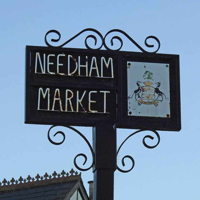
Needham Market town sign
The sign is the armorial bearing of Charles Ashburnham (1803-1848) although he has no recognised links with the town but the football club have adopted it. What the town does have which is completely ignored is an interesting history. Chainhouse Road and The Causeway both created at the time of the plague from 1663 to 1665 when Needham was just a hamlet of Barking and the church was just a chapel of ease.
The Victorian railway station, built in 1849 and still running. Needham Lake is a former gravel pit and a tourist attraction in the summer months. June Brown the actress, who played Dot Cotton in EastEnders was born here. Link
The Victorian railway station, built in 1849 and still running. Needham Lake is a former gravel pit and a tourist attraction in the summer months. June Brown the actress, who played Dot Cotton in EastEnders was born here. Link
Village Signs of East Anglia
Village signs are typically placed along the principal road or in a prominent location such as a village green or close by the church. The design often depicts a particularly feature of the village or a scene from its history, heritage, or culture. They are typically made of wood or metal or a combination of both, the designs are often made by the local community.
Although they do appear in villages and towns all over the country they are more prominent in East Anglia than elsewhere in the country.
 Map © Crown Copyright")
TIP: Click the map for more Large scale mapping
- Grid Square
- TM0855, 266 images (more nearby 🔍)
- Photographer
- Adrian S Pye (more nearby)
- Date Taken
- Monday, 26 October, 2020 (more nearby)
- Submitted
- Wednesday, 28 October, 2020
- Subject Location
-
OSGB36:
 TM 08736 55196 [1m precision]
WGS84: 52:9.3340N 1:2.9997E - Camera Location
-
OSGB36: TM 0873 5518
- View Direction
- North-northeast (about 22 degrees)